|
MAIN PAGE
> Back to contents
Urban Studies
Reference:
Razvodova I.
The main features of the spatial structure of cities with a free landscape layout (The city of Yelets, Lipetsk region).
// Urban Studies.
2023. № 4.
P. 16-31.
DOI: 10.7256/2310-8673.2023.4.43451 EDN: DRTYSV URL: https://en.nbpublish.com/library_read_article.php?id=43451
The main features of the spatial structure of cities with a free landscape layout (The city of Yelets, Lipetsk region).
Razvodova Yuliya
Graduate student, Department of Design, Art Education and Technology, Yelets State University.
399770, Russia, Lipetsk region, Yelets, Ordjonikidze str., 78

|
ularazart@gmail.com
|
|
 |
|
DOI: 10.7256/2310-8673.2023.4.43451
EDN: DRTYSV
Received:
27-06-2023
Published:
12-11-2023
Abstract:
The object of the study is the building system of the city of Yelets, developed by medieval architects and preserved to this day. The subject of this study is the main features of the spatial composition of the city of Yelets. The work is devoted to identifying the patterns underlying the unique development, which will not only preserve the advantages of the appearance of the city, but also competently develop the space in the future, taking into account current trends. The work is based on the study of Russian cities by G. V. Alferova, conducted in the second half of the XX century. Alferova revealed the presence of a compositional design in the construction of ancient cities. In this article, Alferova's ideas are developing. As a result of a systematic analysis of sources on the history of the Yelets Region, as well as a full-scale survey of the central and right-bank parts of the city, the main features of the spatial structure of the city are determined: complex multidimensional compositions of dominants, harmoniously subordinated to the natural features of the landscape; thoughtful organization of the so-called "prozors", creating a transparent open system of the city; the ability of the city to "accommodate" and arrange there are objects of different styles nearby, provided that the general rhythmic pattern is observed. Some weak points of the city were identified, formed due to the disregard by developers of the basic principles of city development. This study can help the development of not only Yelets, but also many cities with a similar type of layout.
Keywords:
Yelets, dominants, landscape layout, topography, building silhouette, module, panorama, town, image of the city, visual perception
This article is automatically translated.
You can find original text of the article here.
The process of centralization in modern Russia is gradually changing. The flow of population migration to large cities continues, but already today it is possible to trace some changes related primarily to the development of technology and the opportunity for many to be more mobile and/or work remotely [1, 2]. People's interest in the surrounding reality is also noticeable, new trends are emerging in the requirements of a citizen to his place of residence accommodation. These requirements are associated with the possibility of choice, as well as with the increasing development of the level of perception of the environment of the citizen himself. Many (but by no means all) of modern man's requirements for the environment can unexpectedly be met in medium and small Russian cities [3]. Namely: low-rise buildings; walking accessibility to the main elements of infrastructure; a well-equipped courtyard, developed social ties between residents of the district; proximity to natural areas, parks and squares [4, 5]; less traffic; ease in identifying children in public institutions in a convenient place and without queues; the possibility of daily contemplation of the beauty of the artistic the appearance of an urban composition, which is usually based on historical buildings. The last element, perhaps, is not formulated by the citizens themselves as one of the key ones, but it is he who is understood by the author of this article as the basis for naming a settlement with the term "city". In part, the requirements of modern man are realized by the exurbs growing around large cities, where wealthy families from large cities move. But still, life in the village generates a number of other problems: access to the developed infrastructure of a large city becomes more complicated, a person becomes "tied" to transport; educational institutions are either also located in the city, or if you want to study near home, you have to face limited choice or lack of it; the environment in the village does not have diversity, prompting a person spend more time inside the dwelling. Also, with the increased value of time, both a resident of a large city and a resident of exurbia are forced to spend several hours a day on the road. With all these advantages of small and medium-sized Russian cities, of course, it cannot be argued that they fully meet the expectations of the level of development of the environment for a modern person. The main problems are connected with illiterate decisions of developers of the last decades, who did not take into account the original compositional design when building the city. The listed problems and the need to find solutions to eliminate them determine the relevance of the study of the urban environment of small and medium-sized cities. It is interesting to consider the space of the ancient city of Yelets as a typical city among other small and medium-sized cities, combining all the above features, but at the same time as a unique city with a unique appearance, due to its location and its role in the history of our state, as well as a special approach to the organization of the urban system. This work is interdisciplinary in nature. Architects, art historians, historians, local historians, sociologists, philosophers and cultural scientists are engaged in the study of the urban environment. Within the framework of the culturological approach, the main emphasis is placed on the peculiarities of human perception of the urban environment, but it is necessary to attract special literature on other areas. A.V. Ikonnikov [6] was engaged in the study of the urban environment, who examined in detail the interaction of elements of architectural development. N. N. Baranov [7] analyzed, in particular, the relationship of background development to individual dominant structures. M. G. Barkhin studied the urban structure and composition of urban development [8]. In the West, urban space was studied by K. Lynch [9], who laid the foundations of modern mapping. E. Soya wrote about the city from the point of view of space [10]. The study of the visual perception of the urban environment is impossible without referring to the work of the American scientist A. Arnheim [11]. His book on the psychology of art "Art and Visual Perception" is a desktop for students of all art, architecture, design, psychology and other universities. Questions about the essential processes of perception were considered by M. Merleau-Ponty [12]. Modern researchers of urban spaces are increasingly turning to general patterns and the mutual influence of the environment and man. Neuroscience, which studies human consciousness, already formulates the relationship between the environment and human cognitive abilities, the term "enriched environment" appears, which scientists have yet to reveal [13, 14]. The relevance in the study of the mutual influence of the environment and man is due to the increase in the average life expectancy of a person in the XXI century, which generates the problem of oppression of mental health and cognitive abilities of a person. Professor V. A. Filin [15] has created a new interdisciplinary direction in the study of urban environment space – video ecology. He described the signs of an aggressive environment and its impact on a person's mental health. Filin also showed the functional role of architectural decoration, in contrast to the skepticism previously accepted in constructivism towards "decorations". Prominent scientist T. M. Dridze [16] in a sociological study also raises questions about the importance of preserving the compositional design of historical buildings and competent design of modern architecture. She formulated the main problems of modern design that are still relevant. Consequently, the issues of preservation and protection of historical cultural heritage become an object of interest not only for historians, local historians and architects, but also for representatives of social sciences. The research work on identifying methods of protecting the silhouette of historical buildings was carried out by A. N. Nazarova [17] on the example of the historical settlement of St. Petersburg. Z. K. Petrova [18] described the role of the cultural landscape in improving the comfort of the urban environment. N. M. Velikaya wrote about the cultural development of small and medium-sized cities of Russia through the prism of the study of identity [19]. A. A. Potapenko conducted a study on the development of the framework of the city, the identification of imbalances based on the analysis of cellular data [20]. The study of multilevel open urban spaces by E. V. Fomina and N. I. Barsukova seems interesting within the framework of this work [21]. Architects, historians, local historians and art historians have been studying Yelets in different years. The history of the construction of Yelets Krai was studied by V. P. Gorlov and A.V. Novoseltsev in the fundamental work "Yelets has been built for centuries" [22]. And together with N. A. Tropinin, the above-mentioned scientists collected and adapted for reading documents on the construction, settlement of Yelets and its environs in the XVI century [23]. Many works are devoted to the cultural heritage of the city of Yelets, individual monuments and architectural complexes.
Today, on the basis of the I. A. Bunin Yelets State University, D. A. Lyapin, N. A. Zhirov, and A. R. Melnikova are conducting a study [24, 25] of the so-called Belgorod line (military fortifications and settlements of south-Central Russia in the XVII - first half of the XIX centuries), the main result of which it will be the creation of a geoinformation system of the complex. The work is carried out in three directions: work in archives, archaeological excavations and computer mapping. Already now, as a result of the conducted research, firstly, the influence of the peculiarities of the social organization and forms of behavior of Russian society in the creation of a large complex of military-defensive structures has been established; secondly, the specifics of the actions of the authorities and society in the century; thirdly, how the process of construction of the Belgorod line affected the history of the region in the future. Thus, having listed only some sources, one can see what kind of layer of works has been created and continues to be created on the topic of studying and developing the urban environment. However, the current state of the visual space of cities, especially small and medium-sized ones, is still poorly understood. Cultural heritage objects are protected by the state [26], while the spatial layout of the urban environment as a whole requires attention from the city administration and developers. G. V. Alferova has been studying small and medium-sized cities of Russia for more than 20 years [27]. Russian Cities of the XVI-XVII centuries, she devoted a whole section to Yelets, developed visual graphic schemes of the urban structure (Fig. 1). 
Figure 1 Graphic diagrams of the planning structure of Yelets, compiled by G. V. Alferova. a – the layout of the dominants of the city of Yelets; b – the scheme of the organization of the city of Yelets XVI-XVLL centuries.; c – the planning structure of the city of Yelets in the XIX – early XX century.; d – topographic plan of the city of Yelets 1769. Before her research, the theory prevailed that ancient Russian cities appeared as a result of the sprawl of the village, so their layout was spontaneous. Scientists attributed the beginning of meaningful design of cities to the period of the XVI-XVII centuries – the time of mass construction and the appearance of the first documents on the redevelopment of ancient cities. However, according to the results of a study by a team of experienced architects of more than 20 Russian cities, G. V. Alferova concluded that the theory of chaotically arising buildings of ancient cities is not true. The architect claims that the cities were built according to a strictly defined plan, that the artistic appearance of many ancient cities that has survived to this day, favorably emphasizing the features of the landscape of the area, is the result of a high level of urban planning, and not a spontaneously formed composition. In Yelets, as in other cities, in the middle of the XVII century, a change in the layout of the historical center was carried out in accordance with the Master Plan sent from Moscow. Also, after the fire of 1649, buildings are already being built of stone, instead of the previous wooden ones. But the new building is made according to the same principles as the ancient one. Moreover, even the reconstruction of the center according to the regular type already in the XVIII century is carried out without serious interventions – architects only "straighten" the streets a little, without making serious changes to the established rhythm of development (Fig. 2). 
Figure 2 The general plan of Yelets 1770 Architect A. Kvasov Alferova attributed the compositional solution of Yelets to the last of the three types of cities of medieval development identified by her: the center of the urban settlement is located on a promontory at the confluence of the small and large rivers (the Pine River and the now crushed Yelchik (the former name is Yelets)); temples were erected along the breastwork of the high river banks, and, as a rule, they were put below the top of the mountain and on the same horizontal. Thus, Gali Vladimirovna makes a fair conclusion that the originality of medieval cities is not correctly determined by their planning structure alone. Similar statements can be found in the works of the already mentioned Gorlov, Novoseltsev, Lyapin – about the important role of landscape in the construction of Yelets [22, 24]. The plan is secondary, the spatial system is primary. 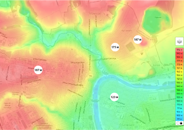
Figure 3 Topographic map of Yelets (https://ru-ru.topographic-map.com/map-s5g4b3/Елец /?center=52.63202%2C38.50794&zoom=14)
The topographic map of Yelets (Fig. 3) clearly shows that the landscape of Yelets is extremely heterogeneous. The differences reach 70-150 meters. The historical center (the left bank) is built on a hill, its height is 220 meters above sea level, and the right bank (the Zasosenskaya part (the former White Settlement)) is 140 meters. The initial construction of the city on the hill of the left bank was due to the defensive function of Yelets, but by about 1685 the city was losing its military function, and the overgrown population moved outside the prison [24]. After a devastating fire, the city is being built in the same place, although there were serious disputes about the transfer of the center to another place (Mount Argamach was considered several times as the object of the main development). It turns out that such a compositional solution of urban development is not accidental – it arose as a result of discussions of professionals. The approach to the construction of cities of the XVII century was strict, thorough, did not imply a "free" interpretation of planning decisions, as well as haste: "In 1770, the commission developed the first plan of Yelets, which had to be restored after the devastating fire of 1769. In the year of the fire, a geodetic survey of the area was carried out and a "Plan for the city of Yelets was drawn up with the indication of the burnt and abandoned buildings of the Vyhan lands lying around it." This plan became the basis on which the new layout of our city was unregulated. The regular plan of Yelets, signed by architect Alexey Kvasov (Fig. 2), among 416 general plans of other cities, became part of the Complete Collection of Laws of the Russian Empire. Its execution became mandatory. The first general plan was also developed according to the principles of classicism. Rectangular blocks, wide straight streets from north to south and from east to west, rectangular, almost square squares. It seemed that the old layout was completely ignored. But upon careful examination of the drawing, it is clear that the rectangular grid of streets was placed so that a significant part of the already existing streets of Sovetskaya, Mira, Kommunarov, Oktyabrskaya has been preserved. When laying new streets, stone unburned buildings and churches were not subject to demolition. Thus, the backbone of the city, which existed two hundred years ago, was carefully preserved. The old community center — Red Square — received clear rectangular borders" [26]. Researching the Pilot Book [30], Alferova found out that medieval cities were built on the principle of a three-dimensional model, based on a module – a single predetermined size. All further proportional relationships in the city system were subject to this module, that is, all the dimensions of the city were multiples of the module. Alferova believes that it is more accurate to call such cities spatially modular, instead of the previously accepted term "city with a free layout". This statement contradicts the title of this work, but we consider it inappropriate to introduce the term "spatially modular city" in the title due to its insufficient disclosure in this work. Mentioning the mathematical connection between important elements of urban development is extremely important. This connection is clearly visible both in ancient photographs and in modern images of the city (Fig. 4): the location of heights in space relative to each other is harmonious and proportional. 
Figure 4 a – pre-revolutionary photograph of an urban silhouette (https://img-fotki .yandex.ru/get/38180/225044291.410/0_160513_cd87291c_orig.jpg ); b – modern view of the city silhouette from the automobile bridge (photo by the author) The harmonious interrelation of the three main elements of urban development – terrain, dominants, ordinary street buildings – form an original, complex organic image of the city. In the works of many scientists engaged in the study of the urban environment, there are descriptions of the composition of architectural complexes as spatiotemporal art forms [6, 7, 8]. The terms "dominant", "rhythm", "culmination", familiar to describe a musical composition, are also used when describing architectural complexes. Two of the five elements of the urban system proposed by Kevin Lynch [9] also logically include a characteristic of movement: "path", "landmark". The third element "border" indirectly blocks the dynamic change of the terrain from one type to another, which can be felt as a result of its intersection. This article does not provide for the analysis and analysis of terminology, but we consider it important to focus on the obvious understanding of the dynamic aspect in the study of the urban environment. G. V. Alferova also emphasized the role of movement in observing the city system, she introduces the concept of "insight", that is, the gap between houses with a view of the dominant or part of the panorama, unexpectedly "arising" in the course of the observer's movement along the street. The insight for Yelets is the most important element that makes the city transparent. As a result of the field study, two types of prozors were identified in the city. The first type is an insight with a view of the dominant (it acts as a Lynch reference point) (Fig. 5). 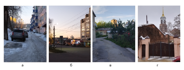
Figure 5 Examples of prozors with a view of the dominant: a – view of the Ascension Cathedral from the courtyard on Victory Square; b – view of the Cathedral from the right bank;c – view of the Intercession Church from the central courtyard on Lenin Street;g – view of the bell tower of the Assumption Church from Mira Street (photo by the author).
The second type is an insight at the end of the street, opening a piece of the panorama (Fig. 6). 
Figure 6 Examples of prozors at the end of the street opening a piece of panorama: a – Leo Tolstoy Street, an insight into part of the panorama of the right bank; b – Pushkin Street, an insight into the Church of the Icon of the Mother of God and the panorama; c – Cooperative Street, a view of part of the panorama of the right bank; d – Ordzhonikidze Street, a view of part of the panorama of the left bank (photo by the author).
The visionaries take advantage of the heterogeneous landscape of the city, emphasize it, the city becomes interesting to perceive and at the same time complex. The principle of complexity and layering is also observed in the construction within the blocks. Unfortunately, the modern approach to building does not always take into account the original compositional idea. As you move westward along Ordzhonikidze Street (the former name is Voronezh), the view of the panorama of the right bank is shown one after another by the notes of the dominates (the Church of St. Michael the Archangel, the Water Tower, the steeple of the bell tower The Assumption Church), which prepare the observer for the upcoming climax, which falls on him when approaching the pedestrian bridge (Karakumovsky) with a grandiose view of the silhouette of the historical building, striking with the beauty of the compositional organization around the main urban dominant – the Ascension Cathedral. However, it was not possible to find a decent place to view the panorama: the most advantageous points are located near pedestrian crossings crossing a busy road (which clearly encourages the pedestrian to speed up his pace, rather than stop for contemplation), on a car bridge and on a narrow sidewalk in front of shops with parking (Fig. 7). The most spectacular view is available in driving time on the road bridge (fig. 4, b). 
Figure 7 Graphic representation of the silhouette of the historical building; The location of the dominants that make up the composition of the silhouette of the historical building of Yelets on the map. A and B are available viewing points, the arrows show the direction of view (photo by the author). The perception of the panorama is also complicated by the unfinished building of 2000 located near the bridge, fenced with a construction fence. The weak organization of such a valuable place for the city is partially compensated by the Pushkin Square, which was landscaped in 2022 (Fig. 8). This object is an example of a well-planned public space that not only does not destroy the constructive plan of the architects of the past, but also competently fits into the landscape. 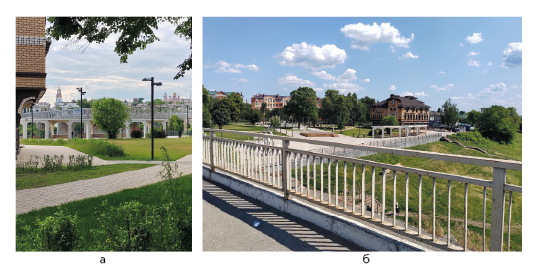
Figure 8 Pushkin Square, Yelets. A – view of the Karakum Bridge and part of the silhouette of the city from inside the square, b – view of the square from the Karakum Bridge (photo by the author).
The advantage of Pushkin Square is also the style in which it is made. The modern minimalist stylistic solution favorably emphasizes the beauty of historical buildings, and the presence of interesting objects in the square for the interaction of both adults and children make it a popular public space. There are no difficulties in combining different styles, as a rule, buildings from different eras perfectly coexist with each other, even enrich the urban space both visually and semantically. On the contrary, the hotel building, made in the "near-historical" style (in the right part of the photo in Fig. 8, b) looks heavy and alien. A building of this type is not uncommon for Yelets. Perhaps the architects and customers of such structures are trying to emphasize the ancient history of the city. Unfortunately, as can be seen from practice, this technique does not work, but rather, on the contrary, worsens the perception of truly historical buildings. We believe that this is primarily a problem of design, since an attempt to artificially form the "meaning" of an object [9] is always doomed to failure due to a broken sequence of design stages, where functionality, relevance and recognizability form the "meaning", and not vice versa. It can be concluded that in order to reveal and increase the advantages of the city, it is important not only to take into account the original plan, but also to focus on modern needs and requirements, otherwise not only new buildings will look "dead", but the former advantages may fade or be lost altogether. A panorama of the Zasosenskaya part of the city has a serious potential for enriching the visual environment of the city, the view of which opens from many places on the right bank (Fig. 6). However, at the moment this view is unremarkable. And some objects completely disfigure it. 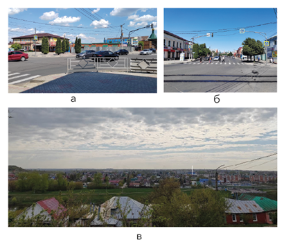
Figure 9 a and b – the area of the Zasosensky market, c – a view of the panorama of the Zasosenskaya part of the city (photo by the author). In Figure 9b, a white vertical stripe shows the approximate location and height of the lost Trinity Church, made in a rare Greek-Byzantine style (Fig. 10). Figure 9a-b shows that the absence of an important organizing element affects the square itself, although it is difficult to call this place an area today. Despite the proximity of several educational institutions, a shopping center, transport stops, this space is deserted, there are no places for citizens to interact. Objects "fall apart" and are completely unreadable. In general, there is disorganization, looseness and general unsightliness of this place. 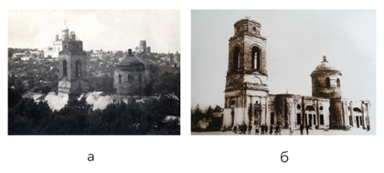
Figure 10 a – the explosion of the Trinity Church, the Resurrection Cathedral and the Church of the Intercession are visible in the background (https://vif-vrn.ru/download/file.php?id=5593&mode=view ); b – Trinity Church (https://rus-towns.ru/wp-content/gallery/stati/elets-troickaya-cerkov-1960.JPG ).
The designation of the above problems is important first of all for their solution. Of course, this article does not cover the whole complex of problems of the Yelets development, but understanding and following the logic of the original plan is necessary for the meaningful development of the environment in the future. Because the building system developed by architects of the past is open to changes and improvements – it does not limit modern architects in creativity, but only gives a hint to achieve the most expressive solutions. Conclusion. Yelets is a unique city with a complex spatial composition of buildings. Important advantages of the architectural environment of the city are: complex multidimensional compositions of dominants, harmoniously subordinated to the natural features of the landscape; comprehensive thoughtfulness of the urban development system; preservation of the irregular principle of the construction of cities XVI-XVII. Yelets is located in the center of a major transport interchange, one of the oldest universities in the country is located on its territory, there are many operating enterprises, therefore the city has the potential to develop not only a tourist destination. A city can become an attractive place for different people to live and work, with different needs. To do this, it is necessary to see in the already created building that is preserved "vital", which will allow creating a new "living" space.
References
1. Goncharov, S., Chukurov, A., Koroleva N., & Project Y. (2017). The modern multi-ethnic city as a space of threats and opportunities: anthropological dimensions of the living environment of a modern metropolis. Bulletin of Pskov State University. Series: Psychological and Pedagogical Sciences, 5. EDN ZGCIYT.
2. Vukovic, N. A., Larionova, V. A., & Morganti, P. (2021). Smart Sustainable Cities: Smart Approaches and Analysis. Economy of Regions, 17(3), 1004-1013. doi:10.17059/ekon.reg.2021-3-20
3. Kazaryan, R. A. (2021). Development of modern cities from the position of the ecological approach. Economics of Construction and Environmental Management, 1(78), 28-34. doi:10.37279/2519-4453-2021-1-28-34
4. Mackenzie, R. D. (2008). Ecological Approach to the Study of Human Community. Issues of Social Theory, 1(2) Retrieved from https://cyberleninka.ru/article/n/2000-04-027-makkenzi-r-d-ekologicheskiy-podhod-k-izucheniyu-chelovecheskogo-soobschestva-mckenzie-r-d-the-ecological-approach-to-the-study-of/viewer
5. Park, R. E. (1999). Human ecology. In a A.F. Filippov Theory of society.
6. Ikonnikov, A.V. (1985). Artistic language of architecture. Moscow, USSA: Art.
7. Baranov, N. N. (1980). Silhouette of the City. Leningrad, USSA: Stroyizdat.
8. Barkhin, M. G. (1986). City. Structure and Composition. Moscow, USSA: Nauka.
9. Lynch, K. (1960). The image of the city. London, England: The M.I.T. Press.
10. Soja, E. (2003). Writing the city spatially. City: Analysis of Urban Trends, Culture, Theory, Policy, Action, 7(3). doi:10.1080/1360481032000157478.
11. Arnheim, R. (1974). Art and visual perception. Berkeley, USA: University of California Press. [DX Reader version]. Retrieved from https://monoskop.org/images/e/e7/Arnheim_Rudolf_Art_and_Visual_Perception_1974.pdf
12. Merlau-Ponty, M. (1945). Phénomènologie de la perception. France, Paris: Gallimard. [DX Reader version]. Retrieved from https://vk.com/doc5787984_459107599?hash=mhNkpTVRNcE1ycNXR6ktTN2WXi01fQpDCi10tpkNxzs&dl=WzOcmEHfDyZBPRpb2nuEkgPggz4DNNjeECKMetZE3Ec
13. Dadashova, S. Н. (2022). Neuroscience and the new understanding of consciousness. Philosophy of Science, 3(94), 110-123. doi:10.15372/PS20220309
14. Krayeva, A. G. (2022). The proliferation of neuroscience ideas in art history: cognitive foundations and leading trends. Simbirskiy nauchniy vestnik, 2(46). 141-145. Retrieved from https://www.elibrary.ru/download/elibrary_50203066_27908761.pdf
15. Filin, V.A. (2006). Visual environment of the city. Problems of ecology, education, ecological culture, earth science, 2, 43-50. Retrieved from https://www.elibrary.ru/download/elibrary_17264593_39150521.pdf
16. Dridze, T. M. (1996). Socio-diagnostic study of the city. Bulletin of the Russian Humanitarian Scientific Foundation, 1, С. 95-103. Retrieved from https://www.elibrary.ru/download/elibrary_43850860_61145150.pdf
17. Nazarova, A. Y. (2022). Silhouette of building as a subject of protection of historical settlement (on the example of St. Petersburg). Urbanistics, 2, 69-87. doi:10.7256/2310-8673.2022.2.38289
18. Petrova, Z. K. (2020). The role of cultural landscapes in enhancing the comfort of the urban environment. In (Ed) Vernadsky, V. L. Landscape science and landscape ecology: adaptation of landscape and economic activity: Proceedings of the International Scientific and Practical Conference (412-416). Simferopol, 20-25 Simferopol: Crimean Federal University. V. I. Vernadsky.
19. Velikaya, N. M. (2021). Cultural development of small and medium-sized cities of Russia as a factor in the preservation of national identity. Observatory of Culture, 18(3), 240-253. doi:10.25281/2072-3156-2021-18-3-240-253.
20. Potapenko, A. A. (2022). Disproportions of the spatial structure of the city as a reserve for the development of the city framework: territorial and communication model and analysis of cellular data. Urbanistics, 4, 50-70. doi:10.7256/2310-8673.2022.4.37724
21. Fomina, E. V., & Barsukova, N. I. (2022). Multilevel open urban spaces: current trends. Urbanistics, 4, 20-33. doi:10.7256/2310-8673.2022.4.38355
22. Gorlov, V. P., & Novoseltsev, A. V. (1994). Yelets was built for centuries. Lipetsk, Russia: Lipetsk Publishing House. Retrieved from https://web.archive.org/web/20100822121836/http://allelets.ru:80/biblioteka/knigi-o-elce
23. Glazyev, V.N., Novoseltsev, A.V., & Tropin, N.A. (2004). Russian fortress on the southern borders. Documents on the construction of Elets, the settlement of the city and its environs in 1592-1594. In (Ed) Papkov, A. I. Bulletin of I.A. Bunin Elets State University (219-221). Yelets: Yelets State University.
24. Lyapin, D. A. (2012). Historical topography of Yelets in XVI-XVII centuries. West-Russia-East. Archaeology. History. Philosophy. Law, 2, С. 66-79. Retrieved from https://www.elibrary.ru/download/elibrary_20862386_40886361.pdf
25. Zhirov N. A., Melnikova A. R., & Lyapin D. A. (2023). Belgorod feature as a tool for the formation of local identity of the population of modern south of Central Russia. History: facts and symbols, 1(34), 155-157. Retrieved from https://www.elibrary.ru/download/elibrary_50349970_17044656.pdf
26. Kobzeva, I. A. (2022). Yelets. Objects of Cultural Heritage. Lipetsk, Russia: Regional Budgetary Institution "Publishing House "Lipetskaya Gazeta".
27. Alferova, G. V. (1989). Russian Cities of the 16th-17th Centuries Moscow, USSA: Stroyizdat.
28. Alferova, G. V. (1973). The Book of Kormchaya as the most valuable source of ancient Russian town-planning legislation. Its influence on the development of Russian cities. Byzantine times, 35.
Peer Review
Peer reviewers' evaluations remain confidential and are not disclosed to the public. Only external reviews, authorized for publication by the article's author(s), are made public. Typically, these final reviews are conducted after the manuscript's revision. Adhering to our double-blind review policy, the reviewer's identity is kept confidential.
The list of publisher reviewers can be found here.
The author presented his article "The main features of the spatial structure of cities with a free-landscape layout (using the example of the city of Yelets, Lipetsk region)" to the Ubranistics magazine, in which a study of the features of the layout and development of the studied city was conducted. The author proceeds from the study of this issue from the fact that modern small towns are able to meet the basic requirements of residents to their places of residence, namely: low-rise buildings; walking accessibility to the main elements of infrastructure; equipped courtyard, developed social ties between residents of the area; proximity to natural areas, parks and squares; less traffic; ease in determining children to state institutions in a convenient place and without queues; historical buildings and objects. However, the author also highlights a number of problems that arise as a result of living in such cities: difficult access to the developed infrastructure of a large city and educational institutions; undeveloped infrastructure and entertainment industry; large time costs for traveling to the right destinations. The author explains the existing problems by illiterate decisions of developers of recent decades, who did not take into account the original compositional design when building the city. Explaining the choice of the subject of the study, the author notes Yelets as a unique city with a complex spatial composition of buildings. Among the advantages of the architectural environment of the city, the author highlights: complex multidimensional compositions of dominants, harmoniously subordinated to the natural features of the landscape; comprehensive thoughtfulness of the urban development system; preservation of the irregular principle of urban construction XVI-XVII. Yelets is located in the center of a major transport interchange, one of the oldest universities in the country is located on its territory, there are many operating enterprises, therefore the city has the potential to develop not only a tourist destination. A city can become an attractive place for different people to live and work, with different needs. After analyzing the scientific validity of the studied issues, the author notes that the problem of urban environment research is interdisciplinary, as it is dealt with by architects, art historians, historians, local historians, sociologists, philosophers and cultural scientists. Within the framework of the cultural approach, the main emphasis is placed on the peculiarities of human perception of the urban environment, however, it is necessary to involve special literature on other areas. A detailed bibliographic analysis allowed the author to conclude that an impressive volume of works has been created and continues to be created on the topic of studying and developing the urban environment. However, the current state of the visual space of cities, especially small and medium-sized ones, is still poorly understood. Cultural heritage sites are protected by the state, while the spatial layout of the urban environment as a whole requires attention from the city administration and developers. The solution of this issue is the scientific novelty of the research. The relevance of the research is due to the need to find solutions to the problems identified by the author. The practical significance lies in the fact that on the basis of the I. A. Bunin Yelets State University, D. A. Lyapin, N. A. Zhirov, A. R. Melnikova, a study of the so-called Belgorod line (military fortifications and settlements of south-Central Russia in the XVII - first half of the XIX centuries) is conducted, the main result which will be the creation of a geoinformation system of the complex. The work is carried out in three directions: work in archives, archaeological excavations and computer mapping. The author notes that, firstly, the influence of the peculiarities of the social organization and forms of behavior of Russian society in the creation of a large complex of military defensive structures has already been established; secondly, the specifics of the actions of the government and society in the century; thirdly, how the process of building the Belgorod line influenced the history of the region in the future. The methodological basis of the research was an integrated approach, including general scientific methods of analysis and synthesis, historical and cultural method, analysis of project documentation. The theoretical basis was the works of such domestic and foreign researchers as V.A. Filin, N.M. Velikaya, G.V. Alferova, A. Arnheim, M. Merleau-Ponty and others. The empirical base was made up of graphical diagrams, planning documentation, maps and images of Yelets. The purpose of the study is to identify the main features of the spatial structure of cities with a free-landscape layout on the example of the development of Yelets in the Lipetsk region. In the study, the author carries out the thesis that medieval cities were built on the principle of a three-dimensional model, based on a module – a single set size. All further proportional relationships in the urban system were subordinated to this module, that is, all the dimensions of the city were multiples of the module. Russian Russian Cities of the XVI-XVII centuries by G.V. Alferova was taken as the basis of the study by the author, since before her research the theory prevailed that ancient Russian cities appeared as a result of the sprawl of the village, therefore their layout was spontaneous. Scientists attributed the beginning of meaningful urban design to the period of the XVI-XVII centuries – the time of mass construction and the appearance of the first documents on the redevelopment of ancient cities. However, according to the results of a study by a team of experienced architects of more than 20 Russian cities, G. V. Alferova concluded that the theory of chaotically arising buildings of ancient cities is not true. The author argues that the cities were built according to a strictly defined plan, that the artistic appearance of many ancient cities that has survived to this day, favorably emphasizing the features of the landscape of the area, is the result of a high level of urban planning, and not a spontaneously formed composition. In particular, in Yelets, in the middle of the XVII century, the layout of the historical center was changed in accordance with the Master Plan sent from Moscow. Also, after the fire of 1649, buildings were built of stone, instead of the previous wooden ones. But the new building is made according to the same principles as the ancient one. Moreover, even the reconstruction of the center according to the regular type already in the XVIII century was carried out without serious interventions – architects only "straighten" the streets a little, without making serious changes to the established rhythm of development: the plan is secondary, the primary is the three–dimensional system. The author attributes the compositional solution of Yelets to the following type of medieval building: the center of the urban settlement is located on a promontory at the confluence of the small and large rivers (the Pine River and the now crushed Yelchik (former name – Yelets)); temples were built along the parapet of the high river banks, and, as a rule, they were placed below the top of the mountain and on one side horizontally. The harmonious interrelation of the three main elements of urban development – terrain, dominants, and ordinary street buildings – form an original, complex organic image of the city. In conclusion, the author presents a conclusion on the conducted research, which contains all the key provisions of the presented material. It seems that the author in his material touched upon relevant and interesting issues for modern socio-humanitarian knowledge, choosing a topic for analysis, consideration of which in scientific research discourse will entail certain changes in the established approaches and directions of analysis of the problem addressed in the presented article.
The results obtained allow us to assert that the study of the layout and building of ancient Russian cities is of undoubted theoretical and practical cultural interest and can serve as a source of further research. The material presented in the work has a clear, logically structured structure that contributes to a more complete assimilation of the material. An adequate choice of methodological base also contributes to this. The bibliographic list of the study consists of 28 sources, which seems sufficient for the generalization and analysis of scientific discourse on the subject under study. The author fulfilled his goal, received certain scientific results that allowed him to summarize the material. It should be noted that the article may be of interest to readers and deserves to be published in a reputable scientific publication.
Link to this article
You can simply select and copy link from below text field.
|
|