|
MAIN PAGE
> Back to contents
Arctic and Antarctica
Reference:
Zemlianskova A.A., Nesterova N.V., Makarieva O.M.
The ice regime of the northeastern Russia
// Arctic and Antarctica.
2024. № 1.
P. 20-33.
DOI: 10.7256/2453-8922.2024.1.69791 EDN: DZOYRH URL: https://en.nbpublish.com/library_read_article.php?id=69791
The ice regime of the northeastern Russia
Zemlianskova Anastasiia Aleksandrovna
ORCID: 0000-0002-2249-5708
Laboratory assistant, Laboratory of Monitoring and Forecasting Climate Change and the Environment, North-Eastern State University, Magadan, Russia;
Junior Researcher and Postgraduate Student of the Institute of Earth Sciences, St. Petersburg University
685017, Russia, Magadan region, Magadan, Portovaya str., 13

|
anastasiazemlanskova@gmail.com
|
|
 |
Other publications by this author
|
|
Nesterova Nataliia Vadimovna
ORCID: 0000-0003-0677-4982
PhD in Technical Science
Senior Lecturer at the Department of Land Hydrology at the Institute of Earth Sciences, St. Petersburg University, St. Petersburg, Russia;
Junior Researcher of State Hydrological Institute
7-9 Universitetskaya Embankment, St. Petersburg, 199034, Russia
|
|
nnesterova1994@gmail.com
|
|
 |
|
Makarieva Ol'ga Mikhailovna
ORCID: 0000-0002-2532-4306
PhD in Technical Science
Head of Laboratory of Monitoring and Forecasting Climate Change and the Environment, North-Eastern State University, Magadan, Russia;
Leading Researcher of Earth Sciences, St. Petersburg University
685000, Russia, Magadan region, Magadan, Portovaya str., 13
|
|
omakarieva@yandex.ru
|
|
 |
Other publications by this author
|
|
|
DOI: 10.7256/2453-8922.2024.1.69791
EDN: DZOYRH
Received:
08-02-2024
Published:
15-02-2024
Abstract:
Transport links and provision of hard-to-reach settlements and mining enterprises play an important role in the economic development of the Arctic regions. In winter, winter roads are used as transport arteries; their mode of operation depends on the characteristics of the ice. Winter roads are used in Russia, Canada, USA, Finland, and China. Due to climate warming, the timing of the formation of ice cover on rivers is shifting to later times, and in the spring the ice is destroyed earlier. This could affect the delivery of vital supplies to remote regions. According to recent forecasts, it is assumed that heavy vehicles will not be able to use winter roads by the end of the 21st century. The purpose of the study is to analyze changes in the characteristics of ice cover on the rivers of the Northeast of Russia. To do this, a series of data was collected for the period 1940–2018 on the thickness of the ice cover at 80 hydrological stations located in the basins of the Yana, Indigirka, Kolyma rivers, rivers of the Chukotka Peninsula and the Sea of Okhotsk basin. The catchment areas range from 18.3 to 635,000 km2, and the duration of the continuous series ranges from 2 to 67 years. Three statistical nonparametric tests (Mann-Kendall, Pettitt and Theil-Sen) were used for evaluation. The following characteristics were considered: the maximum ice thickness and the date of its formation, the dates when the ice thickness reached 60 and 90 cm. During the period under review, the maximum ice thickness decreased by an average of 40 cm, while the date of reaching the maximum values remained almost unchanged. The period for the formation of river ice with a thickness of 60 and 90 cm, necessary for the passage of cars and trucks, respectively, has shifted by almost a month. The start date of freeze-up occurs on average 3–4 days later, and the end date of freeze-up occurs 5–8 days earlier. On average, the duration of freeze-up decreased by 5–15 days. The results obtained must be taken into account when drawing up the work schedule for winter roads. This is especially important for regions where communication between populated areas and mining enterprises is possible only through river arteries.
Keywords:
river ice thickness, the North-East of Russia, ice cover period, winter road, climate change, aufeis, ice phenomena, Arctic regions, cryosphere, ice reduction
This article is automatically translated.
You can find original text of the article here.
Introduction Transport links play an important role in the economic development of the Arctic regions. In winter, the river network is used as transport arteries. In the North-East of Russia, winter roads are being laid in the basins of the Yana, Indigirka and Kolyma rivers, the rivers of the Chukchi Peninsula and the Okhotsk Sea basin. Winter road is an expensive automobile, the operation of which is possible only in winter at a negative air temperature. An ice crossing is laid on the ice of rivers, lakes, reservoirs or seas only after careful verification of the thickness of the ice cover. Winter roads operate annually in countries such as Canada, China, the USA, Russia, Finland, Norway and Sweden. For winter garden equipment, it is necessary to know the design loads for different types of vehicles. Building regulations have established that ice with a thickness of 60 and 195 cm, respectively, is needed to travel through the winter road for wheeled vehicles weighing 15 and 100 tons. Due to the warming of the climate, changes in the ice regime of rivers are observed. The timing of the formation of the ice cover, as well as its characteristics, are changing. There is a reduction in the service life of winter roads. In [1] it is noted that in Canada, for the heaviest vehicles, winter roads will not be possible by the end of the XXI century. In the North-East of Russia, winter roads are laid along the Kolyma and Anadyr rivers in late October — early December, on the rivers of the Okhotsk Sea basin — in early September — mid—December and operate until the end of April - early May [2]. Winter roads are also laid along the rivers of the basins of the PP. Yana and Indigirka. In the Republic of Sakha (Yakutia), the length of winter roads is more than 9 thousand km, they provide communication between the center and the villages, and are used to deliver life-supporting goods. A significant obstacle to the normal functioning of winter gardens are ice and polynyas. The ice regime of rivers is important for the basins of northern rivers, their ecosystems and the economic development of Arctic industry and transport [3, 4]. The formation of the ice regime is determined by a number of factors, including water content, the type of river nutrition, heat exchange of water mass with the atmosphere, bathymetry and the structure of the riverbed [5]. At the moment, the future impact of climate warming on changes in the ice regime of rivers is widely discussed in the world [3, 4]. According to the estimates of the Roshydromet service,1), by 2039, the Siberian rivers are expected to reduce the ice age by 20-27 days and reduce the maximum ice thickness by 20-40%. According to Shiklomanov and Lammers[6], more accurate studies are currently needed using detailed observational data on smaller rivers. In world practice, satellite observations are widely used to study the ice regime of rivers [7]. The paper predicts a decrease in the seasonal duration of the ice cover by an average of 6 days per 1? increase in the average global surface air temperature. The use of MODIS satellite data made it possible to identify spatial and temporal patterns of ice cover changes in the basins of the Mackenzie, Lena, Ob and Yenisei rivers for the period 2000-2014 [8]. All statistically significant time trends are negative, which also indicates a general shift towards a decrease in the duration of the freeze. On the territory of the Tanana River research catchment (Alaska), it was found that ice melting is enhanced by an increase in the hydraulic gradient, an increase in groundwater elevation, an increase in air temperature, an increase in groundwater temperature and an increase in snow cover height [9]. It is expected that climate warming in regions with intermittent permafrost will increase the flow of groundwater into rivers, reduce the temperature gradient between the atmosphere and the ice-water interface and increase the thickness of the snow cover. The purpose of the study is to analyze changes in the characteristics of the ice regime of rivers in the North-East of Russia (1940-2018) on the basis of the developed database. The object of the study The territory of the North-East of Russia includes the basins of the Yana, Indigirka, Kolyma rivers, the basins of the Chukchi Peninsula and the Sea of Okhotsk (Fig. 1). The terrain is complex and diverse. It is represented by highlands, which are smoothly replaced by low mountains, internal depressions, etc. [2, 10]. The climate of the interior of the Northeast is harsh, sharply continental, and becomes milder when approaching the sea coasts. The average annual air temperature at the Oymyakon station (726 m) is -15.7?, and in Magadan (118 m) -2.8?. The coldest is January -46.4? (Oymyakon), closer to the sea the temperature rises to -16.4? (Magadan). The warmest month is July. The average long-term temperature in July at the Oymyakon station is +14.9?, in Magadan +11.8?. The cold period lasts from October to April, and the warm period lasts from May to September. The precipitation regime in the territory is heterogeneous, it is under the influence of cyclonic activity. There are cold (October—April, May) and warm (May, June—September) periods of precipitation of solid and liquid precipitation, respectively. The annual precipitation reaches 600 mm on the shores of the Okhotsk and Bering Seas (688 mm, m/s Suntar-Khayat, 2068 m; 561 mm, m/s Magadan), and in the lower reaches of the Kolyma River less than 200 mm. In most of the territory, the annual precipitation is within 300 mm. It is difficult to estimate the amount of precipitation, since most weather stations are located in river valleys at low altitudes, there is no information about the amount of precipitation in the mountains, at an altitude of more than 1,500 m. In the summer, mainly in July, there is a maximum of precipitation. The formation of snow cover in some areas begins in September. The maximum height is observed in March-April, throughout the territory it practically does not exceed 100 cm, on average it is 30-50 cm. In the second half of May, the stable snow cover collapses. The number of days with snow cover is 210-240 days. The maximum water supply in the snow cover ranges from 50 to 200 mm [2, 10]. Permafrost is an important component of the natural system of the North-East of Russia, only on the coast of the Sea of Okhotsk it is intermittent, its thickness does not exceed 0.2—0.3 m, there are islands of thawed rocks. Taliks are also found in the Kolyma River basin. In this territory and in the watersheds of the Chukchi Highlands, the permafrost capacity is 300-400 m. The thickness of permafrost rocks in the high-altitude areas of the Yana and Indigirka river basins can reach more than 450 m, in river valleys up to 180 m. The thickness of the active layer is 0.3—2 m [11].
The river network of the Northeast has a complex pattern. Permafrost in mountainous areas contributed to the formation of multi-armedness. Mountain rivers are characterized by rocky beds, abounding in rapids. In flat areas, river valleys are very wide, composed of alluvium, they are characterized by free meandering. The rivers are characterized by a regime with spring floods, strong summer and autumn rain floods. Winter lack of water on all rivers is long (6-8 months), many small and medium-sized rivers freeze to the bottom. Ice is widespread in the North-East of Russia, the total area of which, according to modern estimates, is 4,529 km2, and the volume is 10.6 km2. The average glaciation of the river basins in which the runoff is monitored ranges from 0.2 to 1.4%. It is maximal in the private catchments of the Indigirka River [12]. 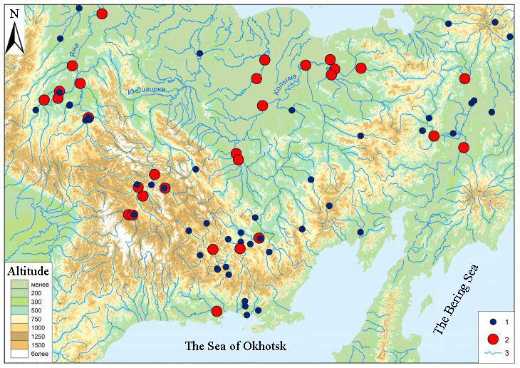
Fig. 1. Database of ice thickness on the rivers of the North-East of Russia. 1 — hydrological posts that are listed in the database; 2 — hydrological posts, according to which the analysis was carried out; 3 — rivers. Materials and methods To assess the changes, a number of data was collected for the period 1940-2018 on the thickness of the ice cover at 80 hydrological posts located in the basins of the Yana, Indigirka, Kolyma rivers, the rivers of the Chukchi Peninsula and the Sea of Okhotsk basin. The catchment areas range from 18.3 to 635,000 km2, and the duration of a continuous series ranges from 2 to 67 years (Fig. 2, Table 1). Table 1. The period of observations at hydrological posts selected for the analysis of the ice cover of rivers in the North-East of Russia. | ID | The river is the name of the post | S | Y | N | G | | 01001 | R. Kolyma - S. Orotuk | 42600 | 1957 | 61 | - | | 01010 |
R. Kolyma - P. Ust-Srednekan | 99400 | 1957 | 61 | 2001 | | 01018 | Kolyma River - settlement Zyryanka | 287000 | 1957 | 61 | 1964 | | 01176 | Bohapcha river - 5.4km from the mouth | 13600 | 1957 | 61 | 2003, 2008–2009 | | 01397 | R. Maly Anyui - S. Island |
30000 | 1957 | 61 | 1958, 1976–1977, 1999–2001 | | 01398 | R. Maly Anyui - S. Anyuysk | 121000 | 1957 | 61 | - | | 01497 | Anadyr river - settlement New Eropol | 47300 | 1957 | 61 | 1997, 2004–2013 | | 01504 | R. Main - S. Vaegi |
18600 | 1957 | 61 | - | | 01508 | R. Enmyvaam (Enmuvey) – HMS Enmuvei (village of Mukhomornoye) | 11400 | 1957 | 61 | 1967 | | 01566 | R. Taui - S. Talon | 25100 | 1957 | 61 | - | | 01578 | R. Yasachnaya - S. Nelemnoye |
32000 | 1972 | 46 | - | | 01596 | Bolshoy Anyuy River - HMS Konstantinovskaya | 49600 | 1978 | 40 | - | | 01801 | Kolyma River - Srednekolymsk | 361000 | 1957 | 61 | 1964 | | 01802 | Kolyma River - Kolymskoye |
413000 | 1965 | 53 | - | | 01805 | R. Kolyma - R.P. Chersky | 635000 | 1940 | 78 | 1960–1965, 1996–2002 | | 03414 | Yana River-Verkhoyansk | 45300 | 1951 | 67 | - | | 03424 | R. Sartang - Bala | 16700 |
1951 | 67 | - | | 03430 | R. Dulgalakh - Tomtor | 23900 | 1951 | 67 | - | | 03443 | the river Adycha - Ust-Charky | 52800 | 1956 | 62 | 1959 | | 03445 | R. Adycha - Yurduk-Kumakh | 89600 | 1951 |
67 | - | | 03483 | R. Bytantai - Asar | 40000 | 1951 | 67 | - | | 03488 | R. Indigirka - Yurts | 51100 | 1956 | 62 | - | | 03489 | R. Indigirka - Indigirsky | 83500 | 1958 | 60 |
- | | 03499 | The Suntar River is the mouth of the Sakharynya River | 7680 | 1955 | 63 | 1963, 1965, 1968, 1971, 1973–1976 | | 03503 | R. Agayakan - HMS Agayakan | 7630 | 1952 | 66 | - | | 03507 | Elgi river - 5.0 km above the mouth of the Artyk-Yuryakh river | 17600 | 1951 | 67 |
1972, 1973, 1980 | | 03518 | R. Nera - village Ala-Chubuk | 22300 | 1961 | 57 | 1973, 1975 | | 03861 | R. Yana - Yubileynaya station (Kazachye) | 224000 | 1951 | 67 | - | | 03881 | R. Alazeya - Argakhtakh | 17700 | 1961 | 57 | 1965, 1972 | | 03882 |
R. Alazeya - S. Andryushkino | 29000 | 1961 | 57 | 1965, 1967, 1995–2004 | *ID is the number of the post; S is the catchment area, km 2; Y is the year of the beginning of observations; N is the observation period (up to and including 2018); G is the years in which observations were not carried out. Information from 1936-2008 was digitized according to the data of the "State Water Cadastre" [13-15], 2008-2018 was obtained on the website of the AIS GMVO 2). Three statistical nonparametric criteria (Mann-Kendall, Pettitt and Teil-Sena) were used to assess changes in ice thickness on the rivers of the Northeast according to the developed database [16]. Representative series were selected in this work in catchments of different areas. The following representativeness criteria have been selected: 1) the length of the analyzed series is more than 20 years; 2) the difference in the number of values before 1980 and after 1980 does not exceed 50%; 3) the availability of data in the modern period (after 2000). In total, data from 30 hydrological posts for the territory of Northeastern Russia were analyzed according to the following characteristics: maximum ice thickness, date of formation the maximum thickness, as well as the change in the date of formation of the ice thickness of 60 and 90 cm. These values are determined by building regulations for the passage of wheeled vehicles weighing 15 and 35 tons, respectively, during a short-term thaw (air temperature 0? and above)3). 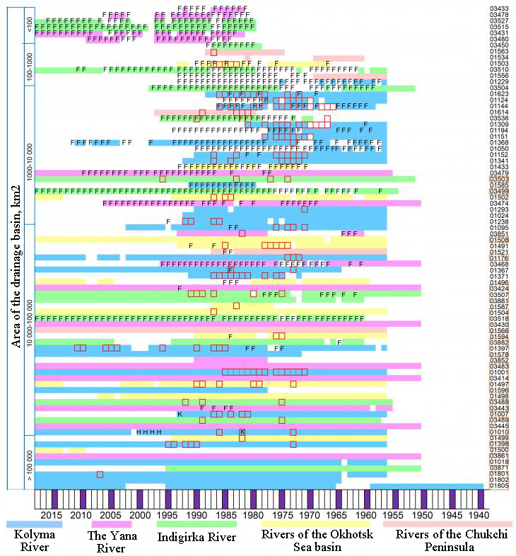
Fig. 2. Availability of data on the ice regime of small, medium and large rivers in the North-East of Russia. Note: the orange rectangle is the analyzed row (see the table. 2); F — the river is frozen to the bottom; red square — the outlet of glacial waters to the surface of river ice; H — the thickness of the ice is influenced by the construction of the Ust-Srednekanskaya HPP; K — the thickness of the ice is influenced by the discharge of water from the Kolyma reservoir. The results of the study According to the results of the analysis of data from 30 hydrological posts, it was found that the maximum ice thickness on the rivers of the Northeast has decreased, on average it has become less by 25.5 cm. The greatest changes are observed at post 01001 (located above the reservoir). During the period 1957-2018, the maximum ice thickness in this area decreased by 108 cm. Also, cases have been identified when the thickness of the ice in the modern period is greater. For example, at post 03483 for the period 1951-2018, it increased by 59 cm or 36%. The average date of formation of the maximum ice thickness has not changed, however, significant deviations are observed at some posts, for example, at posts 01504 and 01566 towards late and early formation for 40 days, respectively (Table 2). The analysis of the dates of formation of the ice thickness of 60 cm showed that the date of reaching this value did not change for 9 out of 30 posts, and on average for all analyzed posts it shifted by 23 days, to a maximum of 37 days. On the contrary, at post 01504, the formation of ice of such thickness was noted earlier (12 days earlier). A similar pattern was found for an ice thickness of 90 cm. At 7 posts, the date of formation of ice with a thickness of 90 cm has not changed, the average deviation for all posts is 33 days. The maximum possible ice formation of 90 cm is noted at post 01578 (63 days later from the average date of formation). 13 posts show a statistically significant trend towards the late formation of ice with a thickness of 60 cm, the same trend for an ice thickness of 90 cm (9 posts). The trend towards reducing the maximum thickness of the ice can be traced in 9 posts. The analysis also shows that at these posts, with a reduction in the maximum size of the ice thickness, the time for the formation of an ice thickness suitable for vehicles increases. Earlier formation of ice with a thickness of 90 cm is observed at 3 posts (for 14, 23 for 49 days), which may also be due to the formation of ice, which is an important factor complicating the functioning of winter ice trails. The ice thickness of 145 and 195 cm on the rivers is not formed every year, and therefore the analysis of the series is impossible. It is noted that the greater the thickness of the ice, the more pronounced the date shift. Table 2. Changes in the characteristics of the ice cover of rivers with a long series of observations until 2018 |
Post number | Change in the maximum thickness of the ice, cm | Changing the maximum thickness of the ice, % | Deviation from the average date of reaching the maximum, the pentad | The time limit for reaching 60 cm of ice | The time limit for reaching 90 cm of ice | | 01001 | -108 | -53 | 0 | 16 | 17 | | 01010 | 16 | 14 | 0 | 27 | -14 | | 01018 | 7.1 |
7.4 | 0 | 0 | 0 | | 01176 | -15 | -14 | 0 | 29 | 0 | | 01397 | -12 | -8.3 | 0 | 39 | 29 | | 01398 | -18 | -18 | 0 |
27 | 19 | | 01497 | 18 | 14 | 3 | 21 | 0 | | 01504 | 55 | 59 | 9 | -12 | 19 | | 01508 | -24 | -30 | -5 | 16 |
59 | | 01566 | -34 | -35 | -8 | 0 | -17 | | 01578 | -16 | -14 | 4 | 30 | 64 | | 01596 | -3.5 | -4.0 | -2 | 32 | 45 | |
01801 | -31 | -29 | 0 | 38 | 40 | | 01802 | -26 | -19 | -2 | 19 | 24 | | 01805 | -30 | -21 | 0 | 24 | 33 | | 03414 | -22 |
-16 | 0 | 12 | 36 | | 03424 | -22 | -16 | 0 | 28 | 28 | | 03430 | 26 | 16 | 0 | 0 | 0 | | 03443 | 35 | 23 |
0 | 0 | -23 | | 03445 | -25 | -11 | 0 | 0 | 0 | | 03483 | 59 | 36 | 0 | 0 | -49 | | 03488 | -24 | -11 | 0 | 0 |
0 | | 03489 | -98 | -52 | -2 | 16 | 37 | | 03499 | -7.3 | -8.0 | 0 | 0 | 0 | | 03503 | 98 | 39 | 3 | 0 | -13 |
| 03507 | -13 | -8.8 | 4 | 21 | 9 | | 03518 | 111 | 90 | 17 | 0 | 17 | | 03861 | -38 | -25 | 0 | 19 | 32 | | 03881 |
-5.3 | -5.0 | 0 | 0 | 0 | | 03882 | -21 | -16 | 0 | 0 | 6 | *Cells filled in gray correspond to statistically significant trends at p <0.10; at p <0.05 — in bold; at 0.05 <p <0.10 — in italics; underlined — a positive trend for maximum ice thickness and negative for the number of days reaching 90 cm At 12 of the 30 studied posts, there was a significant reduction in the maximum thickness of the ice cover at a significance level of p <0.10. On average, the decrease is 38.9 cm (27%) and varies from 16 cm (14%) (Yasachnaya River — Nelemnoye village, Kolyma River basin) to 108 cm (53%) (Kolyma River — S. Orotuk). A decrease in the maximum thickness of the ice is not accompanied by a shift in the date of occurrence of this maximum (Table 2). Only two posts (03489, Indigirka — Indigirsky river) and 01566 (Taui river — Talon village) have a date shift of 10 and 40 days, respectively. An increase in the thickness of the ice cover with an average value of 57 cm (40%) is observed at 7 posts. The maximum increase was recorded in the Nera river basin. Ala is a Chub (03518) and reaches 113 cm or 90%. A positive deviation from the average date of reaching the maximum thickness is observed on 4 of the posts under consideration. In general, an increase in ice cover occurs in the basins of the pp. Yana and Indigirka. At the same time, for all posts in these basins, lower ice thickness values were observed in the periods 1964-1967 and 2007, which generally coincides with the years of a sharp increase in runoff [17]. An important role in the formation of the ice cover is played by the ice formed in the gates of the posts. Thus, the maximum changes in the maximum thickness of ice are observed precisely at posts where ice phenomena are observed, and for such posts both a decrease in ice (for example, post 03489, Indigirka — Indigirsky river) and an increase (post 03503, Agayakan river — HMS Agayakan) are characteristic. In the basin of the Kolyma river — S. Orotuk (01001) the change in the thickness of the ice cover depends on the anthropogenic factor, since the data are distorted in connection with the construction of the Ust-Srednekanskaya HPP. Discussion Basically, studies of changes in the maximum thickness of the ice cover, the timing of autumn ice formation and its spring destruction are carried out on large rivers. For the northern regions, there are multidirectional trends in changes in the ice regime [18], which can vary both depending on the region and within river systems [8]. But in general, they indicate a significant softening of the ice regime, and changes in the maximum thickness of the ice over the last 30-year period occur more intensively compared with changes in the duration of the freeze-up [19]. Thus, for the rivers of the Arctic territory of Russia, the decrease in the thickness of the ice cover was mainly 10-20% [19]. In [6], statistically significant negative trends of maximum ice thickness on the rivers of Siberia are stated. On the Kolyma and Yana rivers, negative trends of maximum ice thickness (13 and 33 cm, respectively) and a decrease in the duration of ice formation by an average of 8 days were noted.
For the territory of the Republic of Sakha (Yakutia), on some rivers, such as Lena, Chara, Uchur, the change in the characteristics of the ice regime is significant, while on others (Timpton, Nyukzha) it is still quite weak [20]. On average, the duration of the freeze-up is reduced by 5-15 days. The ice age start date is on average 3-4 days later, and the ice age end date is 5-8 days earlier. Interestingly, for the territory of Yakutia, the average values of the maximum water level at the beginning of the ice age increased by 51-83 cm, which, according to the authors [20], is associated with an increase in the duration of the sludge and the volume of sludge in conditions of later dates of the beginning of the formation of the ice cover. For the rivers of the Upper Yenisei basin, the dates of solid ice formation have shifted to a later date by an average of 10 days, and the process of ice cover destruction begins 10-18 days earlier. Moreover, a statistically significant reduction in the total duration of glaciation was revealed on rivers with an average basin height of less than 1,500 m. The main reasons for these changes, according to the author [5], are a general increase in the water content of autumn and winter autumn, which is associated with an increase in the heat reserve of the water mass, as well as a decrease in the thickness of the ice cover as a result of a decrease in negative winter air temperatures. For Transbaikalia, the end date of the ice age on average shifted to an earlier date by 3 days. The dates were shifted to a later date by 1-10 days in 21% of the buildings. The dates have not changed in only 4% of the doors. Over a 50-year period, the maximum ice thickness on most rivers decreased (in a quarter of the strata, its decrease was more than 30 cm) [21]. For the territory of the rivers of the Arctic zone of Western Siberia, according to data from 40 hydrological posts (1936-2014), calculations showed the absence of statistically significant changes in the ice regime [22]. The change in the freezing dates of rivers and the maximum ice thickness depends more on the air temperature than on the water content of rivers [18, 21]. In [23], it is pointed out that the descent of the ice cover significantly depends on the air temperature, while the processes of ice freezing in autumn are of a more complex nature and show limited correlation with meteorological conditions. V. V. Feromov and L. N. Shantykova [5] argue that the observed shift in the dates of the appearance of solid ice depends mainly from the dynamic factor. In [24, 25], a hypothesis on the effect of river ice on inter-soil runoff is presented. Thus, in colder winters, with a significant thickness of ice, water consumption in small river basins decreases, and in less severe winters, the thickness of river ice decreases and higher runoff is maintained. At the same time, Shiklomanov and Lammers[6] did not confirm this theory and did not find a significant correlation between the maximum thickness of river ice and the average river flow in November-April. Thus, the results of the study of the dynamics of ice thickness on the rivers of the Northeast are consistent with the general trend of changes in the natural environment around the world. Conclusion The analysis of the dynamics of ice thickness on the rivers of the North-East of the country is carried out on the basis of the developed database for the period 1940-2018. Over the past fifty years, there has been a significant shift in the dates of ice thickness formation, for 60 cm — on average for 24 days (12-36 days) at 13 of the 30 hydrological posts, for 90 cm — for 38 days (17-64 days) at 9 posts. Earlier formation of ice of 90 cm is observed at 2 posts (for 14 and 49 days), which is also associated with the formation of ice, which is a factor complicating the functioning of winter ice trails. The development of new territories and the transportation of minerals is realized thanks to winter roads. In addition, the cost of creating winter roads can be several times lower than maintaining a permanent all-season transport artery. Shortening the operating time of winter roads can lead to significant economic damage. According to the results of the work carried out on the rivers of the North-East of Russia, the start date of the use of natural transport arteries may shift by a month or more. It is necessary to take this factor into account when drawing up the work schedule of winter trucks and apply methods of artificial freezing of the thickness of ice on rivers to increase the time of their use. This is especially important for regions where communication between settlements and mining enterprises is possible only through river arteries. Links to regulatory documents: 1) Assessment report on climate change and its consequences on the territory of the Russian Federation, vol. 1 and vol. 2. — Roshydromet, M., 2008. URL: http://climate2008.igce.ru 2) https://gmvo.skniivh.ru 3) VSN-137-89
References
1. Mullan D., Swindles G., Patterson T., Galloway J., Macumber A., Falck H., Crossley L., Chen J., & Pisaric M. (2017). Climate change and the long-term viability of the World’s busiest heavy haul ice road. Theoretical and Applied Climatology, 129, 1089-1108.
2. Surface waters resources of the USSR. (1969). Volume 19, North-East district. Gidrometeoizdat, Leningrad.
3. Magnuson J.J., Robertson D.M., Benson B.J., Wynne R.H., Livingstone D.M., Arai T., Assel R.A., Barry R.G., Card V., Kuusisto E., Granin N.G., Prowse T.D., Stewart K.M., & Vuglinsky V.S. (2000). Historical trends in lake and river cover in the Northern Hemisphere. Science, 289, 1743-1746.
4. Beltaos S., & Prowse T. (2009). River‐ice hydrology in a shrinking cryosphere. Hydrological Processes: An International Journal, 23(1), 122-144.
5. Paromov, V.V., & Shantykova, L.N. (2010). Izmenenie harakteristik ledovogo rezhima rek bassejna Verhnego Eniseya. Led i sneg, 2, 102-106.
6. Shiklomanov A., & Lammers R. (2014). River ice responses to a warming Arctic-Recent evidence from Russian rivers. Environmental Research Letters.
7. Yang, X., Pavelsky, T., & Allen, G. (2020). The past and future of global river ice. Nature, 577, 69-73. doi:10.1038/s41586-019-1848-1
8. Cooley, S.W., & Pavelsky, T.M. (2016). Spatial and temporal patterns in Arctic River ice breakup revealed by automated ice detection from MODIS imagery. Remote Sensing of Environment, 175, 310-322. doi:10.1016/j.rse.2016.01.004
9. Jones Ch., Kielland K., & Hinzman L. (2013). Modeling groundwater upwelling as a control on river ice thickness. Conference: 19th International Northern Research Basins Symposium and Workshop At: Southcentral Alaska, USA (pp. 107-115).
10. Surface waters resources of the USSR: Volume 17, Leno-Indigirsky district. (1972). Gidrometeoizdat, Leningrad.
11. Geocryology of the USSR. (1989). Eastern Siberia and the Far East. E.D. Ershov. (Ed.). Moscow, Nedra.
12. Alekseev, V.R., Makarieva, O.M., Shikhov, A.N., Nesterova, N.V., Ostashov, A.A., & Zemlyanskova, A.A. (2021). Atlas of Giant Aufeis-Taryn of the North-East of Russia; SB RAS: Novosibirsk, Russia.
13. Hydrological Yearbook (1936-1980): Volume 8. Issue. 0-7. The basin of the Laptev and East-Siberian seas to the Kolyma River, 855. Yakutsk Department of Hydrometeorology, Yakutsk.
14. Hydrological Yearbook: Volume 8. Issue 8. Volume 9. Issue 7. East Siberian, Chukchi, Bering Seas, Pacific Ocean (1957-1980). Kolyma Department of Hydrometeorology, Magadan.
15. USSR State Committee for Hydrometeorology and Environmental Control. (1981–2007). State Water Cadastre. Long-Term Data on the Regime and Resources of Land Surface Waters; Volume 1 (Issue 16, 17); Gidrometeoizdat: Leningrad, USSR.
16. Makarieva, O.M., Nesterova, N.V., & Zemlianskova, A.A. Certificate of state registration of the database No. 2021620268 «Ice thickness and snow height on small, average and large rivers of the Northeast (basins of the Yana, Indigirka, Kolyma, Anadyr rivers, basins of the Sea of Okhotsk and Chukchi Peninsulava) 1940-2018».
17. Makarieva, O., Nesterova, N., Post, D., Sherstyukov, A., & Lebedeva, L. (2019). Warming temperatures are impacting the hydrometeorological regime of Russian rivers in the zone of continuous permafrost. The Cryosphere, 13, 1635-1659.
18. Ginzburg, B.M. (2005). The timing of freezing and opening of rivers at the end of the XX century and their possible changes in the XXI century. Meteorologiya i gidrologiya, 12, 88-97.
19. Vuglinsky, V.S. (2014). Assessment of changes in water bodies ice regime characteristics for different regions of the country in modern climate conditions. Vestnik of Saint-Petersburg State University. Science of Earth, 13, 32-45.
20. Lobanov, V.A., & Goroshkova, N.I. (2019). Harakteristiki ledovogo rezhima rek Respubliki Saha (YAkutiya) i ih klimaticheskie izmeneniya. Proceedings of the Russian state hydrometeorological university, 55, 86-98.
21. Obyazov, V.A., Smakhtin, V.K. (2013). Vliyanie izmenenij klimata na rechnoj stok v zimnij period v Zabajkale. Meteorologiya i gidrologiya, 7, 95-102.
22. Agafonova, S.A. (2017). Ice regime of the rivers of the Arctic zone of Western Siberia in modern climatic conditions. Arctic and Antarctic, 2, 25-33. doi:10.7256/2453-8922.2017.2.22649
23. Newton, A.M.W., & Mullan, D. (2021). Climate change and Northern Hemisphere Lake and river ice phenology from 1931-2005. The Cryosphere, 15, 2211–2234. Retrieved from https://doi.org/10.5194/tc-15-2211-2021
24. Gurevich, E.V. (2009). Vliyanie temperatury vozduha na zimnij stok rek (na primere bassejna r. Aldan). Meteorologiya i gidrologiya, 9, 92-99.
25. Djamalov, R.G., & Potekhina, E.V. (2010). Prirodno-klimaticheskie i antropogennye prichiny izmeneniya podzemnogo stoka bassejna Leny [Natural-climatic and anthropogenic causes of changes in the underground flow of the Lena basin]. Georazrez, 1, 1-25.
Peer Review
Peer reviewers' evaluations remain confidential and are not disclosed to the public. Only external reviews, authorized for publication by the article's author(s), are made public. Typically, these final reviews are conducted after the manuscript's revision. Adhering to our double-blind review policy, the reviewer's identity is kept confidential.
The list of publisher reviewers can be found here.
The subject of the study, according to the author, is the forecast of the development of hydrological processes and changes in the ice regime of the rivers of the North–East of Russia in connection with changes in weather and climatic conditions in the modern period. The methodology of the study, the article indicates that the author collected a number of data to compile a database for 58 years for 80 hydrological posts in the river basin of the research site, information for 62 years was digitized according to the data of the "State Water Cadastre", and for the period 2008-2018 was obtained on the website of the AIS GMVO2), as well as an analysis of the map, literature data and stock materials. From the analysis of the article, it can be concluded that statistical analysis methods are used, in particular, three statistical nonparametric criteria (Mann-Kendall, Pettitt and Teil-Sena) were used to assess changes in ice thickness on rivers according to the developed database. The relevance of the topic raised is unconditional and consists in obtaining information about the economic development of the Arctic regions and the role of transport links in winter, the river network is used as transport arteries. In the North-East of Russia, winter roads are being laid in river basins - an expensive automobile, the operation of which is possible only in winter at negative air temperatures. An ice crossing is laid on the ice of rivers, lakes, reservoirs or seas only after careful verification of the thickness of the ice cover. In this regard, the authors' research on the dynamics of ice cover formation and the possibility of its use in modern conditions of changing weather and climatic conditions is very relevant. The scientific novelty lies in the author's attempt to establish, based on the research conducted, the dynamics of changes over the past fifty years as a significant shift in the dates of ice thickness formation, for 60 cm — on average for 24 days (12-36 days) at 13 of 30 hydrological posts, for 90 cm — for 38 days (17-64 days) at 9 posts. The earlier formation of ice is associated with the formation of ice, which is a factor complicating the functioning of winter ice trails.. This is an important addition to the development of geocryology and is of great practical importance. Style, structure, content the style of presentation of the results is quite scientific. The article is provided with illustrative material reflecting the process of statistical modeling. The article is illustrated with a visualized map, tables and a drawing. However, there are a number of wishes, in particular: The author of the article should focus in more detail on the analysis of the relationship between changes in average monthly temperatures for warm and cold periods of the year, taking into account that an increase in temperatures affects glacial processes. Interesting reasoned tabular data could be visualized in the form of diagrams and logic block diagrams. The bibliography is very comprehensive for the formulation of the issue under consideration, but does not contain references to normative legal acts and methodological recommendations. The appeal to the opponents is presented in identifying the problem at the level of available information obtained by the author as a result of the analysis. Conclusions, the interest of the readership in the conclusions there are generalizations that made it possible to apply the results obtained. The target group of information consumers is not specified in the article.
Link to this article
You can simply select and copy link from below text field.
|
|


