|
MAIN PAGE
> Back to contents
Arctic and Antarctica
Reference:
Khimenkov A.N., Sergeev D.O., Kulakov A.P., Romanov A.V.
Features of the organization of engineering and geocryological monitoring of highways operated in areas of permafrost distribution
// Arctic and Antarctica.
2023. № 4.
P. 125-157.
DOI: 10.7256/2453-8922.2023.4.68814 EDN: ICMZSC URL: https://en.nbpublish.com/library_read_article.php?id=68814
Features of the organization of engineering and geocryological monitoring of highways operated in areas of permafrost distribution
Khimenkov Aleksandr Nikolaevich
PhD in Geology and Mineralogy
Leading Scientific Associate, the Institute of Geoecology of the Russian Academy of Sciences
101000, Russia, Moskva oblast', g. Moscow, ul. Ulanskii Proezd, 13, stroenie 2

|
a_khimenkov@mail.ru
|
|
 |
Other publications by this author
|
|
Sergeev Dmitrii Olegovich
PhD in Geology and Mineralogy
Head of the Laboratory of Geocryology, Institute of Geoecology of the Russian Academy of Sciences
101000, Russia, Moscow, Ulanskii Pereulok Street 13, building #2
|
|
cryo2@yandex.ru
|
|
 |
Other publications by this author
|
|
Kulakov Artem Pavlovich
Junior researcher, Institute of Geoecology RAS
101000, Russia, Moscow, Ulansky str., 13 building 2
|
|
unruso@mail.ru
|
|
 |
|
Romanov Andrei Vyacheslavovich
Chief engineer of FKU UPRDOR Zabaikalia
672010, Russia, Zabaikalsky Krai, Chita, Anokhina str., 17
|
|
uprdorzabaikalie@mail.ru
|
|
|
|
DOI: 10.7256/2453-8922.2023.4.68814
EDN: ICMZSC
Received:
26-10-2023
Published:
21-12-2023
Abstract:
The object of study is to assess the state of engineering-geocryological monitoring of geotechnical systems (GTS) of highways in the area of permafrost distribution. The subject of the study is a set of measures to collect, process and accumulate data on road deformations, identify the causes of their occurrence and make decisions to eliminate them. The authors consider in detail such aspects of the topic as the causes of deformations of highway objects in different geocryological conditions. Particular attention is paid to the analysis of various options for obtaining primary information. From the very beginning of operation, highways in the permafrost zone are subject to intense deformations, which resume after repair and restoration work. The main conclusions of the study are: deformations on highways in the permafrost zone are caused by a complex of reasons associated with intense phase transitions of water in rock strata, which fundamentally distinguishes them from similar geosystems formed in more southern regions; engineering and geocryological monitoring of the objects under consideration must be carried out on the basis of interaction between the operating organization, the structure providing scientific support and the center for making management decisions; The existing regulatory framework does not correspond to the problems that arose during the operation of highways in the permafrost zone.
Keywords:
highway, roadbed, deformations, cryolithozone, frozen rocks, termokarst, thermoerosion, geotechnical system, geotechnical monitoring, engineering-geocryological monitoring
This article is automatically translated.
You can find original text of the article here.
Introduction In recent years, thousands of kilometers of modern paved roads have been built in the permafrost distribution areas. As it turned out, the existing methods of design, construction and operation do not provide the necessary parameters for the reliability and safety of these engineering structures. Significant sections of the roadway were deformed immediately after construction. The destruction continues during operation, and is repeated after the repair work. These trends are observed in all regions of Russia (Western Siberia, Taimyr, Yakutia, Transbaikalia), with different geocryological conditions, which is reflected in the publications of a number of researchers: V. G. Kondratiev, S.V. Kondratiev, E. A. Bedrin, A. A. Dubenkov, V. A. Isakov, V.I. Grebenets, Ya. I. Torgovkin, etc. Obviously, this problem can be partially solved by improving the quality of work at the stages of exploration, design and construction. One of the reasons for this is the lack of knowledge of the patterns of interaction between engineering structures of roads and the environment, expressed in the formation of a special geotechnical system (GTS). It should be borne in mind that the creation of a GTS highway is a frozen ground, significantly affects the geocryological conditions of territories, changing the relief, temperature regime and properties of frozen rocks, surface and hydrological conditions, vegetation, waterlogging, etc. These GTS, having a length of hundreds and thousands of kilometers, actively affect permafrost conditions, which is expressed in a sharp increase in paragenetically related complexes of cryogenic processes leading to the development of deformations on highway facilities. Engineering structures (embankments, recesses, culverts) and the natural soils at their base will undergo changes under the influence of natural and man–made factors, respectively. That is, there is a kind of adaptation of the created GTS to the changed geocryological conditions, with the loss of the functions of the technical component. This negative adaptation should be contrasted with a positive adaptation, which consists in the formation of a new stable GTS (albeit in local areas) corresponding to the changed natural conditions. To do this, it is necessary to carry out a complex of works including: 1. Fixation of deformations observed on highway structures (roadbed, embankment, berm, roadside ditch, etc.) identification of collapsing sections; 2. Conducting additional research to identify destructive processes, as well as trends and intensity of their development; 3. Development of design solutions to ensure the functioning of the disturbed area in the new predicted geocryological conditions; 4. Carrying out engineering and restoration works that ensure the stable long-term operation of the facility. This list of works should be included in the complex of engineering and geocryological monitoring of highways laid on the territory of permafrost distribution. Currently, the regulatory framework governing these areas has not been sufficiently developed. In "SP 313.1325800.2017. A set of rules. Automobile roads in permafrost areas. Rules of design and construction" the main attention is paid to construction technologies in the cryolithozone. ODM 218.2.086-2019 METHODOLOGICAL RECOMMENDATIONS ON GEOCRYOLOGICAL FORECASTING OF THE STABILITY OF ROAD STRUCTURES IN THE DESIGN, CONSTRUCTION is intended for experimental use in the design and reconstruction of road embankments, on permafrost soils and the development of a forecast of their thermal stability.. ODN 218.046-01, PNST 542-2021, ODM 218.8.001-2009 "Methodological recommendations for specialized hydrometeorological maintenance of road facilities". and ODM 218.8.002-2010 "Methodological recommendations for winter maintenance of highways using specialized hydrometeorological information (for experimental use)" have been developed for other conditions and can be used in fragments. The ODM 218.11.007-2023, introduced in 2023, "Methodological recommendations for the organization of engineering and geocryological monitoring and equipment of engineering and geocryological monitoring stationary posts in the highway right-of-way in the cryolithozone", significantly improved the situation. It combines various directions for monitoring the condition of highways passing through the territory of permafrost distribution: - collection, storage, processing and analysis of information on the state of frozen soils, processes and phenomena occurring in them, as well as changes in their condition; - assessment of the state of frozen soils and forecast of changes in the state under the influence of natural and (or) man-made factors; - development of proposals on the prevention of negative effects on permafrost soils; - assessment of the effectiveness of measures to control the state of frozen soils; - creation of a database integrating the information obtained during the monitoring.
The introduced ODM will undoubtedly contribute to improving control over the condition of highways laid in areas of permafrost distribution. The adopted document is of a recommendatory nature, therefore, some technological aspects that reduce the effectiveness of its application have not been worked out here. It is not specified which department and in which mode receives the primary information. This can be done by operating organizations in the mode of irregular visits or in a periodic mode with a clear indication of deadlines. They can also be carried out by employees of the analytical center formed by the operating organization, or a similar center within the framework of Rosavtodor. These observations can also be carried out by third-party organizations providing scientific support. It is not shown how information from stationary automatic observation posts and information obtained from field observations will be synchronized. It is not clear from the ODM where the primary information will be concentrated and how information flows between different departments will be organized. It does not reflect the procedure for conducting in-depth geocryological engineering work in areas of intensive development of hazardous cryogenic processes. The algorithm of managerial decision-making is not shown. These and other unresolved issues of creating a system of engineering and geocryological monitoring of highways operated in the territories of permafrost distribution show that this problem is far from being completed and requires further development The purpose of this article is to analyze the state of existing methods of engineering and geocryological monitoring of highways operated in the permafrost distribution area. As well as the development of proposals for its improvement. Permafrost conditions, cryogenic processes, deformations of highway objects in the area of permafrost distribution A distinctive feature of highways on the territory of the cryolithozone is the variety of permafrost conditions, manifested in the difference in the interaction of the highway with the soils of the bases. The soil strata in the territories crossed by roads and railways are characterized by a wide variety of permafrost conditions, reflected in the cryogenic structure, iciness, and temperature. Embankments or recesses formed as a result of road construction change the heat exchange with the underlying rocks and cause significant changes in them. The intersection of taliks can lead to their freezing, high-temperature frozen rocks can, on the contrary, thaw, and in low-temperature temperatures the temperature can rise. Temperature changes correspond to phase transitions and migration processes, which in turn will cause the development of a series of cryogenic processes in the underlying rocks, subsidence, heaving, water filtration, thermal diffusion, etc., the difference in the types of thermal interaction of embankments and underlying rocks. Geomorphological, geological, climatic, geobotanical and geocryological conditions of various regions of the cryolithozone affect the dynamics of the temperature field, the susceptibility of permafrost rocks to man-made loads and the potential for the development of adverse cryogenic processes within the GTS of roads and railways [1]. As an example, we will give the spatial differentiation of soil temperature in the landscapes of the Kolyma federal road. Soils with high temperatures (from 0 to -2 °C) occupy 25% of the territory, average temperatures (from -2 to -4 °C) occur in 54% of the territory under consideration, soils with low temperatures (from -4 to -6 °C) occupy 18% and the lowest soil temperatures (below -6 °C) They are found in 3% of the territory. The values of the depth of seasonal thawing in the buffer zone of the Kolyma highway are divided into 5 intervals. Values up to 1 m and 1-1.5 m each occupy 16% of the territory. The thawing depth of 1.5-2 m can be traced in 30% of the total territory, >2 m occupies 33% and 2-2.5 m – 5% of the total territory [2]. Along with local differences in geocryological conditions affecting the interaction of the road and the underlying rocks and reflecting landscape heterogeneity, their regional variability associated with zonal climatic changes also plays a significant role. The modeling of the temperature field conducted by V. A. Isakov for 11 points in the cryolithozone of Russia showed the presence of significant regional differentiation in the dynamics of the geocryological situation at the base of road embankments [1]. He identified 4 main types of quasi-stationary field (with a relatively stable average annual soil temperature at different depths) of bulk and natural soils within the GTS of roads and railways in the cryolithozone (Fig. 1). A) Stable type (Amderma, Anadyr) – characterized by stability or a decrease in the temperature of bulk and natural soils and the rise of the permafrost roof within the structure. B) The transitional low-temperature type (Vorkuta, Tazovsky, Norilsk) is characterized by an increase in soil temperature within negative values during the rise of the permafrost roof and, in some cases, a local decrease in temperature under the main platform of the embankment. The position of the upper boundary of permafrost rocks is close to the configuration of the embankment surface. Talik zones of insignificant (up to 1-2 m) power are formed at the foot of the slopes. C) The transitional high-temperature type (Naryan-Mar, Salekhard, Yakutsk) is characterized by a significant increase in temperature at the base of the embankment and the formation of talik zones under the slopes of the embankments. The negative average annual temperature of bulk and permafrost conditions of natural soils at their high (not lower than -1 °C) temperature remains under the main site. D) Unstable type (Krasnoshchelye, Chita, Bomnak) – characterized by the formation of a significant thawing bowl under a road embankment. The nature of the occurrence of the roof of permafrost soils for points with different types of quasi-stationary temperature field of soils is shown in Fig. 1.
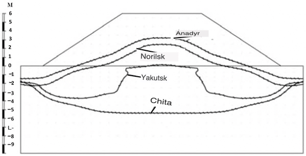
Fig. 1. The position of the permafrost roof at the base of the embankment in regions characterized by various types of quasi-stationary state of the temperature field [1]. The transformation of permafrost conditions and the formation of intrazonal landscapes associated with the activation of cryogenic processes in areas adjacent to highways. The construction and operation of roads and railways lead to significant changes in the permafrost conditions in the adjacent territories and the activation of dangerous engineering and geocryological processes in them. A zone of natural and anthropogenic landscapes is actively beginning to form here, in which the transformation of the primary structure of the original landscape is observed. Due to additional watering or desiccation (near recesses), the composition of plant communities changes. As a result of violation of surface runoff, surface reservoirs are formed, erosion and thermal erosion processes are activated near culverts, Violation of heat exchange conditions, lead to thawing of icy soils and subsidence. In other cases, violation of surface conditions can lead to freezing of thawed soils and heaving. Ice is beginning to actively develop in the sides of the recesses and in the places of the culvert. Since highways have a length of hundreds and thousands of kilometers, during their construction, zonal and regional factors that shape landscapes, and accordingly permafrost conditions, are transformed. A narrow zone of intrazonal landscapes is forming along the roads (from Latin. "intra" – inside) with increased dynamics of natural, including cryogenic processes that pose a danger to engineering structures. These landscapes arise when one of the factors important for their formation, in our case the GTS - highway, is so pronounced that it suppresses or changes the influence of other factors (climate). Thus, the landscape (indivisible by zonal and regional factors) will break up into local geosystems that differ in the material composition and structure of surface sediments, meso- and microforms of relief, moisture availability, and temperature regime. There are 5 groups according to the degree of activation of the processes forming intrazonal landscapes: weak, moderate, medium, strong, catastrophic. The degree of activation is assessed primarily by the area of the landscape, which can be affected by cryogenic processes in the development area. In addition, the rate of development of cryogenic processes, the degree of transformation and dismemberment of the primary relief, the possibility of attenuation of processes due to natural factors are estimated. Weak activation of processes means that cryogenic processes due to man–made causes occupy no more than 10% of the landscape area, moderate – up to 50%, average – about half of the landscape area, strong – more than 50%, catastrophic - more than 90% [3]. As an example of the influence of a highway on adjacent territories, the results of studies of changes in surface conditions and cryogenic processes within a peat bog crossed by a highway covered with concrete slabs on the territory of the Pur-Taz interfluve are considered (Fig. 2) [4]. In the areas adjacent to the embankment of the highway, there is a significant difference between the rates of degradation of the site to the southeast and to the northwest of the highway. When the snow melted, runoff from the watersheds (red arrows) accumulated at the bottom of the slope of the watershed. Further, the flow was distributed partly to the lakes and partly to the road (yellow arrows). The accumulation of water in roadside ditches led to the development of thermokarst. Here, the thermodenudation processes associated with the extraction of polygonal vein ice of the PLL are similar on both sides of the road. At some distance, the ratio of processes changes dramatically. In the studied area, there is a general slope of the surface in a northwesterly direction. Surface waters were discharged in this direction in undisturbed conditions. The road embankment was a kind of dam that hindered the natural discharge of surface waters. At the base of the embankment, a culvert is laid, timed to decrease the relief. In the northwestern section, a thermoerosive ravine has formed along the retreated vein ice, the top of which is confined to a culvert. Surface water was diverted through it to the nearest lake. The adjacent surfaces remain stable, there is no activation of thermal denudation processes. A different picture is observed in the southeastern part of the territory. Here, the embankment blocks the surface runoff. The culvert does not provide sufficient water discharge. As a result of the back-up of surface waters, a sharp activation of thermokarst occurs over re-vein ice (Fig. 2). 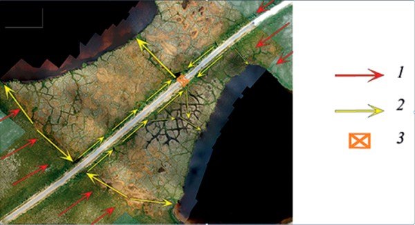
Fig. 2. The scheme of redistribution of surface water runoff: 1 – runoff from the watershed; 2 – runoff along the foot of the embankment and along the polygonal ditches of the peat bog; 3 – culvert [4]. The highway, having hindered surface runoff, had a stabilizing effect on thermal degradation processes in the northwestern part of the polygonal peat bog, reducing them to the local development of thermal erosion ravines. In the southeastern part, on the contrary, the destruction of frozen rocks was intensified due to the areal development of thermokarst over re-vein ice [4]. A similar example is considered in the work of Y. V. Tikhonravova [5], here there is also a significant influence of the highway in activating thermal denudation processes in adjacent territories and a sharp asymmetry in their manifestations (Fig. 3). 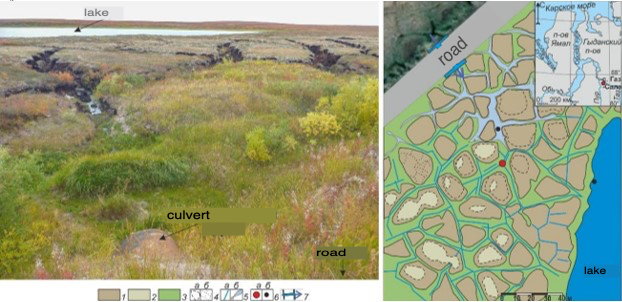
Fig. 3. Location and microrelief of the peat bog in Khasyrey of the Pur-Taz interfluve (figure compiled by: Ya.V. Tikhonravova, E.A. Sgrada): 1 – polygons; 2 – polygonal baths, swampy depressions; 3 – inter–polygonal depressions; 4 – contours of polygon rollers (a), cracks of high generation order (b); 5 - watered inter-polygonal depressions (a), watered gullies along the pulled out sections of polygonal-vein ice (b); 6 – clearing B8 (a), surface water sampling sites (b); 7 – culvert and flow direction [5].
Deformations of the roadbed in conditions of permafrost propagation. Deformations of highways operated in the area of permafrost distribution have various forms, scales of manifestations and their causes. They are common in all climatic and landscape zones, from the harsh conditions of the northern Arctic to the southern zone of permafrost [6, 7], etc. Let's consider some typical types of deformations. Long-wave longitudinal deformations. This type of deformations develops under conditions of regular changes in the longitudinal slopes of the roadbed in accordance with the irregularities of the natural relief and is associated with a complex of reasons: a change in the height of the embankment during the transition from the basin to the surface of the remnants, where the height of the embankment decreases sharply; the unevenness of the roof of frozen rocks associated with the presence of taliks in the basins; differences in temperature conditions and features of interaction with the soils of the foundations of embankments of various capacities. As a result, deformations develop, the scale of which is comparable to the scale of changes in the natural relief at the base of the embankment. Long-wave longitudinal deformations are widespread on highways. They can have different amplitudes (from several tens of centimeters to the first meters) and lengths (which, as a rule, exceed 50 m and can reach hundreds of meters). Longitudinal subsidence of high embankments. It is associated with the peculiarities of the interaction of high embankments with frozen soils of the bases, in particular, with the change in the position of the permafrost roof at the intersection of thermokarst basins and thermoplanation (remnant) surfaces by road. This type of deformations is characterized by uneven changes in slopes in the transverse and longitudinal sections, their large values and sharp "fractures" of the longitudinal profile. Local subsidence of the main embankment site. The formation of local subsidence is mainly associated with the intersection of permanent or temporary watercourses, as well as runoff hollows. They have dimensions up to several meters in length and extend over the entire width of the main site with a depth of subsidence up to 10-20 cm. The origin of these deformations is due to the improper functioning of the water transmission facilities. If culverts do not provide culverts, or melt zones form at their base, then local watercourses may form in the body of the embankment or under it, and water drains through the body of the embankment or thawed soils of the base. This causes thawing and lowering of the soil surface of the foundations and the embankment site. Local subsidence causes abrupt changes in the configuration of the roadway in short sections, as well as intensively deform the roadway itself. Deformations of the canvas of low embankments. This type of deformation is typical for low embankments with a height from 0.7 to 3.0 m. The low height and relatively small area of the mound sole lead to a greater dependence of the stability indicators of the upper horizon of natural soils at its base on dynamic load. Dynamic loads of a relatively large magnitude transmitted to the soils at the base of the roadbed in winter lead to elastic and plastic deformations of frozen soils, and in summer, when thawing seasonally thawed soils under the embankment, to liquefaction and manifestation of thixotropic properties. The effect of dynamic loads on this highly humidified thawed horizon causes a small amplitude and high intensity of deformations [6]. Deformations of embankment slopes during seasonal thawing and freezing of embankment soils. These deformations have a diverse character: erosion of slopes, cracks at the edge of the main site, subsidence of slopes and grounds of the site. When thawing, the main reason for their occurrence is a decrease in the bearing capacity of natural and bulk soils at the base of the slope, which leads to subsidence, an increase in the slope steepness and a decrease in the freezing strength of soils in the body of the embankment. Soil thawing occurs not only in natural soils, but also in bulk soils, which makes them more vulnerable to the erosion process. These deformations are formed primarily as a result of flooding of the embankment and abrasion of the shores of thermokarst lakes formed along the road route. Therefore, often the sole of the embankment goes directly into the lake (at the same time, thermal abrasion of natural and man-made soils develops). Despite the very low height (no more than 20 cm) and, accordingly, the wave energy, provided that there are practically no structural bonds in the soil, even very weak wave activity leads to significant amounts of abrasive destruction (Fig. 4). Thawing of frozen soils at the base of the embankment causes subsidence of soils and, as a result, an increase in the slope steepness, which, in turn, leads to an increase in the processes of erosion and gravitational demolition of the waterlogged thawing material of the embankment. Uneven thawing of frozen rocks at the base of the embankment leads to transverse deformations, causing cracking of the asphalt pavement.  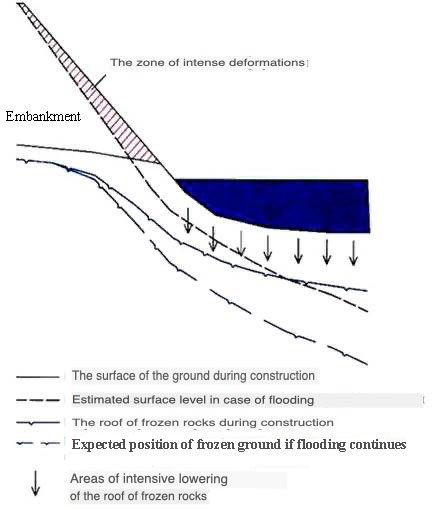
Fig. 4. Activation of deformations with increasing slope steepness embankments as a result of flooding [8] Stepwise subsidence of the main embankment site is associated with uneven thawing and precipitation of frozen soils in whole blocks with the formation of "steps" (Fig. 5).
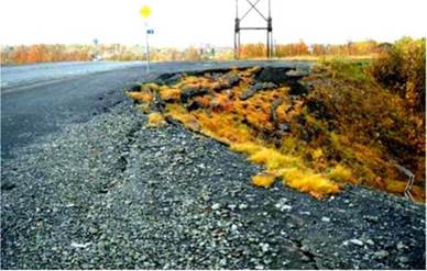
Fig. 5. Stepwise subsidence of the main platform of the embankment of the Norilsk – Talnakh highway [8] The steps can occupy a significant part of the main site. The difference in levels between the "steps" can reach 5 cm. Stresses caused by uneven precipitation of the base lead to the formation of cracks in the asphalt surface and its intensive destruction. The development of cracks at the junction of the slope and the main site will be facilitated by the specifics of seasonal freezing of embankments. The main feature of their seasonal freezing is the direction of the freezing front mainly from the main site. This causes the formation of significant (up to 20-25 ° C/m) temperature gradients during the initial freezing period. With such temperature gradients, frost-breaking cracks may form in the soil of the embankment. The direction of the freezing front from the main site during the freezing of bulk soils with a large amount of dusty fraction under conditions of small (from 0.3 to 5.0 ° C/m) temperature gradients at a depth of more than 3 m at the end of the cooling season can lead to the development of subvertical segregation ice layers. When they are thawed, vertical zones of decompression are formed, along which the soil is melted and sedimented. The freezing of embankments occurs both from above and from the side surfaces. This can lead to the formation of local pressure water zones with the subsequent development of heave mounds, intra-soil and surface ice, deforming both the road floor and the body of the embankments themselves (Fig. 6). 
Fig. 6. The bulge of heaving on the surface of the embankment [9] Formation of thermokarst subsidence in the area directly adjacent to the roadbed and partially under its shoulder. In areas of flooding, where in a number of places, due to the interception of surface runoff by an embankment structure, lakes of considerable size (from the first meters to the first hundreds of meters) are formed. Depending on the depth of the reservoir, its linear dimensions, time of existence, composition and iciness of soils, thermokarst subsidences of various sizes and intensity are formed (Fig.7), affecting 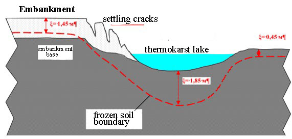
Fig. 7. The development of thermokarst in the area of the embankment of the Yamal railway at the site of flooding [10]. Stresses in bulk soils caused by uneven precipitation of the base lead to the destruction of the roadbed on highways. The scale of thermokarst subsidence, and, accordingly, the destruction of the embankment, increases with an increase in the ice content of the near-surface horizon of permafrost rocks (MMP), the thickness and duration of the water cover and the snow thickness in winter. The combination of highly acidic soils in the soils of the embankment base and flooding should be considered the most unfavorable factor for the construction of highways and other bulk structures. Figure 8 shows the features of the thermal effect of a cement-concrete paved highway (Tazovsky – Gaz-Sale road, Tazovsky district of the Yamalo-Nenets Autonomous Okrug) at the intersection of a polygonal swamp [11]. The width of the base of the road embankment is 20 m, the road is 12 m, the height of the embankment is up to 2.5 m. The temperature of the MMP for the research area is from -3 to -7 ° C. The analysis of geo-radar data showed that the main areas of lowering of the roof of the MMP are localized in roadside depressions. At the base of the embankment, there is a sharp (up to 2 m) decrease in the roof of the MMP, which is due to the runoff of moisture into the roadside depression, as well as the pulling out of polygonal vein ice. Directly under the road embankment, the MMP roof lies at a depth of up to 3 meters or more, that is, the permafrost roof is located within the natural depths of occurrence, only in some places decreasing by 0.3 m. This position of the frozen rock roof corresponds to a transitional high-temperature type of quasi-stationary state of the temperature field [1]. Probably, this specificity of the MMP roof is due to significant cooling of the road embankment being cleared of snow in winter and significant warming of the sandy soils of the embankment in summer. 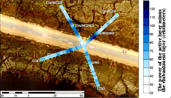
Fig. 8. Change in the depth of the MMP roof according to georadiolakation data on the Gaz-Sale–Tazovsky highway [11]
Formation of a layer of non-permafrost under the road. During the operation of highways in the area of permafrost distribution, especially in the southern regions of this region, when the capacity of thawed rocks exceeds the capacity of frozen ones. In this case, the "non-flowing permafrost" begins to form. Even in winter, there will always be a thawed horizon between the frozen layer and the upper boundary of the frozen rocks, which has a warming effect on the underlying frozen rocks all year round. In addition, this horizon is a channel for the redistribution of groundwater, especially if the rocks underlying the embankment are composed of coarse-grained material. Surveys of sections of the Amur highway sagging on the permafrost revealed that in more than 90% of cases there was water at the bases of the slopes of the road embankment. In some cases, the flow of water was carried out along and inside the sagging areas, including filtration through the body of the embankment at its base. The data from the control drilling showed that the depth of thawing of soils from the surface in the sections of the highway under consideration was more than 4.5 m at the end of August. The temperature of the frozen soils of the base 1.5–2.0 m below the thawing boundary was measured from -0.1 to -0.2 °C (Figure 4). According to the observations, the depth of freezing in these areas does not exceed 4.5 m (Fig. 9). [12] 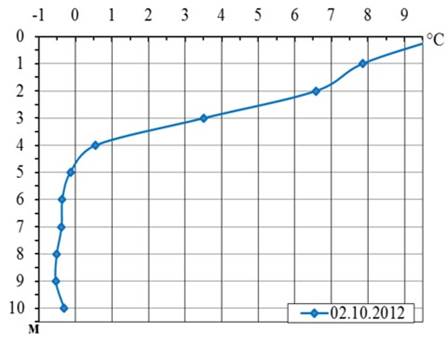
Fig. 9. Distribution of soil temperature at one of the surveyed emergency sites [12]. The ingress of water through the permeable soils of the lower part of the embankment to the frozen base causes a significant weakening of the strength characteristics of the soils composing it, especially dusty and clayey, both in interlayers and in fine-grained aggregates. At the same time, an increasing (excess) thermokarst thawing is gradually created due to additional, uncalculated heat transfer with water. Thixotropy also increases, i.e. the ability to vibro-liquefaction under the dynamic effects of thawed, soaked and not yet compacted base soils. The work performed allowed the authors to determine that the main cause of deformations in the emergency sections of the Amur highway is the "thawing" of unstable (high-temperature) permafrost rocks of the base [12]. In 2022, the authors of the article studied the permafrost conditions on the 288 kilometer of the Amur highway. The research was carried out at the site of the development of intensive subsidence of the roadbed (Fig. 10). 7 wells were drilled with a depth of 10 to 20 m with core sampling and subsequent thermometric observations in them. Based on the data obtained, an engineering geocryological profile was built (Fig. 11). The road section under study is located on the slope of the Olov River Valley, within the above-floodplain terrace. The surface is flat, with a slight slope towards the river, covered with grassy vegetation. The polygonal relief with re-vein ice is well expressed on the surface. The left (southern) section adjacent to the territory road is elevated relative to the right (northern) one (Fig. 10, 11). The discharge of surface water is carried out through a culvert laid in the body of the embankment. As a result of the conducted research, it was possible to identify some features of the influence of the highway on permafrost conditions. The territory under consideration is located near the southern border of the cryolithozone and is characterized by high negative temperatures. In the studied area, they do not fall below -0.5 ° C, the thickness of the seasonal thawing layer is 3.5-4 m. The construction of the road has significantly changed the permafrost conditions. 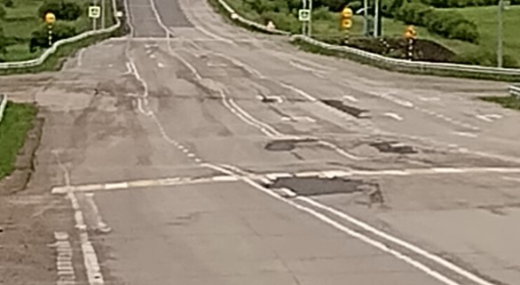
Fig. 10. Subsidence of the roadway on the 288 km section of the Amur highway. Photo by D. O. Sergeev 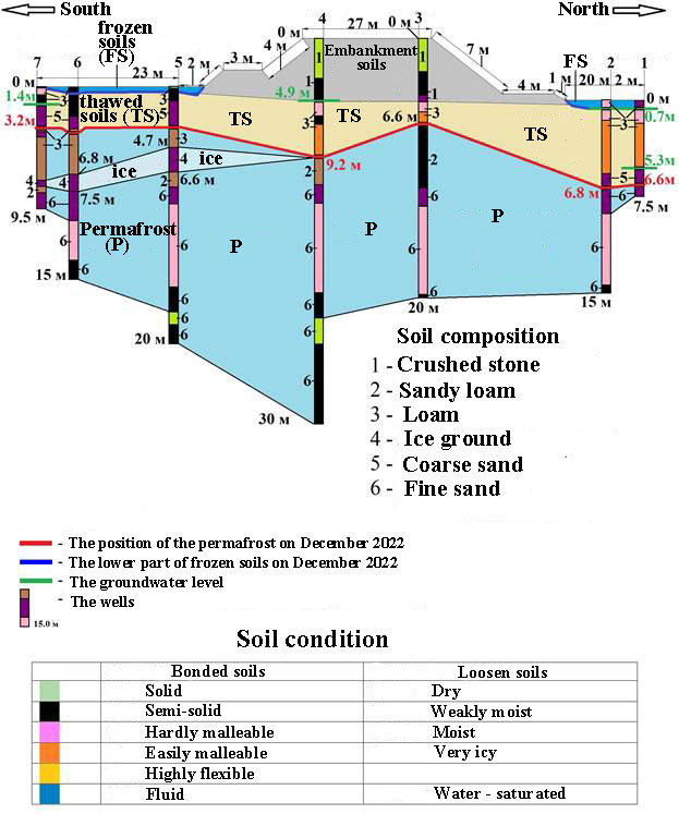
Fig. 11. Geocryological engineering profile on 288 km of the Amur highway (section with deformations of the roadway). Compiled by A. P. Kulakov Table 1. Temperatures in wells of engineering geocryological profile on 288 km of the Amur highway (section with deformations of the roadway). Drilling time, December 2023 | № The sensor | Square 2 |
Square 3 | Square 4 | Square 5 | Square 6 | | Temperature °C (depth m) | | 1 | -4,27(2) | -8,42(2) | -5,85(2) | -5,51(2) | -3,91(2) | | 2 | -2,75(2,5) | -6,39(2,5) | -4,64(2,5) | -2,62(2,5) |
-2,52(2,5) | | 3 | -1,01(3) | -4,08(3) | -3,1(3) | -0,82(3) | -1,03(3) | | 4 | -0,08(3,5) | -1,67(3,5) | -1,5(3,5) | 0,01(3,5) | -0,13(3,5) | | 5 | 0,01(4) | -0,08(4) | -0,08(4) |
-0,09(4) | -0,15(4) | | 6 | 0,05(4,5) | 0,16(4,5) | 0,3(4,5) | -0,19(4,5) | -0,13(4,5) | | 7 | 0,07(5) | 0,18(5) | 0,6(5) | -0,11(5) | -0,23(5) | | 8 | 0,03(6) |
0,11(6) | 0,92(6) | -0,25(6) | -0,29(6) | | 9 | 0,03(7) | -0,06(7) | 0,75(7) | -0,25(7) | -0,36(7) | | 10 | -0,06(8) | -0,17(8) | 0,3(8) | -0,36(8) | -0,36(8) | | 11 |
-0,08(9) | -0,19(9) | -0,04(9) | -0,32(9) | -0,36(9) | | 12 | -0,15(10) | -0,23(10) | -0,29(10) | -0,34(10) | -0,38(10) | | 13 | -0,15(12) | -0,3(12) | -0,3(12) | -0,38(12) |
-0,3(12) | | 14 | -0,13(14) | -0,31(14) | -0,25(14) | -0,38(14) | -0,4(14) | | 15 | -0,21(15) | -0,32(16) | -0,38(16) | -0,4(16) | -0,38(15) | | 16 | | -0,38(18) |
-0,28(18) | | -0,4(18) | | 17 | | -0,36(20) | -0,36(20) | | -0,5(20) | | 18 | | | -0,38(22) | | | | 19 |
| | -0,4(24) | | | | 20 | | | -0,42(26) | | | | 21 | | | -0,42(28) | | |
| 22 | | | -0,5(30) | | | In the adjacent northern part of the site, water flow is difficult. Here, along the road, surface reservoirs and moistened depressions formed, and re-vein ice began to melt (Fig. 2). 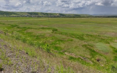
Fig. 12. Humidified northern section adjacent to the highway Photo by A.P. Kulakov There is no activation of exogenous processes in the southern section adjacent to the road (Fig. 13). The primary vegetation cover is preserved, there are no thermokarst depressions and open reservoirs expressed in the relief. 
Fig. 13. The section adjacent to the highway from the south. Photo by A.P. Kulakov The violation of surface runoff and the development of thermokarst affected the temperature distribution in the soils. In the northern, humidified area, positive soil temperatures can be traced to a depth of 8-9 m (sq. 2,3). In the southern section, no more than 3-3.5 m (5.6 sq.) thawed, that is, it did not exceed the capacity of the active layer. There is also differentiation in the temperature distribution in the soils under the highway. In the well drilled in the southern, more heated part of the embankment (square 4 in Fig. 11), the soil thawed more than 8 m. In the northern part, the thawing depth is about 6 m (square 3 in Fig. 11). Thawing of frozen rock under the embankment led to subsidence of the roadway, and its southern part is deformed more intensively than the northern one (Fig. 10). This is facilitated by the removal of an icy horizon (Fig.14), found in the immediate vicinity of the southern part of the embankment (square 5, Fig. 11). 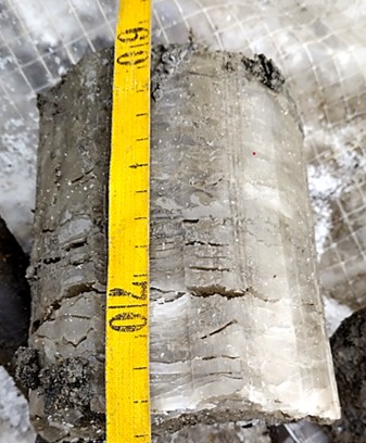
Fig. 14. Core from the icy horizon (square 5). Photo by D.O. Sergeev. The construction of the highway radically changed the structure of the frozen strata. A horizon of non-permafrost has formed under the seasonally frozen layer. From the moment of its occurrence, thawing of frozen rocks occurs throughout the year. Rocks of this horizon usually have reduced strength properties, they are often waterlogged, and serve as a transit zone for groundwater, both in summer and winter. The directional thawing of frozen rocks will last until they are completely thawed. During this period, deformations of various elements of the highway will be observed. The thermal effect exerted by the PTS examination on the high-temperature frozen layer will lead to its complete degradation. Measures to counteract this process can only weaken it, but not completely stop it.
A complex of dangerous processes The deformations of the roadbed discussed above are caused by the development of not one, but a whole complex of "chain" engineering geocryological processes and phenomena. Thus, in the poorly drained swampy bottoms of river valleys, characterized by the presence of strongly icy permafrost strata, the cause of the development of negative processes is often flooding of the upland part of the right-of-way as a result of violation of surface and intrasurface runoff by the earth bed. The resulting shallow lake, which is well warmed up in summer, causes intensive thawing of permafrost rocks and thermal subsidence reaching several tens of centimeters. A man-made talik has been forming under the lake for several years, and subsidence in the zone of its influence gradually captures the bases of the berm. Subsidence of the berm begins, and then of the roadbed itself. Unilateral subsidence from the upland side occurs in the body of the embankment, accompanied by erosive erosion and melting of the body of the roadbed. The intensity of thermokarst processes and mechanical deformation of the path is often initiated annually by the winter formation of heave mounds embedded in the roadbed, which contributes to the development of landslides and small landslides on the slopes. The total effect of the development of a chain of interrelated processes leads to the formation of deformations, which cannot be eliminated by lifting the path to the ballast due to the annual spreading of the embankment. An important indicator of the reaction of permafrost rocks to man–made changes in landscape conditions (and, accordingly, heat exchange) is the paragenesis of natural and man-made processes, which manifests itself in the fact that several processes begin to occur simultaneously at a certain time interval, each of which, having created conditions for the appearance of another at a certain stage of its development, does not complete itself. Because of this, there is often an increase in negative effects from the development of a chain of interdependent processes. Typical chains (series) of natural and man-made processes are shown in Table 2. Table 2. Typical natural and man-made paragenetic series of geocryological processes [13]. | № | Paragenetic series | | 1 | An increase in the average annual temperature and an increase in the depth of seasonal thawing of rocks ® flooding ® long-term thawing of rocks ® thermal sedimentation of rocks (or liquefaction of rocks with the acquisition of quicksand properties) ® subsidence of the Earth's surface + suffusion | | 2 | Increase in the average annual temperature of rocks with a transition through 0 °C ® long-term thawing of rocks ® thermokarst ® flooding + thermal erosion + solifluction | | 3 | Flooding of the surface ® thawing of permafrost rocks ® change in the level regime of groundwater ® frosty heaving of rocks + ice formation ® soil liquefaction during thawing ® splashes | | 4 |
Surface flooding ® thawing of permafrost rocks ® changes in the flow of surface and level regime of groundwater ® thermokarst + frosty heaving of soils + erosion + suffusion + microflows + microslides | In areas where there is a potential for the development of dangerous processes, it is usually difficult to determine the moment when dangerous manifestations are combined (i.e., a synergistic effect occurs). This is due to the probabilistic nature of changes in natural factors that trigger processes. However, taking into account the peculiarities of the dynamics of geocryological conditions in various zonal and regional settings, it can be expected that the processes develop most actively in the conditions of the marine climate in the territory of the distribution of dispersed ice-saturated sediments. Chinese experts, studying the permafrost processes on the Golmud-Lhasa railway, revealed the dependence of the intensity of the complex of dangerous processes on the height of the embankment and the exposure of its slopes (Fig. 15). 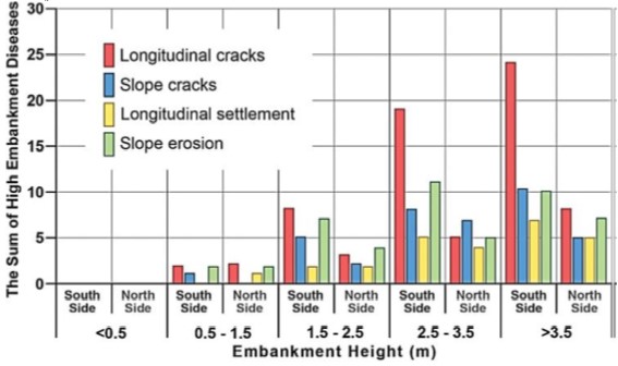
Fig. 15. The complex of dangerous processes in connection with permafrost on the Golmud-Lhasa road, depending on the height of the embankment during the first 30 years of study (according to Wang): the sum of dangerous processes on a high embankment (The sum of high embankment diseases), the height of the embankment (embankment height), longitudinal cracks (longitudinal cracks), cracks on the slope (slope cracks), longitudinal sediment (longitudinal settlement), slope erosion (slope erosion), north side (north side), south side (south side) [14] The considered groups of processes and their causative factors act on road objects located in the territories of permafrost distribution together, therefore the resulting negative effect is very significant. Assessment of violations and restoration measures on highways in permafrost conditions The reasons listed above lead to significant deformations of engineering structures and violate their operational characteristics. The consequence is the annual appearance of significant sections of roads requiring repair and, accordingly, an increase in the cost of their restoration. Let's look at this with a few examples. The Amur Highway runs in the southern part of the cryolithozone, characterized by high temperatures of permafrost rocks and deep seasonal soil freezing. In an interview with V.A. Shvetsov, director of the Far East Federal State Educational Institution, published on 02/10/2010 on the Rosavtodor website, it is noted that already in the year of completion of the Amur highway, 263 km (12.1%) were in need of major repairs, and about 400 km (18.5%) were in need of reconstruction. In 2012, the number of sections with violation of the roadway of such places reached 313 pcs., in 2013 – 394 pcs., in 2014 – 402 pcs., in 2015 – 504 pcs., in 2016 – 312 pcs. in 2017 – 284 pcs. in 2018 – 235 pcs., in 2019 -195 pcs. In 2020-2022, 27 sections with a length of 561.5 km were repaired [15]. The forms of manifestation of such sites are different, these are: subsidence of the roadbed, landslides and shifts, wide cracks, etc. Subsidence of the roadbed is the greatest danger. Since the commissioning of the entire road in 2010, the first subsidence began to appear on the section passing through the territory of the Trans-Baikal Territory in 2011 (Table 3). Table 3. The development of subsidence of the roadbed and the costs of their elimination on the Trans-Baikal section of the Amur highway Chita-Khabarovsk, km 0 – km 794 (741+588) in 2011-2013 (according to the data of the Federal State Budgetary Institution Uprdor "Transbaikalia") 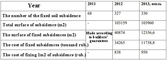
In 2014, restoration work and elimination of subsidence in the amount of 49 units were carried out, on an area of 166.65 thousand m2, with a length of 19 km, in 2015 - 2016 188 units, with a length of 52.6 km, in 2017 – 2018 20.305 km, in 2018 93.564 km, in 2019 91.69 km. Monitoring of the condition of the repaired sites showed that the work on laying the asphalt concrete layer does not radically change the situation. Attempts to ensure safe driving conditions by repairing the pavement do not bring results, the processes of thawing of permafrost rocks that began at the base of the roadbed continue. Drawdowns occur again 2-3 months after repair. The survey of roads and railways on the Norilsk - Talnakh section conducted by V.I. Grebentsov and V.A. Isakov showed that the deformations of the canvas in one form or another are characteristic of half of their length. Deformations have various forms and scales of manifestations and are mainly represented by sediments of the roadbed, cracks in the asphalt pavement and roadsides, erosion and subsidence of embankment slopes. Approximately for every 3 km of track, there is one section with stability violations that threaten traffic safety. A comparison of the results of the conducted route survey of the highway with the materials (data) of the asphalt pavement survey carried out in 2007 showed that, despite the repairs carried out in 2008, the number and area of the surface deformations increased. Large-scale deformations of the asphalt pavement, as a rule, were recorded in 2010 and 2011 in the same areas as in 2007. For smaller deformations (with an area of up to 5 m2), such inheritance is not observed. The researchers concluded that the cause of significant deformations in terms of area is not manufacturing defects during repairs, but a directional change in the geotechnical situation at the base of the roadway [6]. Of the 718 km of the Kolyma federal highway (R-504) surveyed in 2011-2012, 37 km were found to be negatively affected by cryogenic processes, of which: 29 km - ice, 8 km – subsidence [16].
E.A. Bedrin analyzed data on deformations of the roadbed of some highways and railways located in the cryolithozone. According to the report of the road department of the Chukotka Autonomous District, by 2000, more than 60% of Chukotka's highways needed reconstruction, since the height of their roadbed due to subsidence became twice lower than that laid down under the project, and 15% were already at "zero" marks and, under load from vehicles, continued to sink. The results of long-term operational surveys (since the 70s) of emergency permafrost areas of BAM, which by 1990 amounted to 3,627 places (including 60 in critical condition) over 2,240 km, showed that road embankments had the following precipitation: up to 200 mm/year and more (up to 500 mm) for the first time 18-20 years of operation; up to 40-50 mm/year in subsequent years. In 1992, the defectiveness of the roadbed amounted to 31% of the total length of the BAMA highway through permafrost. During the development of oil and gas fields (Urengoyskoye, Medvezhye, Yamburgskoye, Pestsovoye, Bovanenkovskoye, etc.) in the permafrost zone of the north of Western Siberia, rapid (in 3-4 years), massive destruction of the prefabricated pavement made of high-strength, reinforced reinforced concrete slabs designed for a 25-year maintenance-free service life was observed. The main reason for the premature mass failure of high-strength reinforced concrete slabs is the operational (uneven and excessive) precipitation of road embankments [17]. Organization of work on monitoring the condition of highways in the field of permafrost distribution The cryogenic processes discussed above begin to develop already during the construction of highways and continue during their operation. They are widespread, are the main destructive factor and are often not eliminated by ongoing repair work. Improving the quality of design and survey work and compliance with recommended technologies during construction do not significantly improve the situation. The complex of cryogenic processes is so diverse, and the synergistic effects of their interaction are so great that it is currently very difficult to predict the total deforming effect on the roadway within local areas. The lack of proper geocryological information often leads either to an underestimation of the danger of possible geocryological engineering processes and phenomena and the use of unreliable technical solutions and structures of road elements, or, conversely, to an overestimation of such danger and the use of unnecessarily expensive, time-consuming technical solutions and structures [18]. In these conditions, the most effective solution to the problem of ensuring the sustainable functioning of highways in the territory of permafrost is to create a system that ensures timely identification of hazards and the adoption of scientifically based measures to eliminate them. This system should include a number of procedures and organizational measures, such as: - identification of potentially dangerous areas where the destruction of the road is in the initial phase; - conducting additional geocryological engineering studies to identify hazardous processes; - development of projects for engineering and restoration work; - making managerial and financial decisions to ensure restoration work; - installation of control equipment to analyze the effectiveness of the work performed; - creation of a database that combines all information about deformations, conditions, properties, etc., geotechnical systems of highways obtained from various sources and the organization of information flows between all structural units engaged in engineering and geocryological monitoring. Collection, storage and distribution of information The survey of engineering structures and man-made impact zones is used to assess the condition of engineering facilities, characterize the intensity of development and areal distribution of engineering geocryological processes and phenomena, as well as to select (assign) locations for stationary observations. It can be carried out remotely (aerial and space photography, aerial visual observations, video) and by ground-based methods (field survey of engineering facilities and adjacent landscapes in the zone of man-made influence). The design features of the studied engineering facilities determine the specifics of the indicators that affect their technical condition and are to be established during the survey. On highways, this is the condition of the roadbed, the observed deformations of the embankment, the characteristics of the right-of-way and adjacent sections. The frequency and timing of the survey depend on the stage of development, the established dynamics of man-made loads and the prevailing types of developing deformations. In general, during the construction period, when the most dynamic change in geocryological conditions occurs due to the increase in man-made loads and impacts, often accompanied by the development of dangerous deformations, the survey is carried out more often, as well as during the initial period of operation. It should be borne in mind that one of the most important tasks of geocryological engineering monitoring is to identify dangerous geodynamic processes at the initial stage of their development.
One of the main issues in the development of the concept of monitoring the GTS highway - permafrost is the choice of ways to obtain information about its current violations during operation. Two areas can be distinguished: continuous automated (online) monitoring, and monitoring based on periodic inspections and surveys. Despite the attractiveness of the first direction (obtaining direct measurements in automatic mode with any necessary frequency), there is one significant drawback in its use. Highways are long objects (up to several thousand kilometers) that run in a variety of climatic, geological, geocryological and hydrological conditions. Landscape diversity under constant anthropogenic load associated with the operation of the highway leads to the emergence of new and strengthening of existing exogenous processes that negatively affect engineering structures. If we take into account the direct and inverse relationships between these processes, then their destructive effect can be multiplied. In these conditions, it is impossible to place a sufficient number of automated stations that provide the necessary control over the functioning of the highway. Currently, it is a well-established global practice to conduct periodic inspections and surveys, followed by an analysis of the results obtained and, if necessary, issuing recommendations on the need for repair or restoration measures. When monitoring in accordance with this approach, the data obtained during inspections and surveys will sufficiently reflect the state of the facility at the current time and at the same time will identify dangerous areas where additional research is needed. At the same time, periodic inspections may not be sufficient to monitor the technical condition of unique and particularly complex structures (bridges, overpasses, embankments or recesses) operated in extreme conditions. In these cases, the monitoring system should be continuous and automated. The system for monitoring the technical condition of road structures should include a number of basic subsystems: - automated monitoring of the most important objects, ensuring continuous measurement of selected parameters; - monitoring in the mode of periodic inspections and surveys, including the collection of primary information, the identification of the most dangerous sites and the organization of their in-depth examination; - an information block that provides the collection, processing, storage of monitoring data and the issuance of information on the condition of highway facilities; - geodynamic model showing the change in the state of the GTS highway (engineering structures underlying the soil massif) over time, taking into account both long-term trends and short-term local impacts. A set of works for monitoring cryogenic processes on highways in conditions of permafrost Engineering geocryological monitoring is carried out in areas with intensive development of negative cryogenic processes or predisposed to their development. In addition, it allows you to select the location of stationary monitoring posts. At the stage of operation of highways, engineering geocryological monitoring makes it possible to register changes in geocryological conditions, to forecast the development of adverse cryogenic processes. Thus, identify dangerous areas where deformations of the roadway, embankments and other elements of the road infrastructure occur or are expected. Monitoring is carried out in the mode of periodic visits using remote and ground-based methods, as well as at organized stationary observation posts. During the monitoring process, the following cryogenic processes are monitored: - Thermokarst. Observations of thermokarst in identified potentially dangerous areas of the thermokarst process, as well as in areas of underground ice development, are organized in order to detect signs of thermokarst and conditions leading to its activation in the right-of-way. The objects of monitoring are subsidence and surface reservoirs that occur on the surface of road structures and the right-of-way of the highway. In areas of active development of thermokarst processes, the depth and area of depressions and thermokarst lakes are measured, the temperature regime of water and bottom sediments is measured, and the rates of coastal retreat (thermal abrasion) are measured. - Frosty heaving of soils. Observations on potentially dangerous sections of the highway are organized in order to detect signs of heaving, determine the speed and amplitude of heaving depending on climatic factors and man-made impacts. The objects of monitoring are the flood-prone sections of the highway, the area of distribution of heaving soils in the upper horizon, their composition and humidity. Observations include monitoring the temperature of rocks, installation of depth gauges and reference points, repeated geodetic surveys, laboratory examination of soil properties. - Ice it up. Observations on potentially ice-prone areas are organized in order to detect signs and conditions of ice formation in intersected valleys of rivers and streams and at groundwater outlets in valleys. The object of monitoring is the ice-prone areas of valleys on the highway, the thickness of ice bodies, the area of ice clearings, the lifetime of ice (seasonal and perennial) and their source of nutrition (groundwater or river water). - Thermal erosion processes. Observations in areas subject to thermal erosion processes are conducted in order to determine the intensity of their manifestations. Regular monitoring of possible rock erosion is organized within the right-of-way. The objects of observation are steep slopes of interfluves and river valleys, gullies, furrows, actively growing ravines that threaten the erosion of the embankment of the highway. The research includes: identification of newly formed erosive forms; measurements of the parameters of erosive forms (depth, width) with reference to reference points; instrumental surveying (tacheometric, leveling, etc.) to determine the magnitude of the displacement of the tops of erosive forms. - Kurums. The object of monitoring is the smoke-prone slopes on the highway. The methods of observation include repeated geodetic work on marked rock fragments, the opening of curum bodies with pits.
- Solifluction. Observations at the sites of solifluction development are organized in order to detect signs of soil displacement on the slopes crossed by the highway. - Landslide processes. The object of monitoring is landslide-prone slopes on the highway, landslide bodies and their parameters. - Avalanche-talus processes. The object of monitoring is the avalanche-talus slopes within the right-of-way of the highway. According to the survey materials, 4 groups of sites are allocated: - sections of the GTS with deformations of structures and with foundation soils affected by dangerous engineering and geocryological processes; - areas of the zone of man-made impacts with activation or neoplasm of geocryological processes that are dangerous for the operation of structures; - potentially dangerous areas, within which there are conditions for the occurrence of dangerous engineering and geocryological processes; - other areas with relatively favorable dynamics of the natural environment. Organizational solutions The monitoring system, no matter how perfect it is, cannot be effectively used without an appropriate organizational system that includes: - the operating organization responsible for obtaining primary information from automated monitoring posts and in the mode of periodic inspections and sending it to the information processing center, as well as making a decision on organizing additional research in the most dangerous areas; - a scientific (scientific and production) organization providing scientific support for monitoring work, developing recommendations for the prevention or elimination of negative processes, conducting research at sites specified by the operating organization, forecasting changes in permafrost conditions at repaired sites (all research materials are sent to the information center); – a design organization that, based on the available information from periodic surveys and data from an automated complex, develops a design solution to eliminate violations in selected areas; - an information center where all received information is flocked, processed and stored. The massive work currently underway to repair significant sections of highways built in the area of permafrost distribution is, in fact, adaptive. Their goal is to bring the parameters of these structures in line with changing geocryological conditions. Often these works are carried out without appropriate scientific support, which reduces their effectiveness. This leads to an increase in costs, while the goals set, as shown by the materials discussed above, are not achieved. Organizations engaged in the operation of highways in the field of permafrost propagation need to develop a corporate system of integrated measures that control the interaction of natural geocryological (including climate dynamics) and man-made factors in order to minimize the possibility of adverse consequences. This system will ensure the development of an adaptive model for the functioning of highways in the field of permafrost distribution, which includes a number of consistent procedures for making managerial decisions at all structural levels. The adaptation model assumes the adjustment of management decisions, as well as the mode of operation of the existing facility, aimed at ensuring its sustainable operation in case of changes in landscape and climatic conditions. Adaptation measures include consistent procedures for assessing changes in the transformation of permafrost rocks, forecasting further climatic changes and the state of MMP, developing a mechanical model and assessing the bearing capacity of rocks taking into account changes in their condition, and finally making organizational decisions. The ultimate goal of adaptation measures is to provide scientific information support to decision makers in order to respond in a timely manner to changing or expected changes in environmental conditions that negatively affect the functioning of the highway infrastructure in the cryolithozone. To plan and manage adaptation, it is necessary to solve the following tasks: - to include adaptation in the development policy and investment plans of the organization operating the highway; - to determine the methodology for obtaining and analyzing information about the past and expected regional changes in climate and geocryological conditions and the possible consequences of these changes for production facilities; - to determine the criteria for the need for adaptation measures at the regional and facility levels; - to propose criteria for the selection of priority adaptation strategies at the regional and facility levels. These criteria may include cost-benefit ratio, reliability criteria, flexibility, etc.;
- identify the areas for which the formation of regional adaptation programs is necessary; - to develop methods and technological techniques used to select effective and maximally economical measures for engineering protection and/or compensating measures at the facility level; - to develop a system of reporting and information interaction between participants of adaptation programs; - define the areas of responsibility and authority for participants in adaptation programs; - identify the resources needed to develop and implement adaptation programs; - to define criteria and indicators of the effectiveness of adaptation programs and activities. During the monitoring, changes in the GTS are recorded. The reasons for any changes are related to any processes that cause them, so it is important to trace the entire chain of events that determine negative changes on the highway. To do this, consider the sequence of stages of interaction between technical and natural components in the formation of GTS. At the stage of surveys and design of the highway, the most stable sections are selected, where the geological environment is in a conditionally quasi-stationary state. For the permafrost distribution area, this quasi-stationary state will be determined by climatic and landscape conditions. At the same time, the main indicators will be temperature, power, iciness, power of the active layer of frozen rocks. The construction of highway facilities (mainly the roadbed) introduces significant changes, forming non-equilibrium conditions at the border of the man-made and natural components of the GTS. If the design solution is chosen correctly, then after a short time the GTS will come to a quasi-stationary state. Most often, stabilization is not observed, and the GTS of the highway, as well as the adjacent sections, begins to transform and collapse. Several stages of the negative development of the GTS should be distinguished. In the area of permafrost distribution, the lithogenic component has a negative temperature and contains ice. If this component is in a non-equilibrium state, either a decrease in temperature or an increase in temperature will occur. The first will lead to an increase in the strength properties of soils and does not pose a danger to the highway. The second can lead to an increase in temperature to the values of phase transitions. As long as temperatures are in the negative range, activation of thermodenudation processes is not observed. When the soil temperature of the phase transition region is reached, the melting of frozen rocks begins. Since that moment, the development of a complex of thermodenadution processes such as thermokarst, thermoerosion, solifluction, and thermoabrasion has been observed. In turn, the combination of these processes leads to the destruction of road structures: subsidence of the roadbed and the associated formation of cracks, thermal erosion of the embankment, the formation of sedimentation cracks on the slopes of the embankment. Several stages of the development of processes that destroy highway facilities should be distinguished: the creation of non-equilibrium conditions at the boundary of man-made highway facilities and underlying frozen rocks; a change in the state of the frozen massif (with an increase in temperature in the region of negative values) with local insignificant external manifestations of thermal denudation processes; the development of thermal denudation processes within the permissible deformations of highway facilities and adjacent territories; the development of unacceptable deformations and destruction of objects of the highway and adjacent territories. It is necessary to choose your own set of observations for each stage. Monitoring the compliance of design solutions and the actual interaction of the technical component with the environment. It is performed on the basis of long-term complex observations, in stationary observation posts located on selected sites with typical conditions and is aimed at assessing the behavior of highway objects in real conditions, as well as the direction and rate of change in the state of the components of the natural environment. Observations are carried out in hospitals and in the mode of periodic visits. Monitoring of areas where there are no deformations of highway objects, and changes in the right-of-way are already being observed, observations are carried out in the mode of periodic visits and fixation of changes. Monitoring of areas where deformations of highway objects and in the right-of-way are observed, observations are carried out in the mode of conducting special engineering and geological studies (geophysics, drilling, thermometry in wells, etc.). Creation of a single database for all types of monitoring. Adding a list of monitoring activities to the list of activities carried out by the operating organization with the development of regulations and their financing. Inclusion in the list of ongoing activities for monitoring scientific support works with the involvement of third-party specialized organizations with the development of regulations for these works and their financing. The existing experience in the organization of engineering and geological monitoring of GTS operated in the territories of permafrost distribution
Currently, in the Russian Federation, a number of organizations are successfully using integrated engineering and geocryological monitoring systems. These include, first of all, Gazprom, Transneft and a number of others. In them, the work on collecting and analyzing information and developing design and technical solutions within the framework of geotechnical monitoring is integrated into the overall organizational structure. Organization of geotechnical monitoring (GTM) Gazprom is distinguished by its complexity and consistency. It takes into account and coordinates technical and managerial decisions, stages of the life cycle of objects, hierarchy in the organization of work, ranking of information transmission, and features of interaction between various departments. Consider some basic principles of monitoring organization. Accounting for the stages of the life cycle of objects Each stage of the life cycle differs in the types, levels and intensity of man-made impacts on the natural component of the GTS and the reaction of permafrost rocks to these impacts. Accordingly, the organization of information flows will also differ. At the stage of the background assessment, the natural and geological features of the territory of the planned location of engineering facilities (the stage of design and survey work) in natural, undisturbed conditions are evaluated based on the results of engineering and geological surveys, scientific research, cartographic and other works, landscape studies. At the stage of construction of engineering facilities, changes in engineering-geological, geocryological, hydrological and other conditions are recorded immediately after the completion of construction and installation works. The initial stage of operation of engineering structures lasts from 3 to 5 years, depending on the depth of the changes that occurred during the construction period and the man-made impact on the GTS (types and depth of man-made violations and their predicted reaction to these man-made violations). At this stage, a time interval is conditionally fixed, after which the consequences of the construction period sharply decrease, and the degree of influence of the existing engineering facility increases. Typical types of effects at this stage are direct thermal, mechanical, and less often chemical loads on the thickness of the MMP, leading to a violation of the temperature regime of the soils of the bases, a change in their deformation and strength properties and, as a rule, to a decrease in bearing capacity. The stage of intensive operation of engineering facilities is diagnosed by adapting geocryological conditions to man-made disturbances of their condition and the formation of the GTS proper as a single complex and association of natural and engineering components interacting with each other. Hierarchy in decision-making At the level of operating organizations, measures are being taken to prevent and eliminate the consequences of the development of dangerous exogenous processes (thermal erosion, thermokarst, solifluction, etc.). Technical solutions aimed at improving technologies and methods of construction and operation of engineering facilities are being developed at the level of research and design organizations. At the level of the parent organization, expertise is carried out, technical management solutions (TUR) are coordinated and approved, aimed at ensuring the operational reliability and safety of engineering facilities. Availability of feedback At the object level, the information obtained during routine observations undergoes primary processing, is aggregated, analyzed for reliability and transmitted to the organization's GTM service. The GTM service adjusts the modes and frequency of observations, followed by the transfer of information about changes to the level of the facility where technological changes are carried out. The ranking of information transmission according to the degree of danger to objects is divided into several levels: planned, operational, extreme, emergency. With the planned nature of information transmission in the GTM system, the frequency of information transmission is determined by the project and corresponds to the standard operating mode of the facility. In the operational mode, information is transmitted to higher levels in case of detection of the development of dangerous processes, identification (or prediction of the occurrence) of abnormal situations.
In extreme conditions associated with the development of emergency situations at engineering facilities, information is immediately transmitted to higher levels of the GTM system, to the management of operating organizations, In case of emergency situations, information is transmitted to the territorial and regional services of the Ministry of Emergency Situations of the Russian Federation. Transneft Research Institute LLC has developed a software package for the geoinformation system "Monitoring of the linear part of the main oil pipelines". The geotechnical monitoring system provides for continuous automatic data collection and periodic monitoring of parameters. Twice a year, specialists measure the temperature of permafrost using thermometric wells, carry out in-line diagnostics to determine the spatial position of the oil pipeline, control the planned altitude position of objects in the linear part. These measures make it possible to increase the accuracy of determining the spatial position of the pipeline, calibrate calculation models based on natural data and, accordingly, reduce the risks of pipeline deformations. The route is also being surveyed from aircraft using innovative aerial laser scanning technology and ultra-high resolution digital aerial photography. The results of measurements and surveys are entered into an information database, where they are systematized. The information obtained is the basis for a comprehensive analysis of the current technical condition of the oil pipeline facilities and the formation of a forecast of its changes under planned operating conditions. GIS Monitoring makes it possible to ensure the efficiency of making managerial and technical decisions aimed at trouble-free operation of main pipelines. The successful creation of an engineering geocryological monitoring system in the organizations under consideration is due to several reasons. From the very beginning, leading scientific organizations with extensive experience in the study of frozen rocks were involved in its organization. Integrated monitoring systems were created as corporate divisions and were integrated into the overall information and management structure of organizations. This made it possible to combine the collection of information, its processing, accumulation, scientific support with financial and managerial decisions. The situation is different with regard to highways. Thousands of kilometers of roads have already been built on the territory of Transbaikalia, Western and Eastern Siberia, and Taimyr. Practice has shown that from the beginning of operation and in subsequent years, road structures began to deform and collapse everywhere, especially in the territories near the southern border of the cryolithozone. The sharply increased volume of paved roads construction in permafrost areas is not accompanied by appropriate scientific and organizational measures. In order to accelerate the development of a monitoring system for highways operated in the territory of permafrost distribution, it is absolutely necessary to take into account the experience of such work in the country. Conclusion Currently, there is a significant gap between the ongoing intensive construction of highways in the Arctic zone of the Russian Federation and the relevant regulatory framework that takes into account the specifics of the interaction of engineering structures and frozen rocks. This applies primarily to the regulations governing the conduct of engineering and geocryological monitoring. The observed large-scale deformations of the roadbed on various highways operated in the field of permafrost distribution are associated not only with the shortcomings of prospectors, the shortcomings of builders, or the mistakes of designers. They reflect the complex of problems arising from the interaction of natural and man-made components of the formed GTS. Various combinations of permafrost conditions and applied technical solutions cause a variety of manifestations of cryogenic processes that negatively affect the functioning of road facilities. Engineering and geocryological monitoring of highways in the field of permafrost propagation should be carried out on the basis of a comprehensive program that includes technological, scientific, methodological, managerial, and other measures. The monitoring system, no matter how perfect it is, cannot be effectively used without an appropriate organizational structure, including: - the operating organization responsible for obtaining primary information from automated monitoring posts and in the mode of periodic inspections and sending it to the information processing center, - an information center where all the information received is flocked, processed, stored and distributed among other departments; - a scientific (scientific and production) organization providing scientific support for monitoring work, developing recommendations for the prevention or elimination of negative processes, conducting research at sites specified by the operating organization, making a forecast of changes in permafrost conditions at repaired sites; – a design organization that, based on the available information obtained during periodic surveys, data from an automated complex and materials obtained during additional research, develops a design solution to eliminate violations in selected areas; - the decision-making center for prioritizing the direction of work and their financing. In the Russian Federation, in a number of organizations, there is a positive experience in creating successfully functioning standards for engineering and geocryological monitoring, which, taking into account the specifics of the GTS of highways, could be used.
References
1. Isakov, V. A. (2015). TEMPERATURE REGIME IN THE BASE OF ROAD ON PERMAFROST. VESTN. ISCO. UN-TA, SER. 5. GEOGRAPHY, 3, 25-34.
2. Torgovkin, Ya. I., Shestakova, A. A., & Vasilyev, N. F. (2020). SPATIAL ANALYSIS OF THE DISTRIBUTION OF FROST CONDITIONS ON THE FEDERAL HIGHWAY P504 “KOLYMA” (YAKUTSKY SECTION). Geoinformatics, 3, 46-52.
3. Maslov, A.D. (2005). Fundamentals of geocryology: textbook. Maslov, A.D., Osadchaya, G.G., Tumel, N.V., & Shpolyanskaya, N.A. Ukhta: Institute of Management, Information and Business.
4. Babkin, E.M., Babkina, E.A., Leibman, M.O., Khairullin, R.R., & Khomutov, A.V. (2022). Monitoring changes in the relief of polygonal peatlands adjacent to the Zapolyarnoye-Tazovsky highway. Problems of the Arctic and Antarctic. T. 68. No. 4. 384–405. Retrieved from https://doi.org/10.30758/0555-2648-2022-68-4-384-405
5. Tikhonravova, Ya. V. (2019). Features of the structure of polygonal ice wedges in the north of the Gydan Peninsula and the Pur-Taz interfluve: abstract of thesis. ... candidate of geological and mineralogical sciences. Yakutsk. 23 p.
6. Grebenets, V.I., Isakov, V.A. DEFORMATIONS OF HIGHWAYS AND RAILWAYS AT THE NORILSK-TALNAKH SECTION AND METHODS OF COMBATING THEM. Cryosphere of the Earth, vol. XX, 2, 69–77.
7. Kondratiev, S.V. (2016). Deformations of the Trans-Baikal part of the federal highway "Amur" Chita-Khabarovsk in areas of icy permafrost soils: causes and ways to solve the problem (using the example of crossing the Chichon stream). Abstract of Ph.D. Irkutsk Institute of the Earth's Crust.
8. Isakov, V. (2012). Main types and causes of deformation on roads and railways in the Norilsk industrial region Tenth International Conference on Permafrost Science (TICOP): Resources and risks of regions with permafrost in a changing world. Volume 3. Tyumen. Pechatnik. 207-211.
9. Bogdanov, A.I., Kvashuk, S.V. (2022). Analysis of the operation of a railway track in conditions of low-drainage marshes and high-temperature permafrost (using the example of the bypass area of the Bureya Reservoir). Arctic and Antarctic, 1, 95-108. doi:10.7256/2453-8922.2022.1.37649
10. Comprehensive survey of the condition of in-field roads at the Bovanenkovo and Kharasavey gas condensate fields. Scientific and technical report of LLC Research and Production Enterprise "GEOSYSTEM" 2003.
11. Kaverin, D.A., Sudakova, M.S., Khomutov, A.V., Khairullin, R.R., Fakashchuk, N.Yu., & Pastukhov A.V. (2022). Application of ground penetrating radar to assess the influence of a highway on the depth of permafrost in polygonal swamps of the North of Western Siberia. Arctic and Antarctic, 2, 1-12. doi:10.7256/2453-8922.2022.2.37964 Retrieved from https://nbpublish.com/library_read_article.php?id=37964
12. Bedrin, E. A., & Dubenkov, A. A. (2014). ANALYSIS OF THE CAUSES OF EXCEEDING NORMAL DEFORMATIONS ON HIGHWAYS IN HIGH-TEMPERATURE FROST CONDITIONS (BASED ON THE RESULTS OF MONITORING THE AMUR HIGHWAY). SibADI Bulletin, issue 3(37), 48-51. Retrieved from https://nbpublish.com/library_read_article.php?id=37649
13. Development of technological regulations for the construction of experimental sections and carrying out geotechnical monitoring during the construction of the new Obskaya – Bovanenkovo railway line. (2008). Report on contract, 2/08. LLC "PNIIIS-RESEARCH. Moscow.
14. Harris, S. A. (2020). Geocryology. Characteristics and use of permafrost. T. II. Harris, S. A., Brushkov A., V., Cheng Guodong. Moscow. Berlin: Direct-Media.
15. Retrieved from http://xn--90aecdnbadn7basfee.xn--p1ai
16. Guly, S.A., & Prell, N. (2013). ANALYSIS OF THE SOURCES OF THE CAUSES OF SOME CRYOGENIC PHENOMENA ON THE FEDERAL HIGHWAY R-504 "KOLYMA". Bulletin of MADI, 3(34).
17. Bedrin, E. A. (2011). Determination of directions for ensuring the stability of road subgrades in the permafrost zone. Bulletin of the Siberian State Automobile and Road Academy. Issue, 2(20), 15-21.
18. Kondratyev, V.G., & Kondratyev, S.V. (2013). PROTECTION OF THE FEDERAL ROAD “AMUR” (CHITA-KHABAROVSK) FROM HAZARDOUS ENGINEERING GEOCRYOLOGICAL PROCESSES AND PHENOMENA. Engineering Geology, 5, 40-47.
Peer Review
Peer reviewers' evaluations remain confidential and are not disclosed to the public. Only external reviews, authorized for publication by the article's author(s), are made public. Typically, these final reviews are conducted after the manuscript's revision. Adhering to our double-blind review policy, the reviewer's identity is kept confidential.
The list of publisher reviewers can be found here.
The subject of the study, according to the author, is the peculiarities of the organization of engineering and geocryological monitoring of highways operated in the territories of permafrost distribution. The methodology of the study is not specified in the article, but based on the analysis of the article, it can be concluded that the cartographic method with elements of remote sensing, methods for analyzing the composition of soils and frozen rocks, as well as the analysis of literary data. Judging by the illustrative material, the author undertook expeditionary field research methods, followed by desk processing. The relevance of the topic raised is unconditional and consists in obtaining information about the genesis and geomorphological features in the territories of permafrost distribution where thousands of kilometers of modern paved roads have been built. The existing methods of design, construction and operation do not provide the necessary parameters for the reliability and safety of these engineering structures. The destruction continues in the process with repeated repetition and after repair work in all regions of Russia (Western Siberia, Taimyr, Yakutia, Transbaikalia). with different geocryological conditions. The author's research helps to understand the mechanism of reaction to changes in weather and climatic conditions and the operation of transport routes. The scientific novelty lies in the attempt of the author of the article, based on the conducted research, to conclude about the complex of problems arising from the interaction of natural and man-made components formed by a special geotechnical system. It is concluded that various combinations of permafrost conditions and applied technical solutions cause a variety of manifestations of cryogenic processes that negatively affect the functioning of road facilities. Style, structure, content the style of presentation of the results is quite scientific. The article is provided with rich illustrative material reflecting the process of deformation in soil and soils. The author has studied in detail from the beginning of operation and in subsequent years road structures with widespread deformation, especially in the territories near the southern border of the cryolithozone. In order to accelerate the development of a monitoring system for highways operated in the territory of permafrost distribution, it is absolutely necessary to take into account the experience of such work in the country, which makes the results presented by the author of the article very interesting. The article is richly illustrated with a variety of visualized forms of information from tables and graphs to diagrams and photographs. The bibliography is very exhaustive for the formulation of the issue under consideration, but does not contain references to normative legal acts and methodological recommendations on the existing positive experience in creating successfully functioning standards for engineering geocryological monitoring, which takes into account the specifics of the GTS of highways. The appeal to the opponents is presented in identifying the problem at the level of available information obtained by the author as a result of the analysis. Conclusions, the interest of the readership in the conclusions there are generalizations that made it possible to apply the results obtained. The target group of information consumers is not specified in the article.
Link to this article
You can simply select and copy link from below text field.
|
|


