|
MAIN PAGE
> Back to contents
Arctic and Antarctica
Reference:
Vasil'chuk A.C., Vasil'chuk Y.K.
Possibility using carbon-to-nitrogen ratio as a criterion for palsa and lithalsa distinguishing
// Arctic and Antarctica.
2023. № 3.
P. 52-72.
DOI: 10.7256/2453-8922.2023.3.44176 EDN: VKRSQW URL: https://en.nbpublish.com/library_read_article.php?id=44176
Possibility using carbon-to-nitrogen ratio as a criterion for palsa and lithalsa distinguishing
Vasil'chuk Alla Constantinovna
Doctor of Geography
Leading Research Fellow, Laboratory of Geoecology of the Northern Territories, Faculty of Geography, Lomonosov Moscow State University
119991, Russia, g. Moscow, Leninskie Gory, GSP-1, 1,, geograficheskii fakul'tet, NIL geoekologii Severa

|
alla-vasilch@yandex.ru
|
|
 |
Other publications by this author
|
|
|
Vasil'chuk Yurii Kirillovich
ORCID: 0000-0001-5847-5568
Doctor of Geology and Mineralogy
Professor, Department of Landscape Geochemistry and Soil Geography, Lomonosov Moscow State University, Faculty of Geography
119991, Russia, Moscow, Leninskie Gory str., 1, of. 2009
|
|
vasilch_geo@mail.ru
|
|
 |
|
DOI: 10.7256/2453-8922.2023.3.44176
EDN: VKRSQW
Received:
29-09-2023
Published:
19-10-2023
Abstract:
The palsa and lithalsa are reliable indicators of the presence of permafrost, especially on the its southern border. The subject of the study is the consideration of the C/N ratio in the peat of the palsa and the litter and humus horizon of the lithalsa as a criterion for the separation of the palsa and lithalsa. The palsa near the Yeletskaya village in the Bolshezemelskaya tundra and the lithalsa in the Southern Transbaikalia near the Preobrazhenka village and in the valley of the Sentsa in the Eastern Sayan are considered. The history of the study of lithalsa and palsa in Russia at the beginning of the twentieth century is considered also. It was found that the nitrogen content in the surface layers of the lithalsa (0.45-1.73% in the valley of the Sentsa River and 0.47-2.01% near the Arachley Lake) is approximately in the same range as in the surface horizons of the palsa, regardless of the permafrost region. The results of the carbon and nitrogen content determining, as well as their ratios in the peat cover of the palsa are summarized. In contrast to lithalsa, the carbon content in the peat horizons of the palsa and flat-hummock peatlands is many times higher than the values obtained for both surface and buried organic horizons of the lithalsa. The value of C/N less than 13 has not been recorded for the peat cover of palsa, this indicator for lithalsa never exceeds 10-12.
Keywords:
permafrost, palsa, lithalsa, Holocene, peat, carbon, nitrogen, Bolshesemelskaya tundra, Sayan, Transbaikalia
This article is automatically translated.
You can find original text of the article here.
Introduction Palm peatlands on the scale of the biosphere contain a significant carbon reserve (C), therefore, their dynamics in the biosphere have important consequences for the global carbon cycle, the dynamics of bumpy peatlands, as well as nitrogen and carbon content indicators in the Arctic and Subarctic arouse increased interest among researchers in connection with the assessment of greenhouse gas emissions and changes in the productivity of tundra landscapes, and also with the fact that the heave mounds – palza and litalza - are a reliable indicator of the presence of permafrost rocks, especially on the southern border of their distribution. However, the uncertainties of estimates of carbon dynamics at different time scales, different approaches require further study of these complex natural systems. According to the definition given in Wikipedia: palza is peat mounds (hills) with a permafrost peat-mineral core, litalza is mounds (hills) formed under the influence of frost in areas of permafrost with mineral—rich soils, where a lens of perennial ice has formed in the soil. Definitions from the international geocryological dictionary-reference[1]: palm - peat mounds (hills) of permafrost, the core of which consists of alternating layers of segregation ice, peat or mineral soil material. The explanation of the term minerogenic palsa states that S. Harris[2] described the sequence of stages of development of finger-shaped hills developed in mineral soils in the Fox Lake area (Yukon), for which he proposed the name "litalza". He suggested that a new name is needed, since the processes of heat and moisture transfer in mineral soils differ from those in peat soils. Domestic geocryologists had not previously isolated litales, and in cases when mineral mounds were encountered, they were called bumpy marys, burial mounds, etc. [3,4,5]. Similar in structure to the litalz are the hillocks-tabelers, widely distributed in the intermountain basins of the Altai. It must also be admitted that the term litalza did not immediately take root in English-language literature. Other terms have been used for a long time: “minerogenic fingers”[6], “mineral fingers”[7], “finger-like hillock”[2], “cryogenic mounds”[8] and “mineral permafrost hillock”[9]. And only after the work of A. Pissar[10], the ice-mineral mounds prefer to be called lithalsa. The first to use the term litalza in relation to the Russian ice-mineral mounds of Ivakhan and colleagues studied in the valley of the Akkol River in Altai[11]. Yu.K. Vasilchuk first met relatively low mineral mounds (litalza up to 1 m high located directly between the railway tracks) in paragenesis with palza near the village. Khanovey, near Vorkuta in 2002, however, did not pay due attention to this and recorded it only in a 2016 publication: "Heaving mounds - both peat and mineral - are frozen..."[12]. The reason for a more attentive attitude to the mineral heave mounds was a detailed study of ice-ground deposits in the thickness of a mineral permafrost mound (litalza) in the valley of the Sentsa River in Western Buryatia [13,14]. The exposed ice-ground deposits were the cores of injection–segregation type bulges – litalza - and formed in the late Holocene. Recognition of heave mounds and their type: palza, litalza or pingo-bulgunniakhi is not an easy task, since their morphology and morphometry are quite close. In both cases these are convex mounds with a height from 0.5 to 5-8 m (rarely 10 m or more - in pingos) of rounded or oval (elliptical) outline in plan (usually the first tens of meters in diameter. An important criterion for separation is the presence of peat cover, often thick (up to 5 meters or more) at the finger (Fig. 1), and its often almost complete absence in the sections of litalza (Fig. 2) and pingo. 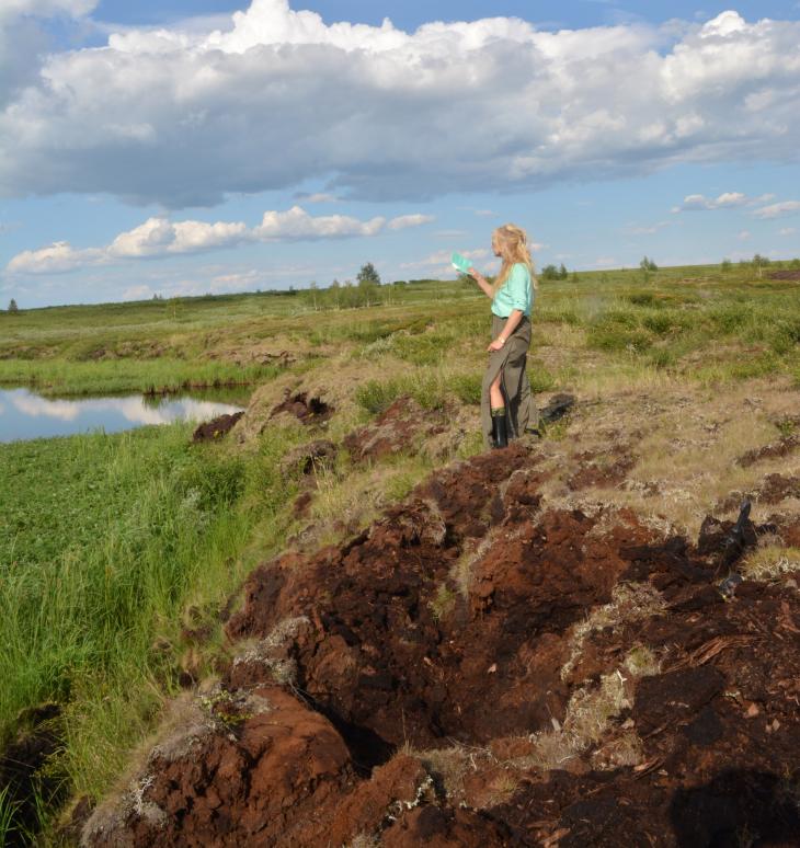
Fig. 1. A finger covered with a thick layer of peat, near the village of Yeletsky. Photo by Yu.K. Vasilchuk 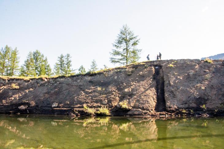
Fig. 2. Litalza in the valley of the Sentsa river. Photo by J.Y. Vasilchuk The objects of this study are litalza in Southern Transbaikalia and Eastern Sayan, as well as palza in the Bolshezemelskaya tundra. The main objective of the study is to assess the similarities and differences in the distribution of nitrogen and carbon in these cryospheric objects. Climatic characteristics of the study areas Palza at the village of Yeletsky. The studied array of [15-17] typical fingers (see Fig. 1, Fig. 3) located in the European part Polar?Ural (67°02' s.w. and 64°12' v.d.) near the village of Yeletsky, 52 km south of Vorkuta. The climate is subarctic, characterized as unstable with heavy snowfalls, blizzards and frosts. The period of negative temperatures is from October to March. According to the data of the Yeletskaya weather station in the interval 1959-2022, the minimum average annual temperature was recorded in 1998 -8.3?C; the average value of this indicator is -4.9?C, the maximum is -0.8?C in 2020. The lowest average daily temperature was observed in February 1966 ? 30 °C, and February 1998 -29.6 °C; the average daily January temperature was -19.7 °C, the average temperature of the three winter months -18.2 °C. The maximum average daily temperature of +18.3 °C was recorded in July 2007, the average July temperature was +13.7 °C, during the observation period there was no recorded average daily July temperature below +7.6 °C, which was observed in 1997, the average temperature of the three summer months was +10.5 °C. 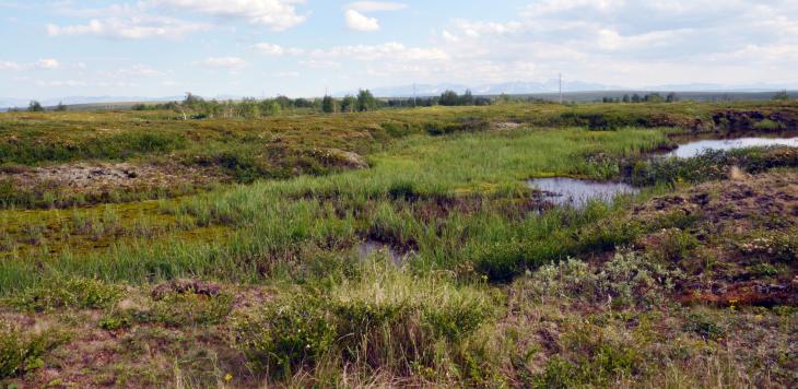
Fig. 3. Palza at the village of Yeletsky. Photo by Yu.K. Vasilchuk Litalza in the valley of the Sentsa river. The studied litalza massif on the left bank of the Sentsa River (52?39.827' N, 99?29.858' E) is located within the lowered lake basin in the southeast of the Eastern Sayan on the Okinsky plateau. The climate within the Okinsky Plateau is sharply continental. According to the nearest weather station Orlik (52°50's.w. 99°82' in.D. altitude above sea level - 1375 m -http://www.pogodaiklimat.ru/history/29998.htm ): the average annual temperature for the period 1934-2022 is in the range from -2.7 °C to -6.6°C, the average January temperature is -24.5 °C (from -33.2 to 17.1 °C), the absolute minimum is -46.9 °C, the average temperature of the warmest month of July is 13.4 °C (from +11.1 to +16.3 °C), the absolute maximum is +35.8 °C. The average annual temperature of frozen rocks varies within -2.1 ... -8.5 °C, sometimes rising to -0.5, -1 ° C. The seasonally thawing layer on the interfluvial spaces has a thickness of 1.0-1.5 m, reaching 3.5 m on the southern slopes. On the surface of the first terrace of the Sentsa River (absolute height 1387 m), large castalzas with a height of 4 to 7-9 m were studied and drilled. The temperature of the soils of one of the largest lithals (7 m high) according to the thermometry of a deep well is -2.1 ° C (at a depth of 10 m), and -1.0 ° C (at a depth of 20.4 m). Litalza at the village . Preobrazhenka in the Trans-Baikal Territory are common in the coastal zone of the lake.Arachley (52 °13c.w., 113 °48 v.d.) in the Beklemishevskaya basin (a tectonic depression of the Trans-Baikal type). The climate is characterized as sharply continental. The area is characterized by large daily and seasonal temperature fluctuations, a high level of solar radiation (the annual amount of the radiation balance is 30.6 kcal /cm2). According to the nearest weather station Burgen): the average annual temperature for the period 1937-2022 is in the range from -1.5 °C to -6.2 °C, the average value is -3.5 °C, the average January temperature is -27.2 °C (from -34.8 to -22.3 °C), the absolute minimum is -52 °C.the average temperature of the warmest month of July is +17.1 °C (from +13.5 to +20.3 °C). the absolute maximum reaches +34 °C. The duration of the frost-free period is 70-90 days, with a very late transition of stable temperatures through +10 ° C. The duration of the growing season is about 130 days. 350-380 mm of precipitation falls in this area per year. Of these, the growing season accounts for from 280 to 320 mm (precipitation is most abundant in July and August). In winter, precipitation ranges from 1 to 5 mm, so the height of the snow cover does not exceed 10-15 cm, on wooded ridges and ridges - 150 cm. Permafrost rocks are noted on the northern slopes, the greatest MMP capacity is noted in the falls. Methods for measuring the content of organic carbon (C) and nitrogen (N) To determine the content of organic carbon (C,) and nitrogen (N), samples of peat and soil horizons with a volume of about 1-0.5 cm3 were taken from the sections of the palza and litalza. The samples were freeze-dried for two days, then crushed in an agate mortar and dried again at 60 °C for 2 hours. The samples were placed in foil capsules, weighed with an accuracy of 5 digits. Measurements of the percentage of nitrogen and carbon were carried out in the Laboratory of Landscape Geochemistry of the Department of Landscape Geochemistry and Soil Geography of the Geographical Faculty of Lomonosov Moscow State University. The measurements were carried out on the VARIO EL III V4.01 CHNS analyzer 20.Aug. 2002, Elementar Analysen systeme GmbH, Germany. Sulfanylic acid (Merck) was used as a standard with values of N = 8,090%, C = 41,610%. Results Litalza at the village . Preobrazhenka. Litalza were studied by O.E. Maksimova[18] on the territory of the Ivano-Arakhlei reserve 300 m south of S.Preobrazhenka in the Trans-Baikal Territory (52 ° 13c.w., 113 ° 48 v.d.). O.E. Maksimova, with the assistance of D.M.Shesternev, described in detail two litals: one 2.5 m high (Fig. 4), the other 1.2 m high. 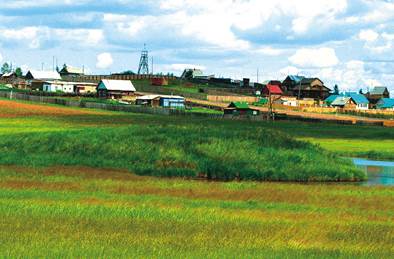
Fig. 4. Litalza near the village. Preobrazhenka. Photo by O.E.Maksimova For temperature observations, D.M. Shesternev and colleagues drilled a well at the top of the largest 2.5-meter finger. In its section from top to bottom are opened: 0 – 2 cm – turf; 2 – 25 cm – gray-brown powdery slightly torn sandy loam with a large number of roots; 25 – 41 cm – gray-brown powdery slightly torn sandy loam with a small number of roots; 41 – 63 cm – dense brown powdery loam with the inclusion of roots; 63 – 93 cm – very dense brown loam; 93 – 100 cm – very dense gray-beige loam. The whole soil is very dry, from the surface the hillock is covered with a dusty slightly detached sandy loam, underlain by loam. Two pits were laid in a small hillock, the soil in the section of the hillock is wet and strongly torn off. In the section from the surface there is also a sandy loam, which turns into loam below. In the well at the top of the largest heaving hill, negative ground temperatures are traced to a depth of 4.5 m on the slope of the hillock (Fig. 6) and to a depth of 7.8 m at its top. Three pits were laid in a large hillock: in the upper, middle and lower parts (Fig. 5). 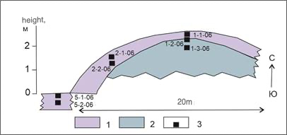
Fig. 5. The profile of the largest hillock in the system of heave mounds in the lake basin. Arachley next to D. Preobrazhenka, Transbaikalia (according to O.E.Maksimova[18]): 1 – gray-brown detached sandy loam with roots 2 – brown powdery loam, 3 – sampling points 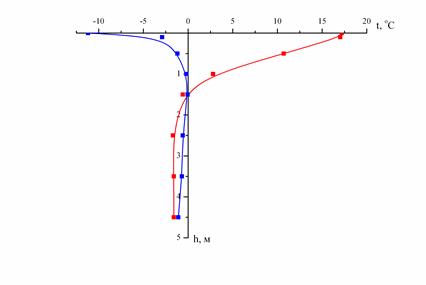
Fig. 6. The graph of the temperature distribution in the litalz section on its slope near the lake.Arachley, Trans-Baikal Territory (from O.E.Maksimova[18]). Cryogenic structure of hillocks Litalza in the valley of the Sentsa river. On the surface of the first terrace of the Sentsa River (absolute height 1387 m), large castalzas with a height of 4 to 7-9 m were studied and drilled. The roof of the MMP is fixed at a depth of 0.85-1.5 m (Fig. 7). The upper part of the sections of the studied litals is represented by light brown sandy loam, which is underlain by bluish-gray loam at a depth of 6.3 m. The apparent iciness of the soil increases from a depth of 1.35 m . Below, the section is composed of ice-ground with basal, sometimes layered large-leaf, cryotexture. In numerous interlayers and lenses with a capacity of 3-5 cm, the ice is transparent with bubbles of a rounded (diameter 0.5-1.0 mm) and elongated shape. In places, the ice is white and opaque. At a depth of 6.3 m, a clear contact with bluish-gray sandy loam was recorded, which lies to a depth of 8 m. From a depth of 8 m, the sandy loam is replaced by bluish-gray loam, contains layers of transparent ice (up to 5-6 cm). The thickness of the loam interlayers is 6-7 cm, their cryotexture is massive. 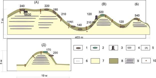
Fig. 7. Litalz profiles in the Sentsa River valley. According to Vasil'chuk et al.[19] with additions: 1 – lenses of buried peat; 2 – decomposed wood; 3 – wood residues (roots, branches); 4 – 14 years old, cal. years ago; 5 – litalz index; 6 – the boundary of the seasonal-thawed layer; 7 – lake-river frozen loam; 8 – seasonal-thawed layer; 9 – ice core litalz. 10 – sampling points for the content of C and N. Palza in the Bolshezemelskaya tundra near the village of Yeletskaya. Within the convex-bumpy massif in the area of the village of Yeletsky (67°16's.w., 63°39' v.d.), heave mounds with a height of 1.5 to 5 m were studied in detail. Samples were taken from sections located in various geomorphological positions: on the peaks, slopes and at the foot of the finger, as well as in the hollows on the tops of the hillocks. As an example of a typical finger for this localization, an incision of a bulge with a height of 2.5 m (18El?VC.) is given. The maximum depth of thawing at the top of the hillock (at the end of September) was 0.65 m. The 18El?VC finger had a flat (and not convex, like most of the mounds on this array) surface. This hillock in the marginal part is eroded by a lake, peat was selected from the exposed peat wall for 14 C dating, as well as for determining the carbon and nitrogen content (Fig. 8). 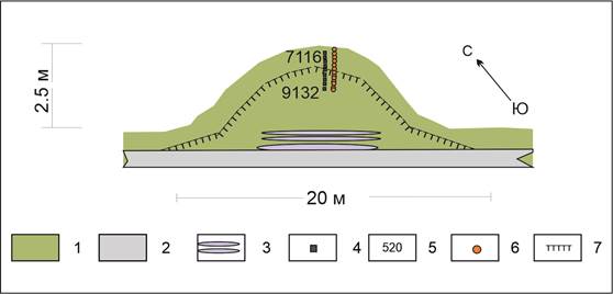
Fig. 8. Profile of the 18El?VC finger near the village of Yeletskaya: 1 – peat; 2 – gray loam; 3 – ice core; 4 – sampling points at 14C; 5 –14C age, cal. years ago; 6 – sampling points for the content of C and N; 7 –the boundary of the seasonal melt layer. Organic carbon (C,) and nitrogen (N) content Litalza in the valley of the Sentsa river. Litalza on the surface of the first terrace p .Senets are characterized by the following indicators: in the litter-peat and humus soil horizons, the nitrogen content (N) is 0.45?1.73%, the average value is 0.83%, the carbon content (C) is 2.52-11.56%, the average value is 6.86%, the C/N ratio is in the range of 6.2?12.9, the average value is 9.33 (Table. 1). Table 1. Carbon and nitrogen content of litter-peat and humus soil horizons of litalza in the Sentsa river valley | № | Field number | horizon and depth of selection, cm |
N,% | C,% | C, mol | N,mol | Ca/Na | | 1 | Jse-16-2 | About 0-3 | 0,80 | 5,64 | 0,47 | 0,06 | 8,24 | | 2 | Jse-16-3 | O 0-3 | 0,70 | 5,65 | 0,47 | 0,05 | 9,46 | | 3 | Jse-16-9 |
O 0-3 | 1,33 | 11,56 | 0,96 | 0,1 | 10,13 | | 4 | Jse-16-14 | O0-3 | 0,47 | 2,52 | 0,21 | 0,03 | 6,24 | | 5 | Jse-16-16 | About 0-3 (10) | 0,73 | 5,20 | 0,43 |
0,05 | 8,27 | | 6 | Jse-16-22 | TO 0-27 | 1,73 | 11,25 | 0,94 | 0,12 | 7,57 | | 7 | Jse-17-2 | AU 0-5(14) | 0,47 | 3,94 | 0,33 | 0,03 | 9,77 | | 8 | Jse-17-4 | Aurig 0-28 | 0,86 |
6,85 | 0,57 | 0,06 | 9,30 | | 9 | Jse-17-5 | Av 0-2 | 1,01 | 11,23 | 0,94 | 0,07 | 12,92 | | 10 | Jse-17-7 | O0 - 3 | 0,51 | 5,22 | 0,43 | 0,04 | 11,88 | | 11 |
Jse-17-13 | 0-2 | 1,27 | 11,30 | 0,94 | 0,09 | 10,41 | | 12 | Jse-17-14 | O0-2 | 0,45 | 4,02 | 0,34 | 0,03 | 10,52 | | 13 | Jse-16-21 | AY 0-5(16) | 0,83 | 5,96 | 0,50 |
0,06 | 8,350 | | 14 | Jse-16-15 | AT 0-3 | 0,82 | 5,30 | 0,44 | 0,06 | 7,55 | At the foot of the litalz and in the hollow at the top of the litalz, the highest values of carbon and nitrogen content are recorded, the minimum values are characteristic of the slopes. Low-power lenses of mesophilic buried peat have been traced in the sections of the lithals. For lenses of buried peat, the following are characteristic: the N content is 0.60?2.28%, the average value is 1.31%, the C content is 4.15-26.14%, the average value is 12.68%, the C/N ratio is in the range of 7.78–13.76, the average value is 10.58. In the upper parts of the mold, buried peat lenses are practically not found, peat in in the process of heaving, it was destroyed. The highest values of carbon and nitrogen content were noted in the peat lenses at the foot of the litalz, the minimum values on the slopes. The nitrogen and carbon content in buried peat is generally higher than in litter and humus horizons. In the illuvial horizon, the N content is 0.30–0.89%, the average value is 0.54%, the C content is 2.19-5.64%, the average value is 3.73%, the C/N value is in the range of 5.85–11.34, the average value is 8.48. Inclusions of coal and wood of pyrogenic origin found in the illuvial horizon are characterized by a high carbon content of 55.61% and an average nitrogen content of 0.6% for litalz sections. The soil-forming rock on the site with litalza is represented by lacustrine-alluvial deposits, mainly medium-powdery loams with an aggregated skeletal microstructure, the clay content of the loam is 20-30%[20]. The nitrogen content is approximately the same as in the illuvial or bedding horizons N – 0.31-1.60%, the average value is 0.54%, the carbon content also does not differ much from the overlapping horizons. C – 1.3-9.06%, average value 3.77%, C/N value in the range 4.30-11.15, average value 8.36[21]. Litalza at the village . Preobrazhenka. Geochemical characteristics of litalz near Lake.Arachlei is close to the characteristic of litales in the Sentsa River valley in terms of nitrogen content, the carbon content in the litter horizon is much higher. In a layer of detached sandy loam with roots, the nitrogen content (N) is 0.47?2.01%, the average value is 1.26%, the carbon content (C) is 2.27-21.60%, the average value is 11.43%, the C/N ratio is in the range of 4.8-10.8, the average value is 8.3. Note that the content of both nitrogen and the carbon content in the 1.2–meter hillock is noticeably reduced compared to the higher 2.5-meter litalza, the average value of C/N for the 2.5-meter litalza is 10.0, and for the 1.2-meter hillock - 6.03 (Table 2). Table 2. The ratio of carbon to nitrogen in the litalza section near the lake.Peanuts | Field number |
| Depth, cm | N,% | C,% | Ca/Na | | 1-1-06. OM | The top of the litalza is 2.5 m | 0-20 cm | 2,01 | 21,60 | 10,75 | | 1-2-06. OM | 40-60 cm | 1,41 | 15,19 | 10,77 | | 2-1-06. OM | Litalza slope 2.5 m | 0-20 cm |
1,49 | 15,07 | 10,11 | | 2-2-06. OM | 30-50 cm | 1,10 | 9,19 | 8,35 | | 3-1-06. OM | The top of the litalza 1.2 m | 0-20 cm | 1,53 | 12,27 | 8,02 | | 3-2-06. OM | 20-40 cm | 0,84 | 4,40 | 5,24 | | 4-2-06. OM |
30-50 cm | 0,47 | 2,27 | 4,83 | In the surface layer of the 18El?VC finger located on the periphery of the drained lake basin, the values of ?13 C vary narrowly from -27.77 to -29.50%, the average value of ?13 C is -28.61% (Table 3). Table 3. Carbon content, nitrogen isotopic composition of carbon in the 18El?VC finger | Field No . | Sampling depth, cm | ?13C, % | N,% | C,% | Ca/Na | Calibrated median age by 14C, years ago | | 18El?VC/19 | 0.1 | 28,43 | 3,326 | 34,783 | 13,07 | |
| 18El?VC/20 | 0.3 | 28,36 | 3,946 | 46,467 | 14,72 | 7116 | | 18El?VC/21 | 0.5 | 27,84 | 3,256 | 47,123 | 18,09 | 7658 | | 18El?VC/22 | 0.7 | 27,77 | 2,09 | 52,03 | 31,12 |
7832 | | 18El?VC/23 | 0.9 | 28,04 | 3,486 | 45,059 | 16,16 | 8110 | | 18El?VC/24 | 1.1 | 29,28 | 4,475 | 55,364 | 15,46 | 8163 | | 18El?VC/25 | 1.3 | 28,13 | 3,106 | 48,105 |
19,36 | 8748 | | 18El?VC/26 | 1.5 | 28,63 | 3,072 | 47,954 | 19,51 | 9132 | | 18El?VC/27 | 38?40 | 28,25 | 3,309 | 53,421 | 20,18 | - | | 18El?VC/28 | 45?50 | 28,85 | 3,666 |
53,46 | 18,23 | - | | 18El?VC/29 | 50?64 | 29,36 | 3,813 | 54,676 | 17,92 | - | | 18El?VC/30 | 65?68 | 29,15 | 3,478 | 54,976 | 19,76 | - | | 18El?VC/31 | 68?78 | 29,50 |
3,535 | 55,058 | 19,47 | - | | 18El?VC/32 | 78?82 | 28,88 | 1,777 | 29,475 | 20,73 | - | | 18El?VC/33 | 82?85 | - | 1,332 | 1,105 | 1,04 | - |
In peat, the maximum value of ?13 With -27.77% corresponds to a local minimum of nitrogen content of 2.09% and a local maximum of carbon content of 52.03%, as well as a maximum value of C/N of 31.12, possibly peat from this interval corresponds to the mesothelm – the boundary layer between acrotelm and catothelm, since below this layer the roots of modern vegetation during field the studies practically did not meet. At this level, the absolute peak of the values of the C/N ratio is 31.12. The nitrogen content is in the range of 1.777-4.475%, the average value is 3.309%. The carbon content is 29.48-55.36%, the average carbon content is 48.43%, while the minimum value falls on the peat layer bordering the underlying loam. The transition from thawed peat to frozen peat at a depth of 0.4 m is not marked by changes in the studied indicators. In the loam underlying peat, the carbon and nitrogen content is reduced, the C/N index is close to one. The degree of decomposition of peat did not affect the isotopic composition of peat and the nitrogen and carbon content. Analysis of the obtained radiocarbon dating of the finger of the massif near the village of Yeletskaya shows that peat accumulation in some locations began at the very beginning of the Holocene, about 11 thousand cal. years ago, and about 9-8 thousand cal. years ago, peat accumulation occurred, most likely, already on the entire area of this massif, judging by the fact that the bottom peat in all mounds has an age of 9.1-8.2 thousand cal. years ago. Discussion History of the study of litalza and palza in Russia
At the beginning of the last century, Russian researchers identified mineral heave mounds, a number of researchers – N.I.Prokhorov, O.I.Kuzeneva, A.N.Levitsky, V.S.Dokturovsky and N.V.Kvashnin-Samarin [3, p. 73], who observed heave mounds in the Upper Aegean Basin, in the western part of the Amur Region and in the basin of the Mamyn river, it was believed that the formation of mounds is due to the ability of the quicksand under the influence of gases or when it moves over the uneven surface of permafrost rocks, to lift, swell and even break through the upper soil horizons. S.L.Kushev[4] in the summer and autumn of 1933 investigated bumpy areas with peat and mineral heave mounds in the southern part According to S.L.Kushev, V.V. Stratonovich for the right bank of the Zeya River between pp. Information about the heave mounds on permafrost marys, in the Ogoronskaya basin and in the valley of the upper reaches of the Dep. river. Information about heave mounds on permafrost marys is given by V.V.Stratonovich for the right bank of the Zeya River.Bomnak and Tok, P. Rippas – for the valley of the R.Dep, V.S.Dokturovsky – for the valley of the R.Burrows (he even compiled a botanical map showing the areas of the greatest distribution of bumpy mares), Kryukov – for the Selemdzhino-Unminsky district. S.L.Kushev[4] pointed out that the distribution of heave mounds on marsh marys is very extensive: from the valley of the river Unma, the left tributary of the Selemdzhi River, bumpy mari spread up the river.Selemdje, enter the valley of its left tributary of the Byssa river, pass into the pp basin. Nora and Mamyn, the right tributaries of the Selemdzhi River, then into the basins of the middle and upper reaches of the Dep River and its left tributaries, mainly Ninni and Tungala, and the right – V. Dzhugdagin. To the north of the Tukuringra and Jagda ridges, bumpy mari are widespread in the Upper Mesian Basin and further west – in the basins of pp.Vranta, Unakhi, Ilikan, Upper Giluy and Tynda. Even further to the west, within Transbaikalia, the bumpy Mari can be traced approximately to the Nerchi River[4]. Typical bumpy mari are developed on the flat swampy peaks of the hummocks of the southern part of the Upper Mesian basin. Numerous heave mounds of the most diverse shapes, either in the form of correctly rounded ovals, or ramified elevations in different directions, have different sizes in length and width (from a meter or more), reaching a height of 0.5-1.0 m. In places, on the slopes of some mounds, there are swollen cracks (up to 2-5 cm wide), passing tortuously and more or less parallel to the line of the sole of the bumps. On the tops and slopes of the hillocks there are larch, less often pine and birch, the lower parts of some trunks have acquired an arcuate shape, the trees are tilted in different directions at different angles ("drunken forest"). The base of the bumpy mares and the mounds themselves are composed of silty-powdery, heavy, medium and light loam. The depressions between the mounds are filled with waterlogged dark peat-silty material with a thickness of up to 0.8-1.2 m[4]. The roof of permafrost rocks has a wavy occurrence, the reverse of the surface of the microrelief of a bumpy swamp. Frozen rocks under the mounds lie at a depth of 1.8-2.5 m, between the mounds, in depressions – by 0.80-1.20 m, and under the mounds the roof of permafrost rocks is in most cases 15-50, sometimes 75 cm lower than under the depressions. S.L.Kushev[4] gave a scheme for the formation of a convex bulge of heaving – a hillock- the burial ground. Primarily, in his opinion, small bumps are formed during the winter freezing of isolated moistened soil lenses, in which significant hydrostatic stresses develop. The bumpy Mar was studied by A.N.Tolstov[5] in the southern part of the cryolithozone (60-80 km northeast of its southern border), in the area of the middle course of the Bureya River, on the local watershed located 5 km east of it. The entire watershed is covered with a bumpy marya with a rare larch forest and with dense shrubby vegetation (cowberry, hemlock, blueberry, yernik). A dense moss cover (sphagnum) is developed between the mounds, and in some depressions it is saturated with water, in others a free water mirror is marked. When opening the mounds with trenches, the presence of permafrost rocks at a depth of 1.8 m was established. In addition, a large number of workings (sounding wells and pits) made in 1942-1943 confirmed the presence of permafrost strata with a capacity of 20-45 m. The convex mounds in the studied area had the appearance of hills with flat tops, with a diameter of 1.5 to 4 m and a height of 0.2 to 0.8 m and even up to 1.2 m (exceeding the west), they are more often called burial mounds. The tops of the hillocks in most cases were dry with mineral soils protruding to the surface. Humidity during observations at a depth of 0.5 m ranged from 27% (the northern edge of the hillock) to 48% (the center of the hillock) and at a depth of 1 m – from 16% (the northern edge of the hillock) to 44% (the center of the hillock). The lowest temperatures in the center of the hillock at a depth of 2.5 m were -0.5 °, and in the west, at the same depth -0.75 ° C [5]. The thickness of the ice slots in the sections of the mounds reached 2-2.5 cm, and the most icy were the soils near the sole of the seasonally thawed layer. Based on the received materials, A.N.Tolstov[5] concluded that the process of formation of burial mounds in natural conditions proceeds very slowly - for many decades. This is indicated by 120-150-year-old sabre-curved larch trees growing on mounds. The bumpy mar is confined to areas of surfaces composed of clay and loamy soils with slopes of less than 0.02, since in the presence of such slopes, a sufficiently rapid runoff of precipitation is not provided and water penetrates into the ground. The burial mounds on the studied site of the bumpy mari had the appearance of mounds with flat tops with a diameter of 1.5 to 4.0 m and a height of 0.2 to 1.2 m (exceeding the mineral bottom of the depression). The thickness of the active layer on the bumpy mari fluctuated under the depressions in the range from 0.75 to 1.25 m and under the mounds in the range from 1.6 to 2 m. The mineral soil composing the actual body of the hillock is drier in relation to the soils of its peripheral parts (i.e. lying in the depressions). Peat of the highest capacity was recorded under the southern depressions with tongues elongated under the mounds. A.N.Tolstov[5] suggested that burial mounds are formed due to soil heaving and hydrostatic stress. Carbon and nitrogen in palza and litalza According to the generalization of the results of determining the carbon content in organic matter in 268 peat cores from 215 sites located north of 45 degrees S.[22]: in peat formed by sphagnum moss, the carbon content on average is 42 ± 3% (standard deviation) for peat in which sphagnum mosses are absent - 51 ± 2%, on average for the peat of the northern peatlands, the carbon content in organic matter is 49 ± 2%. The nitrogen content is lowest in sphagnum peat (0.7 ± 0.3%) and highest in herbaceous vascular plants (1.7 ± 0.6%), the average value is estimated at 1.2 ± 0.7%. Based on these figures, it is also possible to estimate the average carbon-to-nitrogen ratio (C/N) in boreal peatlands of 45.3. The geochemical characteristics of the litalza (see Tables 1, 2) and palza (see Tables 3, 4) arrays are somewhat different.
A comparison of the nitrogen and carbon content in the litalza soil cover and the palza peat cover demonstrates both common features and differences. The nitrogen content in the surface layers of the lithals (0.45-1.73% in the valley of the Sentsa River and 0.47-2.01% near the lake.Arachley) is approximately in the same range as in the surface horizons of the finger, regardless of the region of the cryolithozone. For example, in the Igarka area, the nitrogen content in the peat cover of the palm is (0,37-3,26%)[23,24], in the Bolshezemelskaya tundra near the village . The nitrogen content in the peat cover of the palm is 1.2–2.9%[25]; and in the province of Quebec, the average nitrogen content in the peat on the surface of the palm is 1.8%[26]. In the peat of a flat-hummock swamp in the northern taiga of Western Siberia, the nitrogen content also averages 0.67%[27]. In the palm massifs in the north of Sweden, the nitrogen content is 0.7-3.7%[28]. It is obvious that the nitrogen content in the surface horizons of soils and peatlands in the permafrost development zone is in a rather narrow range. But unlike litalz, the carbon content in the surface horizons of the palz and flat-edged and polygonal peatlands is many times higher than the values we obtained for both surface and buried organic horizons of the litalz soil cover (Table 4.) Table 4. Carbon content, nitrogen value of Ca/Na in the palm arrays of the Northern hemisphere | The region of development of the Palza or Palza plateau | Nitrogen,% | Carbon,% | Ca/Na | source | | Davva, Sweden 68°27.8470's.w., 20°54.4184' v.d., | 1-3,7 | 19,4-48 | 13,2-38 | Hichens-Bergstr?m, Sannel [28] | | Riba, Sweden, 68°28.6469's.w., 21°00.1786' v.d. | 0,7-2,8 | 20-50 | 25-40 | | Laxev,
Norway 70°07.2509' s.w., 24°59.7747' w.d. | 1-2,2 | 21-56 | 20-48,6 | | Karlebot, Norway 70°07.2314' s.w., 28°28.4917' w.d. | 1,2-2,2 | 32-53 | 20-35 | | Keutukeinu, 69°00'43" s. w. 23°02'37" v. d. Norway Peat palza Ice palza | 0,6-2,9 1,2-3,1 | 38.3-48.9 21.4-49.1 | 16-65 15-18 | Wetzel, Fleige, Horn[29] | | Stordalen Sweden 68? 210 S. S., 18? 490 V.D. | | | 19-90 | Kr?ger, Leifeld, Alewell[30] | |
Storflaket Sweden 68? 21's. w., 18? 49' vd. | | | 20-99 | | Tornetrex(68? 21's. w., 18? 49's.d.) Sweden | | | 50-120 | | Skaluwaara (69°49?13 s. w., 27°9?47 v.d.) Finland | | | 26-29 | Palmer, Horn[31] | | Hanymei (63°43' s. w. 75°57' w. d.) | 0.7-1.0 | 48-64 | 50-72 | Lim et al.[27] |
| Zotino (60°04? s. w., 89°23?v.d.) Russia | 0.35-3.86 | 23.3-58 | 13-129 | Prokushkin, Novenko et al.[23] | | Igarka (67°31? s. w., 86°38?v.d.), Russia | 0.37-3.26 | 17-54.7 | 14-134 | | Seida River Bolshezemelskaya tundra (67°00-67°20 s.w., 61°40-63°00 v.d.) Russia | 1.2–2.9 | 35 - 50 | 20-25 | Pastukhov, Kaverin[25] | | Selwyn Lake 59°53? s.w., 104°12? s.d. Canada | 0.2-0.5 | 42.2 - 44.9 | 82 - 240 |
Sannel, Kuhry[32] | | Oz.Ennadai 60 °50 ? s.w., 101 °33 ? Canada | 0.3-0.8 | 40.7- 47.7 | 26 -144 | | Kuujuarapik-Vapmagoostui (55°17 s.w., 77°47 s.d.) Canada | 0.9-2.3 | 20-48 | 27-67 | Deshpande et al.[26] | The soils of the Litalza cryogenic landscapes in the Sentsa River valley are characterized by a rather high variability of the C/N index from 4.3 in the soil-forming rock to 13.4 in the buried peat horizon. The maximum value of C/N = 101.20 was found in the sample of the illuvial horizon BHF, which is due to the presence in this layer of a large number of pyrogenic inclusions of coal and wood (C – 55.6%, N – 0.64%). The specific chemical composition of these inclusions (high carbon content and low nitrogen content) is due to their thermal transformation of organic matter. Analysis of the C/N distribution in the genetic horizons of the studied soils showed that the highest average values of this value are observed in the interlayers and lenses of buried peat (the average value is 10.58, with a range of values of 7.8-13.4). The highest values of carbon and nitrogen content were observed at the foot of the litalz in the litter and in the illuvial horizon of the litalz on the high floodplain, the minimum in the section of the hollow at the top of the litalz and in the illuvial horizon of the soil profile on the high terrace. The nitrogen and carbon content practically does not change during the transition from the illuvial horizon to the parent rock, i.e. the transformation of organic matter in the illuvial horizon did not occur. The average value of C/N in organic and organo-mineral horizons is 9.33, the range of values coincides with the buried peat layers (6.2-12.9). This allows us to talk about a fairly rapid cryogenic preservation of the buried peat layer during the formation of the lithosis, which is most likely due to flooding. Minimum values of C/N are set for the illuvial horizon of soils and soil-forming rock (8.48 and 8.36). The decrease in C/N values in these horizons is due to some increase in the content of mineral forms of nitrogen as a result of their removal from the upper horizons of soils. Assessing the distribution of carbon and nitrogen content, as well as their ratio in the litter and peat horizons of the litals, relative to their radiocarbon age, we note that the higher the average value of C/N in these horizons, the older the litals, due to a decrease in the nitrogen content, which is probably processed by soil microorganisms. There is no such pattern for the litalza located in the grazing zone, since this litalza is located in the grazing zone and the flow of organic matter to the surface of the litalza C is primarily due to the presence of animals. Although the palm peatlands, which are a natural carbon reservoir, play an important role in the processes of the global carbon cycle, despite the huge carbon reserves, they are poor in nutrients and have a higher carbon–to-nitrogen ratio (C:N), than peatlands of low latitudes, since carbon accumulates in the ecosystem, while nitrogen circulates and is used by both microorganisms and vegetation[30,33,34].
The nitrogen content in the surface layers of the litalz (0.45-1.73%) is approximately in the same range as in the surface horizons of the palz, regardless of the region of the cryolithozone. For example, in the Igarka region (67°31?N, 86°38?E) [23,24] (Prokushkin et al., 2022, Novenko et al., 2022), the nitrogen content in the peat cover of the palm is (0.37-3.26%), in the Bolshezemelskaya tundra (67°00– 67°20 N, 61°40-63°00E)[25] nitrogen content in the peat cover of the palm is 1.2–2.9%; and in the province of Quebec in peat on the surface of the palm (55?170 N, 77?470 W)[26] the average nitrogen content is 1.8%. In the peat of a flat-hummock swamp in the northern taiga of Western Siberia (63°47'50"N; 75°33'22"E), the nitrogen content also averages 0.67% [27], in the peat cover of a polygonal swamp, the nitrogen content is in the range 0.9-2.2%[35]. It is obvious that the nitrogen content in the surface horizons of soils in the permafrost development zone is in a rather narrow range. But unlike litalz, the carbon content in the surface horizons of the palz and flat-edged and polygonal peatlands is many times higher than the values we obtained for both surface and buried organic horizons of the litalz soil cover. The soils of the Litalza cryogenic landscapes in the Sentsa River valley are characterized by a rather high variability of the C/N index from 4.3 in the soil-forming rock to 13.4 in the buried peat horizon. The maximum value of C/N = 101.20 was found in the sample of the illuvial horizon BHF, which is due to the presence in this layer of a large number of pyrogenic inclusions of coal and wood (C – 55.6%, N – 0.64%). The specific chemical composition of these inclusions (high carbon content and low nitrogen content) is due to their thermal transformation of organic matter. Analysis of the C/N distribution in the genetic horizons of the studied soils showed that the highest average values of this value are observed in the interlayers and lenses of buried peat (the average value is 10.58, with a range of values of 7.8-13.4). The highest values of carbon and nitrogen content, with the exception of the pyrogenic material sample, were observed at the foot of the litalz in the litter and in the illuvial horizon of the litalz on the high floodplain, the minimum in the section of the hollow at the top of the litalz A and in the illuvial horizon of the soil profile on the high terrace. The nitrogen and carbon content practically does not change during the transition from the illuvial horizon to the parent rock, i.e. the transformation of organic matter in the illuvial horizon did not occur. The average value of C/N in organic and organo-mineral horizons is 9.33, the range of values coincides with the buried peat layers (6.2-12.9). This allows us to talk about a fairly rapid cryogenic preservation of the buried peat layer during the formation of the lithosis, which is most likely due to flooding. The minimum carbon-nitrogen ratios are established for the illuvial horizon of soils and the soil-forming rock (8.48 and 8.36). The decrease in the C/N ratio in these horizons is due to some increase in the content of mineral forms of nitrogen as a result of their removal from the upper horizons of soils. Assessing the distribution of carbon and nitrogen content, as well as their ratio in the litter and peat horizons of the litals A, B, D, relative to their radiocarbon age, we note that the higher the average value of C/N in these horizons, the older the litals, due to a decrease in the nitrogen content, which is probably processed by soil microorganisms. There is no such pattern for litalza C, since this litalza is located in the grazing zone and the flow of organic matter to the surface of litalza C is primarily due to the presence of animals. Comparing the values of C/N for palza and litalza, we note that for palza this value does not fall below 13-14, such values are found only in the palza arrays of Sweden[28] and Yenisei Siberia[23], and mostly above 20, while this indicator for litalza never exceeds 10-12. The only exception is pyrogenic horizons. Conclusions 1. Palza and litalza are the most common forms of deep cryogenic relief, they usually contain a large amount of segregation ice. 2. Their main difference is that the palm consists of a peat-mineral core and is covered with peat, and the litalza mainly consists of a mineral core, almost devoid of peat, and mineral rocks usually come to the surface. 3. The ratio of carbon to nitrogen in litalz sections does not exceed 10-12, whereas in palz sections this ratio is not less than 14, and usually amounts to 30-40 and sometimes exceeds 100.
References
1. Multi-language glossary of permafrost and related ground-ice terms in Chinese, English, French, German, Icelandic, Italian, Norwegian, Polish, Romanian, Russian, Spanish, and Swedish. (1998 (revised 2005). Compiled and Edited by: Robert O. van Everdingen The Arctic Institute of North America The University of Calgary Calgary, Alberta, CANADA T2N 1N4.
2. Harris, S.A. (1993). Palsa-like mounds developed in a mineral substrate, Fox Lake, Yukon Territory. In: Proceedings, Sixth International Conference on Permafrost, Vol. 1 (pp. 238-243). Beijing. South China University of Technology Press.
3. Kvashnin-Samarin, N.V. (1913). On some observations of permafrost microrelief and its significance. Materials on the study of Russian soils, 23, 73–89.
4. Kushev, S.L. (1939). Morphology and genesis of hummocky marshes and their geographical distribution. In: Proceedings of the Committee on Permafrost, 8, 119–161. Moscow-Leningrad: Publishing House of the USSR Academy of Sciences.
5. Tolstov, A.N. (1950). Some observations of burial mounds in the middle reaches of the Bureya River. In: Proceedings of the Institute of Permafrost Studies named after. V.A.Obrucheva, vol. 8. Permafrost and seasonal permafrost of Transbaikalia. (pp. 149–171). Mosvow: Publishing House of the USSR Academy of Sciences.
6. Åhman, R. (1976). The structure and morphology of minerogenic palsas in northern Norway. Biuletyn Peryglacjalny, 26, 25–31.
7. Dionne, J.-C. (1978). Formes et phenomenes periglaciaires en Jamesie, Québec subarctique. Géographie physique et Quaternaire, 32, 187–247.
8. Lagarec, D. (1982). Cryogenic mounds as indicators of permafrost conditions, northern Québec. In: Proceedings of the Fourth Canadian Permafrost Conference, Roger Brown Memorial Volume, 43–48. Ottawa, Canada.
9. Allard, M., Seguin, M.K., & Levesque, R. (1986). Palsas and mineral permafrost mounds in northern Quebec. In: International Geomorphology, Part II, Ed. V. Gardiner (pp. 285–309), London, John Wiley.
10. Pissart, A. (2002). Palsas, lithalsas and remnants of these periglacial mounds. A progress report. Progress in Physical Geography, 26, 605–621.
11. Iwahana, G., Fukui, K., Mikhailov, N., Ostanin, O., & Fujii, Y. (2012). Internal Structure of a Lithalsa in the Akkol Valley, Russian Altai Mountains. Permafrost and Periglacial Processes, 23, 107–118. doi:10.1002/ppp.1734
12. Budantseva, N.A., Gorshkov, E.I., Isaev, V.S., Semenkov, I.N., Usov, A.N., Chizhova Ju.N., Vasil'chuk, & Yu.K. (2015). Engineering geological and geochemistry features of the palsa and lithalsa landscape in the area of educational and scientific polygon Khanovey. Engineering Geology, 3, 34–50.
13. Vasil'chuk, Yu.K., Alekseev, S.V., Arzhannikov, S.G., Alekseeva, L.P., Arzhannikova, A.V., Budantseva, N.A., Vasil'chuk, A.C. Chizhova, & Ju.N. (2016). Isotope composition of a Lithalsa in the Sentsa River Valley (East Sayan Mountains). Doklady Earth Sciences, 471(2), 1292-1297. doi:10.1134/S1028334X16120254
14. Vasil'chuk, Yu.K., Alekseev, S.V., Arzhannikov, S.G., Alekseeva, L.P., Budantseva, N.A., Chizhova, Ju.N., Arzhannikova, A.V., & Vasilchuk, A.C. (2016). Lithalsa in the Sentsa River Valley, Eastern Sayan Mountains, Southern Russia. Permafrost and Periglacial Processes, 27(3), 285–296. doi:10.1002/ppp.1876
15. Budantseva, N.A., Chizhova, Ju.N., Bludushkina, L.B., Vasilchuk, Yu.K. (2017). Stable oxygen, hydrogen and carbon isotopes and the age of the palsa near Eletsky village, northeast of the Bolshezemelskaya tundra. Arctic and Antarctic, 4, 38–56. doi:10.7256/2453-8922.2017.4.25087
16. Vasil’chuk, Yu.K., Vasil’chuk, A.C., Sulerzhitsky, L.D., Budantseva, N.A., Volkova, Ye.M., Chizhova, & Ju.N. (2003). Radiocarbon chronology of palsa in the Bol’shaya Zemlya tundra. Doklady Earth Sciences, 393(8), 1160–1164.
17. Vasil’chuk, Yu.K., Vasil’chuk, A.C., Jungner, H., Budantseva, N.A., & Chizhova, Ju.N. (2013). Radiocarbon chronology of Holocene palsa of Bol’shezemel’skaya tundra in Russian North. Geography, Environment, Sustainability, 6(3), 38–59. doi:10.24057/2071-9388-2013-6-3-38-59.
18. Maksimova, O.E. (2007). Heaving mounds of southern Transbaikalia. Thesis completed at the Department of Cryolithology and Glaciology of the Geographical Faculty of Moscow State University under the supervision of. prof. Yu.K. Vasilchuk. Moscow.
19. Vasil’chuk, Yu. K., Vasil’chuk, J. Yu., Alexeev, S.V., Budantseva, N. A., Alexeeva, L. P., Vasil’chuk, A. C., Kozyreva, Ye. A., & Svetlakov, A. A. (2019). The Cyclical Structure of the Isotopic Diagram of a Lithalsa and Its Radiocarbon Age, Sentsa River Valley, Eastern Sayan. Doklady Earth Sciences, 489(2), 1456–1460. doi:10.1134/S1028334X19120158
20. Alekseev, S.V., Alekseeva, L.P., Vasil'chuk, Yu.K., Kozyreva, E.A., Svetlakov, A.A., & Rybchenko, A.A. (2016). Lithalsa in the valley of the Sentsa River, Oka Plateau, Eastern Sayan. Advances in modern natural science, 3, 121–126;
21. Vasil'chuk, A.C., Vasil'chuk, J.Yu., Budantseva, N.A., Vasil'chuk, Yu.K., Terskaya, E.V., Krechetov, P.P., & Bludushkina, L.B. (2020). Carbon and nitrogen ratio in the soils of the lithalsa landscapes in Sentsa River valley, East Sayan. Arctic and Antarctic, 1, 75–97. doi:10.7256/2453-8922.2020.1.32245
22. Loisel, J., Yu, Z., Beilman, D. W., Camill, P., Alm, J., Amesbury, M. J., Anderson, D., Andersson, S., Bochicchio, C., Barber, K., Belyea, L. R., Bunbury, J., Chambers, F. M., Charman, D. J., De Vleeschouwer, F., Fialkiewicz-Koziel, B., Finkelstein, S. A., Galka, M., Garneau, M. et al. (2014). A database and synthesis of northern peatland soil properties and Holocene carbon and nitrogen accumulation. The Holocene, 24(9), 1028-1042. doi:10.1177/0959683614538073
23. Prokushkin, A.S., Novenko, E.Yu., Kupriyanov, D.A., Karpenko, L.V., Mazei, N.G., & Serikov, S.I. (2022). Carbon, nitrogen and their stable isotope (δ13C and δ15N ) records in two peat deposits of Central Siberia: raised bog of middle taiga and palsa of forest-tundra ecotone. In: IOP Conf. Series: Earth and Environmental Science, 1093, 012007 IOP Publishing doi:10.1088/1755-1315/1093/1/012007
24. Novenko, E.Y., Mazei, N.G., Prokushkin, A.S., Kupriyanov, D.A., Shatunov, A.E., Andreev, R.A., & Serikov, S.I. (2022). The Holocene palaeoecology of the palsa mire near Igarka (Yenisei Siberia). In: IOP Conf. Series: Earth and Environmental Science, 1093,012029 doi:10.1088/1755-1315/1093/1/012029
25. Pastukhov, A.V., & Kaverin, D.A. (2016). Ecological state of peat plateaus in northeastern European Russia. Russ. J. Ecol., 47, 125–132.
26. Deshpande, B.N., Crevecoeur, S., Matveev, A., & Vincent, W.F. (2016). Bacterial production in subarctic peatland lakes enriched by thawing permafrost. Biogeosciences, 13, 4411–4427. doi:10.5194/bg-13-4411-2016
27. Lim, A. G., Loiko, S. V., A.G., Raudina, T.V., Volkova, I.I., & Seredina, V.P. (2018). Element composition of peat deposits in flat frost mound bogs of the Pyakupur River (northern taiga of West Siberia). Ukrainian Journal of Ecology, 8(1), 79-87.
28. Hichens-Bergström, M., & Sannel, B.K. (2023). Permafrost development in northern Fennoscandian peatlands since the mid-Holocene. Arctic, Antarctic, and Alpine Research, 55(1), 2250035. doi:10.1080/15230430.2023.2250035
29. Wetzel, H., Fleige, H., & Horn, R. (2003). Chemical and physical properties of palsas – degradation of palsas in the region of Northern Norway. In: Permafrost, Eighth International Conference, Proceedings. (pp. 1235-1240). Zurich, 21-25 July 2003. Eds: by M.Philips, S.M.Springman, L.U.Arenson. Vol. 2. Zurich, Zwitzerland. A.A.Balkema Publishers. Swets & Zeitlinger B.V. Lisse. The Netherlands.
30. Krüger J.P., Leifeld J., & Alewell C. (2014). Degradation changes stable carbon isotope depth profiles in palsa peatlands. Biogeosciences, 11, 3369–3380. doi:10.5194/bg-11-3369-2014
31. Palmer, K., & Horn, M.A. (2012). Actinobacterial Nitrate Reducers and Proteobacterial Denitrifiers Are Abundant in N2O-Metabolizing Palsa Peat. Applied and Environmental Microbiology, 78(16), 5584–5596.
32. Sannel, A. B. K., & Kuhry, P. (2009). Holocene peat growth and decay dynamics in sub-arctic peat plateaus, west-central Canada. Boreas, 38, 13–24. doi:10.1111/j.1502-3885.2008.00048.x
33. Krüger, J. P., Leifeld, J., Alewell, C. (2014). Degradation changes stable carbon isotope depth profiles in palsa peatlands. Biogeosciences, 11, 3369–3380.
34. Krüger, J. P., Conen, F., Leifeld, J., & Alewell, C. (2017). Palsa uplift identified by stable isotope depth profiles and relation of δ15N to C/N ratio. Permafrost and Periglacial Processes, 28, 485–492. doi:10.1002/ppp.1936
35. Golubyatnikov, L.L., & Zarov, E.A. (2021). Carbon and nitrogen content in peat soils for northern part of Western Siberia. In: West Siberian peatlands and the carbon cycle: past and present. In: Proceedings of the Sixth International Field Symposium. (pp. 113–115). Tomsk.
Peer Review
Peer reviewers' evaluations remain confidential and are not disclosed to the public. Only external reviews, authorized for publication by the article's author(s), are made public. Typically, these final reviews are conducted after the manuscript's revision. Adhering to our double-blind review policy, the reviewer's identity is kept confidential.
The list of publisher reviewers can be found here.
The subject of the study, according to the author, is the possibility of using the value of the carbon-to-nitrogen ratio as a criterion for the separation of a finger and a lithograph as an object of study by geocryologists, which previously domestic geocryologists had not previously isolated, and in cases where mineral mounds were found, they were called bumpy marys, burial mounds. The methodology of the study, as indicated in the article, consisted in determining the content of organic carbon (C,) and nitrogen (N), samples of peat and soil horizons with a volume of about 1-0.5 cm3 were taken from sections of palza and litalza. The samples were freeze-dried, and the samples were placed in foil capsules, weighed to measure the percentage of nitrogen and carbon in the Laboratory of Landscape Geochemistry of the Department of Landscape Geochemistry and Soil Geography of the Geographical Faculty of Lomonosov Moscow State University.. Judging by the illustrative material, the author undertook expeditionary field research methods, followed by desk processing. The relevance of the topic raised is undoubtedly of increased interest to researchers in connection with the assessment of greenhouse gas emissions and changes in the productivity of tundra landscapes and consists in obtaining information on the nitrogen and carbon content in the Arctic and Subarctic, as well as the fact that the heave mounds – palza and litalza - are a reliable indicator of the presence of permafrost rocks, especially on the southern border of their distribution. The scientific novelty lies in the attempt of the author of the article, based on the conducted research, to conclude about the uncertainty of estimates of carbon dynamics at different time scales, different approaches require further study of these complex natural systems. Comparing the values of C/N for palza and litals, we note that for palza this value does not fall below 13-14, such values are found only in the palza massifs of Sweden and Yenisei Siberia, and mostly above 20, while this indicator for litals never exceeds 10-12, with the exception of only pyrogenic horizons. The author of the article proposes a criterion for the separation of cryogenic geomorphological forms in terms of the ratio of carbon to nitrogen as a criterion for the separation of a finger and a lithograph. Style, structure, content the style of presentation of the results is quite scientific. The article is provided with rich illustrative material reflecting the process of ice formation in the soil. The author has studied geochemical cryolithological processes in detail. The processes of studying the redistribution of chemical composition are considered in laboratory conditions, which makes the results presented by the author of the article very interesting. The author managed to work on the design of photographs, tabular material in the form of graphs and diagrams, which made it possible to increase the visibility and reasonableness of the presented materials. Of the directions given by the author, it should be noted that it is particularly interesting except for studying the characteristics of the chemical composition of soils. The bibliography is very comprehensive for the formulation of the issue under consideration, but does not contain references to normative legal acts and methodological recommendations on the geochemical analysis of soil features. The appeal to the opponents is presented in identifying the problem at the level of available information obtained by the author as a result of the analysis. Conclusions, the interest of the readership in the conclusions there are generalizations that made it possible to apply the results obtained. The target group of information consumers is not specified in the article.
Link to this article
You can simply select and copy link from below text field.
|
|


