|
MAIN PAGE
> Back to contents
Genesis: Historical research
Reference:
Filippova V.V.
Materials of Land Management Expeditions as a Source for Studying the Population of Local Territories (on the Example of the Anabar District of Yakutia)
// Genesis: Historical research.
2022. № 12.
P. 118-130.
DOI: 10.25136/2409-868X.2022.12.39439 EDN: ZDIYVW URL: https://en.nbpublish.com/library_read_article.php?id=39439
Materials of Land Management Expeditions as a Source for Studying the Population of Local Territories (on the Example of the Anabar District of Yakutia)
Filippova Viktoriia Viktorovna
ORCID: 0000-0002-3900-918X
PhD in History
Senior Scientific Associate, Department of History and Artcic Studies, Institute of Humanities Research and Indigenous Studies of the North of Siberian Branch of the Russian Academy of Sciences; Institute of Natural Sciences, Ammosov North-Eastern Federal University
677027, Russia, Yakutsk, ul. Petrovskogo, 1, of. 403

|
filippovav@mail.ru
|
|
 |
Other publications by this author
|
|
|
DOI: 10.25136/2409-868X.2022.12.39439
EDN: ZDIYVW
Received:
18-12-2022
Published:
30-12-2022
Abstract:
The review of the materials of the Anabar-Olenek land management expedition of 1934 that have survived to the present time is given, which may be of interest as sources for studying the population of local territories in comparison with the censuses of 1926-1927 and 1939. An attempt is made to show the value of the source in the study of the population of local territories for the reconstruction of the settlement of indigenous people of the North before collectivization and transfer to a sedentary lifestyle. The study of the materials of the land management expedition was carried out using statistical, comparative-historical, retrospective and cartographic methods, methods of analysis and description. The author examines in detail the characteristics of the population and settlement of the Anabar district, describes in detail how the traditional settlement system was organized and the traditional land use associated with it. The author pays special attention to the form of economic organization of the population – belekh. It is established that the grouping of households in belek was a forced step of survival and joint management dictated by natural and economic conditions. The main conclusions of the study are the reconstruction of the settlement of the population of the area in 1934. A special contribution of the author in the study of the topic is the comparison of the data of the report of 1934 with the materials of the population censuses of 1926-1927 and 1939. The information contained in the reports of the Anabar-Olenek land management expedition fills in the gaps in the characteristics of the population of the Anabar district and is introduced into scientific circulation as a valuable source for studying the history of the population of the North.
Keywords:
Indigenous Peoples of the North, population, land management expedition, Dolgans, source, local teriitories, Anabar District, spatial analysis of settlement, GIS technology, Yakutia
This article is automatically translated.
You can find original text of the article here.
IntroductionIn the North, in the early 1930s, the process of new zoning began, during these years national-territorial formations were formed. At the same time, collectivization began, requiring land management. The lack of information about the northern regions, the presence of the practice of interlacing farms required detailed research and new boundaries. With the adoption of the resolution in September 1930 "On the approval of the regulations on the initial land and water structure of the industrial and agricultural labor population of the northern outskirts of the RSFSR" and the instructions to it, the initial land and water structure of the northern territories acquired a mandatory universal character. The initial land works were associated with the registration of the territorial, national-political, economic and economic status of national districts and districts and their indigenous peoples. If ethnicity at the initial stage of land management was a decisive factor in the organization of land, then by 1932 the ethnic factor that had previously dominated in land management work began to be replaced by class. The attempts of the Committee of the North to change the situation were not crowned with success, the return to ethnicity at the end of 1932 and in 1933 did not happen, as evidenced by publications on the pages of the magazine "Soviet North", published by the Committee. There were fewer and fewer materials devoted to the topic of national zoning and land management. [10]. A review of the available historical works on the identification and analysis of the main aspects of the process of land management of territories occupied by nomadic and semi?nomadic peoples in the USSR in the 1920s and 1930s showed their insufficient presence in the scientific interests of researchers. The materials of land management expeditions in the available works are used as a source for the economic characteristics of farms [e.g., 11, 12]. In more detail, the work of the Yamal North-Planning Expedition is covered in a series of articles by E.A. Volzhanina [2, 3, 4, 5]. Researchers who studied the issues of land management of nomadic ethnic groups point to numerous mistakes of land managers in the 1920s and early 1930s. In 1934, the hasty nature of sedentarization was canceled, and land management work was transferred to a scientific and planned basis. By the end of the 1930s, the transfer of the bulk of the nomadic population of the USSR to settlement was completed, and the work of Soviet land surveyors played a significant role in this [9]. The territory of the study is the Anabar (Dalgan-Evenki) national ulus (district) of the Republic of Sakha (Yakutia), created in 1930. The beginning of active transformations in the field of land management was laid in 1931 with the foundation of the Yakut branch of the State Land Trust, which was entrusted with the task of performing field and desk work. During the period under study, colossal work was carried out related to the provision of cartographic and other necessary material to collective farms and state farms. State acts for the right to use land began to be issued, marking the first documentary confirmation of the right to use land. These documents granted their right holders the right to use the land indefinitely. [1]. The materials of land survey expeditions conducted in Yakutia do not yet have a separate publication. Existing research on this topic is mentioned in a number of works on agricultural issues, but they are not considered as a source for studying the population. In this article, using the example of the report of the Anabar-Olenek expedition of 1934, the possibilities of using the materials of land management expeditions as a historical source for studying the population of local territories are characterized. Materials and methods of research Materials for research were unpublished reports of the Anabar-Olenek land management expedition of the People's Commissariat of Agriculture of the Yakut ASSR in 1934, stored in the National Archive of the Republic of Sakha (Yakutia) in the fund P 55 - People's Commissariat of Agriculture of the Yakut ASSR from 1922 to 1946. The Ministry of Agriculture of the Yakut ASSR from 1946 to 1962. The Ministry of Production and Procurement of Agricultural Products YAASSR from 1962 to 1966, the Ministry of Agriculture of the YAASSR from 1966 to 1986, the State Agro-Industrial Committee of the Yakut ASSR from 1986 to 1990, the Agro-Industrial Committee (AIC) of the YAASSR from 1990 to 1991, the Ministry of Agriculture and Food with the functions of state and economic management of the agrarian sector of the economy in the territory of the republic since 1991. until 1992, the Ministry of Agriculture of the RS (Ya) since 1992. The document in question consists of two volumes with a total volume of about 600 sheets [7, 8]. The content of the report includes 25 sections characterizing the geographical, geological, hydrological, climatic, biological and socio-economic study of the Anabar district. This article analyzes the section “Population” from the report of the Anabar-Olenek land survey expedition. The value of information about the population is that they were obtained directly from local residents and were planned to be used to create collective farms and settle nomads. Statistical, comparative-geographical, comparative-historical, retrospective and cartographic methods, as well as methods of analysis and description are used in the work. Characteristics of demographic indicators of the population
Currently, Anabar district is the only administrative–territorial entity in Yakutia where representatives of small-numbered peoples - Dolgans live. The Dolgans are considered one of the youngest peoples of Russia, finally formed only at the beginning of the XX century as a result of the mixing of Russian old-timers, Yakuts and Evenks who lived in the Khatango-Anabar region. The report begins with a description of the national composition of the Anabar district created in 1930, in which the inhabitants of this district, based on the research of I.M. Suslov, are classified as a special group of Yakuts, based on the fact that they spoke the Yakut language. Thus, I.M. Suslov replaced the theory about the Evenk origin of the Anabar population that existed before. Two theories of the settlement of the territory under consideration are given: from the west from the Khatango-Yenisei interfluve of the Krasnoyarsk Territory (genera: Barakh (Spiridonovs), Sademi (Tuprins and Kyltasovs), Turukhansky petty bourgeois Popovs) and from the southeast from the Zhigansky district of Yakutia (genera: Khatygyn (Androsovs and Vinokurovs), Omoldot (Solovyovs and Aryanovs), Hangalas (Popvas), Emis (Kulada group of farms) and Edet (Platonov and Akakiev). During the work of the land management expedition, the Anabar district consisted of three naslegs: Anabar (the modern territory of the Yuryung-Khain naslegs - V.F.), Saskylakh and Jesse existed from 1930 to 1954 – V.F.), in them on January 1, 1934, not counting the settled, alien population of Saskylakh and Jesse, there were 235 farms, and the population was 923 people . Accordingly, there were an average of 3.9 people per household (Table 1). There were no deviations from the normal sex ratio in the sex composition by age and in the whole district. The share of the able–bodied population (from 16 to 60 years) in the population of the district was 53.0%, in Anabar – 49.7%, in Saskylakh – 57.6% and in Jesse - 54.8%. Table 1 Characteristics of the population of Anabar district, as of 01.01.1934, people. (source: ON RS(I). F. R.55. Op.30. d.455, ll. 36-37) | Naslega | Number of farms, units. | Population, people. | Age composition of the population, people. | | in total | men | women | up to 7 years old | 8-15 years old | 16-59 years old | from 60 years and older | | Anabar |
110 | 459 | 240 | 219 | 121 | 48 | 228 | 62 | | Saskylakhsky | 72 | 278 | 146 | 132 | 61 | 35 | 160 | 22 | | Jesse |
53 | 186 | 92 | 93 | 37 | 24 | 102 | 23 | | Total by district | 235 | 923 | 479 | 444 | 219 | 107 | 490 | 107 | During the expedition, it was possible to obtain information about the economic movement of the population only in the Anabar region. So, in four years (from 1930 to 1933) 111 people were born in this village, and 62 villages died, respectively, the natural increase was 49 people. Among the deceased, a high mortality rate (69.4%) was recorded among children under the age of 10. Settlement of the population. Form of business organization - belekh
The placement of the population on the territory of the Anabar district, according to the reports of land surveyors, was due to the landscape – in this case, the tundra. The main occupation of the local population is reindeer husbandry, which predetermined the development of a huge tundra area by them. The occupation of reindeer husbandry satisfied a significant part of the needs of simple farms, additional branches of the economy were fishing and fur trade. Reindeer husbandry and hunting required seasonal movement of the population over long distances, which was due to the low population density of 0.013 people per 1 sq. km. According to estimates, there were 287 square kilometers per household, and 73 square kilometers per 1 person. In winter, the population was characterized by low mobility and lived in places where it was possible to procure and deliver fuel, extract fish from under the ice, watch for deer – this is all in the parking area; inspect the pastures, go fishing for wild deer, go out and, moreover, for a long time for cargo transportation – with separation from the camp. At the same time, the work listed above was not interrupted, as this could lead to a threat to the existence of farms. In the summer, the population was engaged in the extraction of wild game and, in some cases, fish, and this required collective labor. The unification of farms in the summer was also required for round-the-clock guarding of deer in connection with the protection of animals from insects (gadflies and mosquitoes) and joint grazing of herds. Taking into account that the labor-dependent population in 1 farm was half with an average number of 3.9 people, then this farm could not physically perform the above types of work. Therefore, the farms were united in groups, which the Anabarians themselves called “belekh" (heap). Belekhi was an organizational and economic unit created on the principle of a neighborhood group. Belekhi as a form of economic settlement were characteristic of the entire territory of Yakutia. In Central Yakutia, on the basis of this group, the first land cultivation partnerships were established in uluses. The local leadership understood that in order to form progressive forms of land use, it was necessary to rely first on traditional methods familiar to the majority of the population of the region - “belekh yal” [6, p. 115]. The insignificant composition of farms, the insufficiency of able-bodied family members in it to perform the entire complex of production processes, which was required for conducting a nomadic complex economy, forced them to unite in belekhi. Accordingly, the emergence of belekhov was due to the reasons of the production, technical and organizational and economic order. The identical surnames encountered within Belekh were not always signs of kinship. Or vice versa, the siblings were in different colleges. So, the four brothers of the Tuprins, Gabriel, Nikita, Vasily and Ivan Titovich, were members of 4 different belekh. There were beleks formed on a related basis – the Tuprins Ivan, Maria, Anton and Zakhar Afanasievich wintered near the Khachan River, and spent the summer on the Hara-Tumus peninsula in the Anabar nasleg. However, most of the Belekhs were characterized by unification on a territorial basis – in the place of the area where the nomadism was conducted. 207 out of 235 farms were characterized by joint settlement in belekhi (Table 2). The names of the belekhs bore the surnames of one of the farms included in them or by locality. The remaining 54 farms, judging by the report, were included in one or another of the belekhs in different years or even parts of the same year. Table 2 Information about organizational and economic units Anabar district – belekhi (compiled by the author on the basis of: ON the PC (I). F. R. 55. Op.30. D.455) | Number of farms, | Number of belehs | The number of farms in them/ The share of coverage of farms by belekhs | Number of deer, head. | Areas of settlement | | Anabar | | 110 |
21 | 91/83 | 2002 | Belekh A Winter camps:Galancha peninsula, Tyran-Yuryage river, Dumastay lake Spring and autumn camps: the lower reaches of the river.Suolema, Gurimiskai Bay, Nordvik Bay (Erbyakh River) Belekh B Winter camps: Connes River (Kumakh-Sala, Haichan River), above Lake. Think, Spring-autumn: the middle course of the Suolem and its tributaries Summer camps: The southern coast of the Hara-Tumus Peninsula, the opposite shore of Kozhevnikov Bay, Bosho-Sir Bay. Belekh In Winter camps: the Connes River (tributary of the Kumakh-Sala River), the Chekoyuk river, the Tyrang River and the Dyryspynai River. Spring and autumn camps: the area between pp. Anabar and Uele. Summer camps: Urasalakh river, lake.Lygy, oz. Junkyur, Sakha, Tongus, Sandy. Belekh G Winter camps: below the mouth of the Uele River at Tostuya-Haya Mountain Summer camps: the Khorgo-Yuryagya river, the mouth of the Uele river. Belekh D Winter camps: Connes River, Bisiktyah-Yuryue Spring and autumn camps: Anabar River, Rassokha River (tributary of theSuolema) Summer camps: oz. Lappa, oz. The old man and the neighbors with them. | | Saskylakhsky | | 52 | 6 | 27/52 | 1000 | Winter camps: Yulagirkyan (lev. Tributary of the Uja river), the Chueppya-yuryagya river (right. Pret. R. Uja), R. Srednaya, Halgannah, Oyun-Yuryage, Summer camps: tributaries of the Tistyakh river, Bulgunnyakhtakh River, Krest-Kuel lake | | Jesse | | 45 |
9 | 35/78 | 1455 | Winter camps: the area of Bogdu-Tas, Lake Laida, river Dzhangy-Uja, lakes of the watershed of the districts of Uja and Bur, lake Dolgar. Summer camps: the mouth of the pp. Olenek and Buolkalakh, Lake Baganitka (lake Baganytta-Kuel), river Uele. | The report shows the settlement of Belekhs for each region. For the Jesse nasleg, the latitudinal orientation (from west to east) of the Belekh distribution was revealed, due to the location of winter pastures, fishing grounds and fuel reserves. During the year, from winter to summer camps, farms overcame 270 km. The nomadic territory of the Saskylakh Belekhs, unlike the Jesse Belekhs, was smaller, the length of their route was 40-160 km. In the Jesse belekhs, the total number of deer was 1,455, and in the Saskylakhs – 1,000. Unlike the Jesse and Saskylakh belekhs, who gather for the winter to the border of the forest tundra and put their tordokhs (portable housing - V.F.) here, the inhabitants of Anabar nasleg spent the whole year in the tundra, since their territory is completely in the tundra zone. Another distinctive feature of the Anabar belekhs was their crowding into larger associations – one large belekh consisted of several belekhs. They were characterized by a certain territory, a more or less permanent stable composition of the individual farms included in it, well-defined ways of nomadism and fishing grounds. On the territory of the Anabar nasleg, five such belehs were identified, which the land surveyors marked with capital letters. The first large belekh A included 4 belekhs with a total of 18 farms, 5 belekhs consisting of 26 farms were united in belekh B (Kumakh-Salinsky). Belekh V (Galinsky – after the name of Mount Galaa) consisted of 5 belekhs with the number of farms – 24. Belekh also included a separate belekh, the settlement area of which in winter was located on the left tributary of the Anabar – Dyrang river, in spring it also roamed along the right bank of the Anabar river, and in summer it stood near the lake. Ulakhan-Elgyan. In this belekh there were 6 farms that kept 336 deer. Belekh G consisted of only two Belekhs, who roamed in winter below the mouth of the river.Uele is near Tostuya-Haya Mountain, in spring it stays near the Anabar River and in summer it went to the Khorgo-Yuryagya River and to the mouth of the Uele River. There were 9 farms in Belekh G, which had 353 head of deer. Belekh G had another name - School (by the location near the school of Anabar nasleg, built a few years after the fall of R.Uele in the Anabar river). Belekh D also consisted of two belekhs, where there were 5 farms with 338 deer. The enlarged belehs of the Anabar nasleg were objects of management, the territories of which were not affected by the belehs of other naslegs and were characterized by a relatively constant composition and created for organizational order. So, in winter, to inspect the mouths of the members of the belekh, brigades were created to inspect all the mouths of one belekh; cargo transportation was carried out not separately, as with other belekh, but centrally using the inventory of various farms and deer; brigades were organized for the whole belekh for wild deer fishing, which usually requires a relatively long trip to a distance far from the camps of belekh, again using the entire inventory of various farms. In addition to the enlarged belehs, two independent belehs were singled out separately in the Anabar Nasleg. The first in winter wandered along the lower reaches of the river .Semieriskiai, in the spring – was on the river.Rassokha, and in the summer returned to Kozhevnikov Bay in the area of Ilya. There were 4 farms with 205 deer. In this belekh, the population was 20 people, of which there were 5 people in one farm (Tuprin A.V.), there were 6 people in two farms (Tuprin S.S. and Tuprina M.N.), N.K. Tuprin's farm consisted of 3 people. The second independent belekh consisted of 5 farms, which had 333 head of deer. This belekh was settled along the Nuccia-Dieliah river (winter camps), the Mayan River (spring-autumn camps) and the lake. Lappa, the Old Man and their neighboring lakes (summer camps). In addition, the report contains detailed characteristics of three belekhov: I.K. Naumov (nickname Morso), A.D. Nikolaev and N.V. Ivanov. Belekh Morso included 4 farms with a total population of 27 people: Morso had 8 family members, H.E. Naumov – 7 people, S.L. Naumov - 5 people. and M.L. Naumov has 7 people. The distribution of the reindeer population between these farms was as follows: 372, 35, 28 and 36, respectively. The second belekh of A.D. Nikolayev (nickname Sekeney) presented approximately the same picture as that of belekh Naumov. There were 198 deer in his family consisting of 8 people. His group included the farms of P.H. Khristoforova (4 people, 17 deer) and A.V. Fadeev (3 people, 30 deer). There were 8 people in N.V. Ivanov's farm, and 284 deer. With him roamed the farm of H.S. Kirillov, consisting of 2 people with 40 deer. Accordingly, the belekhi were formed around one well-to-do household and represented the form of an economic neighborhood group. The data on the number of deer, as indicated in the report, were significantly underestimated by local residents. This article is a continuation of the author's research on the study of traditional settlement systems of small ethnic groups of the North. Reconstruction of the settlement of the population of the Anabar district according to the identified camps of 1934 (Fig. 1) showed that, compared with the data of the censuses of 1926-1927 and 1939, the reports of the Anabaorsko-Olenek land management expedition contain more complete information. The 1926-1927 census covered settlements located along the Anabar and Popigai rivers. 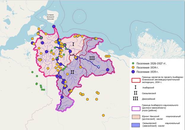
Fig. 1. Dynamics of settlement of the population of Anabar district (compiled by the author) The placement of settlements in 1939 basically repeats the data of 1934, but visually it is possible to trace a decrease in the number of settlements, which can be explained by the enlargement of settlements as a result of the creation of the first collective farms – partnerships and collective farms. A comparison of the boundaries of the land surveys conducted by the land survey expedition with the modern administrative boundaries of the grassroots territorial units showed that the recommendations included in the draft report were taken into account. The exception is the annexation of the Jesse Nasleg to the Saskylakh in 1954 . ConclusionThe Anabar-Olenek land survey expedition recorded 36 belekhs on the territory of the Anabar district. The largest number of belekhs were united by 2-3 farms. Belekhi as a form of settlement of the population of Anabar district were permanent and persistent associations of individual farms, due to a number of production and organizational motives, consisting mainly of small farms. Grouping farms in belekhi is a forced step of survival and joint management, dictated by natural and economic conditions and regulated by the local population. Thus, the available detailed information about the population, considered by the example of the report of the Anabar-Olenek land management expedition, can be used as one of the important sources for studying the number and settlement of nomadic ethnic groups before transferring to a sedentary lifestyle. ThanksArticle with the support of the RFBR grant, project 20-09-00257 "Khatango – Anabar region in the XX – early XXI centuries: anthropology of cultural landscape"
References
1. Borisov E.A., Mironov E.I. The history of the formation of land management in the Republic of Sakha (Yakutia) // Eurasian Scientific Association. 2019. No.12-6(58). pp. 507-509.
2. Volzhanina E.A. Yamal territorial registration expedition of 1934-1936 in the Yamal peninsula: working conditions and emotional state of participants // Scientific Bulletin of the Yamalo-Nenets autonomous okrug. 2018. № 2 (99). pp. 22-30.
3. Volzhanina E.A. Emotional experiences as a result of adaptation of participants’ of the Yamal Northern territorial registration expedition to the extreme work conditions // Kunstkamera. 2018. № 2. pp. 20-30.
4. Volzhanina E.A. The experience of the relationship of the northern land survey expeditions with the indigenous population in the first third of the XX century. // Mission of anthropology and ethnology: scientific traditions and modern challenges. Collection of materials. Izhevsk 2017. p. 129.
5. Volzhanina E.A. Participation of the indigenous peoples of the North in the work of the Yamal North-planning expedition in 1934-1936. // Questions of the history of Siberia. collection of scientific articles. Omsk. 2017. pp. 14-20.
6. The History of Yakutia: in 3 vols. Vol. III / Ed. by A.N. Alekseev; ed. by S.I. Boyakov. Novosibirsk: Nauka, 2021. 592 p.
7. Sakha Republic (Yakutia) archive. F. R.55, Op.30, D. 454. The project of land management of the Anabar district for 1934. Volume I.
8. Sakha Republic (Yakutia) archive. F. R.55, Op.30, D. 455. The project of land management of the Anabar district for 1934. Volume II.
9. Sinitsyn F. L. Land management of "nomadic" territories of the USSR (1920s — 1930s) // Land management, cadastre and monitoring of lands. 2018. No.8. pp. 37-41.
10. Stars I.N. Identity policy and land management of small peoples of the Russian North: ethnicity, class, departmental (the turn of the 1920s-1930s) // Bulletin of the Surgut State Pedagogical University. 2018. No.6. pp. 60-76.
11. Stepanova O.B. Hunting of the Northern Selkups in the 1920s-early 1960s: a review of the manuscript by E.D. Prokofieva // Archivist's Bulletin. 2021. No. 3. pp. 827-839.
12. Turov S.V. Experience of reconstruction of ancestral (communal) lands of the indigenous population of Obdorsky Krai on the data of field research of the second half of the 1920s-the first half of the 1930s. // Bulletin of Vyatka State Pedagogical University. 2014. No. 10. pp. 61-71.
Peer Review
Peer reviewers' evaluations remain confidential and are not disclosed to the public. Only external reviews, authorized for publication by the article's author(s), are made public. Typically, these final reviews are conducted after the manuscript's revision. Adhering to our double-blind review policy, the reviewer's identity is kept confidential.
The list of publisher reviewers can be found here.
M.V. Lomonosov's words are known that "Russian power will grow over Siberia and the Arctic Ocean." The sagacity of the words of the "first Russian university" clearly shows the successes of the West Siberian fuel and energy complex, the achievements of Yakutia and much more. But in the XVIII century, during the time of Lomonosov, the vast expanses beyond the Ural Ridge were just beginning to be explored by Russian explorers. However, even in the XX century. in many ways, the development of the vast expanses of the Russian East, especially such remote and hard-to-reach territories as Yakutia, Kamchatka, etc., had just begun. It should be noted in particular that starting from the second half of the XVI century, the mono-national Moscow state begins a gradual transformation into a multinational Russian state, in which peoples living in vast expanses differ in language, culture, economic structure and temperament. In this regard, it is of interest to study various aspects of the territorial and spatial settlement of the Far East. These circumstances determine the relevance of the article submitted for review, the subject of which is the Anabar (Dolgan-Evenki) national District of the Republic of Yakutia. The author sets out to analyze the demographic situation in the area, consider the spatial settlement in the specified area, as well as compare the boundaries of the land surveys conducted by the land management expedition with the modern administrative boundaries of the grassroots territorial units. The work is based on the principles of analysis and synthesis, reliability, objectivity, the methodological basis of the research is a systematic approach, which is based on the consideration of the object as an integral complex of interrelated elements. Comparative, cartographic and other methods are also used in the work. The scientific novelty of the research lies in the very formulation of the topic: the author seeks, using the example of the report of the Anabar-Olenek expedition of 1934, to characterize the possibilities of using the materials of land management expeditions as a historical source for studying the population of local territories. The scientific novelty of the article also lies in the involvement of archival materials. Considering the bibliographic list of the article, as a positive point, we note its versatility: in total, the list of references includes 12 different sources and studies. Of the sources attracted by the author, we note first of all the materials of the National Archive of the Republic of Sakha (Yakutia). Among the studies used, we will indicate the works of E.A. Volzhanina, F.L. Sinitsyn, N.I. Stasia, which focus on various aspects of land management of the small peoples of the Russian North. Note that the bibliography of the article is important, both from a scientific and educational point of view: after reading the text of the article, readers can turn to other materials on its topic. In general, in our opinion, the integrated use of various sources and research contributed to the solution of the tasks facing the author. The style of writing the article can be attributed to scientific, at the same time understandable not only to specialists, but also to a wide readership, to anyone interested in both the history of the Russian North in general and Yakutia in particular. The appeal to the opponents is presented at the level of the collected information received by the author during the work on the topic of the article. The structure of the work is characterized by a certain logic and consistency, it can be distinguished by an introduction, the main part, and conclusion. At the beginning, the author determines the relevance of the topic, shows that "the Anabar district is the only administrative–territorial entity in Yakutia where representatives of small-numbered peoples, the Dolgans, live." Analyzing the section "Population" from the report of the Anabar-Olenek land management expedition, the author draws attention to the fact that "the value of information about the population is that they were obtained directly from local residents and were planned to be used to create collective farms and settle nomads." The work shows that "belekhi as a form of economic settlement were characteristic of the entire territory of Yakutia," which was due to "the small number of farms, the insufficiency of able-bodied family members in it to perform the entire complex of production processes that were required for conducting a nomadic complex economy." The main conclusion of the article is that "belekhi as a form of settlement of the population of the Anabar district were permanent and persistent associations of individual farms, due to a number of production and organizational motives, consisting mainly of small farms." The article submitted for review is devoted to an urgent topic, is provided with 2 tables and 1 figure, will arouse readers' interest, and its materials can be used both in training courses and as a source for studying the number and settlement of nomadic ethnic groups before transferring to a sedentary lifestyle. There are comments on the article: for example, there are some typos in the text. However, in general, in our opinion, the article can be recommended for publication in the journal Genesis: Historical Research.
Link to this article
You can simply select and copy link from below text field.
|
|