|
MAIN PAGE
> Back to contents
Historical informatics
Reference:
Shpirko S.
Application of variation modeling to reconstruct the size of the medieval rural population (using the example of the Pskov land in the middle of the 16th century)
// Historical informatics.
2023. № 4.
P. 114-133.
DOI: 10.7256/2585-7797.2023.4.69216 EDN: BKYKVO URL: https://en.nbpublish.com/library_read_article.php?id=69216
Application of variation modeling to reconstruct the size of the medieval rural population (using the example of the Pskov land in the middle of the 16th century)
Shpirko Sergey
Associate Professor, Moscow State Historical Archives Institute, Russian State University for the Humanities
119313, Russia, g. Moscow, ul. Leninskii Prospekt, 88 korpus 3, kv. 122

|
shpirkos@mail.ru
|
|
 |
Other publications by this author
|
|
|
DOI: 10.7256/2585-7797.2023.4.69216
EDN: BKYKVO
Received:
04-12-2023
Published:
31-12-2023
Abstract:
As part of an interdisciplinary approach, historians are increasingly using the ideas and methods of the mathematical sciences in their research. This, for example, arises in reconstruction problems from the field of historical geography, when the initial data is insufficient for traditional analysis. The subject of this study is to model the system of spatial distribution of the medieval population and demonstrate its results using a specific example. To take into account the condition of territory heterogeneity during modeling, the author develops a variational approach proposed by S.M. Huseyn-Zade. Using the methods of the calculus of variations and Pareto optimality within the framework of this approach makes it possible to identify and numerically describe the relationships between the optimal parameters of the system. To solve this problem of reconstruction, a model of a two-level hierarchy of placement of centers was previously proposed. Its approbation on the material of the scribal description of the Shelonskaya Pyatina of the Novgorod land at the end of the 15th century showed a high degree of correlation between real and theoretical data. The first surviving scribal description of the Pskov lands dates back to the second half of the 80s XVI century. It records a huge mass of abandoned lands as a result of the Livonian War. To assess the scale of this crisis, we first need data on the size of the rural population in the previous period of time. Unfortunately, the scribal description of the mid-16th century, which is closest to it in time, has not survived. However, the above-mentioned first surviving scribal description contains retrospective information about an earlier time, which makes it possible to apply the modeling results to solve the desired reconstruction problem, which is novel.
Keywords:
mathematical modeling, scribe 's book, center placement system, population density function, pogosts, hierarchy of centers, Pareto equilibrium, calculus of variations, functional, linear regression
This article is automatically translated.
You can find original text of the article here.
Introduction Recently, researchers have increasingly used the ideas and methods of exact mathematical sciences to solve problems in the historical field of knowledge. A similar situation arises, for example, in the field of historical geography when solving the problem of population reconstruction in case of incompleteness or, in general, lack of initial data for direct calculation. As such a model example, the author considers the task of reconstructing the rural population of Pskov land in the middle of the XVI century, that is, before the outbreak of the Livonian War and subsequent economic ruin. Perhaps the only type of written sources that allows reconstructing the settlement structure (the system of population accommodation) of that time are scribal descriptions. Their creation is directly related to education at the end of the XV century. The Russian centralized state is conditioned by the need to assert the grand ducal authority in the newly annexed territories, including in matters of streamlining tax collection. The Russian chronicles inform us that the first scribal description of Pskov and its lands was made in 18. (1510) immediately after its accession to the Moscow state [1, p. 87; 2, p. 10; p. 46]. Written sources also report on subsequent scribal descriptions of the Pskov land, produced during the XVI century. The description of 1557-1559, which unfortunately has not been preserved, is the closest to the studied time period. According to the chronicle, it was started in 65 and entrusted to several scribes: under the 65th year, a letter from Grigory Nagy with comrades is mentioned, under the 66th - a letter from Prince Vasily the Great with comrades, and under the 67th – Zachary Pleshcheyev and Alexei Stary with comrades. The first one that has come down to us is a scribal description (though incomplete), produced by Ivan Drovnin and Grigory Meshchaninov–Morozov in 1585-1587, and currently stored in the fund of the Local Order of the RGADA. First of all, let's consider the opportunities provided to the researcher within the framework of the traditional approach. For calculations in the absence of total population totals, historical geography, according to Y.E. Vodarsky, has two methods: by average density and by the amount of natural population growth [4, p. 76]. We will demonstrate the work of these retrospective methods by using the example of A.I. Kopanev's calculation of the population of the entire Russian state in 1550. A.I. Kopanev starts from the figure obtained by A.M. Gnevushev for three Novgorod pyatinas based on the first scribal descriptions of the turn of the XV–XVI centuries. Equating the other two Novgorod pyatinas and Pskov land with them in terms of population, the researcher comes to a figure of 1 million people for the entire Novgorod-Pskov land in 1500. Further, taking the percentage of population growth of 50% proposed by P.P. Smirnov over half a century, Kopanev calculates the population of the Novgorod-Pskov land in 1550 at 1.5 million people. Next, Kopanev proceeds to discuss the ratio of the areas of Novgorod-Pskov land and the whole country as a whole. The area of the latter, according to I.A. Golubtsov's historical map, he estimates the area of the sparsely populated northern and northeastern regions at 2,000 thousand square kilometers. The area of the Novgorod-Pskov region is 316 thousand square kilometers. Thus, its territory is 6 times smaller than the territory of the whole country. According to Kopanev, the placement of the population in the country is similar to its placement in the Novgorod-Pskov region: more in the southern part and less in the northern. Therefore, having increased the population of the Novgorod-Pskov land by 6 times, it comes to the total number of the whole country in 1550 at 9 or 10 million people. 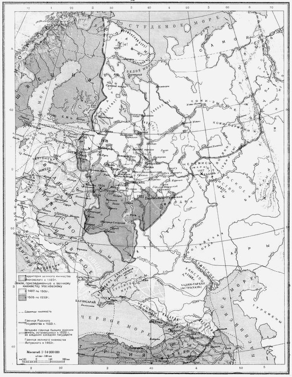
Fig. 1 Bazilevich K.V., Golubtsov I.A., Zinoviev M.A. Formation of the Russian national state (1462-1533)// Atlas of the history of the USSR, part I. 1948 ([Electronic resource]: https://geoportal.rgo.ru/record/9567 ) (accessed 12.11.2023) Unlike Kopanev, Vodarsky himself adheres to a slightly different approach in his calculations. He starts from the results of the first general census of 1646, which he estimates at 7 million people. Vodarsky considers the 50% population increase adopted by Kopanev for the first half of the XVI century to be overestimated and is guided by estimates obtained by demographer B.Ts Urlanis. Here are his estimates of natural growth, taking into account additions and losses: 1500-1550 – 15%, 1550-1600 – 5%, 1600-1650 – 0%. Recalculating the population in the opposite time direction, taking into account these estimates, Vodarsky concludes that 6.5 million people lived in Russia in 1550. [4, p. 77]. The researcher also criticizes the calculation of the population used by Kopanev based on the ratio of areas. The area of the southern part of the Novgorod-Pskov region is 139 thousand square kilometers, and the northern part is 177 thousand square kilometers. Their ratio is 44:56. At the same time, the ratio of the southern (1110 thousand square kilometers) and northern parts (890 thousand square kilometers) is the opposite to what it was for the Novgorod-Pskov region. Therefore, it was necessary to increase the population not for the entire region (by 6 times), but for the southern and northern parts separately by the same number of times, how many times the area of the same parts of the country. We conclude this review with a statement of our own point of view regarding the use of traditional methods. Firstly, both Vodarsky and Kopanev proceed from the a priori assumption that both values under consideration (the area of the territory and the number of people living on it) are related by a proportional law: how many times the area is larger, the population will be the same number of times. Although, in fact, this assumption needs to be substantiated. Secondly, both researchers operate with an average population density, although it is clear that the density can vary significantly in the studied area. As an illustration of this reasoning, Figure 2 shows a cartographic diagram of one of the districts of the Village Pyatina with historical settlements localized on its territory by N.V. Piotukh and A.A. Frolov. As you can see, there are areas with a large concentration of settlements in this territory, there are more sparse, and there are completely deserted areas: 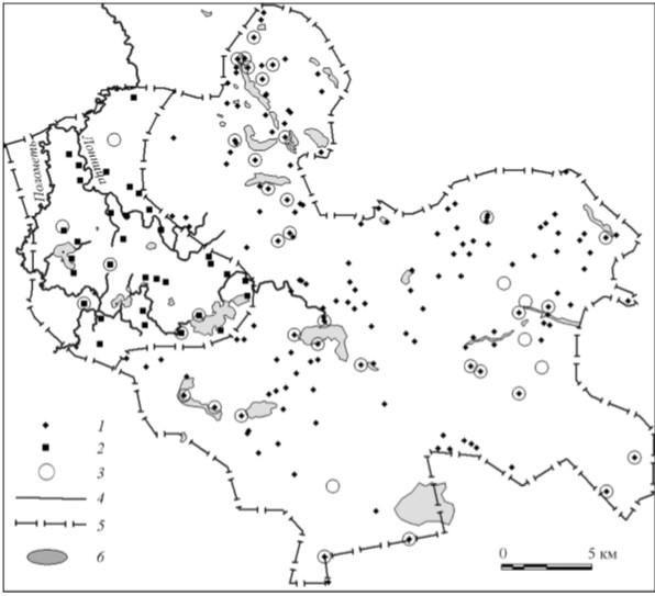
Fig. 2. Cartography of the Gorodenskoye churchyard: 1-settlements of the elevated part, 2-settlements of the lowered part, 3-settlements according to the General surveying scheme within the boundaries of the former Gorodenskoye churchyard, 4-rivers, 5-borders of parts of the churchyard, 5-lakes (source: [5, p. 48]). Recent advances in mathematical science make it possible to take into account such heterogeneity of the territory when modeling. Namely, this paper will focus on the application of the variational approach proposed in the 1980s. Soviet mathematician S.M. Huseyn-Zadeh for modeling the system of center placement and developed in a number of recent works by S.V. Shpirko[6, 7]. Looking ahead a little, we note that the obtained modeling results confirm, among other things, the hypothesis of a relationship between the above-mentioned values of the area of the territory and the number of people living on it, but it It is not linear, but power-law. Chapter I. Two-level model of the hierarchy of centers Let's imagine the density of settlements using the function p(x), which takes different values at points x of the studied territory D. Among them, a part of the settlements stands out, which, in addition to the economic function, perform a number of additional ones for the surrounding population: administrative, commercial, defensive, religious, etc. We will call such settlements, as is customary since the classic works of Kristaller–Lesh, central (centers, central places) [8, pp.140-149]. The central settlements are also scattered unevenly throughout the territory, and a hierarchy is possible between them: some perform some functions, some others. In this article, we will consider a two-level system of center placement: 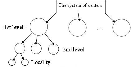
Fig.3. A 2-level system for the placement of centers on the territory Similarly with the function p(x), we will consider the densities of the placement of these centers as functions of space: for the 1st (highest) level center, it is q 1(x), and for the 2nd (lowest) level, it is q 2(x). The specific type of these functions is specific to each settlement system and is determined by the logic of its development. According to our assumption, this logic is universal and consists in the fact that each of the participants in the settlement process is guided in their actions by natural goals and tries to realize them to the fullest extent (optimally). For a 2-level settlement system, we count three such goals. Firstly, each of the participants in this process (household owners) tries to place their settlements (yards) near the cultivated areas (zones of influence). As an indicator of the success of this goal, let's take the radius of the zone of influence near the x point. It cannot be too small, otherwise the household will not have enough resources. It cannot be too large either – the available resources will not be enough to process such a large area. As a compromise, this indicator should have some fixed "reasonable" value. Secondly, each locality is located as close as possible to its center of the 2nd level. The indicator here is the distance from the settlement near point x to its center of the 2nd level. Naturally, it should be as small as possible. Thirdly, the centers of the 2nd level, in turn, are located as close as possible to their center of the 1st level. By analogy with the previous one, the indicator here is the distance from the center of the 2nd level near the point x to its center of the 1st level. Naturally, it should also be as small as possible. The individual indicators of each of the participants, when put together, turn into 3 integral indicators of the entire system. Mathematically, they are expressed as functionals F 1, F 2, F 3, depending on the functions p(x), q 1(x), q 2(x) as their variables. That is, substituting other functions into these functionals each time, we get, generally speaking, different numerical values. Then, to achieve the first goal, you need to select the functions p(x), q 1(x), q 2(x) so that F 1 equals a fixed value. To achieve the second and third goals, the resulting values of F 2 and F 3 should be minimal. It is clear that it is impossible to achieve this result for the same functions p(x), q 1(x), q 2(x), since all three goals separately implement opposite trends. Thus, the implementation of only the first goal will lead to an even settlement of the population across the territory (Fig. 4, b)). The implementation of the second or third goal will lead to the concentration of settlements at one point. Taking into account all three goals should lead to a compromise, which is reflected in Fig.4 (a) in the form of a nesting type of spatial settlement: as we approach the center, settlements will thicken, and, conversely, as we move away from it, settlements will be located more sparsely, trying to "cover" as much territory as possible. 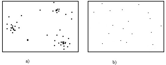
Fig.4. Types of spatial settlement placement: a)–nesting, b)–random Mathematically, this problem can be written as a Pareto equilibrium search, which ultimately boils down to finding such functions p(x), q 1(x), q 2(x), at which the minimum value of the functional is achieved – a linear combination of the original F 1, F 2, F 3: ? F 1+? F 2+? F 3 -> min, where ?, ?, ? are numerical constants, and ? and ? are non–negative. Solving this variational problem, we come to the relations connecting the obtained optimal functions p(x), q 1(x), q 2(x) [7]. Note that all of them are of a sedate nature. Thus, the function p(x) of population density is proportional to the density function of the centers of the first level, raised to the power of 1/7: p(x)=D q 1(x)1/7, where D is some positive constant. This can be interpreted as follows: the denser the population lives in the territory, the thicker the network of central settlements there. Denote by ? 1(x) the area of the zone of influence of the center of the 1st level near the point x. Taking into account the known ratio between the area of the territory and the density of the centers on it ? 1(x)=1/ q 1(x), the previous equation will be written as follows: p(x)=D ?1(x)-1/7. The exponent here is already negative, which reverses the previous ratio. That is, the denser the population lives in the territory, the smaller it is in area. Let's introduce another notation. Using n 1(x), we denote the population in the zone of influence of the center of the 1st level near the point x. Taking into account the formula n 1(x)=p(x)? 1(x) (the population is equal to the product of the population density by the area of the occupied territory) from the last equation we arrive at the following ratio: n1(x)=D?1(x)6/7 (1) It follows from the last relation that the dependence between the quantities n 1(x) and ? 1(x) is the same as that between p(x) and q 1(x), but with a different exponent. Thus, the larger the area of the territory, the larger the population living on it. Translating this ratio to a logarithmic scale for convenience, we get ln n1(x) = A +6/7 ln ?1(x). Thus, the graph of the dependence of ln n 1(x) and ln ? 1(x) in the described model is a straight line with an angle of inclination of 6/7. The approbation of the proposed model was carried out by the author when analyzing the settlement structure of the Shelonskaya Pyatina of the Novgorod land at the turn of the XV–XVI centuries. based on the materials of the first universal scribe description. The initial data were the preserved data on the number of obezh (taxed land–an analogue of the area in formulas) and yards (an analogue of the population) for 24 churchyards-districts of Shelonskaya Pyatina, collected by A.M. Andriyashev [9]. The verification of the correspondence of this theoretical result to empirical data was carried out using the Statistica statistical software package. Below is a graph of the dependence of the logarithm of the number of runs on the logarithm of the number of yards: 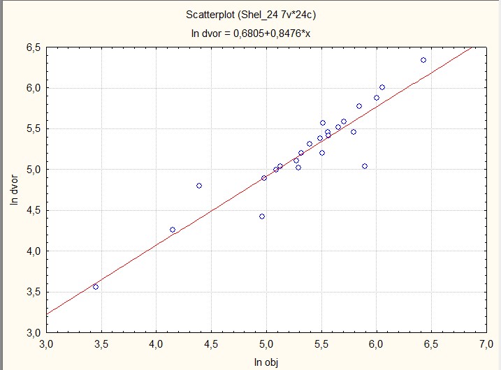
Fig.5 Scattering diagram for the logarithm of the number of yards (ln dvor) and the logarithm of the area of the churchyard-district (ln obj) (source: [7]) So, the hypothesis of a linear relationship between the above-mentioned features (ln dvor and ln obj) is confirmed with a significance level above 0.95. The coefficient of linear regression between them is 0.8476, differing from the theoretical one (6/7) by less than 0.01. The correlation coefficient between the features is 0.93. That is, changes in the dependent trait are explained by changes in the independent one by about 87% (coefficient of determination). The high degree of correspondence of the obtained theoretical and empirical data for the Shelonskaya and Derevskaya Pyatinas of the Novgorod land [6, 7] allows us to transfer the results of this mathematical modeling to the study of the historical rural settlement of the neighboring Pskov land. Chapter 2. Viceroy's food according to the "old letter" based on the census of 1585-1587.
The scribal description of 1585-1587 has come down to us in two manuscripts. The oldest of them, the payment card (book No. 355 ), was published in the Collection of the Moscow Archive of the Ministry of Justice in 1913. This manuscript is an original with a paperclip by Ivan Drovnin, compiled in Pskov for the needs of the voivodeship administration. It consists of two separate volumes. The first volume describes the city of Pskov with its 7 ambushes and the city of Gdov. In the second –Gdovsky district and the rest of the Pskov suburbs with their counties. In both volumes, when describing land holdings, if the owner had several villages and wastelands, the scribe indicated the name of only the first and then gave their total number. Further, he indicated how much money there was in the living and in vain, ignoring the number of yards in the villages and not explaining exactly how many chet you need to pay. They also did not provide information about the amount of hay and forest, nor about the good, medium and thin land. The second manuscript, actually a scribe's book, has come down to us in the list of the XVIII century. (books Nos. 827, 830), and serves to explain and complete the previous one. Book No. 830 describes all 7 Pskov ambushes: Demanitskaya, Meletovskaya, Belskaya, Zaklanskaya, Prudskaya, Zavelitskaya and Rozhnitskaya. In this book, all villages and wastelands belonging to secular and spiritual landowners are named by name; the number of peasant and Bobyl households is shown, which is not in book No. 355. Book No. 830 has the same structure, containing a description of Gdovsky, Kobylsky, Izborsky, Ostrovsky, Voronachsky, Vyborsky and Dubkovsky counties (7 counties). To determine the population in the 50s of the XVI century, data from book No. 827 on the income of the Izborsky and Gdovsky governors appointed by the sovereign charter of 1510 are critically important. "from married people, from person to person." They were first published by S.V. Rozhdestvensky in the "Notes of the Imperial Russian Archaeological Society" in 1897, and in this article are given in Appendix 1 and Appendix 2. Let's give a brief description of the viceroy's income listed in them, following the conclusions of S.B. Veselovsky [10, pp. 267-270]. Governorships, along with volostships, were, until the turn of the XV–XVI centuries, the dominant form of remuneration for service and maintenance of military and commanding princely servants. The governors and volostels were at the same time judges, rulers and revenue collectors of the princes, and the governors were also military commanders of the local defense. In addition to court fees, they were the recipients of many less significant income related to their management activities. In the cities, the governors had the right to keep an inn and sell intoxicating drinks. In order to combat horse theft, the branding of horses and the registration of their sale and barter were practiced. At the same time, a fee was charged from each transaction from the seller and the buyer, called "horse spot", and horses sold and exchanged were recorded in "wool and signs" (special books). The duties of the governors and volostels to observe the newcomers resulted in a fee called a turnout fee or turnout. A remnant of ancient times was the fee charged for marriage: the newly married ubrus–within the parish, and the brood marten–from women who married outside the parish. The main income of the feeders was actually feed. When the forager "drove" into the parish, the population traditionally presented him with a treat, which was called "incoming food". It was voluntary, so many charters and income lists do not mention it. Three feeds were mandatory: Rozhdestvensky (on December 25), Velikodensky (on Easter) and Petrovsky (on June 29, art. The composition of the Christmas food included meat and bread, for the horses of the feeder – oats and hay. On the Great Day – only meat and bread, and on Peter's Day–a ram and bread. If the breadwinner was "unloved" with food in kind, then he could demand it with money, and at the rates indicated in the charter to the population or according to the income list received on hand when sent for feeding. In the first passage (Appendix 1), the viceroy's income for Gdov and its county is calculated according to the letter of Grigory Nagy in 65, that is, 1557. At the beginning, the incoming feed is indicated, collected from Gdov in money in the amount of 2 Moscow rubles. Then there was the "bread" collected from the rural people of the county in kind and included rye, oats and hay. Another monetary fee is given without a name. It is collected from rural people once a year, at Christmas, from married people for 1 Moscow money (a total of 10 rubles and 9 altyn without 2 money – from 2052 people). As part of these rural people, the lords (belonging to the Archbishop of Novgorod), monastic, church, landowner peasants and all "without a name, no matter who" are listed. Further in the text, all these three collections are combined again under the name "incoming feed". The list of viceroy's income ends with a tavern, a spot, a pomer, a newly married marten and a turnout. In the second passage (Appendix 2), the viceroy's income for Izborsk and the county is calculated. Moreover, unlike the first one, information is provided regarding the census of 1585-1587, which is modern to the scribe. When transferring income, the scribe adheres, in general, to a similar scheme as in Gdov with the county. First, the income and entry fee in the amount of 2 Moscow rubles from the Izborsk posad and the county are indicated. Next, the feed from the Izborsk posad and the district of married people is indicated once a year on Christmas day for Moscow money (total 1 ruble and 9 altyn from 250 people). At the same time, it is explained that this composition (landlords, monastic and church people) did not include black (sovereign) villages according to the royal order of scribes Grigory Morozov and Ivan Drovnin, that is, this was exactly what happened during the census of 1585-1587. The list of viceroy's income ends with a horse patch, a brood marten from the bride and groom, and a tavern. Of exceptional interest is the insertion in this text concerning an earlier time. Namely, immediately after calculating the viceroyage from the married people of the district, it is reported that the "old" letter also included black villages, which amounted to 6 rubles from the Izborsky district (from all its 6 lips) from all 1,360 married peasants for 1 Moscow money. It is further clarified that before the letter of Zachary Pleshcheyev (recall, this is 1559), the viceroy's feed also included "bread" from 2 black lips (Nikolskaya and Pavlovskaya), including rye, oats, wheat, malt, flax and "business" money. But under Zakhariy Pleshcheyev, he was put in the "posopnaya" and left to the lips, and the governor was paid in cash in the amount of 21 rubles, 27 altyn and 4 Moscow money.
The above excerpts show a picture of the gradual destruction of the viceroyage feeding system in the 80s of the XVI century. Part of the income is withdrawn from the feeders, and those that remain are split into parts; natural ones are everywhere transferred to money. The analysis of information related to the "old" letter allows attributing them to the time of the previous census of 1557-1559. They provide extremely valuable information about the number of rural married population of that time in two counties of Pskov land. The same data on the population according to the census of 1585-1587 allow us to estimate the scale of the changes that took place during this period of time. Thus, the married male population of Izborsk county decreased from 1,360 to 250 people, and the last figure includes its entire settlement. Chapter 3. Settlement structure of Pskov land in the middle of the XVI century. The Pskov land of that time (its total area was about 21900 sq. km. [11, p. 27]) was divided into 14 counties, consisting of 149 provinces, 2 quarters, 2 villages and 1 volost. The lips of the largest district–Pskov (7520 square kilometers) – were additionally distributed into 7 ambushes. The territorial unit of Pskov land was the bay, which had an average area of about 150 square kilometers. 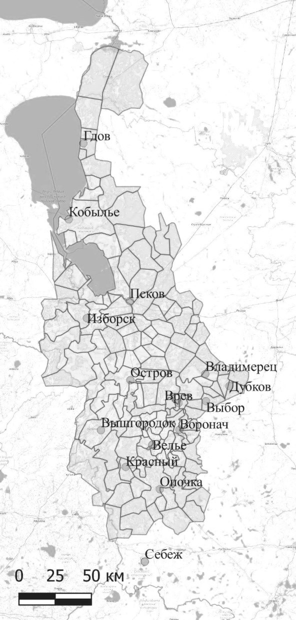
Fig. 6 Cities and lips of Pskov land in the 1580s. (the map was built by the author on the basis of materials [12, p. 268]) The historical predecessor of the lips were the volosts appearing in written sources of the Pskov independence era. This term is not found in scribal books, but continues to be used along with lips in local office work. This is evidenced, for example, by the documents of the Pskov Pyatnitsky Monastery from the Fords, introduced into scientific circulation by S.N. Kisterev and V.A. Arakcheev. Appendix 3 contains a loan letter of August 1564, according to which two Pyatnitsky peasants from Kolbezhitskaya volost occupy 2 bunches of rye from the monastery. Appendix 4 contains an unsubscription dated March 1, 1574, issued to the same monastery by the royal tribute collector in receipt of an annual tribute from the Pyatnitsky peasants of the Kolbezhitsky lip of the Zavelitsky ambush. Thus, we can assume that in the materials of local records management, the use of the names guba and volost for Pskov land in the XVI century, in general, was equivalent. Undoubtedly, the concept of a parish is broader. According to the definition of M.F. Dovnar-Zapolsky [13, p.55], it meant an organization of urban and rural residents united by volost land and self-government. The volost land was a burden, which was expressed in the serving of taxes and duties by all its members. So, in the same signature of the tributary (Appendix 4), among the annual taxes and duties are listed: yamsky and conspicuous money for city and zasechny affairs, food money, salary for the elders of the big, this money for the podyachy and for the viceroy's income. Volost organization can be considered a form of organization and self-organization of the local population. The permanent guardian of the community (volost) interests was its chosen head, the headman. He was the executor of her decisions. Let's give a brief description of its most important functions, following the conclusions of M.D. Dovnar-Zapolsky on the material of Lithuanian Rus, where the institute of "elders" played a similar role at that time. The main function of the elder was to collect taxes, as well as their layout, which he performed in the presence of the "husbands" of the parish. It is worth noting that when distributing taxes, the community had to conform to the property status of each payer so that "the "lesser" had less, and the "greater" had more" [13, p. 83]. During the census of the population for fiscal purposes, the elder was also present at the deacon of the Gospodarsky (Grand ducal and royal). He also represented the interests of the municipality in those cases when it had to make requests for a reduction in taxes or a new distribution. The governor was a rare guest in the parish, so all matters (inquiries) were decided by the elder. So, Dovnar-Zapolsky quotes from the sheet of Queen Bona from 1544 to the sovereign (governor) Usvyatskaya volost (located in the south of the present Pskov region): "they are the elders of the boundary chosen by themselves, they may be there and the waters of a long-standing familiar custom may be there to help and rejoice" [13, p. 57]. The elder was also responsible for the well-known area of the court, in particular, on board and boundary cases. The center of the parish, both in Lithuanian Rus and Pskov land since independence, was the city. For the lips of the time when the Pskov scribal books were compiled, this was a settlement with a church and houses of the clergy, which, as in the Novgorod land, was called a churchyard. The exception is the southern region of Pskov land, in which there are quite a lot of lips belonging to the cities of Vreva, Voronach, Velya, Choice and Opochka. The names of such lips are derived from the names of parish churches. All of them are located in the immediate vicinity of their city. For example, as Kharlashov points out, the five provinces of the Voronachsky district, which had parish churches in the suburb itself, cover the territory, the center of which, before the construction of the Voronach fortress, was the settlement of Savkino. The lips of the southern part of Voronach County were formed on the basis of settlement nests that developed parallel to the Savkino-Voronach district [11, p. 31]. Thus, it is possible to state the later addition of the settlement structure of the southern region of Pskov land, many territorial units of which were formed as a result of the collapse of larger structures–volosts. Chapter 4. Numerical simulation results
Taking into account the above, let's consider a 2-level model of the hierarchy of centers (settlement structure) for the Pskov land in the middle of the XVI century: churchyard (lip)–village or village (landowner, monastery or church property)–village: 
Fig.7 2-level settlement structure of Pskov land in the middle of the XVI century. To solve the problem of reconstruction, it is enough to calculate the number of rural population for each of the Pskov provinces using the formula (1) (Chapter 1). As the value ? 1, we will consider the total area of the lip, calculated in square kilometers (Appendix 5); as n 1, only the aggregate of married men. Substituting a known number of them (1,360 people) according to the Izborsky district in formula (1), we find the proportionality coefficient D, specific to the entire Pskov land of that time (mid-XVI century.). With this in mind, calculating all values of n 1 using this formula, we come to a model estimate of the total number of married peasant men throughout Pskov land – about 23 thousand people. Further, as N.N. Maslennikova points out, peasant households in Pskov villages were few in number (there were an average of 1.08 "people" per yard) [14, p. 93]. Then you can use the conversion factor (5.25 people per yard), given by A.L. Shapiro [1, p. 20], and get the total number of persons of both sexes – about 110 thousand people. Naturally, only peasants are included in this calculation, excluding residents of Pskov and the suburbs and the unfree population of private owners (serfs). Comparing this number with a similar estimate for the Shelonskaya and Derevskaya pyatinas [6, 7], we conclude that the human resources of the Pskov land and the most developed Novgorod pyatinas of that time roughly coincided. Appendix 1 About the viceroy's income to the governor of Gdovo And the income of the namesake according to the Gdov charter of the tsar and the great Prince of summer and according to Grigoriev 's letter Nagovo from the goods of the summer of this year from Gdov from the whole city leaving with his namesake Odinov in the year of two hundred Pskov rubles in total two Moscow rubles and two cornfields of rye two cornfields of oats two carts of hay yes from the Gdovsk district with rural people from the lords and monastic and ecclesiastical and from the landowners with all without exchanging anyone with the peasants for a year on the Birth of Christ with two thousand from fifty z two people married ledei from a person for money according to Moscow total, deset rublev and devyat altyn without two money, then he and with tivun and z dovotchiki and all the same to the Gdov namesake, food from the Gdov congress and from the Gdov district for a year entering twelve rubles and a devet altyn without two Muscovites, four quarters of rye, four oats, two carts of hay, and the governor keeps a tiuna in the city on Gdov , and three dovotchiki, and the governor a tavern of honey and beer, five and a dead marten newlywed yes, from visitors from shopping malls, from the appearance of a man, Moscow money Source: RGADA, F. 1209 Op. 1 Book 827 L. 338 Appendix 2 On the viceroy's income to the Izborsk viceroy
And to the income of the Izborsk namesake from the city from the posad and from the whole Izborsk district from the shty gubernia from the tsar and the great prince from the black villages and from the landowners and manostyrsk and from the church peasants, yes, the taxes to the governor of the ruble of Moscow and all the taxes two rubles for the tsar and the great prince of Korma from year to year for the Birth of Christ from the city from the posad and from the Vyborsky district from the landowners and from the monostyrsky and church z married people from two hundred from five dozen from four people for Moscow money per person , a total of a ruble and nine altyns to cover the black villages and according to the old letter it went to the namesake of the korm from the Vyborsky district from all the shty lips from the black and from the landowners and from the monasteries and from church peasants married from a thousand from three hundred to fifty people in Moscow money, a total of six rubles a (nne) in black in black (drvni) peasants /..illegible.. / houses because, according to the sovereign's order, Grigory Morozov and Ivan Drovnin were not ordered to write from the goods of the black villages, but behind the namesake there is a horse stain and emlet from the Friday from the merchant and from the seller on the money in Moscow, and the brood marten from the groom and from the bride two altins, and behind the namesake there is a tavern of honey and beer and before Zakhariev's letter to Pleshcheyev went to the governor from Chernykh to two lips from Nikolsky and Pavlovsky to two hundred and twenty-four quarters of rye and four hundred and forty-four quarters of oats and fifty-six quarters of wheat, fifty-six quarters of malt, three hundred and three hundred and six handfuls of flax and business with three Moscow dollars each for bread, for a quarter of rye, six money Moscow yes, a quarter of oats three dengs Moscow for an osmina of wheat six denegs Moscow for an osmina of malt three dengs Moscow for three handfuls of flax three dengs Moscow total for bread and for lunch and for business money two hundred one rubles and two hundred seven altyn four Moscow and that bread is laid aside Nikolsky and Pavlovsky lips posobennoy (sic) bread Source: RGADA, F. 1209 Op. 1 Book 827 L. 744 vol. Author's note: Parentheses mean the conclusion in the title Appendix 3 August 1564 – The loan of the peasants of the Pyatnitsky monastery Boris Stepanov, son of Olfimov and Lukyan, from the abbess of the same monastery Apollinaria and the headman Klimenty for two cornfields of rye Se yaz, Boris Stepanov son of Olfimov, yes yaz, Lukyan O..mov son, pyatnitsky peasants from Kolbezhsk[oh] volost from Elyga, occupied if two of us from od... proverbs of Pyatnitsky mananastyr from Fords at igu[menya] Polinari and the headman of Olis at Klimentiy ... the horseman of the monastery bread has two rye bowls to [broy] for seeds from the Transfiguration of the Savior days before the Birth of Christ until the time without hasp. And he fields the bread according to the time, and they give us four-fifths for bread. And in x [loeb] and in naspa there are two loaners, who are in the face and love, on that bread and naspa. And for that reason: Pyatnitskaya clerk of the chapel Sophon Timofeev's son and Pavel Ivanov's son. And the clerk Wanda Vasiliev [son] of the summer of August 7072 wrote to the cabal of Pyatnitsky. On the back: After that, Sophon put his hand on it. Source: Department of Manuscripts of the Russian State Library (OR RSL). F. 178. Maps. 10974. No. 3 Appendix 4 March 1574, 1. –The signature of the tributary Ivan Sreznev to the clerk of the Pyatnitsky monastery, Ivan Okulov, in receiving Yamsky, conspicuous and food money for the viceroy's income, etc. In the summer of March 7082, day 1, the danseur Ivan Sreznev z Started the ambush from Kolbezhitskaya bay from the Pyatnitsky villages from the Fords of a man living in twenty with a calm with an octopus of Yamsky and noticeable money for policemen and for zasechnye affairs and food money and from the duty and for the elders of large salaries for the current seventy-second year, he took two money, yes, there is a lot of money on the available data, and for the viceroy's income last year in the seventy-first year he took two hundred and nine altyn. The clerk Ivan Okulov, the son of a peasant, paid the money of the Pyatnitsky monastyr. The unsubscribe was written by this podyachy Bezson Fedorov. Ivan Sreznev. Source: OR RGB. F. 178. Maps. 10974. No. 9.
Appendix 5 Reconstruction of the rural population of Pskov land by lips in the middle of the XVI century. | NN | the name of the lips | county | area in sq. km. | the number of married people | | 1 | Sinskaya | Island | 114 | 138 | | 2 | Ustenskaya | Vella | 75 | 96 | | 3 | Glinskaya |
Island | 75 | 96 | | 4 | Zabolotskaya | Island | 140 | 164 | | 5 | Rozhnitskaya | Pskov | 131 | 155 | | 6 | Luchinskaya | Dubkov | 65 | 85 |
| 7 | Naverezhskaya | Dubkov | 110 | 134 | | 8 | Spasskaya | Dubkov | 99 | 123 | | 9 | Pogostishchenskaya | Dubkov | 78 | 99 | | 10 | Glossy | Dubkov |
42 | 59 | | 11 | Diyatskaya | Choice | 47 | 64 | | 12 | Bogoroditskaya | Choice | 108 | 132 | | 13 | Kozmodemyanskaya | Choice | 65 | 86 | | 14 |
Krekshinskaya | Choice | 77 | 98 | | 15 | Bogoroditskaya | Vrev | 34 | 48 | | 16 | Nikolskaya | Vrev | 103 | 126 | | 17 | Poretskaya | Vrev | 10 |
17 | | 18 | Ilyinskaya | Vrev | 18 | 29 | | 19 | Pechanskaya | Vella | 69 | 89 | | 20 | Vorontsovskaya Quarter | Vrev, Pskov | 226 | 248 | | 21 | Kotelnskaya |
Choice | 177 | 201 | | 22 | Sigoritskaya | Volodimerets | 56 | 75 | | 23 | Nikolskaya | Volodimerets | 75 | 96 | | 24 | Golubinitskaya | Volodimerets | 180 | 204 |
| 25 | Slavkovskaya | Pskov | 108 | 132 | | 26 | Teblevitskaya | Pskov | 48 | 66 | | 27 | Demanitskaya | Pskov | 152 | 176 | | 28 | Verkhomoska | Pskov |
247 | 268 | | 29 | Nemoevskaya | Island | 161 | 185 | | 30 | Navolotskaya | Pskov | 132 | 156 | | 31 | Prutskaya | Pskov | 76 | 98 | | 32 |
The Medicine Woman | Pskov | 96 | 119 | | 33 | Pogostitskaya | Pskov | 77 | 98 | | 34 | Dubrovitskaya | Pskov | 48 | 65 | | 35 | Russian | Pskov | 48 |
65 | | 36 | Chirskaya | Pskov | 117 | 140 | | 37 | Stremutskaya | Pskov | 76 | 97 | | 38 | Kuneiskaya | Vella | 137 | 161 | | 39 | Borisoglebskaya |
Red, Velho | 130 | 154 | | 40 | Grivskaya | Vyshgorod | 120 | 144 | | 41 | Bogoroditskaya | Vella | 60 | 80 | | 42 | Zdvizhenskaya | Vella | 59 | 78 |
| 43 | Christmas | Vella | 82 | 104 | | 44 | The spell | Voronach | 123 | 147 | | 45 | Polyanskaya | Voronach | 73 | 95 | | 46 | Terebenskaya | Voronach |
94 | 117 | | 47 | Voskresenskaya | Opochka | 48 | 66 | | 48 | Kamenskaya | Opochka | 142 | 166 | | 49 | Ilyinskaya | Opochka | 188 | 212 | | 50 |
Sinovetskaya | Opochka | 143 | 167 | | 51 | Chernitskaya | Opochka | 242 | 263 | | 52 | Spasskaya | Opochka | 62 | 81 | | 53 | Kuzmodemyanskaya | Velya, Opochka | 383 |
389 | | 54 | Nikolskaya posadskaya | Opochka | 111 | 135 | | 55 | Egorievskaya Upper | Opochka | 269 | 287 | | 56 | Nikolskaya Dretskaya | Red | 115 | 139 | | 57 | Egorievskaya Nizhnyaya |
Opochka | 155 | 180 | | 58 | Petrovskaya Sineozerskaya | Red | 241 | 262 | | 59 | Pokrovskaya | Red | 194 | 217 | | 60 | Clavicle | Red | 145 | 169 |
| 61 | Spasskaya | Red | 106 | 130 | | 62 | Nikolskaya on Kudka | Opochka | 82 | 104 | | 63 | Bogoroditsky morning | Voronach, Opochka | 44 | 61 | | 64 | Grainskaya | Vella |
62 | 81 | | 65 | Ilyinskaya | Vella | 103 | 126 | | 66 | Plotychenskaya | Vella | 39 | 56 | | 67 | Nikolskaya | Red, Velho | 206 | 229 | | 68 |
Kokshinskaya | Vyshgorod | 269 | 288 | | 69 | Borisoglebskaya | Vyshgorod | 301 | 317 | | 70 | Korovinskaya | Vyshgorod | 661 | 622 | | 71 | Zaborovskaya | Island | 105 |
128 | | 72 | Yelinskaya | Vyshgorod | 78 | 100 | | 73 | Dubotskaya | Vyshgorod | 174 | 198 | | 74 | Kuhovskaya | Vyshgorod | 160 | 184 | | 75 | Ovsishchenskaya Staraya |
Vyshgorod | 199 | 222 | | 76 | Zalezhinskaya | Pskov | 102 | 125 | | 77 | Usytovskaya Old | Pskov | 62 | 82 | | 78 | Mikhailovskaya Street | Island | 225 | 247 |
| 79 | Muraveiskaya | Pskov | 172 | 196 | | 80 | Novousitovskaya | Pskov | 81 | 103 | | 81 | Belskaya | Pskov | 530 | 514 | | 82 | Smolinskaya | Pskov |
219 | 241 | | 83 | Kolbezhitskaya | Pskov | 185 | 209 | | 84 | Lokonskaya | Izborsk | 144 | 168 | | 85 | Shchemeritskaya | Izborsk | 438 | 437 | | 86 |
Ponikovskaya | Izborsk | 266 | 284 | | 87 | Tailovskaya | Pskov | 297 | 313 | | 88 | Nikolskaya | Izborsk | 199 | 223 | | 89 | Senskaya | Izborsk | 92 |
114 | | 90 | Vybutskaya | Pskov | 139 | 163 | | 91 | Rukha | Pskov | 89 | 112 | | 92 | Nevaditskaya | Pskov | 106 | 129 | | 93 | Kamenskaya |
Pskov | 163 | 187 | | 94 | Nikolskaya at the Mouth | Pskov | 28 | 41 | | 95 | Korelskaya | Pskov | 34 | 49 | | 96 | Pecskaya | Pskov | 129 | 153 |
| 97 | Kuleyskaya | Pskov | 222 | 244 | | 98 | Sumy | Pskov | 31 | 46 | | 99 | Kamenskaya | Pskov | 52 | 71 | | 100 | Meletovskaya | Pskov |
154 | 179 | | 101 | Vidlebskaya | Pskov | 168 | 192 | | 102 | Polonskaya | Pskov | 76 | 97 | | 103 | Okluditskaya | Pskov | 122 | 146 | | 104 |
Zryakovskaya | Pskov | 96 | 119 | | 105 | Zheglitsko-Politskaya | Pskov | 434 | 434 | | 106 | The spell | Pskov | 139 | 164 | | 107 | Molozhanskaya | Pskov | 168 |
192 | | 108 | Pskolyanskaya | Pskov | 105 | 129 | | 109 | Toroshinskaya | Pskov | 247 | 268 | | 110 | Belskaya | Pskov | 232 | 254 | | 111 | Melnitskaya |
The mare | 222 | 244 | | 112 | Myslogostitskaya | The mare | 244 | 264 | | 113 | Gvozdinskaya | The mare | 437 | 436 | | 114 | Polyanskaya | The mare | 262 | 281 |
| 115 | Remda | The mare | 606 | 577 | | 116 | Yeah | Gdov | 110 | 133 | | 117 | Rudnitskaya | Gdov | 66 | 87 | | 118 | Kuneiskaya | Gdov |
200 | 223 | | 119 | Gdovskaya | Gdov | 89 | 111 | | 120 | Cheremosskaya | Gdov | 65 | 85 | | 121 | Kamenskaya | Gdov | 276 | 294 | | 122 |
Kushelskaya | Gdov | 821 | 749 | | 123 | Verkholinskaya Street | Pskov | 211 | 234 | | 124 | Krivovitskaya | Pskov | 201 | 224 | | 125 | Narovskaya | Gdov | 483 |
475 | | 126 | Vetvenitskaya | Gdov | 30 | 43 | | 127 | Pokrovskaya | Vella | 19 | 29 | | 128 | Nikolskaya Malaya | Vella | 47 | 64 | | 129 | Mikhailovskaya Street |
Vella | 53 | 72 | | 130 | Egorievskaya | Voronach | 107 | 130 | | 131 | Ilyinskaya | Voronach | 69 | 90 | | 132 | Spasskaya | Voronach | 51 | 69 |
| 133 | Mikhailovskaya Street | Voronach | 58 | 77 | | 134 | Bogoroditskaya | Voronach | 64 | 84 | | 135 | Pavlovskaya | Izborsk | 110 | 134 | | 136 | Pokrovskaya | Opochka |
62 | 82 | | 137 | Bogoroditskaya | Opochka | 77 | 98 | | 138 | Kolpinskaya | Pskov | 217 | 239 |
References
1. Shapiro, A.L. (Ed.). (1971). Agrarian history of North-West Russia. Second half of the 15th–beginning of the 16th century L.: Nauka.
2. Marasinova, L.M. (1966). New Pskov manuscripts of the 14th–15th centuries. Moscow: Publishing house of Moscow State University.
3. Loparev, H.M. (1917). Manuscript of the end of the 15th or beginning of the 16th century. Pskov Provincial Scientific Archive Commission, 1, 45–47.
4. Vodarskij, YA.E., Kabuzan, V.M. (2013). Historical geography of Russia, 9th – early 20th centuries: Territory. Population. Economics: essays. Moscow: Institute of Russian History of the Russian Academy of Sciences.
5. Trapeznikova, O.N., Frolov, A.A. (2017). Mathematical modeling and geoecological assessment of rural settlement of the Valdai Upland and its transformation at the turn of the Middle Ages and the New Age. News of the Russian Geographical Society, 149(4), 46-61.
6. Shpirko, S.V. (2018). On a variational approach to modeling medieval population distribution (using the example of Derevskaya Pyatina of Novgorod land at the end of the 15th century). Historical Informatics, 4, 13–29.
7. Shpirko, S.V. (2022). Variational approach to modeling the rural historical population system: a model of a two-level hierarchy of center placement. Historical Informatics, 3, 93–113.
8. Bunge, V. (1967). Theoretical geography. Moscow: Progress.
9. Andriyashev, A.M. (1914). Materials on the historical geography of the Novgorod land. Shelonskaya Pyatina according to scribe books of 1498-1576. Moscow: Imperial Society of Russian History and Antiquities.
10. Veselovskij, S.B. (1947). Feudal landowning in North-Eastern Rus'. M.–L.: Academy of Sciences of the USSR.
11. Harlashov, B.N. (2001). Some results of the study of the administrative-territorial division of the Pskov land in the 16th–17th centuries. Bulletin of the Russian Humanitarian Scientific Foundation, 3, 27–35.
12. Harlashov, B.N. (1966). Pogosts and gubas in the Pskov land of the 14th–16th centuries.: diss... cand. hist. sc.: 07.00.06/ Harlashov Boris Nikolaevich. M.
13. Dovnar-Zapol'skij, M.V. (1905). Essays on the organization of the Western Russian peasantry in the 16th century. Kiev: Kiev 1st artel of the printing yard.
14. Shapiro, A.L. (Ed.). (1978). Agrarian history of North-West Russia of the 16th century. North. Pskov. General results of the development of the North-West. L.: Nauka.
Peer Review
Peer reviewers' evaluations remain confidential and are not disclosed to the public. Only external reviews, authorized for publication by the article's author(s), are made public. Typically, these final reviews are conducted after the manuscript's revision. Adhering to our double-blind review policy, the reviewer's identity is kept confidential.
The list of publisher reviewers can be found here.
The last decades have been marked by the expansion of interdisciplinary ties, the birth of new related sciences: for example, the same bioethics, which focuses on various aspects of the interaction of modern medical technologies and ethical standards. But even more curious is the penetration of mathematical methods into the historical sciences, which sometimes seems unexpected to people who are far from this topic. Here it should be noted that the Laboratory of Historical Informatics at Lomonosov Moscow State University has been operating since 1987. These circumstances determine the relevance of the article submitted for review, the subject of which is the use of variational modeling to reconstruct the number of medieval rural population. The author sets out to reconstruct the rural population of Pskov land in the middle of the XVI century, that is, before the outbreak of the Livonian War and subsequent economic ruin, as well as to compare the human resources of Pskov land and the most developed Novgorod pyatins of that time. The work is based on the principles of analysis and synthesis, reliability, objectivity, the methodological basis of the research is a systematic approach, which is based on the consideration of the object as an integral complex of interrelated elements. The author also uses a comparative method. The scientific novelty of the article lies in the very formulation of the topic: the author seeks to characterize the application of variational modeling to reconstruct the number of medieval rural population on the example of Pskov land in the middle of the XVI century. Considering the bibliographic list of the article, as a positive point, we note its versatility: in total, the list of references includes 14 different sources and studies. Among the studies attracted by the author, we note the works of A.M. Andriyashev and B.N. Kharlashov, which focus on various aspects of studying the historical geography of the Novgorod and Pskov lands, as well as the work of S.V. Shpirko, who considers a variational approach to modeling medieval population distribution. Note that the bibliography of the article is important both from a scientific and educational point of view: after reading the text of the article, readers can turn to other materials on its topic. In general, in our opinion, the integrated use of various sources and research contributed to the solution of the tasks facing the author. The style of writing the article can be attributed to a scientific one, at the same time accessible to understanding not only to specialists, but also to a wide readership, to everyone who is interested in both historical geography in general and the population of Novgorod and Pskov lands in particular. The appeal to the opponents is presented at the level of the collected information received by the author during the work on the topic of the article. The structure of the work is characterized by a certain logic and consistency, although the author should have made the final conclusions in a separate section. At the beginning, the author determines the relevance of the topic, shows that the only type of written sources that allows reconstructing the settlement structure (population placement system) of the XVI century are scribal descriptions. The author talks in detail about the application of the variational approach proposed in the 1980s by the Soviet mathematician S.M. Huseyn-Zadeh for modeling the center placement system and developed in a number of recent works by S.V. Shpirko. In the course of the study, the author shows that the rural population of Pskov land in the XVI century was about 110 thousand people. The main conclusion of the article is that "the human resources of the Pskov land and the most developed Novgorod pyatins of that time roughly coincided." The article submitted for review is devoted to an urgent topic, is provided with 7 drawings and 5 appendices, will arouse readers' interest, and its materials can be used both in lecture courses on the history of Russia and in various special courses. There are separate comments to the article: so, the author should have made the final conclusions in a separate section. However, in general, in our opinion, the article can be recommended for publication in the journal "Historical Informatics".
Link to this article
You can simply select and copy link from below text field.
|
|


