|
MAIN PAGE
> Back to contents
Historical informatics
Reference:
Bogdanov V.O., Lagutkina E.V.
Territorial and administrative division of the left bank of the Volga River (side of Prince Fedor Borisovich) of the Rzheva Volodimerova district in the first quarter of the XVII century.: application of GIS technologies.
// Historical informatics.
2023. № 4.
P. 134-149.
DOI: 10.7256/2585-7797.2023.4.69190 EDN: BHDGTD URL: https://en.nbpublish.com/library_read_article.php?id=69190
Territorial and administrative division of the left bank of the Volga River (side of Prince Fedor Borisovich) of the Rzheva Volodimerova district in the first quarter of the XVII century.: application of GIS technologies.
Bogdanov Vladimir Olegovich
Assistant, Department of National history, Tver State University
170100, Russia, Tver region, Tver, Trekhsvyatskaya str., 16/31, office 401

|
bogdanoff.vowa2011@yandex.ru
|
|
 |
|
Lagutkina Elena Viktorovna
PhD in History
Associate professor, Department of National History, Tver State University
172021, Russia, Tver region, Tver, Trekhsvyatskaya str., 16/31, office 401
|
|
rushistory_tver@mail.ru
|
|
|
|
DOI: 10.7256/2585-7797.2023.4.69190
EDN: BHDGTD
Received:
01-12-2023
Published:
31-12-2023
Abstract:
The object of the study is the volosts and camps of the left bank of the Volga River (half of Prince Fyodor Borisovich) of the Rzhev Volodimerov district in the first quarter of the XVII century. The main source in this work is the scribal and boundary book of Rzheva Volodimerova "Prince Fedorov's sides of Borisovich" letters and measures of Leonty Skobeltsyn and the clerk Makar Chukarin 1624-1625. In total, the source provides information on 2,691 toponyms. The subject of the study included the localization and characteristics of the geography of the volosts, the allocation of "assigned" ones from other counties among them, the identification of the causes and chronology of their entry into the Rzhev Volodimerov county, the study of the dynamics of the development of the territory of the county from the end of the XV century to the 1620s. The work was carried out using geoinformation technologies based on the methodology of localization of toponyms of scribal description with using sources of the XVIII-XIX centuries. The use of geoinformation technologies in the work on the continuous localization of toponyms of the scribal description of the county allowed us to get a more detailed idea of the location of the administrative boundaries of volosts and camps. Such a feature of the territorial organization of the county as the interlaced location of the lands of a number of volosts and camps has been revealed. The vagueness of some internal boundaries of the county is a reflection of the instability of its territorial organization, due to the dynamics of population and land ownership during the XVI-XVII centuries. Among the causes of this phenomenon are border conflicts, oprichnina, and ruin during the period of Troubles. The work with the assembly material allowed us to establish the key role of the oprichnina in increasing the size of the territory of the county in the second half of the XVI century. Thus, the results obtained became the basis not only for clarifying the boundaries of the county of the XVII century, but also for their formation in historical dynamics during the late XV – XVI centuries.
Keywords:
historical geography, geoinformation technologies, parish, mill, scribal books, Rzhev Volodimerov County, pyatina, settlement, churchyard, Upper Volga region
This article is automatically translated.
You can find original text of the article here.
Introduction The question of the volost division and the administrative centers of the Rzhev Volodimerov district in the XV-XVII centuries was repeatedly considered by historians, but the ideas about the location of the Rzhev volosts are still far from complete. V. S. Borzakovsky, N. D. Kvashnin-Samarin, Yu. V. Gauthier, V. A. Kuchkin, V. L. Yanin, L. A. Bassalygo and A. A. Frolov contributed to the general idea of the location of the county lands. The produced or historical and geographical reconstructions were mainly based on the materials of scribal descriptions of the 1620s. The scribal book describing the lands of the county located on the right bank of the Volga River (the side of Prince Dmitry Ivanovich) was compiled by Iev Nesterovich Lachinov and subdeacon Grigory Semenov [17]. The left bank of the Volga River (half of Prince Fyodor Borisovich) was described by Leonty Skobelitsyn and Makar Chukarin [18]. The exception is A. A. Frolov, who worked with the scribe's seasoning book of 1588-1589 [33]. V. S. Borzakovsky was engaged in the historical geography of the Rzhev region. In his work, the author covered the history of the Tver Principality from Slavic colonization to the annexation of Tver to the Moscow state. The researcher made an attempt to establish the Rzhev-Lithuanian and Rzhev-Novgorod borders according to the peace treaties and charters of the middle of the XV century [7]. The result of the work was the approximate localization of the boundaries of the county. V. P. Uspensky presented the results of his own localization in the form of a map. The disadvantages of this work include the reflection on the map of only the approximate boundaries of the "attribution" to Rzhev [31]. Later, N. D. Kvashnin-Samarin relied on the work of V. P. Uspensky in characterizing the boundaries [12]. Yu. V. Gauthier drew up a map of the administrative division of the 17th-century Zamoskovo Region, which was part of the Rzhev Volodimerov district. The map shows approximately the location of the municipalities and their borders on a fairly large scale. The textual part of the study by Y. V. Gauthier included a description of some geographical landmarks that were used by the author to determine the location of municipalities [9]. V. A. Kuchkin carefully studied the events of the political history of the Rzhev land in the Middle Ages, determined the historical boundaries fixed by the Moscow-Lithuanian Agreement of 1449 and other documents. He studied the history of the urban centers of the Rzhev land, mentioned in chronicles and other sources [14, 15]. A more detailed map of the Rzhev Volodimerov county was compiled by L. A. Bassalygo and V. L. Yanin. The researchers not only schematically showed the location of the municipalities, but also put their possible centers on the map. Despite the general nature of this cartographic work, the authors have made some amendments to existing representations [35]. A detailed study of the western border of the Rzhev land was conducted by V. N. Temushev. He localized the border between the Moscow Grand Duchy and the Russian Federation on the basis of XV century sources [28]. A. A. Frolov carried out work on the publication and analysis of the scribe book of the Rzhev Volodimerov county, compiled in 1588-1589 by scribes A. E. Saltykov, G. I. Lovchikov and subdeacon I. Ivanov. This book describes the half of Prince Dmitry Ivanovich, located on the right bank of the Volga River. In addition to the task of publishing, the researcher conducted an analysis of the source. Within the framework of the study, a geoinformation system was developed to determine the location of municipalities, conclusions were proposed regarding the Moscow-Lithuanian border in the XV-XVI centuries. The researcher did not aim to perform an exhaustive mapping of all toponyms of the source. The most significant objects of land ownership were plotted on the map, regarding which there was no doubt about the correctness of identification. A. A. Frolov paid special attention to the problem of the emergence of "attributions" to the county. He investigated their size and the chronology of their appearance, and also clarified the ideas about the influence of the formation of the Oprichnina land fund on the territorial and administrative system of the Rzhev Volodimerov county [32]. Special attention was paid in the scientific literature of Churilovskaya volost – one of the "attributions" to Rzhev [27]. Thus, there has not been a full-fledged idea of the location, size, and population of the Volodimerov Rzhev county Volodimerov in Russian historiography to date. There was also a complete absence of a detailed map of the left–bank part of the county - "Prince Fyodor Borisovich's side", made using a modern geographical basis. To solve this research task, it is necessary to use geoinformation technologies. This paper presents the results of mapping the left-bank part of the Rzhev Volodimerov county according to the scribe description of the 1620s, obtained as part of the GIS development. Methodology and technical solution The localization algorithm is based on the method of M. V. Vitov [9], proposed back in the 1960s. The method assumes continuous localization of toponymic information of scribal descriptions in comparison with data from sources of the XVIII-XIX centuries. The practice and methodological experience gained in creating the historical atlas of the Village Pyatina of the Novgorod land are the closest to the approach used [34]. Similar studies have been conducted in the last decade by a group of researchers from the Faculty of History of Tver State University and the Institute of General History of the Russian Academy of Sciences. The study of the territorial structures of the Upper Volga region and adjacent areas of the Upper Podvinye and the Platform in the period from the end of the XV century to the first half of the XVII century. Digital maps have been created reflecting the boundaries of the counties of this territory, the nature of settlement, territorial-administrative and other divisions [26]. To determine the location of the boundaries of the county, it was necessary to carry out the most complete localization of settlements and wastelands. The localization of settlements was carried out through the identification of settlement names in scribal materials, the assembly material of the XV-XVII centuries. and sources of the XVII–XXI centuries. using comparative analysis.
In this study, data from the "General Alphabet" of Rzhevsky [23], Staritsky [24], Novotorzhsky [21], Vyshnevolotsky [20] and Ostashkovsky [22] counties of Tver province were used. The plans of Lieutenant General A. I. Mende [29], published by the Imperial Russian Geographical Society in 1853, and the "Plan of the general survey of Rzhev-Volodimirsky district" [30], published in 1825, were used. The main feature of these cartographic plans is their scale of 1:84000 (two versts in one inch). The maps show in detail the relief, vegetation, rivers including small tributaries, roads, borders of land cottages, settlements. The main sources in this work are the scribal and boundary book of Rzheva Volodimerova "Prince Fedorov's sides of Borisovich" letters and measures of Leonty Skobeltsyn and the clerk Makar Chukarin 1624-1625 [19]. In total, the source provides information on 2,691 toponyms. In total, 1,318 objects have now been reliably localized – almost 50% of the total number. A GIS was created in QGIS 3.18. The main point layer included data on toponyms, including name, type (populated/unpopulated area), location on a river or lake, belonging to a certain type of land ownership (patrimonial, local, church and monastery lands), specific landowners, data on the number of yards, the size of arable land. In general, the results of localization of toponyms by volost are as follows (Table 1). Table 1. The quantitative ratio of localized settlements in the volosts of Rzheva Volodimerova in the 1620s. | Parish | Type of settlement | Total settlements | Localized settlements | | Churchyard | The village | Village | Wasteland | | Poddobrinskaya | - | 13 | 10 | 107 |
130 | 63 (48,4%) | | Kokoshsky | 2 | 15 | 12 | 116 | 145 | 100 (68,9%) | | Podborovskaya | 1 | 8 | 7 | 20 | 36 | 24 (66,7%) | | Teplostanskaya | - | - |
3 | 55 | 58 | 39 (67,2%) | | The Big One is Misfired | 2 | 3 | 2 | 108 | 115 | 63 (54,8%) | | Yeltsa | - | 2 | - | 90 | 92 | 35(38%) | | Goryshkinskaya |
- | 7 | 9 | 143 | 159 | 107 (67,3%) | | Kotitskaya | 1 | 10 | 12 | 81 | 104 | 51 (49) | | Ezzhinskaya | | 1 | 1 | 16 | 18 |
5 (27,8%) | | Klitschanskaya | 2 | 10 | 46 | 127 | 185 | 66 (35,7%) | | Vselutskaya | 3 | 10 | 27 | 162 | 202 | 71(35,1%) | | Berezovsky churchyard | 3 | 16 | 50 |
194 | 263 | 117 (44,5%) | | Leshchin | 1 | 1 | 32 | 69 | 103 | 43 (41,7%) | | Sonskaya | 1 | 7 | 42 | 263 | 313 | 160 (51,1%) | | Repochevskaya | 2 |
11 | 10 | 180 | 203 | 103 (50,7%) | | Churilovskaya | 3 | 17 | 25 | 225 | 270 | 115 (42,6%) | | Bronkin | - | 1 | - | 46 | 47 | 27 (57,4%) |
| Ryasinskaya | - | - | 1 | 88 | 89 | 36 (40,4%) | | Strashevskaya lip | - | 4 | 6 | 146 | 156 | 92 (59%) | | Bernovskaya | - | - | - | 3 |
3 | 1 (33,3%) | | | 21 (0,7%) | 136 (5%) | 295 (10,9%) | 2239 (83,2) | 2691 | 1318 (48,9%) | Thus, an idea of the detail of the localization of each parish was obtained. The most fully localized are Kokoshsky stan, Strashevskaya Bay, Podborovskaya, Teplostanskaya and Goryshkinskaya volosts. Thus, it is these territories that can be used for further analysis of the settlement structure of the county as giving the most reliable results. The main results of localization of toponymy of sources Poddobrinsk parish. The town of Rzheva is located on the territory of the parish. The main part of the parish is located to the north and northwest of the city in the basin of the Kholynka and Dobraya rivers and on the left bank of the Volga. The eastern border of the parish formed the Rzhev-Zubtsov border. It passed between the rivers Slaughterhouse and Kholynka. On the Volga, the border adjoined the settlement of Opoki, since in the book there is a single wasteland with the name "Settlement", listed as the Rzhev messengers. The eastern border of the parish did not reach the lower part of the Koksha River, but covered its upper part along with the Desna River. The distance from the southern border to the northern one was about 17 km. The parish was named after the river Dobro. In accordance with the opinion of L. A. Bassalygo and V. L. Yanin, the Poddobrinsky camp was considered to be assigned from the Zubtsovsky district [35, p. 204]. It is important to note that in book 373 it is referred to as a parish, not a camp. The attribution of Poddobrinsk parish to the lands of Zubtsovsky district remains unproven. Kokoshsky camp. It was located to the west of Poddobrinsk parish, on the left bank of the Volga River. It occupied the space between the lower course of the Koksha River to the bed of the Mlinga River. The northern border did not reach the river. It is determined by the chain of wastelands Kobylino-Palkino-Kuznetsovo- Prasolovo-Voreevo. In the northwestern part of the parish on the Volga bank, there was an enclave of Lev Dubasov's domain, breaking the chain of lands on the Volga River bank of the Teplostansky parish. This situation is not reflected on the map of Y. V. Gauthier [10, p. 413]. The name of the mill was given by the Koksha River. L.A. Bassalygo and V.L. Yanin considered Kokoshsky camp and Poddobrinsky volost to be attributed from Zubtsovsky district. The ancient border between the Rzhev and Tver lands passed just above Rzhev along the Volga to the border of Podborovskaya volost [35, p. 204].
Podborovskaya parish. It was located to the west of the Kokoshka camp, on the left bank of the Volga River in the basin of the Rudnitsa river. The southern border ran along the Mlinga River. Unlike the map by Yu.V. Gauthier, localization showed that in the north the parish adjoined the Volga, thereby cutting off the Thermal station parish stretched along the Volga. The center of the parish, apparently, was the churchyard "Nikolsky in Podborovye". Teplostanskaya parish. It was located north of Kokoshskaya and Podborovskaya, on the left bank of the Volga. The territory was stretched from east to west and had a width of about three kilometers. In the north, it adjoined the left bank of the river. It was, but the borders did not reach its mouth. The big one is misfired. The territory of the parish was located in the interfluve of the Volga tributaries. In the south, the border ran along the river. It is located in the north along the Ozerenka River and the Braginsky River. On the opposite bank of the Volga River lay the lands of another parish – Empty Osechen. Further to the northeast, the border passed through the Yusinsky swamp. In the east, the Rzhevo-Staritsky border ran along the chain of settlements Anisimovo-Momaevo-Bukhvostovo. In the west, the border ran along the Volga, but to the southwest, the Volga coastal chain of the parish was violated by the enclave of the Kokoshsky camp, between the Klimovo wasteland (Bolshoy Wasteland) and the Sholokhovo wasteland (Kokoshsky). On the map of Y. V. Gauthier, the territory of the county in the east is shown from the mouth of the river. It is up to the mouth of the river . The lake. The origin of the name of the parish is connected with the settlement of Osechen. The settlement was first identified by V. P. Uspensky. It is located northwest of D. Klimovo [31, p. 15]. According to archaeological data, the settlement functioned long before the first mention in 1335 [16, p. 347] in connection with the devastation of its troops by the Moscow Prince Ivan Kalita. In 1368-1372 . Osechen and the volost passed to the Moscow Grand Duchy after the capture of Rzheva by Prince Vladimir Andreevich Serpukhov [14, pp. 91-93]. But already in the "List of Russian cities far and near" 1375-1381. Osechen and the districts are characterized as a possession of Lithuania [36, p. 95]. Russian Russian lands finally became part of Osechen under the Russo-Lithuanian Treaty of 1449 [11, p. 160]. There is reason to believe that during the XV century the Osechen parish was located on both sides of the Volga and was finally divided into an "Empty" and a "Large" one between the sons of the appanage Prince Boris Vasilyevich Volotsky after 1494 [35, p. 63] Yelets parish. It was located north of the Bolshoy Osechen parish in the Yelchanka River basin. The territory of the county ran along the left bank of the Volga River between its tributaries, in the south the border ran along the Ozerenka River and the Braginsky River, in the north along the Malaya Kosha River. In the east, the Rzhev-Staritsky line was closed by the wastelands of Simikha and Yelets. The name of the parish comes from the village of Yeltsa Knyazhoe on the Yelchanka River. The first mention of the parish is contained in the spiritual charter of Prince Boris Volotsky in 1477, written as a testament before the march on Novgorod. The document records the transfer of the parish "Yelets village by villages" to the wife of Prince Ulyana Mikhailovna Kholmskaya [25, pp. 251-253]. The parish is also mentioned in the charter of 1566 [3, p. 134] Goryshkinskaya parish. This vast parish included almost entirely the basin of the Bolshaya Kosha, Selizharovka, Tikhvin, and Dedusha rivers. The territory was located on the left bank of the Volga River from the Malaya Kosha River in the south and covered part of Lake Volga. In the north, the border ran along the Tikhvin River and marshes, and the eastern one along the Grumble River. A. A. Frolov believes that a small part of the parish was located on the right bank of the Volga River, as part of the ownership of the Selizharovsky monastery [32, p. 365]. According to the scribe's book, a large number of settlements belonging to the Selizhar monastery were recorded on the territory of the parish. The first mention of this land ownership is contained in the spiritual charter of Prince Ivan Borisovich of Volotsk (son of Boris Vasilyevich), who in 1503 contributed forty-two rubles to the monastery [11, p. 351]. Three years later, his brother Fedor contributed "fifty rubles with a ruble and a quarter" [11, p. 407] and the villages of Golenkovo and Kresttsy [11, p. 408]. In 1519, the growth of the monastery's possessions continued: Vasily III granted the monastery the village of Hotoshino with four other villages, two wastelands, half of Lake Volga and the small lake Volosce in the Yezzhinsky parish of the Rzhevsky district [11, p. 407]. Currently, the landscape has changed significantly here. The construction of the Upper Volga bayshlot in 1843 raised the water level, and the lake. Volosce disappeared and became the western part of the lake. Volga. According to Yu.V. Gauthier, Goryshkinskaya volost was located up to the Selizharovka river and did not extend further north [10, p. 396]. Such a configuration could only exist before 1519. V. P. Uspensky identified the settlement with Nikolsky churchyard, located on the right bank of the Volga River, on the opposite bank from Goryshenskaya parish [31, p. 26]. This fact is a feature of the parish: its center was located separately from the main territory, on the other bank of the Volga River, which was already noted by A. A. Frolov [32, p. 366]. Kotitskaya parish. The territory of the parish was located in the basin of the Selizharovka and Krapivenka rivers. In the north, the territory covered the lake completely. Sonino. The southern border did not reach the lake. The Volga River was connected with the Goryshenskaya volost. Most of the settlements were localized along the modern Selizharovo-Ostashkov road, the Selizharovka river and the Selizharovsky Ples. The border with the Klichanskaya volost passed along the lake. Whitefish and R. Whitefish. The name of the parish comes from the Kotiza churchyard. The villages of the parish of Perevoz, Votagino and Vyshniye Kotytsy are mentioned in a charter of 1585 [6, p. 115]
Yezzhinskaya parish (half of Prince Fyodor Borisovich). It was located in both halves of the Rzhevsky district. In the "half of Dmitry Ivanovich", the lands of this parish were located between the Zhukopa and Western Dvina rivers [32, p. 359]. In book 373, there are only 15 settlements of the parish that were in the local fund. Of these, only 5 were localized along the shore of the lake. Volga (formerly Volga River). Approximately to the east, the border of the parish reached d. Yasenskoye. Most of the left bank of the Yezzhinsky parish belonged to the palace lands during the XVII century. [10, p. 413]. Yu. V. Gauthier refrained from suggestions about the origin of the name of the parish [10, p. 396]. L. A. Basalygo and V. L. Yanin associated it with the village of Yasenskoye on the left bank of the Volga, which seems not entirely justified, due to the lack of consonance of the two toponyms [35]. V. Uspensky drew attention to the fact that the territory of the parish was located Lake Ezzhina [31, p. 26], which is the most likely source of the name. Vselutskaya volost (half of Prince Fyodor Borisovich). It was located in both halves of the Rzhevsky district. The main settlements were located along the shore of the lake. The core. In the southwestern part of the settlement, the Runa and Chistenka rivers, Istoshnya, Khvoshnya and Lopino lakes did not enter. The parish in the XVII century included the parish of Rod – the land of Veliky Novgorod in the XV century. [32, p. 358] The parish received its name from Lake. The universe. The transfer of the Stake dates back to no later than 1565/66, since the parish is mentioned in the search book of the Village Pyatina and Kholmsky district in 1572/1573 as transferred to the oprichnina to the Selizharovsky camp. In an earlier source of 1540-1541, the parish was assigned to the Kholm territories [32, p. 359] According to A. A. Frolov, the transfer of the Rzhev volosts to the Oprichnina could have occurred in the range of 1560/61-1565/66 [32, p. 359; 13, p. 395]. V. L. Yanin and L. A. Basalygo correlated the churchyard of the Universe on the eastern shore of the lake channel. The universe in Oz. It is connected with the fortress of Vseluk and the settlement located here near the village of Nechayevshchyna [35, p. 64]. V. P. Uspensky and M. N. Tikhomirov held a completely different point of view. They named the villages of Odvorets (the western shore of the lake), B. Gorodishche and M. Gorodishche as possible places of the center of the parish [31, pp. 26-28]. Berezovsky churchyard. It was located north of the western and west of the northern reaches of the lake. Seliger, covering half of Sosnitsky ples. A large population density is recorded along the lake shore. The northern border reached the Zmoshenka and Chernaya rivers, the western border reached the end of Lake Seliger and along the river Zhiroma. The definition of the eastern border is less detailed. It was not possible to localize a sufficient number of settlements between Leshchin and Berezovsky. Here, the border probably ran along the Cheremukha River to the lake. Seremo. This reconstruction is quite consistent with the version of Y. V. Gauthier. The Berezovsky churchyard was assigned to Rzhev from the Novgorod lands. Comparing the description of the Village Pyatina of 1495-1496 and the data from book 373, it is possible to trace an approximate similarity in the outline of the borders [8]. Within the framework of the Novgorod-Lithuanian relations, such volosts as Berezovets, Rod and Zhabna were the territories of the collection of the "black kuna" for the Grand Duke of Lithuania. Berezovets was excluded from the list of lands of "chernokunstvo" according to the draft treaty of 1471. Also, according to this agreement, the amount of payments in Sterzh and Zhabna was changed [33, p. 107]. He belonged to the "black magic" until the mid-1560s. [33, p. 108] The Berezovets volost within Veliky Novgorod was under the care of Prince I.Y. Patrikeev, as evidenced by the scribe description of 1495-1496. By 1499, the prince was deprived of the volost due to disgrace. After that, the parish was incorporated into the Zhabensky pogost, as it did not have independent management [33, pp. 118-119]. However, later the volost acts as a separate administrative unit in a letter to Mikhail, Yakov, Ivan and Nikita Fedorov to the children of Karamyshev in 1526-33 [4, p. 127] The transfer of the Rod, Yesenovich and Berezovets to Rzhev correlates with the process of development of the oprichnina land fund, since they were taken in the second half of the 1560s to the Selizharovsky camp of the Rzhev district [1, p. 8]. Leshchin parish. It was located to the east and northeast of Lake Seliger. In the west, the parish covered the island of Khachin, and in the south it did not reach the village of Zaluchye. The southeastern part had more complex shapes in its configuration due to the "islands of settlements" among large areas of swamps: these are the villages of Ramenye and Lokotets. In the east, there were similar places with the villages of Svetoe and Anushino. The border with Novgorod ran along the chain of villages of Rogi and Lukyanovo, not reaching the lakes Tikhmen and Seremo. The parish received its name from the Leshchin churchyard. In the description of the Village Pyatina of 1495-1496. Leshchinskaya volost was part of the Novgorod Zhabenskaya volost [8]. Sonskaya parish. This vast parish occupied the basins of the rivers Tsna, Krasenka, Poved, Latyn, etc. In the west, the border ran through the marshes near the lake. Kamennoye, following south to the mouth of the Zhilin and Tikhvin rivers. The southern border ran along the Tikhvin River, in the southeastern part, due to the high accuracy of localization, the border was drawn through villages on the Poved River. The majority of settlements were located in the east of the parish. The name of the parish comes, apparently, from Lake Sonogo (in Leshchinsky parish), from where the tributary of the Tsna River flows. The parish was assembled from the Novgorod volosts – Posonskaya and Yasinovichesky.
Repochevskaya parish. It was located in the basin of the Povedi and Osugi rivers. The north-western border with the Sonskaya volost passed through the marshes and part of the river. Drive. The parish was stretched out in a narrow strip of 5 km, which is established due to the localization of toponyms on the Negoch river. The parish has received almost no attention in the scientific literature. It is known about the entry of the Repochevskaya volost into the "Novotorzhskaya pripis" of the Rzhevsky district [3, p. 35], but in book 373 the volost is not defined as a "pripis". It is possible that the lands in these territories were part of the Novotorzhskaya Terebinskaya Bay [35, p. 212]. Churilovskaya parish. She was in the pool of R. Osuga. The border of the parish had a complex configuration, with the presence of narrow bands in the northwest and northeast. The north-western strip went beyond the right bank of the river. Osugi along the Negoch River (based on the localization of the Churilkovo and Yoshiha wastelands). There is no such complex border configuration on the map of Yu. V. Gauthier, but the researcher correctly noticed that Churilovskaya volost blocked the exit to the Torzhok border in the Repochevskaya volost [10, p. 413]. According to book 373, it is known about the postscript to the Rzhevsky district of the Churilovsky parish of the Novotorzhsky district. Churilovskaya volost and separately written out territories from Polona Lip, Chervitskaya Lip and Zaleska lip of Novotorzhsky uyezd appear here. In the tarkhany letter of the Novgorod Metropolitan Varlaam to the clergy of St. George's Church in Podberezye in 1592, the lips are mentioned as "inscriptions" [2, p. 455]. I.M. Surikov believes that the transfer of lands could have occurred during the Oprichnina period, referring to the fact that possessions in these lands belonged during the second half of the XVI – first third of the XVII v. representatives of the Good and Shishmarev families, loyal to Ivan the Terrible [27, pp. 176-179]. But there is reason to assume a different nature of the "attribution" of the parish to Rzhev, unrelated to the process of oprichnina. In the charter of Tsar Ivan Vasilyevich to Metropolitan Athanasius in 1564/65 for the Rzhev tithe, Churilovskaya and Ryasnenskaya volosts already appear as part of Rzhev [5, pp. 97-100]. Thus, the transfer of the volost from the Novotorzhsky lands to the Rzhev lands occurred certainly before the introduction of the oprichnina. Bronkin parish. The sub-rectangular parish was located in the basins of the Bolshaya and Malaya Kosha rivers. The northern border was determined by the chains of localized settlements, between which there was a gap of about 10 km. Part of the western border ran along the Grumbled River to the Malaya Kosha River. The name comes from Boronkin's churchyard. Bronkin parish has been consistently traced as part of the Rzhev land throughout the XV-XVII centuries. There are mentions of the parish in the act materials of 1477 [3, p. 134] and 1565[5, p. 97-100] Ryasinskaya parish. The upper reaches of the Bolshaya, Malaya Kosha and Tymy rivers were located on the territory of the parish. The eastern border ran along the Nashiga and Myakinitsa rivers. In the south, the parish went beyond the river Darkness and the modern village of Lukovnikovo. The parish received its name from the Ryasnya fortress. The parish is considered one of the ancient lands of the Rzhev Volodimerov county. Its first mention is connected with the plot of the burning of the Ryasnya fortress by Ivan Kalita in 1335 [16, p. 347]. Ryasnya appears in the peace treaties of the XV century [11, p. 160]. In the spiritual charter of Prince Boris Volotsky in 1477, the parish is defined as part of the Rzhev land [3, p. 134]. Strashevskaya lip. It was located in the basins of the Nashiga and Rachina rivers. The border with Ryasinka parish passed along the rivers Nashiga and Myakinitsa. In the south, the parish did not reach the riverbed of the river Darkness, leaving space for the Bernovo parish. The name was given by S. Strashevichi. Strashevskaya Bay was one of the lands of Novotorzhsky. Bernovskaya parish. It was located in the south-east of the county, relative to other volosts it had the smallest area. The boundaries of the parish passed along the left bank of the river Darkness and in the basin of the river. The lake. The toponymy of the parish is poorly localized. The location east of the Ryasna parish serves as the basis for the assumption of the attributed status of the parish. Thus, as a result of the work, a detailed localization of the municipalities of the Rzhev Volodimerov county, located on the left bank of the Volga River, was carried out. Thanks to this work, the nature of the boundaries of the Rzhev volosts of the "half of Prince Fyodor Borisovich" is established quite definitely. The conducted research made adjustments to the idea of the territory of the Rzhev volosts, compiled by Yu. V. Gauthier [10, p. 413]. A.A. Frolov noted on the side of "half of Prince Dmitry Ivanovich" the fact of mixed placement of villages and wastelands of a number of volosts. All this is present on the left bank, but only in smaller volumes [32, p. 366]. The violation of compactness is recorded in the Kokoshsky camp, Teplostanskaya, Leshchinskaya, Kotitskaya, Churilovskaya and Repochevskaya volosts, as well as Goryshkinskaya. The indistinct nature of the borders may be due to the fact that the volost division of the county changed many times during the XVI century. The interlacing persisted into the 1620s. The question of finding the eastern and northeastern borders of the lands of Rzheva before the acquisition of the "lands" (XV – the first half of the XVI century) remains relevant. V. L. Yanin and L. A. Bassalygo determined the border from Rzhev parallel to the Volga, taking a narrow strip of Volga volosts to Rzhev. The coastal zone began to expand only in Podborovskaya parish [35, p. 203]. According to the researchers, the border went further to the upper reaches of the river. Itomli, skirting the palace of Mologinsk parish from the west. The researchers concluded from this section of the border, based on the fact that Poddobrinsk parish and Kokoshsky camp were Zubtsov territories. V. A. Kuchkin localized the same segment with a larger coastal area [15, p. 150]. This localization is more consistent with our conclusions according to book 373.
As for the north-eastern border of the Rzhev volosts before the "ascription" (XV – the first half of the XVI century), the researchers outlined it only tentatively: from the eastern part of the lake. Seliger (the mouth of the Mezhnik-Rubezh stream) to Ryasni [15, p. 161]. I.M. Surikov defined them as the period of the Oprichnina. A.A. Frolov believes that the annexation had a different reason, referring to a source where Churilovo already appears as part of the lands of Rzheva [30, p. 379]. Book 373 records the division of the parish into parts with the possessions of the Blagykh and Nashchokins (along the Osuga River), and the "Churilovskaya inscription from Novotorzhsky district" (from Polona, Chervitskaya and Zaleska lips). This fact may indicate the gradual annexation of the parish to Rzhev. At first, the lands of the parish on the right bank of the river were annexed. Osugi (the area around the Churilovsky churchyard), and later – the lands of the Novotorzhsky lips. Geoinformation technologies made it possible to carry out a detailed reconstruction of the location of the Volodimerova Rzhev county volosts in the first half of the XVII century. The results obtained became the basis not only for clarifying the boundaries of the county of the XVII century, but also for their formation in historical dynamics during the XV-XVI centuries. 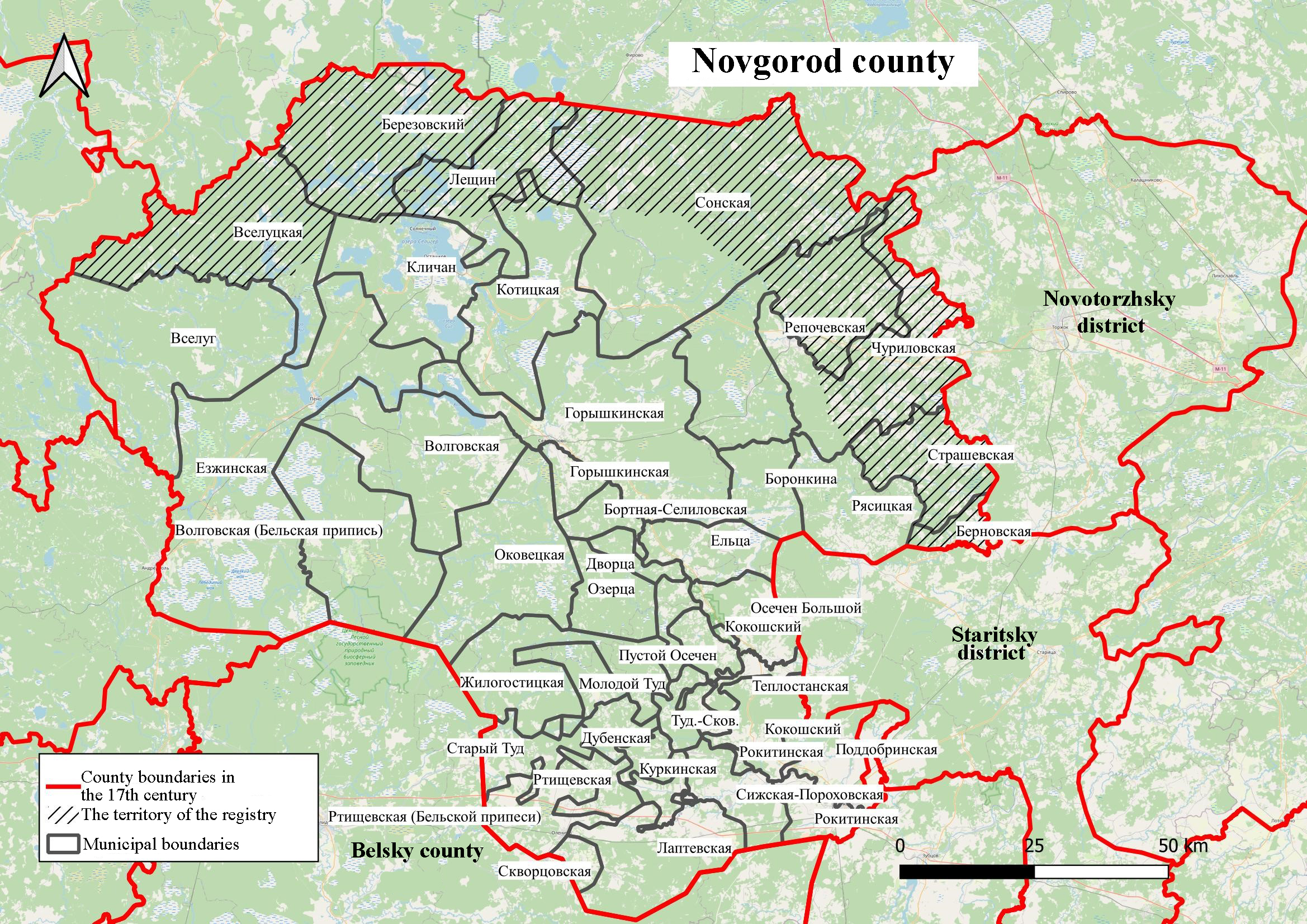
Fig. 1. Map of the Volodimerova Rzheva county volosts in the first quarter of the XVII century. 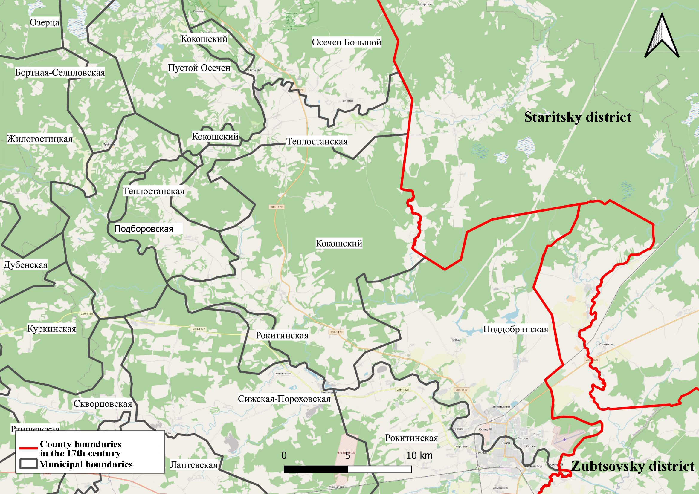
Fig. 2. Map of the municipalities of the southeastern part of the district of Rzheva Volodimerova in the first quarter of the XVII century. 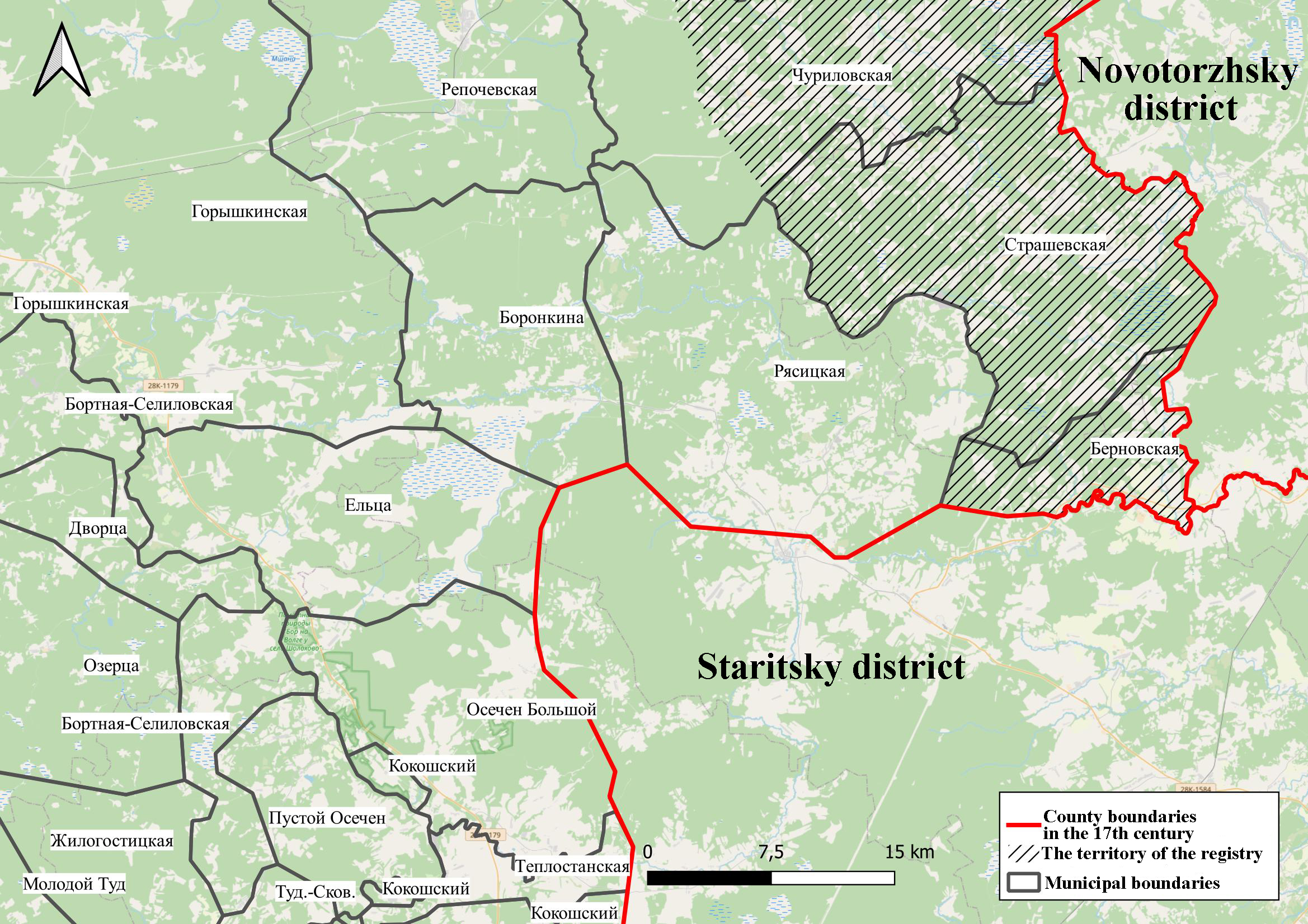
Fig. 3. The map of the Volodimerova Rzheva parish in the eastern part of the district in the first quarter of the XVII century. 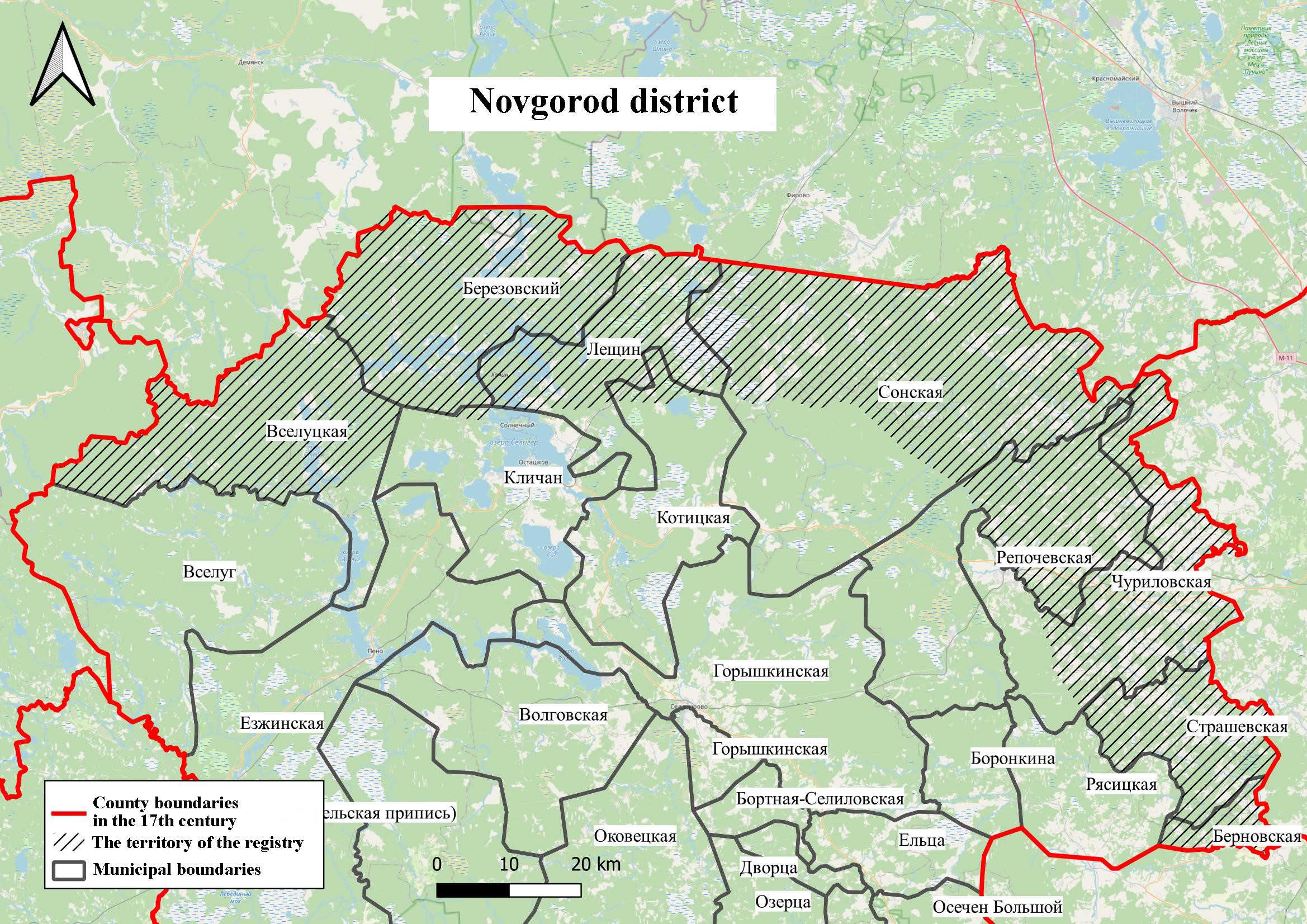
Fig. 4. Map of the municipalities of the northern part of Rzheva Volodimerova county in the first quarter of the XVII century.
References
1. Shapiro, A.L. (1989). The agrarian history of the North-West of Russia of the 17th century: (Population, land ownership, land use). Leningrad: Nauka.
2. Historical acts collected and published by the Archeographic Commission. (1841) Vol. 1. 1334-1598. St. Petersburg.
3. Acts of service landowners of the 15th-erly 17th century. (2002). Vol. III. Moscow.
4. Acts of service landowners of the 15th-erly 17th century. (2008). Vol. IV. Moscow.
5. Acts of feudal land ownership and economy. (1961). 3. Moscow.
6. Antonov, A.V. (2002). Private archives of Russian feudal lords of the 15th-beginning of the 17th century. Russian diplomarium. 8. Moscow.
7. Borzakovsky, V.S. (1876). The history of Tver principality. S-Petersburg.
8. Web GIS "Historical atlas of the Village pyatina of the Novgorod land according to the scribe's book of letters of 1495-1496". Retrieved from http://histgeo.ru/derevskaya.html
9. Vitov, M.V. (1962). Historical and geographical essays of the Zaonezhye region of the 16th–17th centuries. From the history of rural settlements. Moscow.
10. Gotye, Yu. V. (1937). Zamoskovny country in 17th century (2nd issue). Мoscow.
11. Spiritual and contractual letters of the great and appanage princes of the 14th-16th centuries. (1950). Moscow.
12. Kvashnin-Samarin, N.D. (1891). About Zubtsov and Rzhev census books as a source for the study of local history. Tver.
13. The Complete Collection of Russian Chronicles. (2000). Vol. 13. Moscow.
14. Kuchkin, V. A. (1980). Russian principalities and lands before the Battle of Kulikovo. Kulikovskaya battle (pp. 26-113). Moscow.
15. Kuchkin, V.A. (1984). To study the process of centralization in Eastern Europe (Rzhev and its volosts in the 14th-15th centuries). History of the USSR, 6, 149-161.
16. Novgorod first Chronicle. (1950). Moscow; Leningrad.
17. The scribal and boundary book of Rzheva Volodimerov, side of knyaz' Dmitriev Ivanovich pisma and the measures of Iev Nesterovich Lachinov and the clerk Grigory Semenov. 1623/24 -1624/25. Russian State Archive of ancient acts (RSAAA). F. 1209. Op. 1. No. 834.
18. The scribal and boundary book of Rzheva Volodimerov, side of knyaz' Fedorov Borisovich pisma and the measures of Leonty Skobeltsyn and the clark Makar Chukarin. 1623-1625. RSAAA. F. 1209. Op. 1. No. 833.
19. RSAAA. F. 1209. Inv. 1. No. 373.
20. RSAAA. F. 1354. No. 496. Part 1.
21. RSAAA. F. 1354. No. 502. Part 1.
22. RSAAA. F. 1354. No. 503. Part 1.
23. RSAAA. F. 1354. No. 504. Part 1.
24. RSAAA. F. 1354. No. 505. Part 1.
25. Collection of state charters and treaties stored in the State Board of Foreign Affairs. Text. (1813). Part 1.
26. Stepanova, Y.V. (2023). Territorial organization of the end of the 15th-17th century in the Upper Volga and Upper Podvinye: a study using geoinformation technologies. Historical approach in geography and geoecology. (pp. 330-335). Petrozavodsk.
27. Surikov, I.M. (2004). The history of Churilovskaya volost of Novotorzhsky and Rzhevsky uezds in the 16th-18th centuries. Novotorzhsky collection (pp. 176-179). Issue 1. Torzhok.
28. Temushev V.N. (2023). The first Moscow-Lithuanian border war: 1486-1494. Moscow.
29. Topographic boundary atlas of Tver province, compiled in 1848 and 1849 by members of the boundary corps and topography of the military department under the supervision of Major General Mende. (1853). Retrieved from http://www.etomesto.ru /
30. Uezd plans of Rzhevsky, Ostashkovsky, Novotorzhsky counties. Retrieved from http://www.etomesto.ru /
31. Uspensky, V. (1892). Lithuanian border towns of Seluk, Goryshin and others. Tver.
32. Frolov, A.A. (2014). Scribal seasoning book of 1588-1589 of the district of Rzheva Volodimerova (half of knyaz' Dmitry Ivanovich). Moscow; St. Petersburg: Alliance-Archeo.
33. Frolov, A.A. (2006). The status of the lands of the southern borderland of the Novgorod land in the 16th-early 18th century. Essays of feudal Russia (pp. 106-121) Issue 9. Moscow; St. Petersburg: Alliance-Archeo.
34. Frolov, A.A., & Piotukh, N.V. (2008). Historical atlas of the Derevskaya Piatina of Novgorod land (for the scribal books of writing of 1495-1496). Vol. 1-3. Moscow; Saint-Petersburg: Alliance-Archeo.
35. Yanin, V.L. (1998). Novgorod and Lithuania: border situations of the 13th–15th centuries. Moscow.
36. Tikhomirov, M.N. (1979). Russian Chronicle. Moscow: Nauka.
Peer Review
Peer reviewers' evaluations remain confidential and are not disclosed to the public. Only external reviews, authorized for publication by the article's author(s), are made public. Typically, these final reviews are conducted after the manuscript's revision. Adhering to our double-blind review policy, the reviewer's identity is kept confidential.
The list of publisher reviewers can be found here.
In the history of our country, small Rzhev acts as a city with an unusual fate: suffice it to say that today historians propose to put the Battle of Rzhev "with such fateful battles of the Great Patriotic War as the Battle for Moscow, the Battle for Leningrad, the Battle for the Caucasus." A.T. Tvardovsky's poem "I was killed near Rzhev", written during the war, flew all over the country, showing the severity of wartime. In memory of that battle, the Rzhevsky Memorial was opened in 2020, today it is the center of attraction for all those who honor the memory of our ancestors. But at the same time, Rzhev is a city with a long history, originally called Rzhev Volodimirov. These circumstances determine the relevance of the article submitted for review, the subject of which is the territorial and administrative division of the left bank of the Volga River in the district of Rzheva Volodimerova in the first quarter of the XVII century. The author sets out to show the results of mapping the left-bank part of the Rzhev Volodimerov county according to the scribe description of the 1620s, obtained as part of the GIS development. The work is based on the principles of analysis and synthesis, reliability, objectivity, the methodological basis of the research is a systematic approach, which is based on the consideration of the object as an integral complex of interrelated elements. In the section "Methodology and technical solution", the author shows that "similar studies have been conducted in the last decade by a group of researchers from the Faculty of History of Tver State University and the Institute of General History of the Russian Academy of Sciences." The scientific novelty of the article lies in the very formulation of the topic: the author notes that "there has not been a full–fledged idea of the location, size, and population of the Volodimerov Rzhev county volosts in Russian historiography to date," and there was no "detailed map of the left-bank part of the county - the "side of Prince Fyodor Borisovich", made using a modern geographical basis." Scientific novelty is also determined by the involvement of archival materials. Considering the bibliographic list of the article as a positive point, its versatility should be noted: in total, the list of references includes 36 different sources and studies, which in itself indicates the amount of preparatory work that its author has done. The source base of the article is represented by documents from the collections of the Russian State Archive of Ancient Acts, as well as published chronicles and acts. Among the studies used, we will point to the works of Yu.M. Stepanova, I.M. Surikov, A.A. Frolov, whose focus is on various aspects of studying the history of the Rzhev land. Note that the bibliography of the article is important both from a scientific and educational point of view: after reading the text of the article, readers can turn to other materials on its topic. In general, in our opinion, the integrated use of various sources and research to a certain extent contributed to the solution of the tasks facing the author. The style of writing the article can be attributed to scientific, at the same time understandable not only to specialists, but also to a wide readership, to anyone interested in both historical geography in general and the study of the history of the Rzhev land in particular. The appeal to the opponents is presented at the level of the collected information received by the author during the work on the topic of the article. The structure of the work is characterized by a certain logic and consistency, it can be distinguished by an introduction, the main part, and conclusion. At the beginning, the author determines the relevance of the topic, shows that "the question of the volost division and the administrative centers of the Rzhev Volodimerov district in the XV-XVII centuries was repeatedly considered by historians, but the ideas about the location of the Rzhev volosts are still far from complete." In the course of the work, "a detailed localization of the Volodimerov Rzhev county volosts located on the left bank of the Volga River was carried out," as a result of which "the nature of the boundaries of the Rzhev volosts" of Prince Fyodor Borisovich's half"is quite definitely established." The author draws attention to the fact that "the results obtained became the basis not only for clarifying the boundaries of the county of the XVII century, but also for their formation in historical dynamics during the XV-XVI centuries." The main conclusion of the article is that "geoinformation technologies made it possible to perform a detailed reconstruction of the location of the Volodimerova Rzhev county volosts of the first half of the XVII century." For review, the article is devoted to an urgent topic, is provided with a table and 4 figures, will arouse readers' interest, and its materials can be used both in lecture courses on the history of Russia and in various special courses. In general, in our opinion, the article can be recommended for publication in the journal "Historical Informatics".
Link to this article
You can simply select and copy link from below text field.
|
|


