|
MAIN PAGE
> Back to contents
Historical informatics
Reference:
Sokolova E.V., Petrov M.A.
Creation of an interactive map of the disappeared settlements of the Omsk region through the use of GIS technologies
// Historical informatics.
2023. № 4.
P. 1-9.
DOI: 10.7256/2585-7797.2023.4.69046 EDN: SVYPGE URL: https://en.nbpublish.com/library_read_article.php?id=69046
Creation of an interactive map of the disappeared settlements of the Omsk region through the use of GIS technologies
Sokolova Evgeniya Valer'evna
ORCID: 0000-0002-1069-0389
PhD in History
Associate Professor of the Department of Humanitarian, Socio-Economic and Fundamental Disciplines; Omsk State Agrarian University named after P.A. Stolypin
644008, Russia, Omsk region, Omsk, Institutskaya Ploshchad str., 1

|
lev-15@mail.ru
|
|
 |
|
Petrov Mikhail Aleksandrovich
ORCID: 0009-0004-0779-519X
Teacher, Omsk State Agrarian University named after P.A. Stolypin
644008, Russia, Omsk region, Omsk, Institutskaya Ploshchad str., 1
|
|
ma.petrov@omgau.org
|
|
 |
|
DOI: 10.7256/2585-7797.2023.4.69046
EDN: SVYPGE
Received:
20-11-2023
Published:
29-11-2023
Abstract:
The article is devoted to the study of the possibilities of using geographical information systems to study the process of forming a rural settlement network of the territory. The object of the study is the formation of a map of rural settlements of the Omsk region. The subjects of study are the disappeared villages of the Omsk region. The purpose of the study is to show the possibilities of geographical information systems for visualizing the map of disappeared villages. In the course of the work, the authors collected and digitized significant cartographic material reflecting the territory of the Omsk region within modern borders. This made it possible to study and analyze the historical traces of the disappeared villages on maps and plans. The authors consider in detail such issues as the development of an electronic map of rural settlements and an interactive map of disappeared villages, which allows to accumulate information collected from various sources, including non-traditional ones for historical science. On the basis of digitized materials using GIS technologies, a vector electronic map of the Omsk region was formed, on which the historical picture of the formation of the rural settlement network of the territory is reflected in layers. In the course of the study, the authors established the possibilities of systematization and registration of these cartographic materials into a single interactive map of the region with embedded attributive (semantic) data in the form of historical references and photographic materials. The novelty of the research lies in its interdisciplinarity: the use of modern information systems when working with traditional historical sources (cartographic materials) opens up new opportunities for researchers. The experience of developing an interactive map of disappeared villages using geographic information systems is necessary to summarize information and form a general picture of the development of the territory in certain periods of time. The practical significance of the research lies in the fact that the created interactive map allows you to preserve the history of the disappeared villages in a single systematized space, demonstrates new possibilities of historical research. The results of the work will be useful not only to the scientific community, but also to practical teachers who will be able to use the map in their professional activities and involve schoolchildren in work to refine and supplement the map data.
Keywords:
Omsk region, Tara district, geographic information systems, GIS technologies, interactive map, historical map, disappeared village, rural settlement network, rural history, historical computer science
This article is automatically translated.
You can find original text of the article here.
Introduction. At the beginning of the XX century, 87% of the Russian population lived in rural areas. After 100 years, the situation has changed dramatically: according to the Federal State Statistics Service, as of October 1, 2021, there were 25% of the rural population in Russia [Results of the All-Russian Population Census 2020. Change in the population of Russia. URL: https://rosstat.gov.ru/vpn/2020/Tom1_Chislennost_i_razmeshchenie_naseleniy (accessed: 11/15/2023)]. Every year several thousand Russian villages become abandoned, and then disappear from the map of rural settlements of the country. For example, according to the results of the All-Russian Population Census of 2020, 1,471 rural localities were registered in the Omsk region, 59 of them without a population [Results of the All-Russian Population Census of 2020 Change in the population of Russia. URL: https://rosstat.gov.ru/vpn/2020/Tom1_Chislennost_i_razmeshchenie_naseleniy (date of reference: 11/15/2023)]. The study of the causes of the disappearance of rural settlements is of both scientific and practical importance. The results obtained make it possible not only to identify the specifics of the implementation of state policy in a particular territory, but also to predict the further formation of a rural settlement network. Also, the results of the study may be of interest to regional authorities in terms of analyzing the experience of organizing the location and communication of rural settlements. The territorial scope of the study includes the territory of the modern Omsk region, which took shape in 1944. Results. The disappearance of villages is an integral element of the formation of a map of the rural settlement network of any territory. The political and socio-economic characteristics of individual chronological stages largely determined the appearance and disappearance of villages, the way of life and way of life of peasants. The problems of the formation of the rural settlement network of the territory occupy a significant place in modern Russian historiography [2, 3, 6, 8, 9, 12]. Among the reasons for the disappearance of villages, the authors especially highlight the state policy in the field of the agricultural sector of the economy and the natural and geographical factor, which determined not only the economic specifics of the territory, but also the social and living conditions of rural residents. The main reasons for the disappearance of villages in the 1920s and 1930s were the policy of collectivization, remoteness from the center and lack of roads, surrounded by swamps, which limited them to the necessary amount of good arable land. The second period of reduction in the number of rural settlements covers the 1950s and 1960s. He was associated with the policy of enlarging farms and the liquidation of "unpromising villages". The 1990s are another stage in the disappearance of villages. It is connected, first of all, with the entry of the rural population into the market economy. The destruction of collective farms and the emergence of modern organizational and legal forms of management did not allow small villages to integrate into the new system. In addition, the market was quickly captured by large agricultural holdings and joint-stock companies, with which it turned out to be impossible to compete. The reduction in the rural population led to a reduction in social and cultural infrastructure (closure of schools, hospitals, rural clubs); district centers and cities have become especially attractive for young people. The result of these processes in the regional aspect was a significant change in the map of rural settlements of the Omsk region. If, according to the results of the All—Russian Population Census of 2002, there were 1,524 rural settlements in the Omsk region (23 of them without a population) [The results of the All-Russian Population Census of 2002 Change in the population of Russia. URL: http://www.perepis2002.ru/index.html?id=13 (date of reference: 11/15/2023)], then according to the results of the 2020 Census there were 1,471 settlements (59 of them without a population) [Results of the All-Russian Population Census 2020. Change in the population of Russia. URL: https://rosstat.gov.ru/vpn/2020/Tom1_Chislennost_i_razmeshchenie_naseleniy (date of address: 11/15/2023)]. Most of these settlements fall in the northern regions of the region (Ust-Ishim, Tarsky and Znamensky districts). Cartographic materials clearly show the scale of changes. For example, comparing a fragment of the territory of the northern part of the Tarsky district of the Omsk region in a time interval of more than 100 years, we see how many settlements were abandoned during this time (Fig. 1). 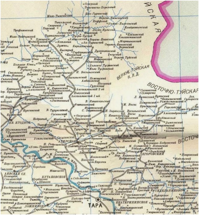
A. Fragment of a map of Tarsky uyezd of Omsk province of the beginning of the XX century 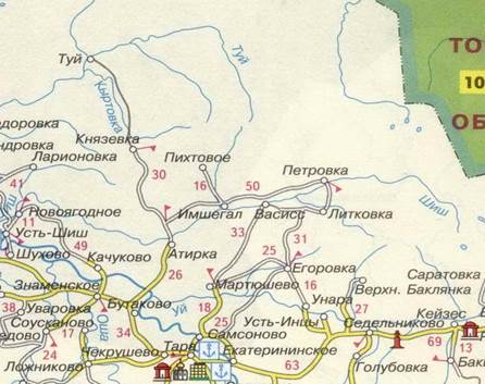
B. Fragment of the map of the modern Omsk region Figure 1. Localization density of rural settlements in the northern part of the Tarsky district of the Omsk region Cartographic materials are one of the informative sources for studying the process of forming a map of rural settlements of the Omsk region in terms of disappeared villages. The cartographic materials collected by the authors of the study, the scale of the disappearance of villages, the new technical capabilities that the researcher receives today, as well as the need for interdisciplinary research led to the need to digitize cartographic material and build a single interactive map of the territory with embedded historical attributive (semantic) data. To implement this task, the technologies of modern geographic information systems (GIS) were used. The use of GIS technologies in historical research is one of the new directions of Russian historical science and has not yet become widespread [1, 4, 5, 7, 10, 11].
A geographic information System (GIS) is a system for collecting, storing, analyzing and graphically visualizing spatial (geographical) data and related information about necessary objects. Maps created using GIS are a new generation of maps that allow you to visualize the past. Not only geographical, but also statistical, demographic, technical and many other types of data can be applied to maps created using GIS technologies and a variety of analytical operations can be applied to them. In addition, using GIS technologies, the researcher gets the opportunity to identify hidden relationships and trends that are difficult or impossible to establish using the usual paper maps. As a result of digitization of terrain maps of various time intervals using GIS technologies, a vector electronic map of the Omsk region was formed within its modern borders, which reflects the historical picture of the urbanization of the population in layers, followed by the desolation of villages and villages. The GIS software interface made it possible to synchronize each layer of the map with a specific year, which made it possible to trace the visual picture of the disappearance of rural settlements, as well as to determine the geographical vector of this process. An important step in the digitization of cartographic material in the framework of the study is the creation of an interactive map of disappeared settlements within the borders of the modern Omsk region on the basis of an already created layered electronic map. Unlike a conventional electronic map, an interactive map will allow you to introduce additional information about reflected objects on the map (in particular, about disappeared settlements). Each locality that has already disappeared from modern maps will have a pop-up interactive tab with a historical description of the village or village collected as part of the study, archival data, photographic materials and other information. Also, the interactive map, if possible, will contain detailed plans of the disappeared settlements themselves. Partially similar plans have been preserved on large—scale maps of the Soviet era, and for settlements that have disappeared since the end of the XX century to the present time, settlement plans can be built using remote sensing materials. For example, for one of the settlements in the north of the Omsk region, the village of Knyazevka of the Tarsky district, which disappeared from modern maps of the Omsk region more than 20 years ago, the outline of the road and street network, land plots and the partial location of houses are clearly traced from satellite images (Fig. 2). 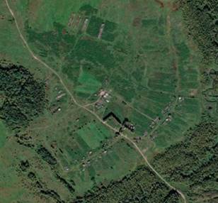
A. Satellite image from the Google Earth geoinformation system 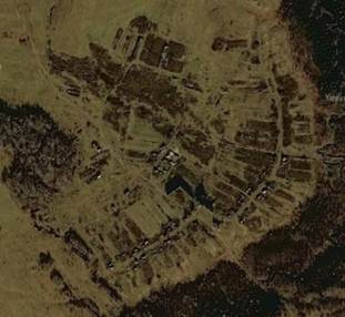
B. Satellite image from the geographic information system Yandex.Maps Figure 2. Satellite images of the neighborhood of D. Knyazevka of the Omsk region As a result of the work on deciphering satellite images from various sources, as well as working with large-scale cartographic material characterizing various time intervals, it is possible to recreate the plan of a village that was abandoned by residents (Fig. 3). 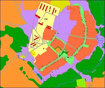
Figure 3. The recreated plan of the abandoned d. Knyazevka of the Omsk region To check the "correctness" of such plans allow the memories of former residents of settlements, who make additional details after reviews of such plans and sometimes even with historical references and memories of residents of houses. Conclusion. The interactive map of the disappeared villages of the Omsk region created as a result with embedded attributive (semantic) data in the form of historical references and materials, photographic materials and with partially detailed plans of the settlement will allow preserving the history of these settlements in a single systematized space. Detailing the layout of villages in combination with the memories of their inhabitants makes it possible not only to recreate the appearance of settlements, but also to reconstruct the life of disappeared villages. The layered presentation of information creates conditions for visualizing the process of forming a map of rural settlements of the territory to establish the factors that determined the appearance and disappearance of villages. The interactive map of the disappeared settlements of the Omsk region, created with the help of GIS technologies, acts as a modern source that allows conducting interdisciplinary research, popularizing the material for a wide range of users, testing new methods of historical research.
References
1. Gammer, E.A., & Revina, I.V. (2015). Possibilities of using geographic information systems in historical research. Applied mathematics and fundamental informatics, 2, 113-117.
2. Zverev, V.A., & Tatarnikova, A.I. (2005). Development of the rural settlement network of Western Siberia in the second half of the XIX–early XX centuries: historiography of the topic. Modern historical Siberian studies of the XVII–early XX centuries: Digest of articles, 92-105.
3. Mazur, L.N. (2003). Ural village in the 1930–1980: main trends in the development of the settlement system. Bulletin of the Russian Humanitarian Scientific Foundation, 4, 14-30.
4. Petrov, M.A., & Bankrutenko, A.V. (2018). Methods for preserving historical and cultural heritage using GIS technologies. Vaganov readings: Digest of articles, 132-136.
5. Rygalova, M.V. (2017). Possibilities of using GIS technologies in studying the formation and development of the museum network of the Altai Territory. Scientific notes (Altai State Academy of Culture and Arts), 3, 28-31.
6. Sokolova, E.V. (2022). Formation of a map of rural settlements of the Russian population of Tara district in the XVI–XIX centuries. Bulletin of Tambov University. Series: Humanities, 5, 1274-1282.
7. Stepanova,Yu.V., & Karpova, M.V. (2023). From scribal books to GIS: the Toropets-Belsko-Rzhev border in the XV–XVII centuries. Historical information science, 3, 58-68.
8. Tatarnikova, A.I. (2013). Network of rural settlements in Western Siberia in the second half of the XIX – early XX centuries: scale and social development. Tobolsk: TKNS Ural Branch of the Russian Academy of Sciences.
9. Usoltseva, O.V. (2018). Rural settlement network of the Tomsk region (1940–1980). Tomsk: DEMOS.
10. Filippova, V.V. (2016). GIS technologies in the study of the history of Yakutia (based on materials from the Subpolar Census of 1926–1927 and the All-Union Census of 1939). North-Eastern Humanitarian Bulletin, 1, 43-46.
11. Frolov, A.A. (2019). «Digital turn» in historical science and historical geoinformatics. Historical information science, 3, 115-123.
12. Churkin, M.K. (2006). Relocation of peasants from the black earth center of European Russia to Western Siberia in the second half of the XIX and early XX centuries: determining factors of migration mobility and adaptation. Omsk: Omsk State Pedagogical University.
Peer Review
Peer reviewers' evaluations remain confidential and are not disclosed to the public. Only external reviews, authorized for publication by the article's author(s), are made public. Typically, these final reviews are conducted after the manuscript's revision. Adhering to our double-blind review policy, the reviewer's identity is kept confidential.
The list of publisher reviewers can be found here.
Review of the article "Creation of an interactive map of the disappeared settlements of the Omsk region through the use of GIS technologies" The subject of the study is the creation of an interactive map of the disappeared settlements of the Omsk region through the use of GIS technologies Research methodology Research methodology is based on the principles of scientific objectivity, consistency and historicism. The methods of modern geographic information systems (GIS) are used in the work. Their application in historical research is one of the new directions of Russian historical science. The author of the article writes that GIS "is a system for collecting, storing, analyzing and graphically visualizing spatial (geographical) data and related information about necessary objects. Maps created using GIS are a new generation of maps that allow you to visualize the past. Not only geographical, but also statistical, demographic, technical and many other types of data can be applied to maps created using GIS technologies and a variety of analytical operations can be applied to them." The work is interdisciplinary in nature. The sources used are cartographic material, memoirs of contemporaries, census materials, photo materials, etc. Relevance. The relevance of the topic is determined by the setting of the topic and tasks. The causes of the disappearance of rural settlements, which have been observed since the 20s of the XX century and are actively continuing in our time, attracts historians, geographers, sociologists, etc. Researchers are interested not only in the causes of the disappearance of settlements, but also in the quantitative and qualitative characteristics of this process, but also spatial. Turning to new GIS information technologies makes it possible to trace how the spatial picture of the region is changing with the disappearance of rural settlements, etc., in this case, the Omsk region. The use of GIS technologies allows the researcher to "identify hidden relationships and trends that are difficult or impossible to establish using conventional paper maps" and show not only economic, political, demographic, etc. reasons, but also to show changes in space, which is difficult to do using traditional methods. Scientific novelty is determined by the formulation of the problem and tasks. The scientific novelty is due to the use of new, but proven effective chemical methods. The novelty also lies in the fact that the author has created, as the author of the reviewed article notes, "an interactive map of the disappeared villages of the Omsk region with embedded attributive (semantic) data in the form of historical references and materials, photographic materials and partially detailed plans of the settlement," which will preserve the history of these settlements in a single systematized space. Style, structure, content. The style of the article is scientific, the language is clear and understandable. The structure of the work is aimed at achieving goals and objectives and consists of the following sections: Introduction; Results; Conclusion and bibliography. The text of the article is presented sequentially. The text is provided with maps and drawings, which makes it more visual and understandable. The bibliography of the work includes 12 sources: these are works devoted to the use of GIS technologies in historical works, monographs and articles on the formation of rural settlements, their socio-economic development and other issues related to the problem under study and related problems. The bibliography shows that the author knows the topic well. The appeal to the opponents is presented at the level of the information received during the work on the topic under study and the bibliography. Conclusions, the interest of the readership. The article will be of interest to specialists, as well as to a wide range of readers (students, postgraduates), especially those who are interested in the use of GIS technologies in historical research, etc.
Link to this article
You can simply select and copy link from below text field.
|
|


