|
DOI: 10.7256/2585-7797.2023.3.48496
EDN: XEHGVZ
Received:
05-10-2023
Published:
12-10-2023
Abstract:
The article presents the results of studying the regions located on the western boundary of the Russian state of the XVI-XVII centuries. The object of the study is Toropetsky Uyezd and its eastern volosts - Dubna, Rozhna, Bibirevo and Startsova, which in the XV century formed the Moscow-Lithuanian border. Territorial transformations of these volosts in the XV-XVII centuries are considered. Based on written sources, the GIS localization of the border between Toropetsky, Belsky and Rzhevsky counties, the most important in the study of border situations during the XV-XVII centuries, was carried out. The main sources of the study are scribal descriptions of Toropetsky, Belsky, Rzhevsky counties of the XVI-XVII centuries, including previously unpublished and introduced into scientific circulation. The study was conducted using geoinformation technologies. The use of geoinformation technologies in the work on the continuous localization of toponyms of scribal descriptions of three counties allowed us to get a more detailed idea of the territory of the Toropetsky district before its entry into the Russian State. Startsova Parish stretched south from Toropets to the large Peletsky Moss swamp. Its southeastern part, lying on the left bank of the Western Dvina, was assigned to Belaya even before Toropets and Belaya joined Moscow. Rozhnya and Bibirevo in the 1520s and 1530s also went to Moscow. Finally, Dubna changed its size and status as a result of the border conflicts of the XV century and land policy in Russia of the XVI-XVII centuries. The location of the Zhukopsky pit marking the road crossing the Moscow-Lithuanian border has been established.
Keywords:
historical geography, GIS, borders, uezd, cadastral books, volost', Russia, Grand Duchy of Lithuania, road, Toropets
This article is automatically translated.
You can find original text of the article here.
Geoinformation technologies have been used in domestic historical and geographical research for more than 20 years [26]. Especially productive was the use of GIS in working with the materials of the General Survey of the XVIII–XIX centuries, which are of great importance in the study of socio-economic history and historical geography of Russia not only in Modern times, but also in the late Middle Ages. The study of the materials of the General Survey showed its productivity, first of all, in reconstructions of the rural settlement system. The main provisions of the localization methodology of settlements of the XV–XVII centuries. on the basis of these sources of the XVIII–XIX centuries were formulated by A.M. Andriyashev [4] and M.V. Vitov [9]. In this approach, the data of the General Surveying of the XVIII century are a kind of "key" to the localization of the data of the land descriptions of the XV–XVII centuries on a modern geographical basis. The introduction of geoinformation technologies in the 2000s made it possible to process large arrays of historical and geographical information from sources of the Late Middle Ages and early Modern times. In addition to speeding up the process of statistical processing of land descriptions, technologies have made it possible to create historical and geographical geoinformation projects equipped with a set of scaling functions, full-text data search, distance and area measurements. Linking the materials of the General Surveying in such projects made it possible to reflect the direct sources of geographical information for reconstructions of the historical landscape of the XV–XVII centuries. In this methodological field, the project of A.A. Frolov and N.V. Piotukh was carried out to localize more than 6 thousand villages of the oldest Russian scribe book of the Village Pyatina of the Novgorod land of the end of the XV century [31], and later joint projects of Tver State University and the Institute of General History of the Russian Academy of Sciences on the historical geography of certain areas of the Upper Volga region: Bezhetsky Top [30], Tver District [8], Tver half of Bezhetsky Pyatina [7]. It seems productive to use geoinformation technologies in studying the dynamics of borders (primarily international ones) and territories that have been subjected to multiple repartitions. In the history of Russia, one of these territories is Toropetskaya Land. Toropetsky volosts were Toropetsky municipality as part of the XIV–XV centuries and Toropetsky county as part of the Russian state of the XVI–XVII centuries. L.A. Bassalygo and V.L. Yanin drew attention to the differences in the composition of Toropetsky volosts according to the charters of the second half of the XV century and the scribe book of the county of 1540 [5, pp. 192-193]. V.N. Temushev traced the chronology of military clashes on the Rzhev-Toropetsky border in the 1480s - 1490s and created a map of the Toropetsky district at the end of the XV century, on which he schematically reflected parts of the district, including those attached to the Principality of Belsky and Rzhevsky county [22, map 5; 23]. Historical and geographical studies of the areas of contact of the Moscow Principality, INCL. and Novgorod land belong to V.S. Borzakovsky [6], N.D. Kvashnin-Samarin [13], L.V. Alekseev [3], V.A. Kuchkin [14], A.A. Frolov [25; 27; 28]. Continuous localization of the toponymy of scribal descriptions of the XVI–XVII centuries with the use of geoinformation technologies allows us to reflect the realities already known to historians on a modern digital cartographic basis, as well as to form a more detailed idea of the territory of the county, its transformation in the XV–XVII centuries. the Moscow-Lithuanian border, which in the XV century was formed by the eastern volosts of the Toropetsky district. The main sources of research are scribal descriptions of the XVI–XVII centuries. The earliest is the scribe book of the Toropetsky district of 1540 [16; 19; 24]. The next in time is the description of the county of 1626-1629, covering the local and church-monastery lands [18]. To localize the Toropetsky volosts assigned already in Moscow time to the Belsky Uyezd, data from the scribe book of the Belsky Uyezd of 1668 were used [17]. This is the earliest description of the county, covering its entire territory, compiled shortly after the final entry of Belaya into the Russian state. The territory of Dubna parish on the Toropetsk-Rzhev borderland is reflected in the scribe book of the Rzhev Volodimerov county in 1588/89 [29]. Valuable information on the historical geography of the Toropetsk-Rzhev borderland is contained in an extract from the scribe description of the palace volosts of the Rzhev district in 1678, preserved in a copy of the XVIII century. [20]. The volosts of Toropetsky county, according to the scribe book of 1540, were previously localized by the authors of this article within the framework of the gis project. The study used the method of continuous localization using the materials of the general surveying of the second half of the XVIII century. and cartographic materials of the XIX century. [12]. The idea of Toropets land before Toropets was annexed to the Moscow state is given by the truce charter of 1503 [21, pp. 398-402], as well as a number of charters of the 1480s-1490s. The municipalities of Dankovskaya, Kazarinskaya, Lyubutskaya, Turskaya, Startsova, Nevelskaya, Dubna, Rozhnya, Bibirevo, Velizhskaya, Plavetskaya, Ozerskaya and Zhizhetskaya were drawn to Toropets. The last six volosts were not included in the earliest scribe description of Toropetsky county in 1540 . Velizh, presumably, could belong to Toropets county only in the 1520s-1530s. Zhizhetskaya, Ozerskaya and Plavetskaya volosts, located to the west and southwest of Toropets, according to L.A. Bassalygo and V.L. Yanin, did not belong to Toropets district in Lithuanian time [5, p. 190]. Accordingly, the volosts of Dankovskaya, Kazarinskaya, Lyubutskaya, Turskaya, Startsova, Nevelskaya, Dubna, Rozhnya and Bibirevo can be considered Toropets volosts proper in the last decades of Toropets being part of the INCL. The volosts located to the east of Toropets, on the Rzhev-Toropetsky and Belsko-Toropetsky borderlands – Startsova, Dubna, Rozhnya and Bibirevo, underwent the most noticeable transformations. The involvement of scribal descriptions of Belsky and Rzhevsky counties adjacent to Toropetsky made it possible to trace their territorial changes.
The territory of Startsova Volost, according to L.A. Bassalygo and V.L. Yanin, was divided between Toropets and Belaya back in Lithuanian times [5, pp. 192-193], but when exactly remains unclear, perhaps during the aggravation of border conflicts in the 1480s - 1490s. The Scribe Book of Toropets county 1540 gives an idea of the Toropetsky part of the parish. Its administrative center was located in Pogue. Antiquity (in spatial proximity to the city of Western Dvina, Tver region). As part of the Belsky Uyezd in the XVII century, the Starkovskaya volost was preserved, which was obviously assigned to the White part of the Startsova Volost. Reconstruction of its territory is possible according to the scribe book of the Belsky district of 1668 . 60 settlements (1 village, 2 villages, 37 villages, 20 wastelands) belonging to six landholdings are described in the parish [17, l. 12-25]. The Belsky part of the Startsova Volost covered the course of the Velesa River. Its eastern border was located in the marshy interfluve of the Velesa and Mezhi rivers. Thus, the data of descriptions of two counties of the XVI–XVII centuries allow reconstructing the location and size of the Startsova Volost before its division (Fig. 1). 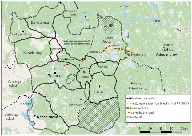
Fig. 1. Toropetsky povet in the XV century. (until the end of the 1480s). It can be assumed that it existed within such territorial boundaries until the end of the XV century. In addition, in the scribe's book of 1540, a cluster of settlements is found, attributed to the Startsova Volost, but surrounded by the Toropetskaya lands. Thus, it can be assumed that initially the Startsova parish extended north to the Zimetsky Lake. The large size of the parish before its division is comparable to the area of such formations as Zhizhetskaya, Ozerskaya volosts. In Lithuanian times, the population of Startsova Volost probably maintained relative independence in relation to Toropets. This is reflected in the documents of the office of the Grand Duke of Lithuania Alexander Jagiellonchik of the 1490s, addressed to the Toropetsky governor, Toropchans and residents of the Startsova volost, which recorded the independent collection of duties in the Startsova Volost and prescribed "not to join the social Toropetsky and Toropchan" [1, pp. 179-180, 394]. In the XVI century. toropetskaya part of the parish remained the area of settlement of the black-collar peasantry. The volosts of Rozhnya and Bibirevo are listed among the Toropets volosts in 1503 and 1523 [2, pp. 148-151], but are absent in the scribe book of 1540. The location of the centers of the volosts did not cause doubt among researchers, while there was no detailed idea about their size and movement between counties. L.A. Bassalygo and V.L. Yanin suggested that The volosts were, like half of Startsova, assigned to the White [5, p. 192]. However, this happened, as we see, already in Moscow time, in the 1520s-1530s. The text of the scribe book of the Belsky district of 1668 helps to solve the problem of their detailed localization, as in the case of the Startsova Volost. Rozhinskaya volost is found in its composition [17, p. 41ob. –49ob.]. It occupied a small territory, which included the course of the Rozhni River (Fig. 2). 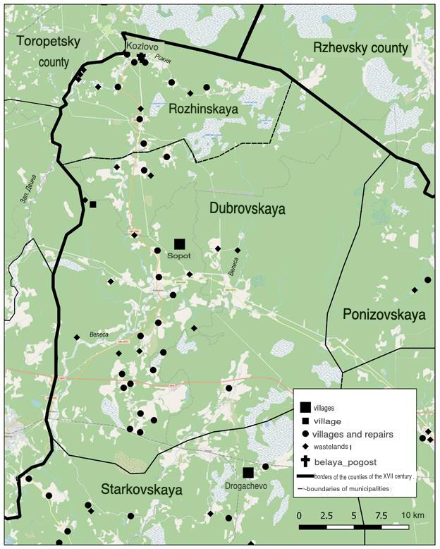
Fig. 2. The volosts of Rozhnya and Bibirevo (Dubrovskaya) as part of the Belsky Uyezd according to the scribe book of 1668. The territory of the Bibirevskaya volost obviously corresponded to the Dubrovskaya volost of the Belsky Uyezd, described in the scribe's book of 1668 [17, l. 25ob. -41]. It covered the upper course of the Velesa River. 58 toponyms are attributed to it (1 village, 2 villages, 26 villages, 2 repairs and 27 wastelands). The village of Bibirevo is not mentioned in the book of 1668. The scribal materials of the Rzhev Volodimerov district of the XVI–XVII centuries do not allow us to identify parts of the Rozhnya and Bibirevo volosts among the Belsky attributions to the county. Dubna parish underwent significant territorial transformations in the XV-XVII centuries. It was first mentioned in 1480 as an area of land ownership of the Vitebsk boyars [15, p. 373]. In 1489, Vasily Davydovich, the governor of the Vselutsky volost of the Rzhev land, seized and cut off half of the Dubna volost from the Toropetsky district. Thus, until 1489, this parish had a larger territory than recorded by the scribe's book of 1540 [5, p. 190]. In the letter of truce of 1503 Dubna is called a parish, but in the scribe's book of 1540 It appears, rather, as a generalizing name for the cluster of settlements. V.N. Temushev performed the reconstruction of the part torn away from Dubna, shown on the map as a small area between the course of the Pavinitsa (Paynitsa) rivers and the Bolshoy and Maly Studenets lakes. The researcher failed to identify only the Polyanitsa river [22, pp. 115-116]. Meanwhile, this river (Polyanitsa, Polyanka) flows into the lake. Kolpino from the north. Thus, the rejected territory can be presented in a little more detail. In the second half of the XVI century. Dubna was assigned to the neighboring county of Rzhev Volodimerov and became part of the Yezzhinsky parish. The inscription could have occurred during the transfer of the Rzhevsky district to the Oprichnina [27, p. 60-61]. Yezzhinskaya (Yazzhinskaya) volost is characterized in the scribe book of the Rzhevsky uyezd of 1588-1589. letters of A.E. Saltykov [29, L. 389-397]. It included the area of the former Dubna and was surrounded by the lands of the Volga parish, located between the lakes Peno, Sig and Volga, as well as the right bank of the Volga from Lake Peno to Lake Volga (Fig. 3). 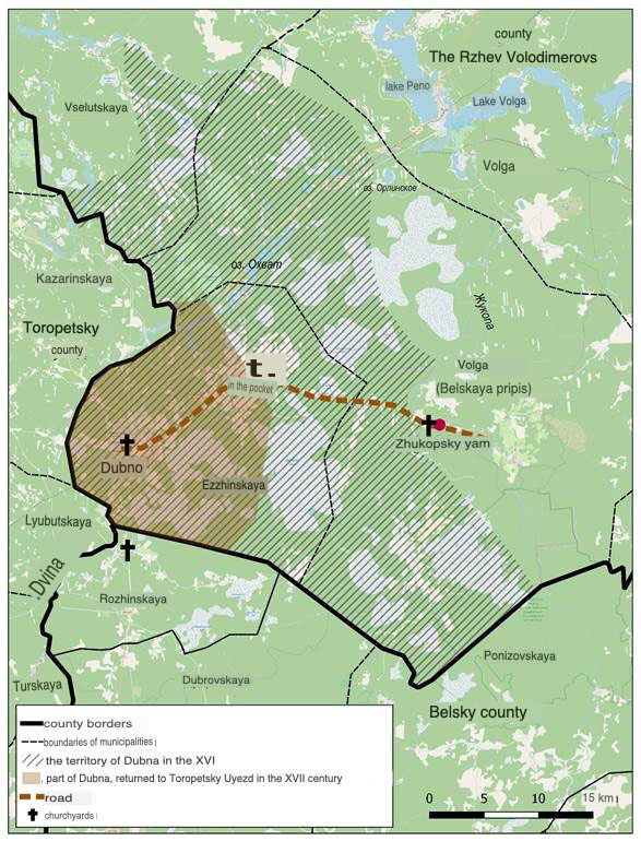
Fig. 3. Dubna parish in the XVI-XVII centuries. Part of the Volga volost was for some time part of the Belsky Uyezd, since in the scribe book of the Rzhevsky Uyezd of 1588-1589, its Belsky inscription stands out (this was pointed out by Yu.V. Gauthier) [11, pp. 396-397]. Among the settlements of the Yezzhinsky parish, toponyms of Dubna are found, known from the previous description, including the churchyards of Dubno and in Luzekh.
In the future, the enclave "in Dubna" is again recorded as part of Toropetsky Uyezd in the scribe book of 1626-1629 [18, l. 205–206ob.], while "in Lusekh" remained as part of the Rzhev Uyezd. Probably, the return of Dubna to the Toropetsky district occurred shortly after the Time of Troubles. It became part of the large Kazarinsky parish, which occupied almost the entire northern half of Toropetsky County. At the same time, the name of the cluster of settlements "in Dubna" has been preserved. The eastern borders of the parishes of Dubna, Rozhnya, Bibirevo formed the Toropetsky section of the Moscow-Lithuanian border, repeatedly reflected in the charters of the XV century. This boundary was studied in detail and localized by V.N. Temushev [22, pp. 110-116]. It extended from oz. Orlinets to the upper reaches of the river . Osugi (a tributary of the Vazuza River) and passed through a swampy area along the course of the Zhukopa River. In Dubna, the boundary passed, apparently, directly along the course of the Beetle. There was also a Zhukopsky pit, which is mentioned in the "Extract from the Novgorod exile books" [10, p. 285]. His whereabouts were not established earlier. It is indirectly indicated by the mention of the road "that they go to Rzheva and Toropets" in an extract from the scribe book of Fyodor Izvedinov and the clerk Fyodor Bishov in 1678 [20, l. 109ob.]. The description describes the palace Molodotudskaya, Zhukopovskaya and Okovetskaya volosts. The road from Toropets to Rzheva Volodimerova crossed the Zhukopa River in the dd area. Lavrovo, Minkino (currently exist), Gorki, empty. Dubasovo. It can be assumed that the Zhukopsky pit on the Moscow-Lithuanian border was located here. Undoubtedly, the road from the Zhukopsky pit passed in the direction of the Dubno churchyard through the churchyard to Luzekh. Other Toropetsky sections of the road are localized on the basis of mentions of the "big" road in the scribe book of the Toropetsky district of 1626-1629 [18, L. 525-526, 570, 571]. It took place in the Kudinsky parish to the north of the lake. Kudino through the territory of the former Lashirskaya boulevard. Another segment was located in Lyubutskaya volost in the area of the Bezdetka and Lososna rivers. In general, the existing railway connecting the cities of Toropets and Andreapol runs in this direction. The use of geoinformation technologies in the work on the continuous localization of toponyms of scribal descriptions of three counties allowed us to get a more detailed idea of the territory of Toropetsk land before its entry into the Russian State. Startsova Parish stretched south from Toropets to the large Peletsky Moss swamp. Its southeastern part, lying on the left bank of the Western Dvina, was assigned to Belaya even before Toropets and Belaya joined Moscow. Rozhnya and Bibirevo in the 1520s and 1530s also went White. Finally, Dubna changed its size and status at the end of the XV century as a result of the border conflicts of the XV century and land policy in Russia of the XVI–XVII centuries. The eastern border of the Toropetsky district of the XV century formed the Moscow-Lithuanian border, which is quite accurately localized on the modern map. Passing mainly through impassable swampy terrain and shallow rivers, this boundary undoubtedly had points of intersection with roads. One of these points was the Zhukopsky pit, the location of which is set in the place where the border passed directly along the Zhukop River. The established location of the pit allows you to trace the direction of the Toropetsky section of the road that crossed the Moscow-Lithuanian border. The settlements located on this site require further research, as in written. And according to archaeological sources, in order to deepen the historical context, clarify the chronology of the corresponding settlements along the way.
References
1. Acts, related to the history of the Western Russia, 1(16): Collection of documents of the Office of the Grand Duke of Lithuania Alexander Jagiellonchik, 1494–1506 (2012). Мoscow; S-Petersburg.
2. Acts, related to the history of the Western Russia (1848). Vol II. S-Petersburg.
3. Alekseev, L.V. (1980). Smolensk land in 9th-13th centuries. Moscow, Nauka.
4. Andriyashev, A.M. (1930). The map of Obonezhskaya oyatina with list of parishes (269-270). Cadastral books of obonezhskaya pyatina of 1496 и 1563: Matrerials of the history of ethnic groups of the USSR, 1. Leningrad.
5. Bassalygo, L.A., & Yanin, V.L. (1998). Historical geographical issue of the Novgarod-Lithuania border. In V.L. Yanin, Novgorod and Lithuania. Border situations in 13th-15th centuries, pp. 104-214. Мoscow, Nauka.
6. Borzakovsky, V.S. (1876). The history of Tver principality. S-Petersburg.
7. Web-GIS «Historical atlas of the Bezhetskaya pyatina (Tver half) of the Novgorod land of the end of 15th-17th century». Retrieved from https://histgeo.nextgis.com/resource/2337/display?panel=layers&fbclid=IwAR2ISUHSpuLDRUxtOhx9nL_zZs_E_k9LhUVzBT8Cj8frkO08g8kk0czBrX4 4.
8. Web-GIS «Tverskoy uezd in 16th century». Retrieved from http://histgeo.ru/tver.html
9. Vitov, M.V. (1862). Historical and geographical essays of the Zaonezhye region of the 16th–17th centuries. From the history of rural settlements. Moscow.
10. Golubtsov, I.A. (1950). The communication routes in the former lands of Novgorod the Great in the 16th-17th centuries and their reflection on the Russian map of the middle of the 17th century (271-302). Questions of geography, 20: Historical Geography of the USSR.
11. Gotye, Yu. V. (1937). Zamoskovny country in 17th century (2nd issue). Мoscow.
12. Karpova, M.V., Stepanova, Y.V. (2020). Historical-geographical research of the Toropetskiy uezd of the 16th century usind the GIS tekhnology. Historical research in the context of data science: information resources, analytical methods and digital technologies, International Conference Proceedings (278-284). Moscow, Maks Press.
13. Kvashnin-Samarin, N.D. (1887). The research of the history of the Rzhevskoe and Fominskoe principalities. Tver.
14. Kuchkin, V.A. (1984). Land surveying in 1483 and the question of the old Novgorod-Smolensk border (165-176). Novgorod Historical Collection. Issue 2(12).
15. Lithuanian metric. Department one. Part One: The book of records. Volume One, 1910. Russian Historical Library, published by the Imperial Archeographic Commission. Volume 27. St. Petersburg.
16. Baranov, K.V. (Ed.). (2004). Scribal book of Toropetsky district letters of Alexander Davydovich Ulyanin and Timofey Stepanov son Bibikov (501-682). Scribal books of Novgorod land. Vol. 4: Scribal books of the Derevskaya pyatina of the 1530s – 1540s. Moscow, Drevlekhranishche.
17. Russian State Archive of ancient acts (RSAAA). F. 1209. Inv. 1, part 1. No 597.
18. RSAAA. F. 1209. Inv. 1, part 1. No 888.
19. RSAAA. F. 137. Toropets. No 1.
20. RSAAA. F. 396. Inv. 2, part 5. No 3598.
21. Collection of the Imperial Russian Historical Society (1882). Vol. 35. S-Petersburg.
22. Temushev, V.N. (2013). The first Moscow-Lithuanian berder war: 1486-1494. Мoscow: Kvadriga.
23. Temushev, V.N. (2006). Тaropetska volast' (659-670). Grand Duchy of Lithuania: encyclopedia. In 2 vv. Vol. 2. Мinsk.
24. Tikhomirov, M.N., Florya, B.N. (Ed.). (1964). Toropetskaya book 1540 (279-357). Archaeographic Yearbook for 1963. Moscow.
25. Frolov, A.A. (2013). Volosts of Buytsy and Lopastitsy: the experience of correlating the toponyms of the search book of 1562 with the information of the cadastr of 1495-1496 and the problem of the pre-Moscow land cadastre (153-201). Essays of feudal Russia, 16. Moscow: S-Petersburg.
26. Frolov, A.A. (2013). Geoinformation technologies in modern historical and geographical studies of Russian historians (447-458). Questions of geography.
27. Frolov, A.A. (2013). New materials on the medieval historical geography of the lands of Rzheva Volodimerova (55-86). Tver State University Bulletin. Series: History, 3.
28. Frolov, A.A. (2013). New materials on the medieval historical geography of the lands of Rzheva Volodimerova (End) (77-89). Tver State University Bulletin. Series: History, 4.
29. Frolov, A.A. (2014). Scribe book of 1588-1589 of Rzheva Volodimerova uezd (half of Prince Dmitry Ivanovich). Moscow; Saint-Petersburg, Aliyans-Arkheo.
30. Frolov, A.A., & Golubinsky, А.А. (2014). Historical GIS «Sources of the historical geography of the Bezhetsky Verkh (146-148). History and Computer Association Newsletter, 42.
31. Frolov, A.A., & Piotukh, N.V. (2008). Historical atlas of the Derevskaya Piatina of Novgorod land, Moscow; Saint-Petersburg, Aliyans-Arkheo, Vol. 1-3.
Peer Review
Peer reviewers' evaluations remain confidential and are not disclosed to the public. Only external reviews, authorized for publication by the article's author(s), are made public. Typically, these final reviews are conducted after the manuscript's revision. Adhering to our double-blind review policy, the reviewer's identity is kept confidential.
The list of publisher reviewers can be found here.
Review of the article “From scribal books to GIS: Toropetsko-Belsko-Rzhevsky frontier in the XV-XVII centuries.” The subject of the study is indicated in the title of the article and explained by the author in the test.The research methodology is based on the GIS methodology, which has become quite widely used by researchers over the past 20 years. The author notes that “The use of GIS in working with the materials of the General Survey of the XVIII–XIX centuries, which are of great importance in the study of the socio-economic history and historical geography of Russia, not only of Modern times, but also of the late Middle Ages, has become especially productive. The study of the materials of the General Survey showed its productivity, first of all, in reconstructions of the rural settlement system.”THE relevance OF THE STUDY IS DUE TO THE FACT THAT the use of geoinformation technologies for the accidental localization of toponymy of scribal descriptions of the XVI–XVII centuries. “it allows us to reflect the realities already known to historians on a modern digital cartographic basis, as well as to form a more detailed picture of the territory of the county, its transformation in the XV–XVII centuries. the Moscow-Lithuanian border, which in the XV century was formed by the eastern volosts of the Toropetsky district.”The scientific novelty of the study lies in the fact that the use of geoinformation typologies for the study of scribal descriptions will allow you to get a more accurate and detailed idea of the boundaries, to show these boundaries on modern maps using histotechnologies. Style, structure, content. The style of the article is scientific, the language is precise, clear and this allows not only the specialist, but also a wider range of readers to understand the topic under study. The structure of the work is aimed at achieving the goals and objectives of the study. At the beginning of the article, the author writes about the prospects of using histotechnologies to study the topic. He gives examples of the use of histotechnology by researchers and shows what results they have achieved and what prospects histotechnology provides, which questions it helps to uncover. He notes that histotechnologies make it possible to process “large arrays of historical and geographical information from sources of the late Middle Ages and early Modern Times.” Histotechnologies help, in addition to “speeding up the process of statistical processing of land description data”, make it possible to “create historical and geographical geoinformation projects equipped with a set of scaling functions, full-text data search, distance and area measurements” and much more. The bibliography of the work consists of 31 sources. Among them are the works of Frolov A.A. and his colleagues, who show the effectiveness of the use of histotechnologies. The bibliography is diverse and fully shows that the author of the article is well versed in the topic and therefore the content of the text of the article is informative and the topic is disclosed in depth and comprehensively. The text of the article is logically structured and presented consistently and clearly. The article is provided with two drawings, which makes the text more visual and understandable.At the end of the article, the author provides objective conclusions. The appeal to the opponents is presented at the level of the work done by the author and the appeal is also presented in the bibliography.Conclusions, the interest of the readership. The article is written on an urgent topic, has all the signs of scientific novelty, will arouse great interest among specialists, as well as students and postgraduates, and will help in the preparation of lectures and reports.
Link to this article
You can simply select and copy link from below text field.
|