|
MAIN PAGE
> Back to contents
Historical informatics
Reference:
Korsakov S.A.
Virtual reconstruction of the main house of the Sennitsy estate situated in Moscow region: sources and research methods
// Historical informatics.
2023. № 2.
P. 79-101.
DOI: 10.7256/2585-7797.2023.2.43472 EDN: SJKCWS URL: https://en.nbpublish.com/library_read_article.php?id=43472
Virtual reconstruction of the main house of the Sennitsy estate situated in Moscow region: sources and research methods
Korsakov Semen Andreevich
Student, Historical Information Science Department, Lomonosov Moscow State University (MSU)
119991, Russia, Moscow region, Moscow, Lomonosovsky Prospekt str., 27, of. G-423

|
semen_korsakov373@mail.ru
|
|
 |
Other publications by this author
|
|
|
DOI: 10.7256/2585-7797.2023.2.43472
EDN: SJKCWS
Received:
01-07-2023
Published:
14-07-2023
Abstract:
The problem of historical and cultural heritage preservation is very relevant these days. Increasing number of monuments is being destroyed every day; however, our compatriots are continuously becoming more interested in landmarks Russia. There has been a marked increase in the number of tourist routes in Moscow region. Numerous noble estates represent an important part of the region’s cultural assets. In Moscow region, there are lots of former estates of prominent families of the Russian Empire: today many of these properties are in ruins. Manor Sennitsy situated in Ozyory district of Moscow region is one of such gradually decaying cultural monuments with a rich history. This study analyzes a set of sources, on the basis of which the author creates a virtual 3D-reconstruction of manor Sennitsy in the period of late 19th – early 20th century when it was owned by the family of Count F.E. Keller. The source base for the study is very diverse: plans, drawings, cartographic materials, photographs, inventories of property, construction cost estimates. The author describes gradual process of 3D-modelling, in the framework of which softwares SketchUp and Twinmotion were used. Reconstruction of buildings of the Sennitsy manor complex allows to visualize an image of the destroyed monument of culture, as well as to demonstrate high potential of using 3D-modelling methods in history. This study is carried out within the framework of the Project of reconstruction of appearance of the noble estates of the Moscow region, supported by the Department of Historical Information Science of the Faculty of History of M.V. Lomonosov Moscow State University.
Keywords:
manor, noble estate Sennitsy, F E Keller, cultural heritage, Moscow region, source study aspects, 3D modelling, virtual reconstruction, visualisation, colourisation
This article is automatically translated.
You can find original text of the article here.
Introduction In the first issue of 2023 of the journal "Historical Informatics", the article "Virtual reconstruction of the buildings of the Sennitsa estate near Moscow: sources and research methods" was published [6], in which the author of the work described the process of 3D modeling of the service wing on the territory of the Sennitsa estate. In this article, along with the description of the sources necessary for the reconstruction of the wing and the consideration of 3D modeling methods of the wing, the history of the Sennitsa estate complex was described in detail. Continuing this work, implemented as part of the project of the Department of Historical Informatics of the Faculty of History of Lomonosov Moscow State University to recreate the appearance of noble estates in the Moscow region, the author turned to the task of virtual reconstruction of the main house of the Sennitsa estate, built at the turn of the XIX – XX centuries in the style of English Gothic of the Victorian era by order of the family of Count F.E. Keller. This article examines in detail the source base necessary for the virtual reconstruction of the main house of the Sennitsa estate (plans and drawings, cartographic materials, photographs and pictorial sources, descriptive sources), after which the process of 3D modeling of the main house with the characteristics of the selected software - SketchUp and Twinmotion is described. Our article [6] gives a detailed description of the history of the owners of the estate, which since 1886 belonged to the family of Count F.E. Keller. Here we will give a very brief excerpt from this story. Since the XVI century, various noble noble families – Gagarins, Vielgorskys, Shakhovskys, Kellers - owned the Haylofts. The heyday of the Sennitsa estate came at the turn of the XIX – XX centuries, when the possessions in the Zaraisk district of the Ryazan province belonged to the Kellers. Russian Russian Lieutenant General Fyodor Eduardovich Keller (1850-1904) was a hero of the Russo-Turkish War of 1877-1878 and the Russo-Japanese War of 1904-1905, in the latter of which he died in battle at the Yanzelinsky Pass. In the period between the two wars, the count was the director of the Page Corps, then he was governor of Yekaterinoslav. His wife, Maria Alexandrovna Keller (1861-1941), nee Shakhovskaya, was the hereditary owner of the lands in Sennitsy. Archival documents show what careful reporting was carried out at the Sennitsa estate under the Countess [7]: all expenses were calculated in detail, monthly purchases of provisions were recorded, a list of the staff of the estate employees was kept, etc. Maria Alexandrovna was actively engaged in charitable activities, having done a lot for the Sennitsa peasants: a nursery, a school were built at her expense in the village, a shelter, a hospital, a zemstvo school. Under the Kellers, according to the project of architect A.N. Ageenko, the estate was reconstructed in the style of English Gothic of the Victorian era; a luxurious red-brick mansion and office buildings fitting into the overall composition were erected. The construction works were supervised by Zaraisk architect A.F. Kruger. Sources for creating a virtual reconstruction The original project of the architect A.N. Ageenko, prepared as part of the restructuring of the estate under the Kellers, probably has not been preserved. At least, the long archival work to find the original drawings of the Keller mansion was not crowned with success. The inventories of the funds of the RGVIA, RGADA, RGIA, GARO, CGA Moscow, TSGAMO, which to one degree or another correlate with the personality of the owners of the Sennits, were studied. However, dimensional drawings of the preserved buildings of the estate were found, prepared by the All-Union Industrial Scientific and Restoration Combine (VPNRK) of the USSR Ministry of Culture (now the Central Committee of the Ministry of Culture of the Russian Federation) in the late 1970s - 1980s. A lot of scientific and technical documentation necessary for virtual reconstruction was found in the TSNRPM archive in the fund No. 283 ("Sennitsa Manor"). The most valuable materials are plans and dimensional drawings of outbuildings, power plant buildings, greenhouses, tombs, bridges across the bayou. These materials were carefully prepared by the VPNRC research group. Dimensional drawings of all 4 facades of buildings were made, plans of the 1st and 2nd floors were prepared. The main objectives of this work were to create a model of the main wing and the main house of the Kellers. Therefore, from the above-mentioned materials, only dimensional drawings and floor plans of the wing were used [13]. As for the main house of the Kellers, the virtual reconstruction of which is at the center of the work, no dimensional drawings for it were found in the archive of the Central Research Institute. In the 1980s, the research group could not prepare such documentation, since the building completely burned down in the 1920s. However, it was possible to find a number of important documents that allow restoring the layout of the mansion and its dimensions. Employees of the VNRK in 1979 [12], then in 1981-1982 [11]. conducted archaeological excavations of some fragments of the foundation of the manor house. Based on the results of the work, excavation plans were prepared. Also in the Central State Administration of Moscow, a plan of the buildings of Countess M. A. Keller in the Sennitsa estate from 1911 was discovered[8]. This is the only surviving document on which the plan of the main house is drawn in detail. The joint use of the materials of archaeological excavations and the document of 1911 makes it possible to obtain a detailed plan of the main structure on the territory of the estate with its dimensions. Also, in the process of restoring the size of the Keller mansion (including in height), some descriptive sources and archival photographs helped, as will be discussed later. When creating a virtual reconstruction, it was important to take into account the complex landscape of the area and the location of buildings on the estate. Schematic plans of the estate buildings prepared at the turn of the XIX-XX centuries (1895 [5, l.24ob.] and 1911 [8]), only reflect the location of the main buildings relative to each other and relative to the reservoir. The most detailed cartographic materials were prepared by the VNRK in the 1970s and 1980s. First of all, we are talking about the master plan of the estate, prepared in 1979. On this huge document, plans of all buildings and paths and roads connecting them are drawn; the location of shrubs and trees growing in the park is marked; heights above sea level are indicated in places of landscape changes and the locations of the main buildings. The map is supplemented with a very informative legend. A fragment of the master plan, on which the main building of the estate is drawn, helps to restore the exact location of the main house and the wing relative to each other and the trees growing around them (see Fig. 1.). 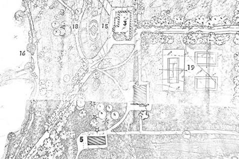
Figure 1. Sennitsa Manor. The General Plan Of The Estate. Fragment. *The number # 3 marks the main house; the number # 4 – the wing. Source: Archive of TSNRPM. Inv. No. 283/62. 1979 Among the cartographic materials prepared by the VNRC, one can also distinguish the profile of the territory/panorama of the park (1979)[9] and the map of the stages of construction of the Sennitsa estate (1980) [10]. The territory profile (see Appendix 1.6.) shows a complex area of terrain – the peak on which the main house is located. The map of the stages of construction clearly reflects on the territory plan the stages of development of the estate complex.
The lack of drawings of the main house of the Kellers complicated the process of 3D modeling, required the development of alternative methods of virtual reconstruction. In this context, it was important to find as many archival photographs of the main house as possible. 10 photos of the main house of the turn of the XIX-XX centuries were found, taken from different angles. The quality of the photographs is also strikingly different. A number of photos of the main house are placed in the act of the state historical and cultural examination of the Sennitsa estate from 2019, prepared by the Main Department of Cultural Heritage of the Moscow Region [2]. The origin of the originals of these photographs is indicated – they are in the personal collection of E. L. Minina. Two of the most successful photographs from this series were taken from a close distance, they clearly show the exterior decor of the building, the location of window and door openings (see Fig. 2.). Most likely, these pictures were taken at the turn of the XIX-XX centuries by the young Count A. F. Keller. He was fond of photography and often took pictures of family possessions in Sennitsy. 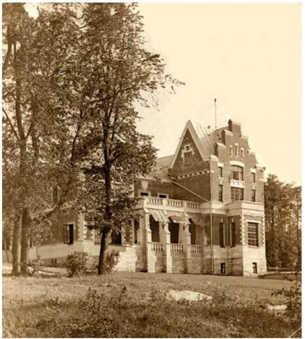
Fig. 2. The Keller manor house in Sennitsy. View from the north. Photo con. XIX – beginning . XX century. from the personal archive of E. L. Minina. Also, several photos of the main house were found in the funds of the Zaraisky Kremlin State Museum Reserve. They are publicly available on the website of the State Catalog of the Museum Fund of the Russian Federation [4]. Digital copies of archival photographs in high quality were obtained when visiting the museum. A photograph was found, which clearly shows the entire decor of the northern facade, as well as the entrance tower from the eastern facade. There are also three postcards in the funds of the Zaraisk Museum, in the corner of which there is an image of the main house of the Sennitsa estate from the eastern and western facades (see Fig. 3.). The quality of the images on the postcards is low, but they were also useful for creating a 3D model of the main house. 
Fig. 3. Photo of the Keller manor house in Sennitsy, placed on a postcard. Source: GMZ ZK. Inv. No. KP-17881 Several photos of the main house taken from the pond side are in the public domain. Also in the book written by A.G. Avchinnikov, a contemporary of Count F.E. Keller, in memory of him, a general of the Russian army, there is a very interesting sketch of the eastern facade of the main house [1, p. 48.]. The author of the pencil drawing is not known. This is a valuable source, as it shows the location of the windows on the eastern facade, which did not appear in any of the photos in its entirety. In the process of creating a 3D model of the main house, it was important to refer to some descriptions of the Keller mansion. The first subgroup of sources of this type is represented by inventories and estimates for construction; the second is narrative sources. In the inventory of the property of Countess M.A. Keller from 1895, the dimensions of the main house in fathoms are indicated [5, l. 22ob.Thus, it is possible to restore the dimensions of the house on the southern and eastern facades, the height of the house at the level of the second floor. An important document is kept in the archive of the RGVIA – "report on the construction of a stone house on the estate of Countess Keller at the village of Sennitsy in the Ryazan province of Zaraisk district", compiled by architect A.F. Kruger[7]. The report details the work on the construction of the house and indicates the monetary costs for them. So, it is possible to obtain the necessary data on the quadrature of the foundation and basement, to find out the number of window and door openings, stairs and stoves in the house. Another type of source is A.G. Avchinnikov's memoirs about Count Keller. The book ends with a passage about the arrival in 1904 of Fyodor Eduardovich's friends and colleagues at a memorial service in Sennitsy. Among the arrivals there is also A.G. Avchinnikov. On the pages of his book, he describes the Sennitsa estate – including the Keller mansion. The author points out that the house has two extensive terraces [1, p. 48.]. This conclusion of Avchinnikov confirms the hypothesis formed on the basis of the 1911 plan that on the side opposite to the front facade (i.e., on the southern facade), there was also a terrace with a view of the alley stretching into the distance. Virtual reconstruction of the main house of the Sennitsa estate late XIX – early XX centuries . At the first stage of our research [6], it was decided to make a reconstruction of the wing along with the reconstruction of the main house. This decision was dictated by several factors. Firstly, as already noted in the previous article [6], the wing was built in the same architectural forms as the main house, was distinguished by its large size, thereby not resembling typical outbuildings of noble manor complexes. From the point of view of the architectural solution, the wing is an interesting research object. Secondly, today the object of cultural heritage of federal significance "the wing of the Sennitsa estate" is in a ruined state; the restoration of this particular building seems to be the most important and paramount in the trend that has emerged in recent years towards the reconstruction of the entire estate complex. And, finally, thirdly, the creation of a 3D model of the wing at the first stage of virtual reconstruction directly contributed to the modeling of the main house with a claim to a high degree of reliability at the second stage of work.
The last indicated factor requires a detailed explanation of the path chosen by the author, along which the virtual reconstruction of the two most interesting objects on the territory of the Sennitsa estate, built at the turn of the XIX-XX centuries, was reproduced. Analysis of the sources showed that there were dimensional drawings of the wing in the location of the author of the work, in the case of the main house, there were no documents of this type. Sources on the Keller mansion were limited to photographs, a house plan, some descriptive characteristics, memoirs of contemporaries about this structure, materials of archaeological excavations of the foundation of the house conducted at the turn of the 1970s-1980s.. Of course, the presence of drawings allows you to achieve the most reliable result in the process of virtual reconstruction. In this case, the least amount of difficulties arises. Therefore, creating a 3D model of the wing caused many times fewer questions than creating a 3D model of the main house. At the same time, a clear understanding was formed that a reliable reconstruction of the Keller mansion is a real task, especially since the project to restore the appearance of the Sennitsa estate could not do without the reconstruction of the most important and interesting object that existed on the territory of the complex at the beginning of the XX century. It was very important to determine the stages of work on creating a virtual reconstruction of the main house, thereby approaching a reliable result. Having studied in detail the photographs of the main house, photographs and drawings of the wing, the author of the work concluded that the objects largely repeat each other (and not only stylistically). Definitely the same materials were used for the construction of buildings (red brick, white stone for the basement, facing material). This is evidenced not only by the comparative characteristics of the photographs, but also by the materials of the invoices for the buildings [7]. Also, the exact similarity of the corner rustication, cornices, pediments, forms of platbands, window frames, doors at the main house and the wing was established from the photographs. The buildings also had the same type of material from which the roof was made. Comparative characteristics of photographs would not be so effective without the use of artificial intelligence elements. We are talking about the colorization of black and white photos. On the MyHeritage website [14] there is an opportunity to process old photos, one of the tools of which is colorization. The transformed photos clarify the color scheme of the main house, which helps to compare it with the preserved wing building. After the analysis of the source base was completed, the first thing was a field study of the Sennitsa estate. There was an important task – to make measurements of rusticated stone. Knowing the dimensions of the rusticated stone, and I turn to the photos of the main house, it is possible to accurately restore the height of the building, as well as the dimensions of the window frames, which were also framed with typical rustication. The results of the field study showed that the rusticated stone is a faced masonry of three bricks in height, one and a half bricks in length and one brick in depth (240 mm in height, 410 mm in length, 70 mm in depth, taking into account the seam). The photos of the main house of the Sennitsa estate show that the first floor is framed with rustication, consisting of 15 objects, as well as the second floor. Accordingly, the height of the mansion from the first rustic block to the attic is 7200 mm, excluding the height of the interstory cornice. The same method was used to restore the dimensions of window frames in height; using the "MatchPhoto" tool in the SketchUp program, it was found that the highest point of most frames (especially those that have the largest dimensions and occupy a dominant position on the northern and western facades) is oriented parallel to a specific corner rusticated stone – in most cases, the 10th or the 11th from the beginning. At the same time, the lower point of the window frames is oriented relative to the position of the rusticated stone – as a rule, the lowest on the floor. Knowing the dimensions of the rustication also helped when working with dimensional drawings of the wing, which are equipped with a scale ruler, but more detailed values on them are rare. To confirm the hypothesis that the dimensions of the rusticated stone of the main house and the wing coincide, this element of the exterior decoration was measured on several surviving buildings on the estate – first of all, on the wing building and the power plant building. Also, when studying the photos of the main house in detail, it is noticeable that the rusticated stone is located on the scale of three bricks. Thus, the field study, within the framework of which about four hundred photographs were taken and measurements of certain details (first of all, rusticated stone) were made, became a preliminary stage of virtual reconstruction, which facilitated the subsequent process of lifting models of buildings of the main house and wing in height using the "Push/Pull" tool and the "Measurements" field in the SketchUp program. Then it was decided to start the virtual reconstruction with the modeling of the wing. This is explained by the fact that restoring an object according to drawings is a more understandable process than working with alternative sources. It was assumed that 3D modeling of the main house at the second stage of virtual reconstruction would be facilitated, taking into account the experience gained at the first stage of modeling an outbuilding built in the same architectural style and having the same elements of exterior decoration. In general, this assumption was justified, since after the virtual reconstruction of the wing according to the dimensional drawings, many objects poorly traced in the photographs of the main house became clear to the researcher. Also, according to the drawings, it was possible to determine in detail and further restore the design of various window frames and platbands of the wing. Then some of them were copied to a file in which the reconstruction of the main house was reproduced, and their sizes were increased/decreased using the "Scaling" tool. Thus, the choice of the way in which the first stage of the virtual reconstruction was associated with the modeling of the wing according to dimensional drawings, and the second with the modeling of the main house using alternative sources, was justified in this context. The process of 3D modeling of the wing was covered in detail in the previous article, so let's turn directly to the second stage of virtual reconstruction – 3D modeling of the main house of the Keller estate. The virtual reconstruction of the main house in the SketchUp program was started with the outline of the 1911 plan using the "Line" tool. Note that this plan, despite its schematics, shows in detail the construction of the foundation of the Keller mansion; however, there are no notes on the measurements of the foundation. Previously, this plan was combined with the materials of archaeological excavations of the foundation of the house, i.e. one bitmap image was superimposed on another. This was done in order to clarify the dimensions of the facades, projections and towers of the main house at their base. The photos lay on top of each other in a 3D editor, were transferred to a translucent mode and then combined to a ratio of 1:1. On the schematic plan of the excavation of the foundation of the house, the section of the rubble foundation, which was the central entrance tower to the house (from the western facade), is most clearly marked. The document specifies the dimensions of this section of the rubble foundation (4400 mm). Starting from them, the remaining sections of the foundation were restored by the method of ratios according to the plan of 1911. Then the "MatchPhoto" tool was used to reduce the measurement error. The outlined plan was temporarily extended thanks to the "Push/Pull" tool to an arbitrary height. Photos of the main house began to be combined with the resulting structure (see Fig. 4.). 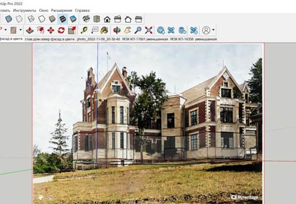
Fig. 4. Using the "MatchPhoto" tool to restore the dimensions of the main house in the base. Photo No. 1. Author's screenshot. When all the photos were oriented relative to the reference point, and the red and green lines were installed parallel to the facades of the building (see Fig. 5.), some changes were made to the design: certain areas were pressed in, others stretched out. The changes were insignificant, since the previous process of combining the schematic plan and the materials of archaeological excavations gave a fairly accurate result. After the first application of the "MatchPhoto" tool, the design was again returned to the original plan in two-dimensional space. To confirm the results obtained, it was important to refer to the inventory of the estate of Countess M. A. Keller from 1895, where the dimensions of the main house in fathoms are indicated. The dimensions of the house indicated in the inventory in length and width coincided with the dimensions of the plan created in the SketchUp program; the measurement error at the maximum points was 7-8 cm. Thus, at its foundation, the Keller mansion was restored with a high degree of reliability. 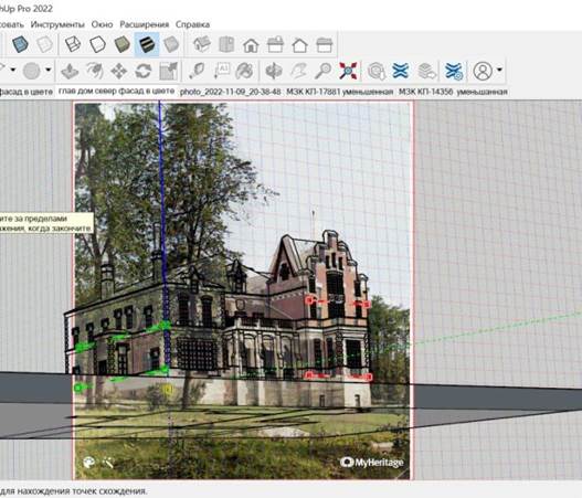
Figure 5. The process of combining a photo and a 3 D model in the SketchUp program using the "MatchPhoto" tool The height of the ground floor was determined thanks to the "MatchPhoto" tool. Also, the photos counted the number of white stones in the basement masonry in height. Based on the size of the white stone of the wing, a conclusion was made about the overall size of the basement of the main house. The structure was lifted up using the "Push/Pull" tool. At the same stage of work, the building was stretched to the level of the window frames of the first floor (see Fig. 6.). This section was already laid out of red brick, but lined with gray-white material on a similar principle with corner rustication. As in the case of the wing, at the very beginning of the virtual reconstruction, when creating the ground floor, it was necessary to make a landscape platform. The main house, as well as the outbuilding, was placed on a hilly area. The slope went to the pond in the direction from the southeast to the northwest, so the level of the ground floor of the southern facade was significantly lower than the level of the ground floor of the northern facade (450 mm versus 2190 mm, respectively). The degree of inclination was determined by a photograph of the main house taken from the western facade. According to the photographs of the main house, the entrance stairs from the east and west facades were recreated, as well as the platform for the front northern terrace. A photograph of the main house in excellent quality was found in the archive of the Zaraisk Kremlin State Museum-Reserve, which took an angle directly on the northern facade of the building. This photo was imported into SketchUp during the reconstruction of the ground floor and placed perpendicular to the ground plane. Thanks to the angle taken, this photo could be used to restore the dimensions of the main house – first of all, the dimensions of the ground floor, the entrance stairs from the north and east (without using the function ("MatchPhoto"). 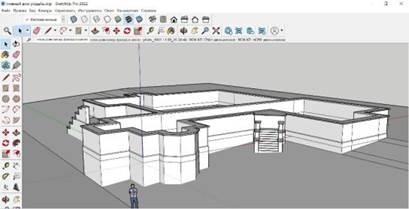
Fig. 6. The ground floor of the main house, located on a landscape platform. Author's screenshot After raising the building to the level of the window frames on the ground floor, further reconstruction of the mansion in height continued. As mentioned above, thanks to the knowledge of the dimensions of the corner rustication and the number of installed blocks, the dimensions of the first and second floors were accurately reproduced. Using the "Push/Pull" tool, after pressing the ctrl key, the building was consistently lifted up. First, with the help of the "Measurement" field, the walls were stretched by 3600 mm (15 rustication blocks of 240 mm each); then, following the example of the wing, the inter-storey cornice typical for the architectural style of the renovated Sennits was restored (480 mm in height); and finally, the building was again stretched by 3600 mm, thereby being reconstructed second floor. Further, the completion of some unique towers and projections from photographs was carried out individually. The eastern corner of the house represented the highest point of the building. Its final part was arranged on the cross principle of triangular and stepped pediments (see Fig. 7), referring to the elements of medieval towers and loopholes. This element is perfectly traced from different angles on each of the found photos of the main house. The triangular pediments on the projections of the western and southern facades were also restored; the completion of the symmetrical tower of the western facade, which has 5 sides, was decorated; finally, the entrance towers from the eastern and western facades were modeled, the first of which was made in one floor, and the second in two floors. The reconstruction of the main house in height was completed by creating a cornice and modeling decorative turrets that illuminated the attic. 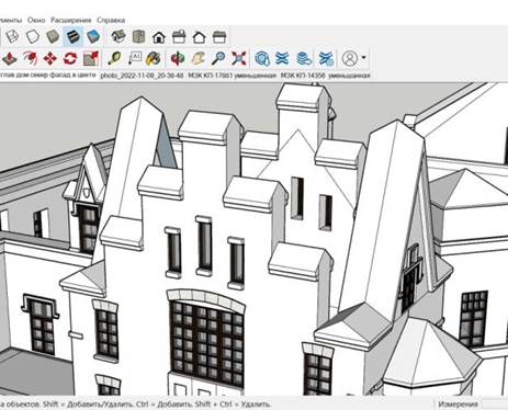
Fig. 7. The final part of the eastern corner of the main house, arranged on the cross principle of triangular and stepped pediments. Author's screenshot The most scrupulous work within the framework of virtual reconstruction is associated with the design of small forms and unique structures in the chosen architectural style. First of all, the front northern terrace was restored (see Fig. 8.). It was modeled separately, then transformed into a familiar "group" and then attached to the general structure of the main house. Initially, the components of standard columns and railings were created, then they were multiplied, placed on a plane and, finally, combined into a single "group" – the "northern terrace". Eventually, the terrace structure was attached to the previously prepared platform. 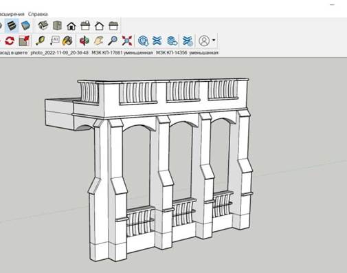
Fig. 8. Reconstruction of the terrace of the northern facade. Author's screenshot
Further, when relying on the photos of the main house, a corner rustication was placed, which framed not every corner. On the northern and western facades there were many complex transitions, the presence of rust on which would make the exterior decor excessive. It is also important to take into account the fact that the standard rust also framed some window frames. Then rectangular holes were squeezed out for the numerous Gothic windows located on the facades of the Keller mansion. As mentioned above, the dimensions of the window openings were set with reference to their location relative to the corner rust. The sizes of the small windows located on the second floor, gables and turrets were installed using the "MatchPhoto" tool. The author noted that most of the window frames of the main house and the wing were made in the same style, the location of the sashes and imposts coincided. For example, the design of the kitchen window on the eastern facade of the wing exactly coincided with the design of the windows on the ledge of the western facade of the main house; at the same time, the most common windows on the facades of the wing (in the size of 1 m x 1.5 m) coincided with most of the windows on the western and eastern facades of the main house; narrow elongated windows of the same type they were present both on the towers of the wing and on the towers of the main house. However, the sizes of the identical windows of the wing and the main house differed. In any case, there is no need to create new windows for the design of the main house. Typical windows from a file with a 3D model of the wing were copied by pressing ctrl+C and inserted into a file with a 3D model of the main house by pressing ctrl+V. Next, the dimensions of the existing window and the dimensions of the squeezed hole in the wall of the main house were measured. Then the ratio of the values by their length and width was calculated, and using the "Scaling" tool and the "Measurements" field, the window sizes decreased/increased according to the obtained coefficients (proportions). According to exactly the same principle, doors, standard platbands and arched decorative elements located above the windows of the wing were modified in order to use them on the facades of the main house. Thus, the time spent on the design of facades in the model of the Keller mansion was noticeably reduced. On the front facades of the main house, west and north, there were also some armorial distinctions of the Keller family. On the northern facade, facing the pond, the coat of arms of the Kellers was located on the second floor. Its forms were restored in the SketchUp program, then the figure was squeezed out and textured with a photo of the Kellers' coat of arms found on the website of the State Catalog of the Russian Federation in the collections of the Syzran Museum of Local Lore [3]. The result of the design of the facades of the main house is shown in Fig. 9. 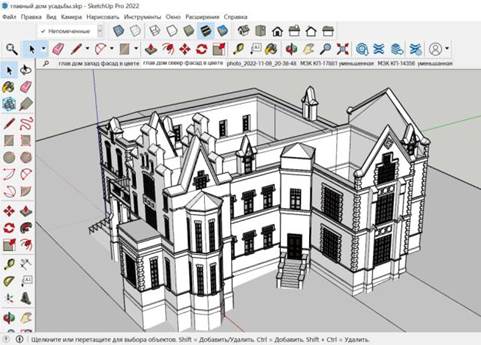
Fig. 9. The design of the facades of the main house in the SketchUp program. Author's screenshot It is worth mentioning some of the difficulties encountered in the process of decorating the facades of the main house. Unfortunately, not a single photograph of the southern (rear) facade of the Keller mansion, to which the lime alley led, has been preserved. Therefore, when restoring the back side of the house, it was impossible to claim a high degree of reliability. However, a certain trend was noticed in the composition formed by the main house and the wing – the most striking buildings on the territory of the Sennitsa estate. The northern facades of the buildings seemed solemn, they were facing the pond; also unique in their design were the western facade of the mansion and the eastern facade of the wing, on which the main entrances to the house were located – these sides of the buildings were facing each other and connected by a path. As for the eastern and southern facades of the main house, as well as the western and southern facades of the wing – they were like the outer sides of the house; they faced the forest; they were decorated with simplicity in comparison with the front facades of buildings; they had standard windows, architraves, decorative elements. This conclusion was made after analyzing photographs of the eastern facade of the main house, the western and southern facades of the wing and evaluating the office building after a field study. On this basis, in the absence of photographs of the back of the main house, it was assumed that the southern facade of the main house in its design should have repeated the typical decorative elements of other facades of the house. This was indirectly confirmed by the 1911 plan . On it, a rectangle marks the decorative design of the projection of the western facade (this decorative design consists of two white pilasters, between which the wall of the building is plastered with white, which can be seen in the photos). On the 1911 plan, there is also a designation in the form of the same rectangle on the ledge of the southern facade. Accordingly, it was assumed that pilasters and typical decorative decoration between them were present both on the western facade of the main house and on the southern one. In Avchinnikov's memoirs about the Keller mansion, it is mentioned that the manor house had two terraces that resembled each other [1, p. 48.]. The plan of 1911 just reflects that the terraces were located on parallel sides of the house (southern and northern facades), one with a view of the alley, with the other is on the pond. Accordingly, the 3D model of the terrace, restored for the design of the northern facade, was enlarged in accordance with the dimensions of the rear terrace on the 1911 plan and was installed on the southern facade. Thus, the southern facade of the main house was reconstructed on the basis of a typological comparison of the facades of the mansion and the wing, as well as the facades of the mansion with each other, therefore, the degree of reliability in the restoration of the rear side is less than in the case of the northern, eastern and western facades (see Fig. 10.). 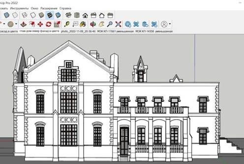
Fig. 10. Reconstruction of the southern facade of the main house based on a typological comparison in the SketchUp program. Author's screenshot
At the final stage of 3D modeling, it was important to restore the complex roof structure. Based on photographs taken from different angles and the 1911 plan, it was found that the main area of the building was covered with a hip roof. This type is distinguished by the presence of four ramps, despite the fact that the end ramps have a triangular shape, and the other two have a trapezoidal shape. This is probably the best solution for such a construction, since the hip roof is ideal for large-area houses, and its design withstands strong wind loads (the Keller mansion was just standing in an open space and on a hill). We add that the roof of the same geometric shape was chosen for the wing, to be more precise, for its western part. Despite the ruined state of the office building, this structure has survived to the present day. In turn, gable ceilings of small towers and projections of the western and southern facades, having a triangular pediment, adjoined the hip roof of the main house (see Fig. 11). The roof structure of the eastern corner of the house (the most elevated part) is also interesting, where triangular and stepped pediments were arranged perpendicular to each other. For this section of the building, the decision was wisely chosen to make a multi-gable roof, which is a perpendicular intersection of gable ceilings. Using the "MatchPhoto" tool, the height of the main hip roof and adjacent parts was restored. Then, using the "Line" tool and the "Dimension" field, the installed structure was created. When a set of lines closed into a two-dimensional figure (triangles and quadrilaterals), the program created a plane that protruded from the roof slopes. All the planes of the roof structure were combined into one "group"; the latter, in turn, was transformed into a "layer" for the convenience of hiding the object in order to texture the interior of the main house. 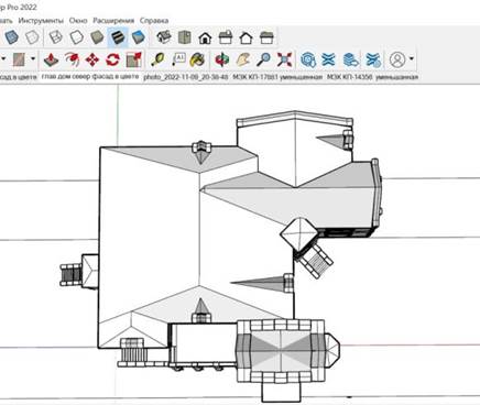
Fig. 11. The roof structure of the main house. Author's screenshot The last stage of 3D modeling was the creation of standard chimneys. When relying on the photos, it was found that there were three chimneys in the main house, two of which (brick) had a typical shape and were restored according to the drawings of the wing [13]. One of them, located in the eastern part of the house and had a steel frame, was restored from photographs of the main house and its sketch by an unknown author [1, p. 48.]. The work in the SketchUp program was completed by texturing a 3D model of the main house and a landscape platform. For this process, the same materials were used in the same proportions and with the same tools ("Texture – position" and "Fill") as for the outhouse (see Fig. 12-13.). It was extremely important to observe the proportions of the texture, since the main materials used were brick and white stone. If you do not observe the proportions of these materials when texturing a 3D model, the result will be unrealistic. It is more difficult and longer to work with such textures than when the building is plastered with one color. Once again, an important role in the texturing process was played by the possibilities of colorization of black-and-white photographs. 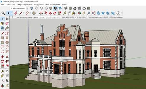
Fig. 12. The result of texturing the 3D model of the main house in the SketchUp program. View from the west. Author's screenshot 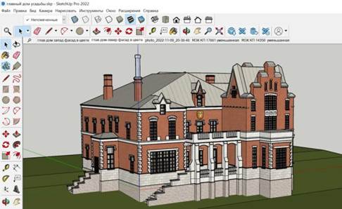
Fig. 13. The result of texturing the 3D model of the main house in the SketchUp program. View from the north. Author's screenshot The finished 3D model of the composition, including the main house of the Keller estate, an outbuilding and paths connecting them on a landscape platform, was imported into the Twinmotion program. This software is equipped with great opportunities to work with materials. On the NormalMap-Online website [15], a Normal Map was made for each of the "primary" textures that were superimposed on the surface of the models back in the SketchUp program. Further, in Twinmotion, the properties of each building material were separately improved: their relief, contrast, light reflection, shine were adjusted. This increased the realism of visualization. Twinmotion has a large library of objects and materials, as well as large resources for terrain customization. From the section "Vegetation and landscape" the landscape was based on the plain. Then, with the help of the "Sculpt terrain" tool, natural hills and lowlands were formed, and with the help of the "Paint terrain" tool, the material of trails and paths was revived. Then the "Paint grass" tool was used to create a grass cover. Early autumn (early September) was chosen as the season for the finished visualization. On the detailed Master plan of the estate in 1979 [9] trees and shrubs planted around the wing are indicated. Among them: lime trees, birches, oaks, elms, firs, pines, etc. The rich library of vegetation in Twinmotion made it possible to realistically recreate the landscape of the Sennitsa estate. It is worth noting the great potential of using neural networks to colorize photos of the early XX century. With the help of MyHeritage tools [14], the images of the main house of the wing were obtained in color, which helped both at the stage of texture selection in working with the SketchUp program and at the stage of improving their realism in the Twinmotion program. Fig. 14-23. presents the results of visualization of the main house and the outbuilding of the Sennitsa estate in the Twinmotion program (at different times of the day). The video material can be found on the author's Youtube channel at the link: URL: https://youtu.be/dYEJs4lwPMY (accessed 26.06.2023) 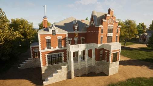
Fig. 14. Visualization of the main house of the Sennitsa estate in the Twinmotion program. The northern facade.
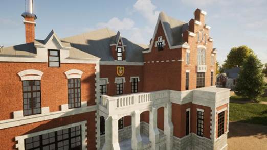
Fig. 15. Visualization of the main house of the Sennitsa estate in the Twinmotion program. The northern facade. 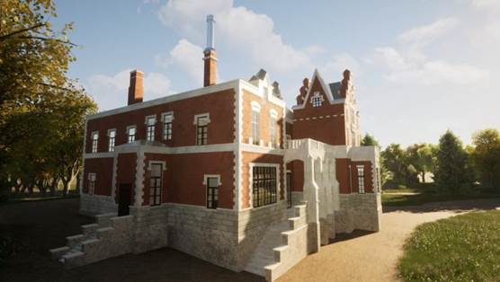
Fig. 16. Visualization of the main house of the Sennitsa estate in the Twinmotion program. View from the north. 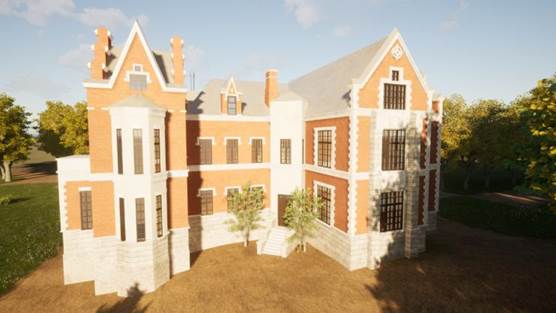
Fig. 17. Visualization of the main house of the Sennitsa estate in the Twinmotion program. The western facade. 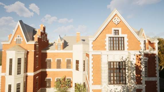
Fig. 18. Visualization of the main house of the Sennitsa estate in the Twinmotion program. The western facade. 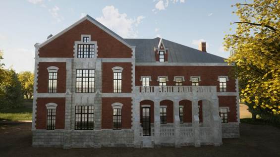
Fig. 19. Visualization of the main house of the Sennitsa estate in the Twinmotion program. The southern facade. 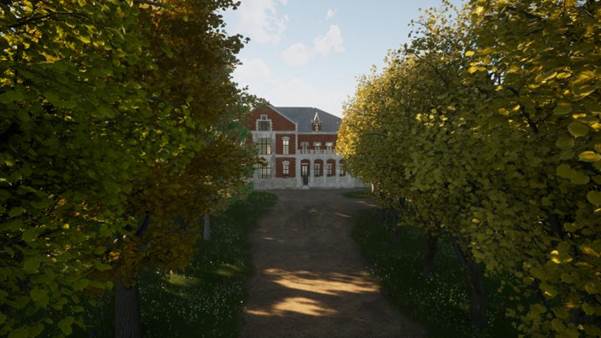
Fig. 20. Visualization of the main house of the Sennitsa estate in the Twinmotion program. View of the southern facade from the linden alley. 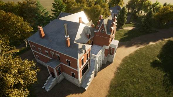
Fig. 21. Visualization of the main house of the Sennitsa estate in the Twinmotion program. Bird's-eye view from the north. 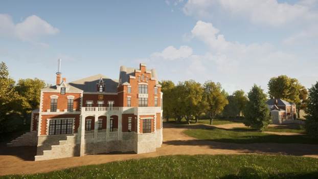
Fig. 22. Visualization of the composition of the main house and the outbuilding of the Sennitsa estate in the Twinmotion program. View from the northeast. 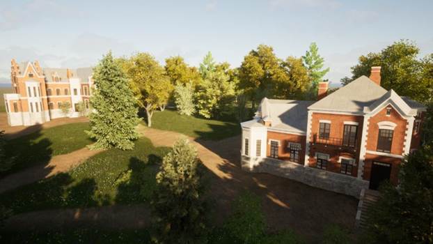
Fig. 23. Visualization of the composition of the main house and the outbuilding of the Sennitsa estate in the Twinmotion program. View of the east. *** Thus, on the basis of an extensive source base, a 3D model of the main house of the Kellers in the Sennitsa estate was created, as well as (for illustrative purposes) some of the elements of the surrounding landscape. The work on creating the geometry was carried out in the SketchUp program, and the rendering of the composition and the design of the landscape was carried out in the Twinmotion program. Also on the open 3D modeling platform, the SketchFab website [16], a model of the main house of the Kellers was posted with tags and annotations added to it. So, visualization is presented not only as a photo and video material, but also as a 3D model of public access, on which those who wish can view the Keller mansion from different angles. On the website, the finished model was placed in the section "Cultural Heritage & History"; it can be found by clicking on the link: URL: https://sketchfab.com/3d-models/9e20939751df4c649e89741f04dbc317 (accessed 26.06.2023) There is reason to hope that the virtual reconstruction created may be useful during the proposed restoration of the buildings of the Sennitsa estate The author of the work expresses gratitude for useful consultations and assistance in the work of senior lecturer of the Department of Historical Informatics Denis Igorevich Zherebyatyev, Director of the State Museum-Reserve "Zaraisky Kremlin" Kirill Vyacheslavovich Kondratiev, researcher of the State Museum-Reserve "Zaraisky Kremlin" Nikolai Viktorovich Nevsky, director of the museum "Kolomenskaya Pastila" Elena Nikolaevna Dmitrieva, researcher of the museum "Kolomna pastille" to Maxim Mikhailovich Muromsky, employee of the Central Scientific and Restoration Design Workshops of the Ministry of Culture of the Russian Federation Alexey Pavlovich Zaikin, local historian Sergey Mikhailovich Rogov.
References
1. Avchinnikov, A. G. (1906). In memory of Count F.E. Keller. Ekaterinoslav.
2. Act of the state historical and cultural expertise of the object of cultural heritage of federal significance 'Sennitsy estate, XVIII-XIX centuries', at the address: Moscow region, Ozery urban district, v. Sennitsy. (2019). Main Department of Cultural Heritage of Moscow Region (expert. Batalov A. L.) Moscow.
3. Coat of arms of the Keller family of counts. SCM. Inv. №. KP-6532_20.
4. State catalogue of the Museum Fund of the Russian Federation. Retrieved from https://goskatalog.ru/portal
5. The case of granting a loan to Maria Alexandrovna Fon Flot. GARO. Fund 150. Inventory 2. File 601. 1895-1915.
6. Korsakov, S. A. (2023). Virtual reconstruction of buildings of the Sennitsa estate near Moscow: sources and research methods. Historical computer science, 1, 55-78.
7. Reports, estimates and bills for buildings: churches, nurseries, chapels, etc. at the Sennitsky estate gr. Keller M. A. RGVIA. (1874-1904). Fund 189. F. E. Keller. Inventory 1. File 873. List 6-9.
8. The plan of the buildings of Countess Keller M. A. in the estate of "Sennitsy" of the Zaraisky district of the Ryazan province from February 10, 1911 of the Central State Administration of Moscow to 1917 Fund 311. Inventory 1. File 3614.
9. The estate of Sennitsy XVIII – beginning. XX century of the Ozersk district of the Moscow region. The master plan. The profile of the territory, the panorama of the park. Archive of CNRPM. Inv. №. 283/63. 1979
10. The estate of Sennitsa XVIII – beginning XX century of the Ozersk district of the Moscow region. (1980). Stages of construction of the estate. Historical and archival reference plan. Archive of CNRPM. Inv. №. 283/64.
11. Sennitsa Manor. The main house of the estate. Excavation of foundations. Archive of CNRPM. Inv. №. 283/96. 1981-1982.
12. Sennitsa Manor. Excavations of the manor house. (1979). Archive of CNRPM. Inv. №. 283/41.
13. Sennitsa Manor. The wing. Archive of CNRPM. Inv. №. 283/51-56.
14. MyHeritage. Retrieved from https://www.myheritage.com/?lang=RU
15. NormalMap-Online. Retrieved from https://cpetry.github.io/NormalMap-Online
16. SketchFab. Retrieved from https://sketchfab.com/feed
Peer Review
Peer reviewers' evaluations remain confidential and are not disclosed to the public. Only external reviews, authorized for publication by the article's author(s), are made public. Typically, these final reviews are conducted after the manuscript's revision. Adhering to our double-blind review policy, the reviewer's identity is kept confidential.
The list of publisher reviewers can be found here.
The reviewed article is devoted to the scientific virtual reconstruction of the main house of one of the estates of the Moscow region (Sennitsy). The article reflects the activity of historians of the Lomonosov Moscow State University on the preservation of historical and cultural heritage (estates near Moscow) by modern methods of applied computer science. The methodology of the article is traditionally used for this already established genre of scientific work. There are 2 main stages of reconstruction: the collection of sources and, in fact, the reconstruction itself. The article reflects both stages of this research work. It is the careful search for sources, their criticism, the identification of information potential and the conduct of other source-based procedures that distinguish scientific reconstruction from the usual one, ensuring maximum accuracy and reliability of the appearance of the reconstructed building (structure). The relevance of the research is determined primarily by the fact that virtual reconstructions are an important part of the work on preserving the Russian historical and cultural heritage, to a certain extent, in some cases, we can talk about its restoration in the form of virtual reconstructions. The scientific novelty of the presented materials is due to the introduction of new historical sources into scientific circulation and the proposed reconstruction of a new object, which is part of the architectural heritage of the Moscow region (manor). The article is written using the traditional structure of the presentation of the material for this genre. The introduction describes the context of this study, its statuization as part of a project to recreate the appearance of noble estates in the Moscow region, the object and subject of the study, the circumstances of the construction of the Sennitsa estate, information about the owners of the estate. The next section is devoted to the description and analysis of numerous sources for the virtual reconstruction of the main house of the estate: plans, maps, photographs. The latter turned out to be the most important source in this case due to the lack of drawings. Textual sources also took an important place in the reconstruction. The final section is devoted to the actual procedure and the results of the reconstruction. The article is very well illustrated with excellent quality materials that allow you to trace all the stages and results of virtual scientific reconstruction. The style and language of the article combine science and sufficient simplicity, which is important for expanding the circle of readers. It is worth noting separately that the article has a good logic for deploying the material. The bibliography of the article seems to be fully consistent with the genre and nature of the study, it contains mainly links to sources, as well as to the open SketchFab platform, where anyone can get acquainted with the results of the reconstruction. The article does not contain any discussion points and references to opponents due to its specificity and methodological orientation. It was not possible to find any significant flaws in the article. The work is devoted to a topic that continues to be relevant and popular, so it will certainly arouse great interest among readers. Because of this, the article is recommended for publication in the journal "Historical Informatics", the format of which it fully corresponds.
Link to this article
You can simply select and copy link from below text field.
|
|


