|
MAIN PAGE
> Back to contents
Arctic and Antarctica
Reference:
Pavlov B.A.
Map of the soil cover of the Olsky section of the Magadan Nature Reserve (Koni Peninsula)
// Arctic and Antarctica.
2024. № 1.
P. 62-97.
DOI: 10.7256/2453-8922.2024.1.70287 EDN: LLOYEK URL: https://en.nbpublish.com/library_read_article.php?id=70287
Map of the soil cover of the Olsky section of the Magadan Nature Reserve (Koni Peninsula)
Pavlov Boris Alekseevich
PhD in Biology
P RUS 75 9453607
111033, Russia, Moscow region, Moscow, Samokatnaya str., 1, building 2, office 21

|
borispavlo@yandex.ru
|
|
 |
|
DOI: 10.7256/2453-8922.2024.1.70287
EDN: LLOYEK
Received:
29-03-2024
Published:
10-04-2024
Abstract:
The object of the study was the unexplored soil cover of the Olsky section of the Magadan Nature Reserve. For this purpose, a route survey was conducted of 12 of the most characteristic tracts of the site available for hiking. The research methods generally accepted in Russian soil science were used. 11 soil subtypes were identified for the first time within the boundaries of the site, among which the most common are soils of the alphegumus and humus–accumulative departments, developing on granitoid derivatives overlain from above by an Aeolian cover of volcanic ash with a thickness of up to 0.25 m. A soil map has been compiled on which 9 contours of soil cover structures are outlined, among which the most widely represented combinations of ochreous podburs with sod-podburs illuvial-ferruginous ochreous, dry peat-ochreous podzols with ochreous podzols and dry peat-lithozems humus-peat, as well as ochreous gleevate podzols. 11 soil subtypes were identified for the first time within the boundaries of the site, among which the most common are soils of the alphegumus and humus–accumulative departments developing on granitoid derivatives overlain from above by an Aeolian cover of volcanic ash with a thickness of up to 0.25 m.A soil map has been compiled on which 9 contours of soil cover structures are outlined, among which the most widely represented combinations of ochreous podburs with sod-podburs illuvial-ferruginous ochreous, dry peat-ochreous podzols with ochreous podzols and dry peat-lithozems humus-peat, as well as ochreous gleevate podzols. The conclusion is made about the overwhelming influence of Kamchatka volcanism on soil formation and soil cover of the research area. The obtained results can be used for environmental purposes to replenish information about the environmental components of one of the poorly studied sites of specially protected natural territories of the North of the Far East, as well as in domestic soil science to clarify the genetic features of the influence of Kamchatka volcanism on the land cover of the vast oceanic region of the Pacific Ocean.
Keywords:
soil cover, ochreous subtypes of soils, ancient Kamchatka volcanism, Soil science, region, soil map, environment, natural areas, the structure of the soil cover, soil
This article is automatically translated.
You can find original text of the article here.
conduction Reliable information about the soils and soil cover of the Olsky section of the Magadan Nature Reserve was completely absent until this report and was of an assumed nature, due to its difficult accessibility, on the one hand, and good knowledge of the soil cover of the Primagadan sector of the northern coast of the Sea of Okhotsk [2]; [10]; [11]; [12]; [13]; [16]; [18]; [19]; [20]; [21]; [22]; [23]; [24]; [25]; [26]; [29]; [36]. In this regard, four soil contours are indicated on the soil map of the Magadan region within the boundaries of this site: illuvial-multi-humus dry-peat dry-frozen podzols, tundra podzols (without separation), illuvial-humus and ferruginous-humus podzols without separation dry-frozen, primitive gravelly [33]. The presence of ash material in the listed soils is not marked on the map. METHODS Modern Russian teachings on the diagnosis and classification of soils, as well as on their structural and spatial organization, are used as a methodological basis for the diagnosis and nomenclature of soils, as well as for mapping the soil cover of the Olsky reserve "Magadan"[35]; [37]; [38]. The cartographic modeling is based on a publicly available topographic map of the Kony Peninsula at a scale of 1:100,000, as well as field and desk materials of morphological descriptions of relief and microrelief, plant communities and their species composition, the structural organization of the contours of the soil cover and individual genetic profiles of soil subtypes. The objects (units) of mapping were homogeneous contours of landscape areas, plant communities and soil subtypes forming soil mesocombinations — structures of soil cover (SPP). The latter are indicated on the map by formulas consisting of conventional letter designations of soil subtypes connected by mathematical symbols in sequential descending order of occupied. It is assumed that the first component in the SPP formula occupies approximately 60-70% of the area of the SPP contour. The following components are 20 and 10%, which allows for the final calculation of the areas occupied by soil subtypes within the boundaries of the mapping site. SOIL FORMATION FACTORS Geology, topography and soil-forming rocks The Olsky section of the Magadan Nature Reserve is located within the boundaries of the mountain uplift of the Koni Koni peninsula of the Taigonossky mountain system [3]. This massif is made mainly of mid-mountain denudation-tectonic Mesozoic folds (60%) and separate, Early Cretaceous intrusions (40%). The Mesozoic folds of the peninsula comprise the Lower and Middle Jurassic terrigenous fine-grained siltstones, gravelites, sandstones and mudstones tuffs of andesites and dacites [6]; [7]. Intrusive formations compose the northern and southern macrosclines of the peninsula, as well as locally bulge out of the Mesozoic folds in the form of separate rocky outcrops. They are represented by strong, highly resistant to weathering Lower Cretaceous intrusions of granodiorites, diorites and quartz monzonites, including tuffs of andesites, sandstones and conglomerates of the Aptian tier. Along the entire watershed axis of the peninsula, snowfields are expressed in nival hollows and ancient glacial karas and throgs with glaciers, end-moraine shafts of coarse—grained material, short water - glacial zanders with small glacial lakes, stormy sources of mountain rivers and waterfalls. The listed geomorphological forms give an alpine—type appearance to the entire high—altitude tier of the peninsula, especially its axial mountain range with maximum absolute marks up to 1550 m (Ugryumaya — 13161.1 m, Rocky - 1549.7 m, etc.). The angles of the natural slopes of the mountain structures of the peninsula are 32-35 o, the total depth of the erosion network is 440-500 m. The latter has a density of 0.6, a total length of 619 km, an average tortuosity of 1.2, and is formed by 5 rivers of 2-3 orders (according to R.E. Horton [39]), as well as 12 mountain streams of 1-2 orders, These watercourses are characterized mainly by snow feeding from high—altitude snowfields and small glacial lakes, exuberant mountainous character, narrow V-shaped valleys with waterfalls, the absence of alluvial terraces, the presence of narrow riverine floodplains. The lake content coefficient of the entire territory of the Olsky site barely reaches 0.001. The soil-forming rocks on the peninsula are mainly a soil-pyroclastic surface layer of fine-sanded volcanic ash of rhyolite composition with a thickness of up to 0.15 m and the underlying products of modern weathering of parent massive crystalline rocks: eluvium, colluvium, proluvium, deluvium with a thickness of 2-3 to 10-15 m. The first layer lies in a cloak-like manner under organogenic soil horizons, and is also present in the form of bulk accumulations and impurities in the underlying loose strata [5]; [17]; [32]. Due to gravity, these strata slide down the slopes at different speeds, depending on the terrain slopes, fluctuations in the hydrothermal regime, a variety of pertographic and granulometric composition, forming various forms of microrelief. Thus, on steep mountain and marine coastal cliffs, under the influence of physical weathering and gravity, talus and mudflow proluvial-colluvial cones of loose coarse-grained material with a size of 1.0 m are formed everywhere, depending on the height of the cliffs. On more gentle mountain slopes, delayed creep and solifluction of eluvial-deluvial rocky-fine-grained masses occur with the formation of gentle ridges, mounds and terraces with dimensions from 0.5-1.0 to 10 meters or more, accumulating in the lower parts of the slopes into deluvial plumes up to several hundred meters long and up to 10-15 m thick. In turn, simultaneously with creep and solifluction, the surfaces of the plumes are subjected to planar and linear erosion with the formation of trickle forms of microrelief in the form of branched, winding and straightened runoff hollows (valleys) up to 5-10 m wide, 1-2 m deep and up to several hundred meters long. It should be particularly noted that volcanic ash particles are not observed at all or, nevertheless, are present in small quantities on the surface and active strata of actively mobile, uncovered by forest vegetation, highly borehole eluvium, colluvium and alluvium, as a result of flushing by precipitation and alluviation into the underlying horizons. At the same time, they are actively involved in the streams of seasonal flooding, forming rare focal clusters in soil voids and cracks, as well as on the daytime surface, in places where they are wedged to the surface in the form of springs.
In addition to these, alluvial deposits of boulder-pebble composition with an admixture of gravel and sand with a thickness of up to 5-10 m in the form of riverbed, floodplain and delta facies with a width of up to 100 m accumulate in the lower reaches of local watercourses. Along with the latter, within the boundaries of an almost continuous steep coastal strip framing the peninsula from all sides, coastal-marine sediments accumulate in the form of surf spit and beaches of pebble–boulder composition with an admixture of gravel and sand up to 100 m wide and up to 10 m thick. In the coastal strips of shallow estuaries of the local rivers Khindya, Burgali, Antara, Komar, Crab, tidal beaches with a width of up to 200 m of pebble-sand composition with layers of gravel, silt and detached seawater with a total capacity of up to 5 m are formed. The listed surface transformations of parent rocks into soil-forming ones significantly transform their original physical and chemical-mineral composition. In this regard, the polygenetic generation of fine-grained stony loose soil-forming rocks, characterized mainly by acidic and medium-acid silicate composition, is widespread on the peninsula. At the same time, the ubiquity of Aeolian deposits of volcanic ash of acidic (rheolitic) composition plays an essential role in increasing their acidity and fine-grained content, as noted above. Permafrost within the boundaries of the Olsky section of the Magadan Nature Reserve is found in local areas of steep indigenous slopes of the northern exposure of the primorsky strip of the Koni mountain range under dense green-mossy-sphagnum cedar elfin and powerful peat horizons, approximately at a depth of up to 0.5 from the daytime surface in the form of strongly layered lenses of colluvial—proluvial deposits, as well as on subhorizontal surfaces of nival terraces and glacial carts occupied by Alpine meadows at a depth of 0.5 to 1.0 m from the daytime surface, in the form of lenses of frozen, water-resistant gravelly-fine-grained proluvial-deluvial deposits. These facts correspond to the scheme of S.A. Zamolotchikov (1989), according to which permafrost rocks on the Priokhotomorskaya land form an island zone, their intermittent distribution with temperatures from minus 1 to minus 11 ° C with a thickness from 100 to 700 m [8]. This zone on the northern side of the Kony Peninsula probably has an approximate width of 10 km from the edge of the sea waters. On the southern side, its width is significantly reduced under the influence of the exposure effect, approximately up to 3-5 km [9]. Due to harsh climatic conditions, permafrost is ubiquitously present in "dry form" within the boundaries of the axial alpine-type mountain range of the Koni Peninsula, approximately at a depth of 1.0 m from the daytime surface. Climate In accordance with the regional climatic zoning, the territory of the Olsky section of the Magadan Nature Reserve is located in the tundra and forest tundra climate zone within the forest with great severity of weather, which is generally characterized by excessive moisture, cold summers, frosty snowy winters with an average January temperature above minus 32 ° C [14]. According to long-term data from the nearest weather stations (HMS Magadan and HMS O. Zavyalova) The following meteorological parameters are typical for the Kony Peninsula: the average annual air temperature from minus 2.9 to minus 3.5 °C; average annual wind speed from 5.0 to 6.3 m/s; average annual relative humidity from 72 to 80%, average annual precipitation from 526 to 647 mm; snow cover height from 12 to 32 cm [27]. At the same time, attention is drawn to the general increase in the climate severity index (Budman) in island conditions (HMS O. Zavyalov) relative to coastal ones (HMS Magadan) from 2.7 to 3.8 points due to increased wind speeds. It is easy to assume that an equally high severity score of climatic conditions is typical for the Kony Peninsula, especially for its axial alpine watershed. This is also evidenced by the complete absence of larch within the boundaries of the site and the absolute dominance of dense thickets of cedar elfin, which escapes during the cold period of increased severity under the snow and thus forms a high-altitude belt of specialized taiga vegetation [1]; [15]; [28]. Landscape organization The territory of the Olsky section of the Magadan Nature Reserve is located in the conditions of a subzone of coastal terraced-hilly and hilly-rocky tundra forests of the kochkarnik of the Magadan province of the primorsky tundra forests [30]. Within its borders, the vast area (66%) is occupied by the landscape district of mountainous and mountain-valley tundra forests (cedar plantain), located within the average altitude level (from 300-800 m above sea level) (see Fig. 1). Its external aspect is represented by dense thickets of cedar plantain. A significant share of the site (23%) falls on the landscape district of mountain deserts and tundra, which has a bright alpine type appearance and is located in the range of absolute heights from 800 to 1550 m. A significantly smaller proportion of the site (9%) belongs to the landscape district of upland-terraced-hilly tundra forests, sporadically occurring in the form of rounded and oval spots in the range of absolute heights from 300 to 600 m and represented by various tracts of swampy hummocks (tundra), alpine meadows, stone-cuttings and areas of grass self-cultivation of forest harems. Even less significant, but equivalent shares (3% each) of the territory of the Olsky site belong to the landscape areas of valley-river tundra forests and forests, marching and abrasive coastal tundra forests, meadows, beaches, scree and cliffs. The former are mainly represented by pebble–boulder beaches, forest, willow and meadow floodplain tracts of river valley bottoms. The latter are marine pebble—boulder terraces and sandy-pebble beaches, scree and rocky cliffs without vegetation. Vegetation
Geobotanically, the Olsky section of the Magadan Nature Reserve is part of the mountainous region of cedar elfin and larch-birch forests of the Okhotsk coast [34]. 6 plant communities were previously identified within its boundaries: epilitic-lichen mountain deserts; moss-lichen sedge-fluffy tundra; sedge-fluffy cedar planches; shrubby cedar planches; moss cedar planches; groves of stone birch; sedge-fluffy cedar planches; grass-mixed willow thickets; shrubby grass poplar-chozen forests vegetation complexes at different stages of post-fire restoration successions [4]. The conducted studies of the soil cover make it possible to significantly expand this list to the following 16 communities, to clarify their dominant floral composition and nomenclature: epilitic-lichen rocky mountain deserts (8%); rocky-lichen mountain tundra with prostrate cedar planches (3%); rocky-shrub (dryad) mountain tundra with prostrate cedar planches (2 %); rocky-shrubby (arkous) mountain tundra with prostrate cedar planches (2 %); groves of stone birch (3%); cedar planches shrubby-dead-covered (15 %); cedar planches grass shrubby-moss on old burning (10 %); cedar planches shrubby-moss (25 %); cedar elderberry-green-mossy-sphagnum (13%); nival willow-grass meadows (3%); calcareous sedge-fluff tundra (1%); pyrogenic ivanchaevo-veiny synusia (2%); shrubby grass poplar-chozen forests (1%); grass-grass willow (0, 5 %); alder grasses; variegated grasslands (1 %). The most common among them are communities of cedar elfin trees, which occupy 63% of the territory of the Olsky site. The distribution of the remaining communities is fragmentary, mainly due to local peculiarities of the genesis of alpine-type and erosive forms of microrelief, the presence of exposure effects and rare forest fires. Cedar clumps of shrubby dead-cover are confined to the upper parts of gentle slopes and smoothed bends of watersheds, composed of colluvial-deluvial gravelly-gravelly deposits with a low-power cover of fine-sanded volcanic ash. The vegetation is absolutely dominated by Pinus pumila (Pall.) with separate curtains Ledum decumbens (Ait.) Lodd. ex Steud., Vaccinium uliginosum L., Vaccinium vitis-idaea L. (Fig. 1) 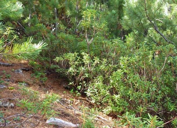
Fig. 1. Cedar elfin shrub-dead-cover in the upper part of the gentle slope near Cape Flat Cedar elfin grassy shrub-moss along the old burns are formed in the form of steep wavy stripes and fistulate spots in geomorphological conditions similar to the community described above, and as a result of the passage of a long-standing weak grass-roots fire through it, which partially destroyed the coniferous forest floor. Their main distinguishing feature is the active participation in the composition of the herbal post-fire community of such sodominants as: Calamagrostis langsdorffii (Link) Trin) and Chamaenerion angustifolium (L.), as well as Polytrichum commune Hedw in the vicinity of Sorbus sambuecifolia bushes (Cham. Et Schlecht.) M. Roem and Spiraea beauverdiana Schneider. Cedar elfin shrub-moss are mature communities formed on the gentle slopes of the basement terraces, overlain by deluvial plumes with a thin surface cover of volcanic ash, as part of the absolute dominant — Pinus pumila (Pall.) Regel. featuring: Ledum decumbens (Ait.) Lodd. ex Steud., Betula middendorfii Trautv.et C.A.Mey, Vaccinium uliginosum (L.), Rhododendron aureum Georgi), Salix fuscescens Anderss. and admixture: Empetrum nigrum L., Rubus chamaemorus (L.), Spiraea beauverdiana Schneider, as well as very rare herbs: Calamagrostis langsdorffii (Link) Trin; Carex soczavaeana Gorodk.; Aconogonon tripterocarpum (A.Gray) Hara; Chamaenerion angustifolium (L.) Scop.; Hamaepericlymenum suecicum ( L.) Aschers. et Graebn; Chamaenerion angustifolium (L.) Scop with admixture: Equisetum sylvaticum L.; Aconogonon tripterocarpum (A.Gray) Hara; Artemisia arcticf Less. The ground cover is dominated by Polytrichum commune Hedw. with an admixture of Sphagnum spp. L. and Cetraria nivalis (L.) Ach. (Fig. 2). 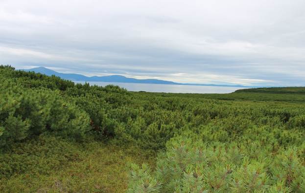
Fig. 2. Cedar dwarf shrub-moss on a gentle slope to Cape Plosky (photo by N. Sazanova) Cedar elms of green-mossy-sphagnum occupy the steepest (32-35 o) indigenous mountain slopes and slopes of upland terraces of northern exposures, composed of colluvial-deluvial deposits without signs of the presence of volcanic ash, usually frozen at a shallow depth from the daytime surface (up to 0.5 m). These plant communities are climactic (Fig. 3). 
Fig. 3. Cedar elfin moss-sphagnum on a steep section of the mountain slope to the cape Flat Their stands are still dominated by Pinus pumila (Pall.). The ground shrub-moss covers are mainly represented by: Sphagnum spp. L. with an admixture of: Aulacomnium palustre (Hedw.) Schwaegr.; Dicranum scoparium Hedw; Nardia scalaris (S with lirad.) S. F. Gr au.; T hamnolia vermicularis Sw.; Peltigera aphthosa (L.) Willd S with haer.; Cetraria nivalis (L.) Ach.; and also: Ledum palustre L.; Betula exilis Suckczev; Vaccinium vitis–idaea L.; and rare: Rubus chamaevorus L.; Arctostaphylos aipina (L.) Spreng; E quisetum sylvaticum L., etc.
Epilitic-lichen rocky mountain deserts occupy the highest relief positions. In the contours of the latter, the density of lichen covers reaches approximately 30%. Their composition is dominated by: Rhizocarpon geographicum (L.), DC.; Gasparrinia elegans (Link.) Stein; Licidea sorediza Nyl.; Parmelia saxatilis (L.) Ach.; the impurities include: Haematomma ventosum (L) Massal.; Pertusaria amara (Ach.) Nyl.; Gyrophora proboscidea (L.) Ach. and Gyrophora arctica Ach.; Cetraria cucullata (Bellardi) Ach.; Cladonia rangiferina (L.) Web.; Stereocaulon paschale (L.) Hoffm.; Usnea longissima Ach.; Thamnolia vermicularis (L.) Ach., etc. Rocky-lichen mountain tundras with prostrate cedar elanics are generally located several meters below epilitic-lichen rocky mountain deserts, as a rule on leveled mountain microplats and in saddles with protruding intrusive kekurs, with fragmentary covers of volcanic ash thinned to 3-5 cm (Fig. 4). Projective covering of curtains of lichens, shrubs and The number of cedar elfin bushes pressed to the ground is about 50%. The composition of their vegetation cover is dominated by: Thamnolia vermicularis (Sw.); Peltigera aphthosa (L.) Willd S with haer.; Cetraria nivalis (L.) Ach.; Stereocaulon paschale (L.) Hoffm.; With etraria cucullata (Bellardi) Ach.; Cetraria nivalas (L.) Ach.; Cetraria islandica (L.) Ach.; Cladonia alpestris (L.) Rabh.; Cladonia rangiferina (L.) Web.; Peltigera aphthosa (L.) Willd.; Hylacomium splendens (Hedw.) B.S.G.; Dicranum elongatum Schleich. and others . Pinus pumila (Pall.) is dominated by: Ledum decumbens (Ait.) Lodd. ex Steud.; Vaccinium uliginosum L.; Vaccinium vitis–idaea L.; with the participation of: Thymus serpyllum L.; Juniperus communis L. 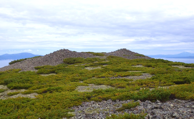
Fig. 4. Rocky-lichen mountain tundra with prostrate cedar elfin in the upper part of the hill 909. 2 m. 5 km south-southwest of Cape Plosky. Rocky-shrubby (dryad) mountain tundras with prostrate cedar elanics also occupy well-blown, flattened surfaces of upland terraces with kurumniks partially filled with proluvial-deluvial deposits and fragmentally covered with thinned volcanic ash covers. Dryas ajanennensis Juz absolutely dominates them in open rocky areas. subsp ochotensis Jurtz., there are Salix arcticf Pall jackets. with an admixture of Salix sphenofylla A. Skvorts and inclusions: Hedysarum hedysaroidex (L.) Schinz et Thell.; Rododendron lapponicum (L.) Wahlenb. (Fig. 5). In the lichen jackets between the stones, the following grow mainly: Cetraria cucullata (Bellardi) Ach.; Cetraria nivalas (L.) Ach.; Cetraria islandica (L.) Ach.; Cladonia alpestris (L.) Rabh.; Cladonia rangiferina L. interspersed with: Stereocaulon paschale (L.) (Hoffm.) Web.; T. hamnolia vermicularis (Sw.); Peltigera aphthosa (L.) Willd S with haer. and others . (Fig. 5). The composition of vegetation under the crowns of prostrate cedar bushes is similar to that described in the previous paragraph. 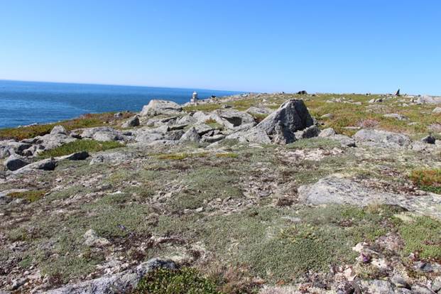
Fig. 5. Rocky-shrubby (dryad) mountain tundra with prostrate cedar elfin on Cape Alevina (photo by N. Sazanova) Rocky-shrubby (Arctous) mountain tundras with outstretched cedar elms are formed in proximity to the "dryad mountain tundras". Their composition is absolutely dominated by Arctous alpine L. with the obligatory presence of extensive curtains of Salix magadansis Nedoluzko with an admixture of Salix fuscencens Anderss. and sealed curtains: Hierochloe alpine (Sw.ex Willd.) Reem Schinz. Schult.; Artemisia arctica Less.; Valeriana capitate Pall. Ex Link; Oxiria diguna (L.) Hill; Loiseleuria procumbens (L.) Desv. with the presence of lichen mounds on rocky areas and on stones from: With etraria cucullata (Bellardi) Ach.; Cetraria nivalas (L.) Ach.; Cetraria islandica (L.) Ach.; Cladonia alpestris (L.) Rabh.; Cladonia rangiferina L. interspersed with: Stereocaulon paschale (L.) (Hoffm.) Web.; T. hamnolia vermicularis (Sw.); Peltigera aphthosa (L.) Willd S with haer.; Rhizocarpon geographicum (L.), DC.; Licidea sorediza Nyl.; Parmelia saxatilis (L.) Ach.; Usnea longissima Ach. and others . (Fig. 6). Under the outstretched bushes of cedar elfin, the vegetation is similar to the one described above. 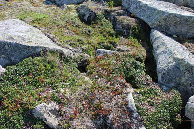
Fig. 6. Rocky–shrubby (Arctous) mountain tundra with prostrate cedar elfin on Cape Rocky (photo by N. Sazanova) Groves of stone birch are found among cedar planches on steep transit parts of slopes, usually southern exposures, composed of colluvial-deluvial rocky gravelly-gravelly deposits with low-power covers of fine-sanded volcanic ash. Their species composition is not rich, represented by the dominant Betula lanata (Regel) V. Vassil. admixture of spreading bushes: Pinus pumila (Pall.); Sorbus sambuecifolia (Cham. Et Schlecht.); Duschekia fruticosa (Rupr.) Pouzar; Ribes dikuscha Fisch. ex Turcz. Under their canopy, in a sparse grass layer, there are: Calamagrostis langsdorfii (Link) Trin.; Maianthemum bifolium (L.) F. W. Schmidt; Dyopteris fragrans (L.) Schott) and Polytrichum commune Hedw. (fig. 7). 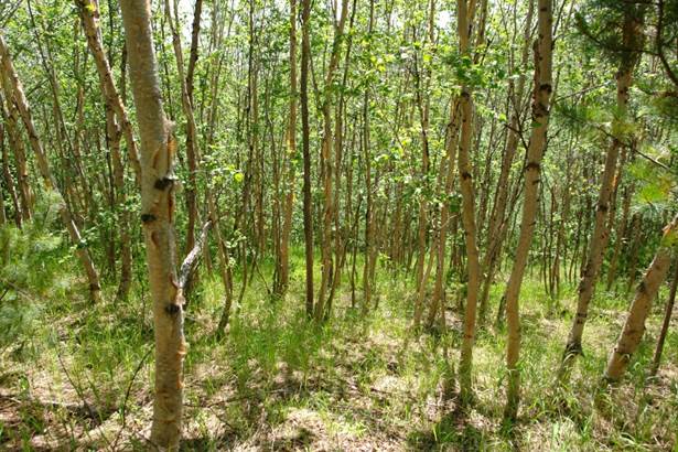
Fig. 7. Veynikovo-dead-cover stone birch grove on the steep slope of glacial kara on the left bank of the Khindzha River, 4.2 km southwest of Cape Plosky (photo by N. Sazanova)
Nival willow-grass meadows confined to the subhorizontal surfaces of cryoplanation terraces and niches, bottoms of troughs and circuses filled with layered colluvial-deluvial loams with sandy-gravelly and gravelly inclusions, as well as an abundant admixture of fine particles of volcanic ash. Their composition is dominated by: Calamagrostis langsdorffii (Link) Trin; Comarum palustre L.; Chamaepericlymenum suecicum (L.) Aschers. et Graebn.; Carex soczavaeana Gorodk.; Valeriana capitate Pall.Ex Link.; Veratrum oxysepalum Turcz.; Claytonia sarmentosa C. A. Mey.; present: Aconitum ajanense Steinb; Aconitum lycoctonum L.; Aconogonon tripterocarpum (A.Gray) Hara; Geranium erianthum DC; Anemone debilis Fisch. ex Turcz.; Anemone dichotoma L.; Ranunculus pygmaeus Wahlenb. ; Iris setosa Pall. ex (Link); Plemonium cferuleum L.; Bistorta elliptica (Willd. ex Spreng.) Kom.; Chamaepericlymenum suecicum (L.) Aschers. et Graebn.; Solitago virqaurea L.; Gentiana glauca Pall.; Phyllodoce caerulea (L.) Bab.; with admixture: Maianthemum bifolium (L.) F.W. Schmidt; Maianthemum dilatatum (Wood) Nels. et Macbr; Iris setosa Pall. ex Link; Claytonia sarmentosa C. A. Mey; Anemone dichotoma (L.); Aruncus dioicus (Walter) Fernald; Sphagnum spp. L.; Polytrichum commune Hedw; and seedlings: Pinus pumila (Pall.); Rhododendron aureum Georgi; Salix sphenophylla A. Skvorts; Salix magadanensis Nedoluzhko; Rhododendron camtschaticum Pall.; Spiraea beauverdiana Schneider.; Potentilla fragiformis Willd. ex Schlecht., with a small distribution on Polytrichum commune Hedw. and Racomitrium canescens (Hedw.) Brid drainages (Fig. 8). 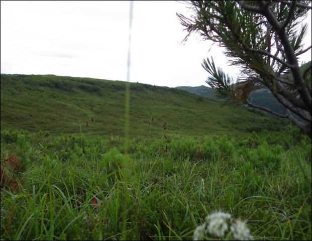
Fig. 8. A nival willow-grass meadow in the upper reaches of the stream. Lonely, 4 km south of Cape Rocky Pyrogenic Ivanchaevo-Veynikov successions develop on the site of burnt-out communities of cedar elfin trees. In their composition, monodominant loose curtains Calamagrostis langsdorffii (Link) Trin and Chamaenerion angustifolium (L.) with an admixture of: Senecio pseudoarnica Less.; Tussilago frigida L.; Marchantia pjlimorpha L. develop within a few years after the fire, among burnt fractures from dry branches of cedar elfin, pyrogenic kurumnik.; as well as renewable Shoots: Betula exilis Suckczev; Pinus pumila (Pall.); Ledum decumbens (Ait.) Lodd. ex Steud.; Salix glauca L.; Duschekia fruticosa (Rupr.) Pouzar (Fig. 9). 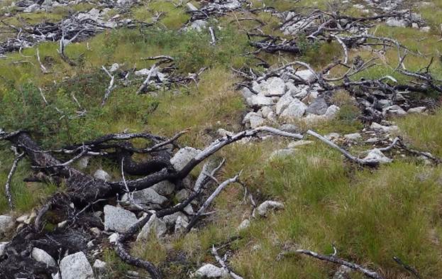
Fig. 9. Pyrogenic Ivanchaevo-veynikov succession in a burnt-out area of cedar-planar thicket on the flat watershed between the streams Variable and Shrubby The sedimentary sediment-fluff tundras are confined to gently sloping poorly drained accumulative surfaces of deluvial plumes and upland terraces composed of gravelly-loamy proluvial-deluvial deposits with diffuse inclusions and thin layers of accumulations of volcanic ash particles. These plant communities are mainly represented by the following dominants: Eriophorum vaginatum L.; Carex globularis L.; Carex pallida C.F. Mey; Carex soczavaeana Gorodk; Eriophorum scheuchzeri Hoppe; Polytrichum commune Hedw.; Sphagnum spp. L.; Cetraria nivalis (L.) Ach. with a rare admixture of oppressed prostrate biomorphs Pinus pumila (Pall.) Regel., rare bushes and curtains Ledum decumbens (Ait.) Lodd. ex Steud.; Betula exilis Suckczev; Salix fuscescens Anderss.; Vaccinium uliginosum L.; Empetrum nigrum L.; Rubus chamaemorus L. and solid moss covers from solid curtains: Aulacomnium palustre (Hedw.) Schwaegr.; Dicranum elongatum Schleich.; Drepanocladus uncinatus (Hedw.) Warnst; Hylacomium splendens (Hedw.) B.S.G.; Polytrichum commune Hedw.; Sphagnum sp. L. (fig. 10). 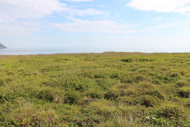
Fig. 10. Sedge-furred tundra on the high terrace of the Burgali river (photo by N. Sazanova) Shrubby grass poplar-chozen forests are formed on old-growth sites of the local largest watercourses and represent the most productive climax plant communities consisting of the following dominants: Populus suaveolens Fisch; Chozenia arbutifolia (Pall.) A. Skvorts; Salix udensis Trautv. et C. A. Mey.; Salix schwerinii E.Wolf; Salix krylovii E.Wolf; Salix pseudopentandra (B. Floder.), with rare participation: Salix magadansis Nedoluzhko, Duschekia fruticosa (Rupr.) Pouzar.; Spiraea beauverdiana Schneider; Betula platyphylla Sukacz.; Pinus pumila L.; Rubus idaeus L.; Sorbaria sorbifolia L.; Ribes dikuscha Fisch. ex Turcz.; Ribes triste Pall; Rosa acicularis Lindl.; Lonicera caerulea L.; Vaccinium vitis-idaea L.; Vaccinium uliginosum L.; sparse grass cover from: Calamagrostis langsdorffii (Link) Trin.; Arctagrostis arundinacea (Trin.) Bead.; Calamagrostis lapponica (Wahl) C. Hartm.; with participation: Polygonum tripterocarpum A. Gray; Chamaerion latifolium (L.) Holub; Iris setosa Pallas ex Link.; Artemisia borealis Pall.; Criterion jubatum L.; Solid?go virg?urea L.; Urtica angustifolia Fisch. ex Hormen.; Linna?a borealis L.; green mosses: Dicranum elongatum Schleich; Hylacomium splendens ( Hedw.) B.S.G.; Polytrichum commune Hedw. (fig. 11). 
Fig. 11. Shrubby grass poplar-chozen forests in the floodplain of the Burgali river (photo by N. Sazanova)
Grass-grass willows are confined to the drained areas of the riverine and middle floodplains of local watercourses, experiencing annual changes in the flood regime. As a result, their surfaces are overgrown with loose unstable groups of pioneer plant species: Salix schwerinii E. Wolf; Salix udensis L.; Salix pseudopentandra (B. Floder.); Salix krylovii E. Wolf; with the rare participation of Duschekia fruticosa (Rupr.) Pouzar. and Spiraea beauverdiana Schneid; solid but sparse grass cover from Calamagrostis langsdorffii (Link) Trin., Ptarmica camtschatica (Rupr. Ex Heimerl) Kom. with the participation of: Solid?go virg?urea L., Urtica angustifolia Fisch. ex Hormen., Linna?a borealis L. (fig. 12). 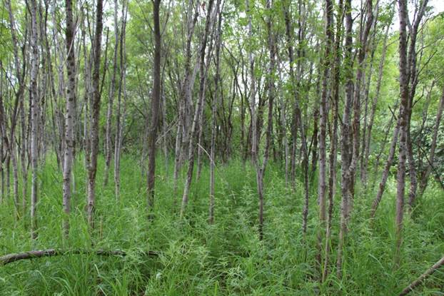
Fig. 12. Grass-grass willow on the middle floodplain of the Burgali river (photo by N. Sazanova) Cereal alders are confined to dry areas of medium floodplains that have left the floodplain regime. Here, more stable thickened overgrowths of shrub alder — Duschekia fruticosa (Rupr.) Pouzar.) are formed with rare participation: Rubus idaeus L.; Sorbaria sorbifolia L.; Ribes triste Pall., as well as sparse ground cover consisting mainly of Calamagrostis langsdorffii (Link) Trin. (fig. 13). 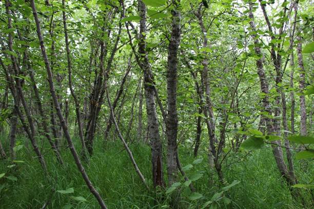
Fig. 13. Cereal alder on the middle floodplain of the Burgali river (photo by N. Sazanova) Mixed-grass and glacial meadows are formed on flood-flooded areas of low floodplains and coastal terraces. Calamagrostis langsdorfii (Link) Trin. dominates mainly in the composition of meadows; they participate to varying degrees, sometimes forming compacted sinusias: Chamaepegium angustifolium (L.); Ranunculus pygmaeus Wahlenb.; Arctanthemum arcticum (L.) Tzvel.; Tanacetum boreale Fisch. ex DC.; Chorisis repens (L.) DC; Leucanthemum ircutisnum DC; Geranium erianthum DC; Senecio pseudoarnica Less.; Leymus mollis (Trin.) Pilg., and also - Duschekia fruticosa (Rupr.) Pouzar (fig. 14). 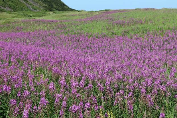
Fig. 14. A grassland meadow on the seaside spit of Cape Taran (photo by N. Sazanova) MORPHOLOGICAL AND GENETIC CHARACTERISTICS OF SOILS The soils of the Olsky section of the Magadan Nature Reserve are taxonomically represented by 2 trunks, 6 divisions, 10 types, 11 subtypes, 10 species and 3 varieties (Table 1). Table 1. List of mapped taxonomic units of soil cover 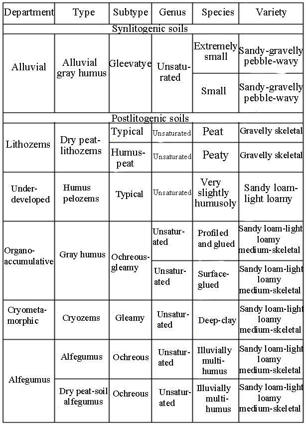 The continuation of the tal. 1. 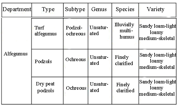
The soil cover of the Olsky site is mainly represented by subtypes of soils of the alphegumus sections of the postlithogenic trunk. Subtypes of other departments are rare inclusions of the general structure of his organization. In order to reduce the share of participation in the boundaries of the mapping area, the following subtypes of soils are present, %: - ochreous contours — 26; - sod–podzol-ochreous — 14; - dry peat-ochre podzoles -13; - ocher podzoles — 8; - dry peat-lithozems typical — 4; - dry peat-lithozems humus-peat — 4; - dry peat-ochreous — 3; - gray humus (turf) ochreous-gleevate — 3;
- alluvial gray humus (turf) gleevate — 2; - gleevate cryosystems — 1; - typical humus pelozems — 1. Ochreous podbures are formed under cedar elfin shrub-dead-cover (see Fig. 1) on gentle slopes and plumes composed of stony-gravelly-gravelly colluvial-deluvial deposits overlain from above by a low-power cover of fine-sanded volcanic ash (Fig. 15). 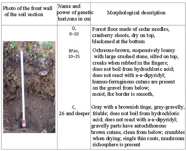
Fig. 15. Ochreous substructure in soil section No. 5-KONI-2015 (laid on August 15, 2015 on the plume of the northeastern exposure; abs. height — 861 m; coord. — 59° 9'14"SSH; 151°38'57"VD; 2.5 km south-east of Cape Plosky) These soils, like other subtypes of the Magadan Nature Reserve, have a light mechanical composition with a small accumulation of physical clay and silt in the upper part of the active layer, acidic and medium acidic reaction of the medium (pH — 4.45-5.01); increased values of hydrolytic acidity (26.35-94.80 mg-eq/100 g of soil), high concentrations of exchangeable hydrogen (21.47-35.60 mg-eq/100 g of soil) and humus (6.71-17.61%), relatively low content of the sum of exchangeable bases (6.93-30.95 mg-eq/100 g of soil) with the regression-accumulative nature of the distribution of these indicators according to the profile [31]. Allophane, an aqueous silicate of aluminum, a product of weathering of volcanic glass, an active source of amorphous forms of silica and aluminum, accumulates in these soils [24]. The sod-podbura podzol-ochreous are formed under cedar elfin shrub-moss (see Fig. 2) on steep bedrock slopes (35-40 o) of various exposures (Fig. 16) and slopes of marine terraces (Fig. 17), on layered rocky-gravelly solifluxes with a low-power cover of volcanic ash. 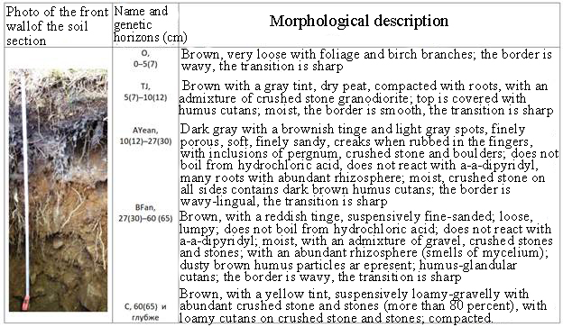
Fig. 16. Sod-podbur podzol-ochre in soil section No. 10–KONI–2015 (laid on August 15, 2015 on the root slope of the eastern exposure; abs. height — 133 m; coord. : 59° 8'51"SSH; 151°38'52"VD; 1.5 km south-east of Cape Plosky) 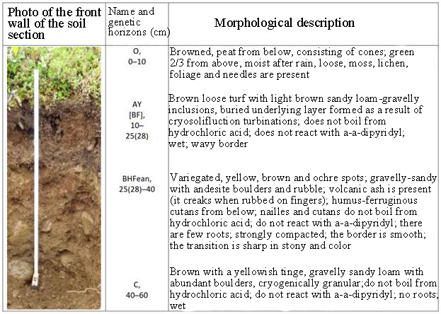 Fig. 17. Sod-podbur podzol–ochre in soil section No. 2-KONI-2015 (laid on August 15, 2015 on the steep slope of the sea terrace of the northern exposure; abs. height — 16 m; coord.: 59° 9'40"SSH; 151°38'37"VD; 0.1 km south of Cape Plosky) Soil data on physico-chemical and chemical properties differ little from ochreous podburs. Most likely, these subtypes differ only in the qualitative composition of humus. Thus, the humus of sod-podburs is more "soft" and less aggressive in composition, since it is formed from the fall of pine needles with a large admixture of root litter of grass sod. Dry peat-ochre podzoles are formed under cedar elfin shrub-moss (see Fig. 2) on the subhorizontal surfaces of upland terraces composed of colluvial-deluvial rocky gravelly-gravelly deposits overlain from above by a 10-15-centimeter cover of volcanic ash (Fig. 18). 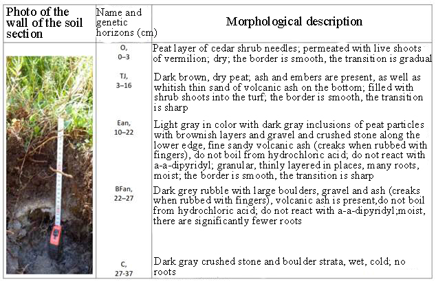
Fig. 18. Dry peat-ochre podzole in soil section No. 6-KONY-2015 (laid on August 15, 2015 on the surface of the upland terrace; abs. height — 123 m; coord.: 59° 9'03"SSH; 151°38'43"VD; 1.8 km south of Cape Plosky) These soils, as well as subtypes of dry peat-podzols of other areas of the Magadan reserve, have a light mechanical composition, acidic and slightly acidic reaction of the medium (pH — 4.25-6.05), increased hydrolytic acidity (94.80-102.90 mg-eq/100 g of soil), high content of exchangeable hydrogen (up to 40.50 mg-eq/100 g of soil) and humus (up to 22.20%), a relatively low content of the sum of exchange bases (up to 22.34 mg-eq/100 g of soil); characterized by an increased content of non-silicate forms of silicon, aluminum and iron in podzolic horizons and their very pronounced accumulation in illuvial horizons [31, pp. 97-98]. The listed properties confirm the above-mentioned features of the intra-soil weathering of volcanic ash particles of rheolitic composition, which perform the surface layer of the soil-forming rocks of the research site. Ochreous podzoles develop under cedar elfin shrubby-mossy (see Fig. 2), on the subhorizontal surfaces of ancient marine basement terraces framing the mountain structures of the Kony Peninsula, and overlain from above by layered sandy loam-gravelly solifluxes with inclusions of sea pebbles and boulders, and from above by a cover of volcanic ash with a thickness of up to 0.25 m (Fig. 19).
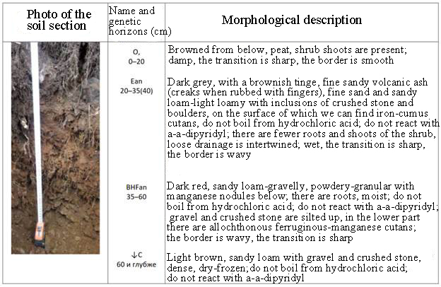
Fig. 19. Ochre podzole in soil section No. 3-KONI-2015 (laid on August 15, 2015 on the surface of the marine basement terrace; abs. height — 17 m; coord.: 59° 9'37"SSH; 151°38'39"VD; 0.2 km south of Cape Plosky) It can be seen that ochreous podzols differ from dry peat-ochreous podzols by the absence of dry peat horizons from above. In place of the latter, there is the presence of quite powerful detached forest litter. Their mineral strata have practically no differences. It follows from this that, in general, their chemical and analytical indicators should be very close to each other, that is, they are acidic, unsaturated, coarse-humus, strongly skeletal soils developing mainly in the surface 25-centimeter layer of volcanic ash. Dry peat-lithozems typically develop under mixed-grass and glacial meadows on the exposed surfaces of alluvial terraces composed of pebble-boulder deposits with layered sandy loam-gravelly aggregate (50%), without signs of the presence of volcanic ash (Fig. 20). 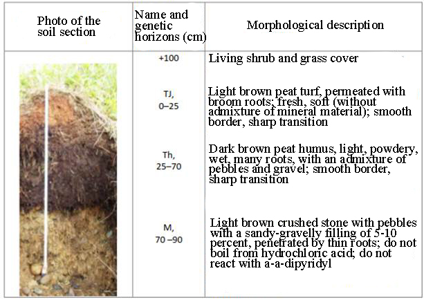
Fig. 20. Dry peat-lithozem typical section No. 4-KONI-2015 (laid on August 14, 2015 by stripping the left—bank cliff of the above—floodplain terrace of the Khindzha River; slope - 60o; abs. height - 6 m; coord.: 59° 9'39.47"SSH; 151°38'43.45"WD; 0.1 km south of Cape Plosky) These soils are similar in structure and properties to the dry peat soils of the Magadan Reserve and are characterized by an acidic reaction of the medium (pH — 4.6), accumulation of organic matter in the form of slightly decomposed peat (up to 38.35%), high hydrolytic acidity (up to 115.63 mg-eq/100 g of soil), biogenic accumulation of exchange bases (up to 41.34 up to 23.20 mg-eq/100 g of soil), total phosphorus, manganese, calcium, magnesium and potassium, but with a low degree of saturation with exchange bases (up to 19%), a narrow ratio of total carbon to total nitrogen (up to 16), a reduced content of specific substances (0.5-0.64) and amorphous iron, fulvate the composition of humus, which is dominated by fractions 1 of humic and fulvic acids (56-73% of total carbon in the soil) with a small content of the most aggressive fraction 1a of fulvic acids and the practical complete absence of the second fractions of humic and fulvic acids [31, pp.119-122]. Dry peat-lithozems humus-peat develop under dense thickets of green moss-sphagnum plantain (see Fig. 3), in some areas of steep bedrock slopes composed of colluvial-deluvial rocky gravelly-gravelly frozen deposits without signs of volcanic ash (Fig. 21). 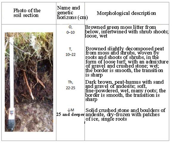
Fig. 21. Dry peat-lithozem humus–peat in soil section No. 8-KONY-2015 (laid on August 15, 2015 on a steep root slope (35-40o) of the northern exposure; abs. height — 81 m; coord.: 59° 9'13"SSH; 151°38'48"VD; 0.9 km south-east of Cape Plosky) Subtypes of dry peat-lithozems of humus-peat should be substantially similar in chemical and analytical characteristics to typical dry peat-lithozems, with the exception of a noticeable accumulation of more decomposed humus layers under their peat horizons, lying mainly on dry frozen rocky, well-drained sediments. They, as well as the latter, are characterized by an acidic reaction of the medium, accumulation of coarse humus organic matter of fulvate composition, high hydrolytic acidity, biogenic accumulation of chemical elements, but low saturation, narrow ratios of total carbon to total nitrogen, low content of specific substances and amorphous iron [see 31, pp.119-122]. Dry peat-ochreous podburs develop in stony-lichen, stony-shrubby (dryad or arctous) mountain tundra with prostrate cedar elanics (see Fig. 4, 5, 6) on stony sandy-gravelly with an admixture of volcanic ash particles eluvium and eluvium deluvium of mountain peaks, saddles and plateaus (Fig. 22). 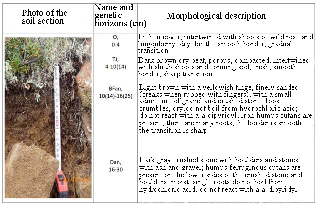
Fig. 22. Dry peat-ochreous podburge in soil section No. 10-KONI-2015 (laid on August 15, 2015; on a flattened mountain saddle; abs. height – 498.6 m; coord.: 59° 8'08"SSH; 151°37'29"VD; 1.5 km south of Cape Plosky) These soils are basically similar to ochreous podburs and differ from them only in the presence of high-capacity dry peat horizons, which cause a slight increase in humus, acidity and unsaturation, with a regression-accumulative distribution of these indicators according to genetic profiles. Gray humus (turf) ochreous-gleamy soils develop in nival willow–grass meadows (see Fig. 8), growing in flow-swampy glacial caves, nival niches and terraces. In the latter, surface runoff from the surrounding areas accumulates in the form of mudflow suspensions enriched with fine sand particles of volcanic ash. Thus, in these geomorphological elements of the alpine relief, a layered sandy-loamy proluvium is formed, which serves as a soil-forming rock for the designated soils (Fig. 23, 24). 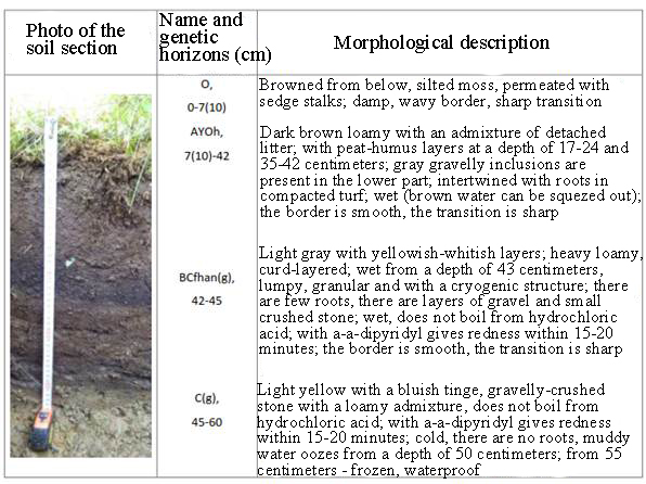
Fig. 23. Gray humus (turf) ochreous-gleamy soil in section No. 1-KONI-2015 (laid on August 12, 2015 under a wet nival meadow in the bottom of a flowing-swampy glacial kara with a lake; abs. height – 131 m; coord.: 59° 8'49.20"SH; 151°38'51.25"VD; 1.6 km south-east of Cape Plosky)
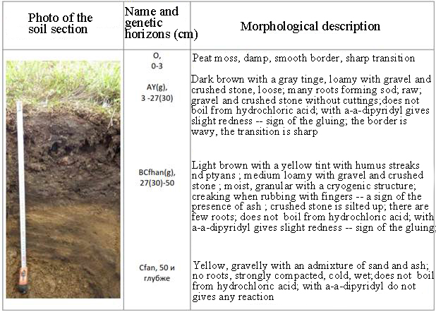
Fig. 24. Gray humus (turf) ochreous-gleamy soil in section No. 9-KONY-2015 (laid on August 15, 2015 under a grass meadow on the concave surface of a nival niche (terrace); abs. height – 302 m; coord.: 59° 8'43"SSH; 151°37'29"VD; 2.2 km southwest of Cape Plosky) These soils are characterized by a uniform accumulation of physical clay, a clay composition of fine-grained soil with an increased content of silty fraction (30%), fine sand (21-25%) and fine dust (13-16%), due to deluvial sorting of fine-grained fractions and biogenic accumulation of colloidal parts; enrichment with non-silicate forms of iron, (32-36% of its gross) weak differentiation their content in depth due to the layered sedimentation of fine-grained soil-forming rocks in conditions of increased moisture [31, pp. 67-69]. The studied soils are distinguished by the presence of amorphous silica in the form of a significant admixture of whitish particles of volcanic ash of rheolitic composition. Alluvial gray-humus (turf) gley soils develop on the above-floodplain terraces of local watercourses under shrubby grass poplar-chozen forests (see Fig. 11), mixed-grass and grassy willows (see Fig. 12) and cereal alders (see Fig. 13) on alluvial pebbles and boulders with an admixture of pechano-gravelly aggregate (Fig. 25). 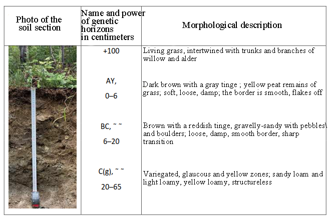
Fig. 25. Alluvial gray humus (turf) gley soil in section No. 11 -KONI-2015 (laid on August 16, 2015 on the ledge of the first right-bank high floodplain of the Khindzha River under a shrubby grass poplar–chozen forest; abs. height - 2 m; coord.: 59° 8'08"SSH; 151°37'29"VD; 0.5 km south-east of Cape Plosky) These soils are similar in genetic characteristics to alluvial gray humus (turf) typical soils of the Magadan Reserve and are characterized by contrasting stratification of genetic horizons, slightly acidic reaction of the medium (pH — 5.1-6.9) with increased values of hydrolytic acidity (9.7-73.4 mg-eq./100 g of soil) and the content of coarse organic matter of fulvate composition in the form of buried lenses of detached opal and detritus (humus according to Tyurin — 4.1–46.4%; Sg.k.: Cf.k.— 0.4–0.8); they are poorly differentiated in terms of gross composition; organogen elements accumulate in their turf horizons, and there is also a tendency to a weak accumulation of amorphous forms of iron [31, pp. 48-64]. Gleevate cryosemes develop in separate areas of the basement sea terraces and on the first above-flood river terraces, under the vegetation of the sedimentary sediment-fluff tundra with flattened low-growing bushes of cedar elfin (see Fig. 10) in the strata of gravelly gravelly loamy proluvium with a thickness of up to 1.5 m, overlapping these terraces from above (Fig. 26). 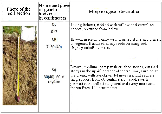
Fig. 26. Gleevaty cryozem in section No. 13-KONI-2015 (laid on August 19, 2015 on a basement sea terrace overlooking the left bank of the Khindzha River under a boarded-up pushy-sedge tundra with prostrate cedar elfin bushes; abs. height – 105 m; coord.: 58 o 57'20"VD; 151 o 38' 39.2"SSH; 1.5 km south-east of Cape Plosky) Gleevate cryozems are similar in genetic features to gleevate cryozems of the Seymchan section of the Magadan Reserve: they are composed mainly of dusty (48-61%) fractions of fine earth and silt (20-24%) formed during cryogenic transformations of soil—forming deluvial material; as a result of cryogenic mass transfer, these soils acquire increased indicators of coarse humus (humus according to Tyurin - 2.9-18.9 %) hydrolytic acidity (6.74-45.60 mg-eq/100 g of soil), amorphous iron content (1.0-13.35 %) and exchange bases (10.90-63.56 mg-eq/100 g of soil), wide values of C:N (9-14) [31, pp.81–82]. Typical humus pelozems develop on the burning of cedar planches, in areas of complete burning of vegetation and forest litter under Ivan-tea-veiny sinusias (see Fig. 9), in the near-surface strata of sandy loam-gravelly eluvium (Fig. 27). 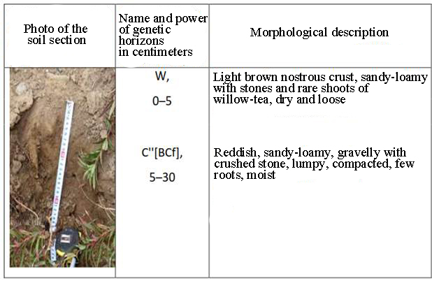
Fig. 27. Typical humus pelozem in section No. 12-KONI-2015 (laid on August 19, 2015 under the Ivan-chaevo-veinikov succession on a section of burnt cedar-plantain thicket, on a gentle plume, on a slope between the streams of the Bridge and Shrub; abs. height — 54 m; coord.: 59° 1248"SSH; 151°20'26"WD) in the thickness of sandy loam-loamy gravelly deluvium 2.8 km southwest of Cape Plosky) The development of typical humus pelozems within the boundaries of the Olsky site occurs on the site of ochre podburs and podzols degraded by fires. The surface mineral horizons of these soils, enriched with ash and coal dust, act as soil-forming rocks in relation to pelozems. Post-fire vegetation renewal is ensured by enrichment with mobile ash nutrients of a pyrogenic nature, as well as by mineralization of the root litter of herbaceous pioneers. As a result, newly formed pelozems in place of alphegumus soils acquire a slightly acidic reaction in the near-surface layer, saturation with exchange bases and organogen elements. The properties of the underlying horizons of pelozems are identical to those of the illuvial horizons of primordial soils. The structure of the soil cover
Due to the heterogeneity of the structural and corrective factors of the structural organization, 9 contours of the soil cover structures are distinguished on the soil map of the Olsky site (Fig. 28). Among them, the most widespread are rounded contours of variations of phytogenic spots of ochreous podburs with phytogenic spots of sod-podburs of illuvial-glandular ochreous, occupying 37% of its territory (Table 14). Less significant areas of the site (26%) are occupied by rounded contours of combinations of phytogenic spots of dry peat–ochre podzols and ochre podzols with phytogenic spots of dry peat-lithozems humus-peat. The prevalence of the remaining SPP contours on the site is sporadic, the area of each of them does not exceed 8%. The most exotic (1%) on the site are the rounded contours of the phytogenic spots of the ochreous gleam podzols. Table 2. Typification of the soil cover structure by landscape districts and districts | Constructive and corrective factors of the structural organization of the soil cover | The name of the contours | Geometric shapes of contour outlines | Wagon train-the beginning the contour- moat on the map | Plo-spare, ha | | Relief and soil-forming rocks | Plant communities | | A landscape area of mountain deserts and tundra | | Glacial circuses and karas, tectonic discharges and outcrops composed of rock massifs and rocky placers | - | - | - | - | 9742 | | Glacial lakes |
- | - | - | - | 139 | | Eluvial upland plateaus composed of rock massifs and rocky placers | Epilitic lichenized rocky mountain deserts | Mosaics of fields of rocky placers with spots of dry peat–lithozems typical | Amoebos are prominent | KR x Lzst | 8359 | | Rocky-lichen and rocky-shrubby mountain tundra with prostrate cedar elfin | Mosaics of lithogenic spots of dry peat-ochre podburs with fields of stony placers | Amoebos are prominent | PBsth x KR | 5162 | | Landscape district of mountainous and mountain-valley tundra forests (cedar elms) | | Steep mountain slopes of the southern exposure, composed of rocky placers with a fragmentary surface cover and layers of rhyolite tephra |
Groves of stone birch | Phytogenic spots of sod-podburs of podzol-ochreous | Oval | PBdoph | 345x7 | | Mountain slopes and plumes composed of eluvial-deluvial deposits with a surface cover and layers of rhyolite tephra | Cedar planches shrubby-dead-cover in association with cedar planches herbaceous shrubby-moss on old fires | Variations of phytogenic spots of ochreous podburs with phytogenic spots of sod-podburs of illuvial-glandular ochreous | Rounded | PBx : PBDIH | 38186 | | Cedar planches are shrubby-mossy in association with cedar planches are green-mossy-sphagnum | Combinations of phytogenic spots of dry peat-ochre podzols and ochre podzols with phytogenic spots of dry peat-lithozems of humus-peat | Rounded | [(Posth Poh)+Lztp] | 26962 | | Landscape district of mountainous-terraced-hilly tundra forests | |
Upland niches and terraces composed of proluvial and eluvial-deluvial deposits with an admixture of rhyolite tephra | Nival willow-grass meadows | Phytogenic spots of gray humus (turf) ochreous-gleamy soils | Oval and ribbon-shaped | Goodgh | 3018 | | Zakochkaren sedge-fluff tundra with prostrate cedar elfin | Phytogenic spots of ochreous glaucous podzoles | Rounded | Pogh | 860 | | Pyrogenic Ivanchaevo-veynikov successions | Mosaics of fields of rocky placers with phytogenic spots of typical humus pelozems | Rounded | KR x Pzgug | 2025 | | Landscape area of valley-river tundra forests and forests | | Coastal and low floodplains, dissected by channels and fluvial trickle-ridge microrelief with areas of littered sand and pebble spit and beaches |
Shrubby grassy poplar-chozen forests in association with grass-grass–willow and veiny sinusias | Mosaics of fields littered with sandy and pebble beaches with lithogenic spots alluvial gray humus (turf) gley soils and phytogenic spots of dry peat-lithozems typical | Ribbon–shaped | GP x (Aldg.Ald) x Lzst | 3091 | | Landscape area of laide tidal and abrasive coastal tundra forests, meadows, beaches, scree and cliffs | | Coastal cliffs (cliffs) | - | - | - | - | 1649 | | Marine boulder and pebble beaches | - | - | - | - | 776 |
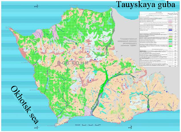
Fig. 28. Soil map of the Olsky section of the Magadan Nature Reserve conclusion The obtained cartographic and morphological-genetic information allows us to conclude that the soil cover on the Olsky site of the Magadan reserve is represented by rounded variations of phytogenic spots of ochreous podburs with phytogenic spots of sod-podburs of illuvial-ferruginous ochreous and combinations of phytogenic spots of dry peat-podzols ochreous and podzols ochreous with phytogenic spots of dry peat-lithozems humus- peat. The remaining soil combinations, including phytogenic spots of ochreous glaucous podzols, have a limited prevalence. Almost all of these "ochreous" subtypes belong to the alphegumus department of soils of two types: podzols and podburs, formed under cedar elms in the residual near-surface layer of eroding volcanic ash covers with a thickness of no more than 0.25 m, introduced from the relict volcano — caldera of Kuril Lake (southern Kamchatka) approximately 8.5 thousand years ago. Along with these subtypes, a subtype of "ochreous" soils of the type of gray humus (turf) organo-accumulative department is formed under meadow vegetation in the accumulative forms of the alpine-type relief of the Olsky site. The genesis of the latter is closely related to the processes of fluvial separation and layered sedimentation, volcanic ash cover and products of their weathering in negative relief forms as part of layered, sandy loam-loamy excessively flow-moistened proluvial-deluvial sediments. During the specified period of time after the introduction of tephra, the current surface erosion processes completely destroyed the once solid ash cover on well-drained positive elements of the local microrelief and steep slopes. Where the ash cover has completely degraded due to erosion processes, rocky outcrops and stony placers of different genesis have "come to the surface". These non—soil formations formed the basis for the formation of local combinations - mosaics with subtypes of departments of alluvial soils and lithozems. The role of ash material in the genesis of underdeveloped (humus pelozems) and cryometamorphic (gleevate cryozems) soils remains somewhat unclear. This is probably due to the general imperfection of its diagnosis in the total masses of soil horizons experiencing active cryogenic mass transfer processes. Thus, the ancient surface cover of rhyolite tephra plays a fundamental role in the soil formation of the Olsky site. It is of great scientific interest to further generalize and clarify information about the diagnosis and geography of the distribution of layered ash soils on the mainland of Northeast Asia. The obtained materials convince us that the Olsky site, as well as the entire Northern Piokhotye, is located in the zone of active influence of ancient and modern Kamchatka volcanism on soil formation. Due to the Aeolian spread of ash material, this entire vast region is undergoing gradual, and sometimes catastrophic, surface lithogenic "renewal" and growth. It would seem that this long-obvious fact for volcanologists should have prompted changes in the existing paradigm of formation in the research area of podzols in general and the process of podzolization in particular. But this has not happened yet, due to the difficult diagnosis of the presence of ash material and products of its weathering in soils, on the one hand, and also, probably, due to the general sharp decrease in research activity in the geography of soils of this vast region, on the other.
References
1. Alfimov, A.V. (2006). Temperature differentiation and vertical zonation of the coast. Landscapes, climate and natural resources of the Tauiskaya Bay of the Sea of Okhotsk, pp. 138-156. Vladivostok: Publishing House of Dalnauka.
2. Andreev, D.P., Ignatenko, I.V., & Mazhitova, G.G. (1981). Primitive organogenic gravelly soils of the Extreme North-East of the USSR. Magadan: IBPS DVNTs of the USSR Academy of Sciences.
3. Baranova, Yu.P., & Biske, S.F. (1964). The history of the development of the relief of Siberia and the Far East. North-East of the USSR. Moscow: Nauka Publishing House.
4. Berkutenko, A.N., Dokuchaeva, V.B., & Polezhaev, A.N. (1989). Flora and vegetation of the Magadan Nature Reserve. Issue 1. The North Okhotsk part. Magadan: SVKNII FEB RAS.
5. Galanin, A.A., Glushkova, O.Yu., & Smirnov, V.N. (2006). The Late Quaternary history of the development of relief, climate and vegetation. Landscapes, climate and natural resources of the Tauiskaya Bay of the Sea of Okhotsk, pp. 51-69. Vladivostok: Publishing House of Dalnauka.
6. Geology of the USSR. (1970). The North-East of the USSR. Geological description. Vol. 30. Book 2. Moscow: Publishing house of the Subsoil.
7. State Geological Map. (1992). M-b 1:1000000 (new series) Sheet O-56 – Magadan; R-56, 57 – Seimchan and Explanatory note. Ed. by M.L. Gelman. St. Petersburg: VSEGEI Publishing House.
8. Zamolotchikov, S.A. (1989). Priokhotsky region. Geocryology of the USSR. Eastern Siberia and the Far East, pp. 351-362. Moscow: Publishing House of the Subsoil.
9. Zamoshch, M.N., Dmitriev, A.I., & Motorov, O.V. (2006). Hydrology, hydrogeology and geocryology of the coast. Landscapes, climate and natural resources of the Tauiskaya Bay of the Sea of Okhotsk (pp. 157-172). Vladivostok: Publishing House of Dalnauka.
10. Ignatenko, I.V., Bogdanov, I.E., & Pugachev, A.A. (1980). Podzolic Al-Fe-humus soils of the Magadan region. Geography and genesis of soils of the Magadan region, pp. 123-142. Vladivostok: Publishing House of the DVNTs of the USSR Academy of Sciences.
11. Ignatenko, I.V., Naumov, E.M., Bogdanov, I.E., Mazhitova, G.G., & Pavlov, B.A. (1982). Soil-geographical zoning of the Extreme North-East of the USSR. Soils of islands and oceanic regions of the Pacific Ocean: proceedings of the 16th Pacific Scientific Congress, pp. 44-96. Vladivostok: Publishing House of the DVNTs of the USSR Academy of Sciences.
12. Ignatenko, I.V., Pugachev, A.A., & Bogdanov, I.E. (1977). Morphological and genetic characteristics of soils of the hospital territory. Components of biogeocenoses of tundra forests of the Northern Okhotsk Sea, pp. 62-10. Vladivostok: Publishing House of the DVNTs of the USSR Academy of Sciences.
13. Ignatenko, I.V., & Khavkina, N.V. (1980). Podbury of the Far East of the USSR. Geography and genesis of soils of the Magadan region, pp. 93-117. Vladivostok: Publishing House of the DVNTs of the USSR Academy of Sciences.
14. Klyukin, N.K. (1970). Climate. The North of the Far East, pp. 101-132. Moscow: Nauka Publishing House.
15. Kryuchkov, V.V. Treelessness of the tundra zone of Northeastern Siberia and its causes. Izv. AN USSR. Ser. Geogr, 4, 97-105.
16. Mazhitova, G.G. (1988). Soils and soil cover of the Magadan Nature Reserve. Kava-Chelomdzhinsky site: preprint. Magadan: Publishing House of the Central Research Institute of the Far East of the USSR Academy of Sciences.
17. Melekessev, I.V., Glushkova, O.Yu., Kiryanov, V.Yu., Lozhkin, A.V., & Sulerzhitsky, L.D. (1991). Origin and age of Magadan volcanic ash. Dokl. USSR Academy of Sciences, 5, 1192.
18. Naumov, E.M. (1963). Soils of the southern part of the Magadan region within the Okhotsk coast. On the soils of Eastern Siberia, pp. 153-195. Moscow: Publishing House of the USSR Academy of Sciences.
19. Naumov, E.M. (1968). Soils of the northern coast of the Sea of Okhotsk. Abstract of the dissertation of the Candidate of agricultural sciences. Moscow: TSKHA.
20. Naumov, E.M. (1970). Floodplain turf soils of the Magadan region as a reserve for increasing the arable fund. Tr. of the Magadan zonal Research Institute of the North-East. Vol. 1, pp. 177-182. Magadan: Magadan Book Publishing House.
21. Naumov, E.M. (1971). Soils of the Magadan region and their agrochemical characteristics. Agrochemical characteristics of soils of the USSR Far East, pp. 240-313. Moscow: Publishing House Nauka.
22. Naumov, E.M. (1973). The main types of genetic soil profiles and features of the soil cover of the taiga zone of the Far Northeast. Soils and vegetation of permafrost regions of the USSR. Mat. V simp, pp. 29-41. Magadan.
23. Naumov, E.M., & Degrees, B.P. (1974). Features of soil formation in the Extreme North-East of Eurasia. Moscow: Kolos Publishing House.
24. Naumov, E.M., & Degrees, B.P. (1964). Features of soil formation on the northern coast of the Sea of Okhotsk. Permafrost soils and their regime, pp. 28-99. Moscow: Nauka Publishing House.
25. Naumov, E.M., Degrees, B.P., & Tsyurupa, I.G. (1974). On taiga soil formation in the North-East of the Siberian permafrost region. Soil cryogenesis, pp. 34-77. Moscow: Nauka Publishing House.
26. Naumov, E.M., & Savich, V.I. (1964). Alluvial soils of the Priokhotsky districts of the Magadan region and their agricultural significance. Dokl. TSHA, 99, 87-94.
27. Scientific and applied reference book on the climate of the USSR. (1990). Ser. 3. Long-term data. Part 1-6. Issue 33. Magadan region, Chukotka Autonomous Okrug of the Magadan Region. L.: Hydrometeoizdat.
28. Ogureeva, G.N. (1998). The structure of the high-altitude vegetation zone of the mountains of the North-East of Siberia. Geography and Natural Resources, 2, 5-11.
29. Pavlov, B.A. (1991). Soils and soil cover of the Yamsky forestry State Reserve "Magadan". Magadan: IBPS FEB RAS.
30. Pavlov, B.A. & Zamoshch, M.N. (2006). Landscape structure of the coast. Landscapes, climate and natural resources of the Tauiskaya Bay of the Sea of Okhotsk, pp. 100-116. Vladivostok: Publishing House of Dalnauka.
31. Pavlov, B.A., & Mazhitova, G.G. (2015). Soils and soil cover of the Magadan Reserve. Scientific research in the Magadan Reserve, pp. 37-148. Moscow: ANO Publishing House "Scientific Review".
32. Ponomareva, V.V. (2010). The largest exlosive volcanic eruptions and the use of their tephra for dating and corelation of landforms and sediments. Abstract of dissertation of the Doctor of Geographical Sciences. Moscow: Institute of Geography of the Russian Academy of Sciences.
33. Soil map of Magadan. (1990). M-b 1:2500000. Ed. by L.L. Shishov. Moscow: Publishing House of the GUGK at the Council of Ministers of the USSR.
34. Reutt, A.T. (1970). Vegetation. The North of the Far East, pp. 259-299. Moscow: Nauka Publishing House.
35. Rozanov, B.G. (1983). Morphology of soils. Moscow: Publishing House of Moscow. Unita.
36. Targulyan, V.O., Karavaeva, N.A., Naumov, E.M., Sokolov, I.A., & Rozov, N.N. (1970). Soils. The North of the Far East, pp. 234-256. Moscow: Nauka Publishing House.
37. Friedland, V.M. (1972). Structure of soil cover. Moscow: Mysl.
38. Shishov, L.L., Tonkonogov, V.D., Lebedeva, I.I., & Gerasimova, M.I. (2004). Classification and diagnostics of soils in Russia. Smolensk: Publishing House of the Oikumen.
39. Horton, R. E. (1945). Erosional development of streams and their drainage basins: hydro-physical approach to quantitative morphology. Geological Society of America Bulletin, 3, 275-370.
Peer Review
Peer reviewers' evaluations remain confidential and are not disclosed to the public. Only external reviews, authorized for publication by the article's author(s), are made public. Typically, these final reviews are conducted after the manuscript's revision. Adhering to our double-blind review policy, the reviewer's identity is kept confidential.
The list of publisher reviewers can be found here.
The subject of the study, according to the author, is the survey and analysis of the Olsky section of the Magadan Nature Reserve (Koni Peninsula) to create a map of the soil cover of the studied site of the landfill. Research methodology based on the analysis of the article, it can be concluded that modern domestic teachings on diagnostics, their structural and spatial organization and classification of soils, as well as the method of cartographic modeling based on a publicly available topographic map of the Koni Peninsula, can be used as a methodological basis for diagnostics and nomenclature of soils, as well as mapping of the soil cover of the Olsky reserve "Magadan". 1:100000, as well as field and laboratory materials of morphological descriptions of relief and microrelief, plant communities and their species composition, structural organization of soil contours and individual genetic profiles of soil subtypes. The author also used the method of literary analysis, comparative characteristics of geographical objects and processes, and the method of constructing diagrams. The relevance of the topic raised is due to the fact that until now reliable information about the soils and soil cover of the Olsky section of the Magadan Reserve was completely absent and was of an assumed nature, due to its difficult accessibility. In this regard, four soil contours are indicated on the soil map of the Magadan region within the boundaries of this site: illuvial-multi-humus dry-peat dry-frozen podzols, tundra podzols without separation, illuvial-humus and ferruginous-humus podzols without separation dry-frozen, primitive gravelly. The presence of ash material in the listed soils is not marked on the map at all. The author filled this gap. The scientific novelty lies in the author's attempt to classify soils and differentiate them based on the conducted research. The obtained materials convince us that the Olsky site is typical for the entire Northern Piokhotye in the zone of active influence of ancient and modern Kamchatka volcanism on soil formation. It is noted that due to the Aeolian spread of ash material, this entire vast region is undergoing gradual, and sometimes catastrophic, surface lithogenic "renewal" and growth. Due to the difficult diagnosis of the presence of ash material and its weathering products in soils, on the one hand, and also due to the general sharp decrease in research activity in the geography of soils in this vast region, on the other, so far there has been no change in the existing paradigm of formation in the research area of podzols in general and the process of podzolization in particular. Style, structure, content the style of presentation of the results is quite scientific. The article is provided with rich illustrative material reflecting the process of creating a Soil map of the Olsky section of the Magadan Nature Reserve. Tables, photographs and diagrams are illustrative, the bibliography is very comprehensive for the formulation of the issue under consideration, but does not contain references to regulatory legal acts. The appeal to the opponents is presented in identifying the problem at the level of available information obtained by the author as a result of the analysis. Conclusions, the interest of the readership in the conclusions there are generalizations that allow us to apply the results obtained. The target group of information consumers is not specified in the article.
Link to this article
You can simply select and copy link from below text field.
|
|


