|
MAIN PAGE
> Back to contents
Historical informatics
Reference:
Malyshev A.A., Dryga D.O., Mochalov A.V., Moor V.V.
Digital Technologies to Reconstruct Anthropogenic Landscapes of Ancient Sindika
// Historical informatics.
2019. № 4.
P. 108-121.
DOI: 10.7256/2585-7797.2019.4.31622 URL: https://en.nbpublish.com/library_read_article.php?id=31622
Digital Technologies to Reconstruct Anthropogenic Landscapes of Ancient Sindika
Malyshev Aleksey Aleksandrovich
PhD in History
Head of department, Department of Scythian and Sarmatian Archeology, Institute of Archeology of the Russain Academy of Sciences
117292, Russia, g. Moscow, ul. Dm. Ul'yanova, 19

|
maa64@mail.ru
|
|
 |
Dryga Danila Olegovich
Leading engineer, Moscow State University of Geodesy and Cartography
105064, Russia, g. Moscow, ul. Gorokhovskii Per., 4

|
hopkuh@mail.ru
|
|
 |
Mochalov Aleksandr Valer'evich
Specialist, Projects Department, Moscow State University of Geodesy and Cartography
105064, Russia, g. Moscow, ul. Gorokhovskii Per., 4

|
al.mochalov93@gmail.com
|
|
 |
|
Moor Vyacheslav Vital'evich
Free researcher, Lomonosov Moscow State University
119192, Russia, g. Moscow, ul. Lomonosovskii Prospekt, 27/4

|
moor_v@mail.ru
|
|
 |
|
DOI: 10.7256/2585-7797.2019.4.31622
Received:
05-12-2019
Published:
20-12-2019
Abstract:
The article describes the results of the complex archeological studies in the northern part of historical Sindika which aimed at collecting and analyzing data on the elements of the ancient anthropogenic landscape in the region. The most importantsettlement in Sindika and Bosporan State was Semibratnee Gorodishche which developed and blossomed due to the proximity to navigable Kuban' River. Two kilometers away from the gorodishche there are Bol'shie Semibratskie Burial Mounds. To search for anthropogenic relief elements photogrammetry has been used. Site aerial photography provided for the necessary information about the relief. To get more precise and better data the authors carried out high-precision geodetic ties with the help of GPS receivers which provide for getting data on the plan and height location of objects with accuracy to centimeters. Digital aerial photography allows one to capture the modern landscape which changes in the region understudy are very rapid in the last decade. The effectiveness and the speed of archaeological research increases thanks to aerial photography. One can examine bigger objects within a short time period. At the same time, photogrammetry data processing provides for the demanded precision of work while the spatial super resolution attracts the researcher's attention to objects unseen during land surveys. Collection and visualization of data in GIS provide big opportunities to structure materials. Digital environment makes it possible to tie different and time heterogeneous sources thus often allowing a researcher to locate an object and its digital reconstruction within a lost historic anthropogenic landscape.
Keywords:
Sindica, orthophotomap, mounds, Bosporus state, photogrammetry, ancient settlement, visualization, anthropogenic landscape, complex research, antiquity
This article written in Russian. You can find original text of the article here
.
Топоним Синдика на азиатском Боспоре известен как в произведениях античных авторов, так и в памятниках боспорской эпиграфики. Ряд античных авторов (Гекатей Милетский (fr. 166) и Геродот (IV, 28) сообщают о Синдике, как о регионе (хорониме), получившем свое название от населяющего эту область варварского (негреческого) племени синдов, известных своими кроткими нравами (Псевдо-Арриан (65)).
В новелле Полиена (VIII, 55) упомянуты владения царя синдов Гекатея. Дискуссия о существовании синдского государства, в основе которой вопрос о принадлежности серий монет с надписью ΣΥΝΔΩΝ (синдов), благодаря исследованиям состава этих монет, эпиграфической находке на Семибратнем городище и последующим комплексным археологическим исследованиям [1, с. 228-232].
В то же время, в сообщениях Диодора (ХХ, 26) и Страбона (XI, 2, 1, 10, возможно 12) Синдика представлена как область Боспорского царства, причем топоним Синдика упоминается и как название области, и как ойконим - название населенного пункта (Геродот (IV, 86)). В «Перипле» Псевдо-Скилака (72) упоминаются располагавшиеся на ее территории боспорские города: «В Синдской области есть место Горгиппия - царская столица синдов, недалеко от моря, а также Аборака». Кроме того, в письменных источниках названы Синдик и Синдская Гавань. Археологическими данными подтверждено местонахождение античной Горгиппии (Синдской гавани) [2] и столицы синдов Лабриса [3, c. 34-47].
Довольно обширная историография существует о границах Синдики [4, c. 11-15]. К сожалению, материалы письменных источников не позволяют локализовать ни земли древних предгорий - синдов, ни Синдику - область азиатского Боспора. В наиболее обобщенном виде представление об ареале обитания синдов было сформулировано Н.В. Анфимовым: «Синды жили на Таманском полуострове и на прилегающей части Черноморского побережья до Анапы и далее до района станиц Раевской-Натухаевской. Северной границей Синдики являлась река Кубань, а на востоке территория ее простиралась, по-видимому, до хутора Красно-Батарейного, где расположены остатки древнего города со сложной системой укреплений» [5, c. 90]. По мнению Т.В. Блаватской, синды обитали в нижнем течении Гипаниса (Кубани), поэтому предложила не включать в этот ареал Таманский полуостров [6, с. 94]. Ее гипотеза подтверждается и материалами о наличии обширного пролива, отделявшего Таманский архипелаг от предгорий Северо-Западного Кавказа, и практически полным отсутствием там аборигенных захоронений [4].
Ареал археологических памятников, связываемых с обитателями предгорий (синдами), со времен Ю.С. Крушкол явно тяготеет к западным отрогам Главного Кавказского хребта, а Синдика у Страбона (Strabo. VII, IV, 6) названа одним из наиболее хлебородных районов Северного Причерноморья. Таким образом, они оказались связанными с разными природно-географическим зонами: боспорская Синдика не только развитый в земледельческом отношении регион, ориентированный на способствующие посреднической торговле морские и речные коммуникации, а в ареале примитивного традиционного комплексного хозяйства синдов (VIII-II в. до н.э.) в предгорьях Северо-Западного Кавказа издавна практиковалось конно-пешеходное сообщение (Рис. 1).
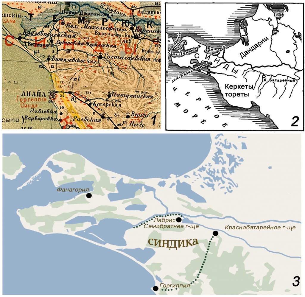
Рис. 1. Ареал расселения синдов: 1 – по Е.Д. Фелицыну (1882 г.); 2 – по В.П. Шилову (1950 г.). Синдика Боспорского государства (3).
Черноземными почвами известны открытые степные и лесостепные пространства черноморского побережья и надпойменных террас Закубанья. Ареалом античных усадеб-производителей товарного хлеба очерчено пространство, которое может быть определено как хозяйственная периферия (хора) античной Горгиппии [7, рис. 2, 2].
* * * * *
В предлагаемой статье освещены результаты комплексных исследований археологических памятников северной части исторической Синдики (Рис. 1, 2), задачей которых было сбор и аналитическая обработка информации об элементах антропогенном ландшафте в античную эпоху в регионе. Бассейн Кубани и ее притоков оказался насыщен земледельческими поселенческими структурами в гораздо меньшей степени. Тем не менее, античный облик и масштабность удаленных от черноморского побережья на десятки километров археологических памятников свидетельствуют о греческом проникновении в позднеархаическую эпоху. Основанные древними греками фактории со временем превращаются в городские боспорские центры, о которых античная письменная традиция, к сожалению, умалчивает. Наиболее значимое в истории Синдики и Боспорского государства – Семибратнее городище, стремительный рост и процветание которого было обеспечено близостью к судоходным протокам Кубани. Речная магистраль обеспечивала доступ к зерновым житницам Среднего Прикубанья, тем самым приумножая славу хлебородной Синдики [8, с. 69-73].
В значительном, около 2 км, удалении от городища, на вершине самой восточной из возвышенностей (их высота в пределах 40-120 м, самая высокая — Красная Горка), образующих высокий берег Старой Кубани, находятся Большие Семибратние курганы. Их разделяет долина реки Капиляпсин — одного из многочисленных притоков Кубани. В настоящее время долина распахана, тем не менее, на космосъемке отчетливо видны следы сухопутных трасс, ориентированных на Семибратнее городище. Курганные насыпи Малого Семибратнего могильника, расположенные некогда западнее городища (рис. 2), по всей видимости, образовывали своеобразную аллею курганов вдоль этих дорог.
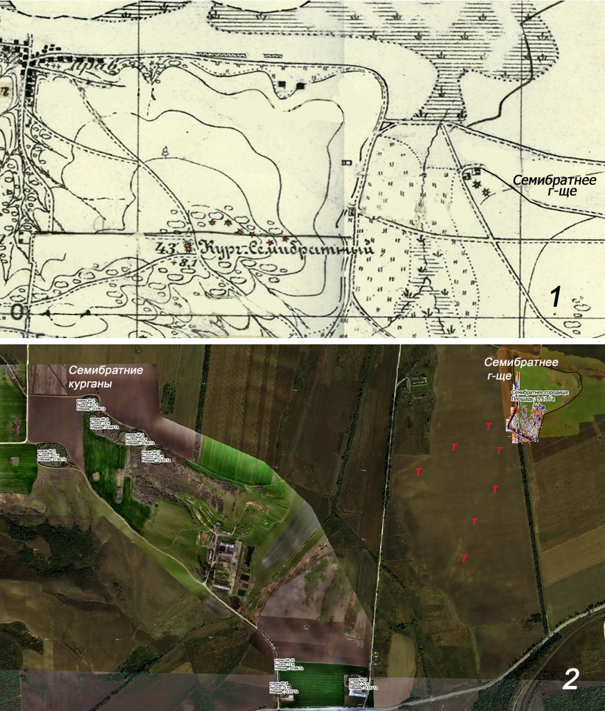
Рис. 2. Памятники северной части Синдики – Семибратнее городище и Семибратние курганы: 1 – на карте Генштаба 1909 г. с полуинструментальной рекогносцировкой 1931 г.; 2 – на базовом слое из ортофотопланов и космических снимков (Т - следы трасс древних дорог).
Хотя их изучение (раскопки) было начато давно, во второй половине XIX века, тем не менее, сведения об этом комплексе разрозненны, зачастую ограничены словесными описаниями (ОАК за 1875, СПб, 1878; ОАК за 1876, СПб, 1879). К сожалению, часть объектов (например, Малые Семибратние курганы (рис. 2, 1)) этого комплекса утрачена навсегда, в многочисленных публикациях о Больших Семибратних курганах систематизированы материалы раскопок 1880-х годов.
Более привлекательной для исследования оказалась площадь городища ‒ некогда крупного политического городского центра государственного образования античного облика [Лабрис: 3, с. 34-47; 1, с. 225-232), расположенного на краю левой надпойменной террасы в непосредственной близости от судоходной, возможно, еще в XIX в. старицы Кубани. Ещё в 1878 г. В.Г. Тизенгаузеном на городище были проведены рекогносцировочные археологические работы, которые выявили остатки оборонительных сооружений необычно хорошей сохранности (ОАК за 1878-1879. 1881. С. VIII-IX). На протяжение девяти полевых сезонов 1937-1953 гг. экспедиция Краснодарского краевого музея под руководством Н.В. Анфимова вела исследования в северной, вытянутой на 360 м вдоль старого русла Кубани, и восточной частях городища. Форма прибрежной части городской территории, видимо, представляет собой результат первоначальной довольно беспорядочной застройки районов, прилегающих к порту, подчеркивая эмпориальный статус Лабриса [1, с. 228] (рис. 3).
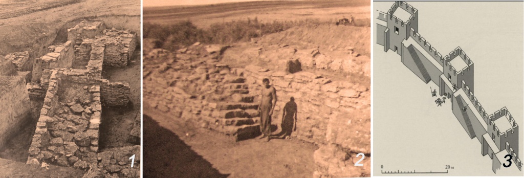
Рис. 3. Семибратнее городище: 1,2 – руины фортификационных сооружений (раскопки Н.В. Анфимова, 1952); 3 – графическая реконструкция В.П. Толстикова (2010).
Масштабы раскопок в меньшей по размерам (ок. 2,4 га) и более правильной по форме южной наиболее возвышенной части городища (общая площадь не превысила 200 м2), несмотря на довольно длительный период исследования (2000-2006), не позволяют получить целостную картину топографии и особенностей планировки.
Открытое пространство памятника существенно облегчило использование неразрушающих методик исследования. Анализ материалов топо- и аэрофотоматериалов, а также геомагнитная и георадарная съемка существенно расширили масштабы и результативность исследовательских работ (Рис. 5, 2). В частности, получено более определённое представление о топографии южной части города (сооружения на теменосе и возможные производственные комплексы) [9, с. 58-62].
Продолжение исследований этого комплекса раскопками, бесспорно, целесообразно, однако предполагает наличие значительной по финансированию научно-исследовательской программы, которая позволит раскрыть большие площади. Более актуальным представляется продолжение обследование этих памятников неразрушающими методами, которые позволяют расширить наши представления о них, создают прочную основу для организации охранных мероприятий и возможных раскопок.
В 2017-2018 гг. на указанных объектах был проведен комплекс работ, которые представлял собой комбинацию тахеометрической, аэрофототопографической и космической съемок с целью создания планов, трехмерных моделей, ортофотопланов и карт высот. Это позволило уточнить взаиморасположение объектов на курганном некрополе в настоящее время и предложить вариант реконструкции археологических объектов в современном, цифровом формате.
Фотограмметрические исследования выполнялись для выявления элементов антропогенного рельефа. Основная часть объекта находится на территории действующих сельскохозяйственных угодий с полосой лесонасаждений, в связи с чем работы на объекте проводились в зимнее время года, когда влияние растительности на рельеф минимизировано. На данном объекте площадью около 20 га выполнена площадная съёмка с малых высот, позволившая оперативно получить требуемую информацию о рельефе. Для получения более точного и качественного материала выполнялась высокоточная геодезическая привязка с использованием современных GPS-приемников, позволяющих получить информацию о плановом и высотном расположении объектов с сантиметровой точностью. Для обеспечения необходимой точности, в 2017 году был получен каталог координат и высот пунктов Государственной геодезической сети и выполнено определение параметров перехода от системы координат WGS 84/UTM zone 37N в систему координат Краснодарского края МСК 23 Зона 1 и МСК 23 Зона 2. Перед началом выполнения работ проводились контрольные измерения на пунктах ГГС в целях контроля точности и оценки работы приемника.
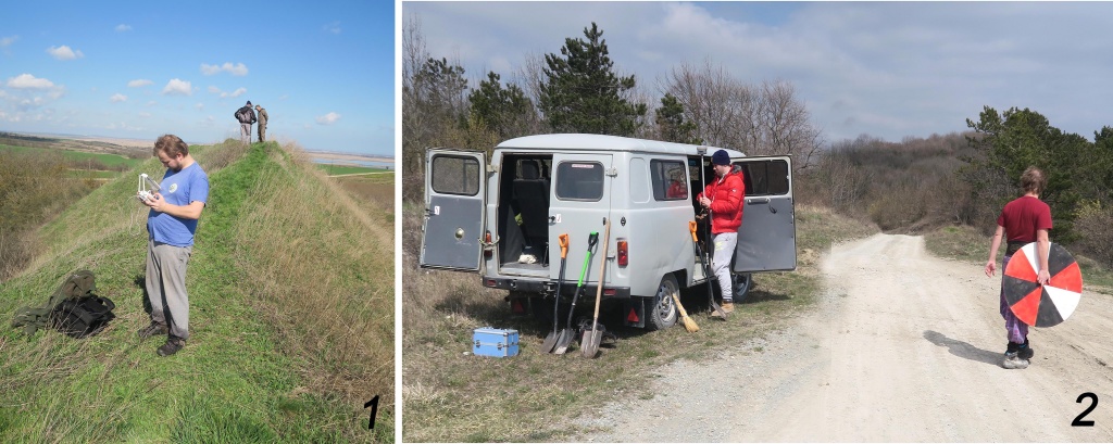
Рис. 4. Полевые работы на объектах.
В качестве опорных точек использовались опознаки в форме круга, разбитые на сектора, включающие в себя белый, черный и красный цвет (наиболее редко встречающиеся в природе цвета), что позволило быстро отождествить их положение на местности и осуществить привязку (Рис. 4, 2). Использование общей системы координат на всех объектах помогло структурировать и систематизировать полученные данные в общей системе плановых координат и высот. На участках, покрытых плотной растительностью даже в зимний период проведения работ, выполнялась тахеометрическая съемка с использованием электронного тахометра. В результате работы на объекте были представлены цифровая матрица высот и ортофотоплан. Объединение материалов аэрофотосъёмки и магниторазведки позволило с высокой достоверностью определить внешние границы укреплений.
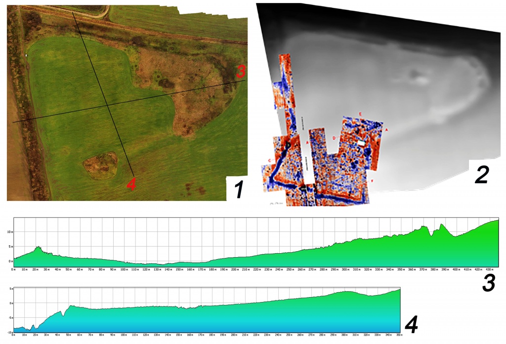
Рис. 5. Семибратнее городище: 1 – ортофотоплан; 2 – матрица высот совмещенная с данными магниторазведки совмещенный с данными магниторазведки Т.Н. Смекаловой (2006-2008 гг.); 3 – сечение по оси ЗВ; 4 – сечение по оси СЮ.
На основе полученных археологическими раскопками данных В.П. Толстиковым была предложена графическая реконструкция участка крепостных сооружений [10, рис. 15] (Рис. 3, 3). В настоящее время, в цифровом формате визуализация основных составляющих (куртин и башенных сооружений) фортификации Семибратнего городища классического времени была успешно совмещена с полученной в полевых условиях фотограмметрической моделью площади городища (Рис. 5-7).
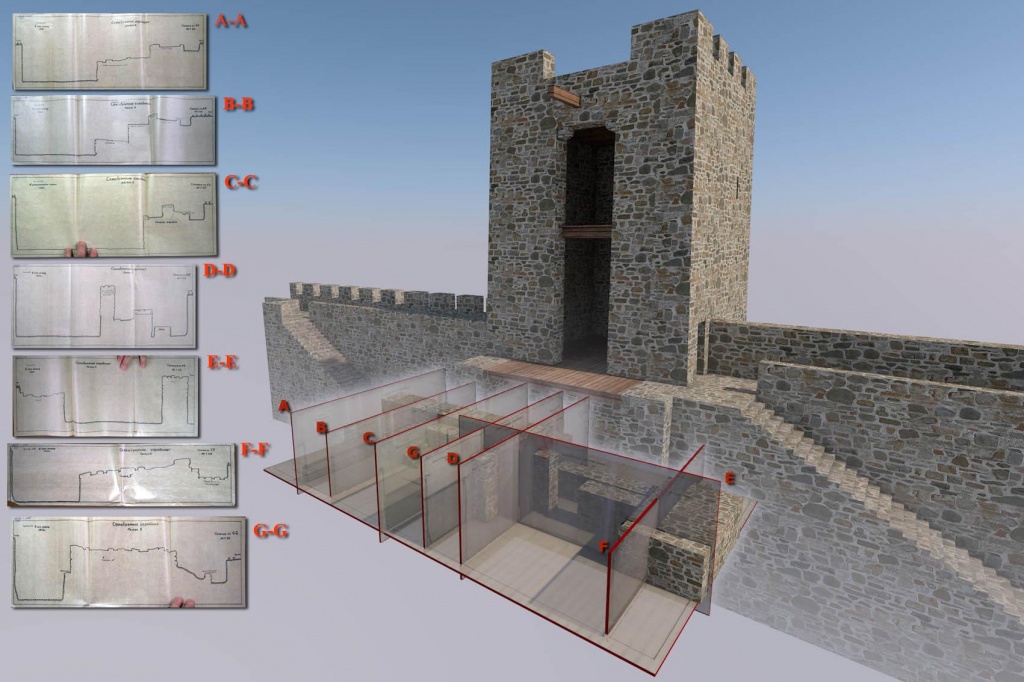
Рис. 6. Визуализация фортификационных сооружений Семибратнего городища на основе фотограмметрии (2017-2018 гг.) и планов раскопок Н.В. Анфимова. Вып. В.В. Моором.
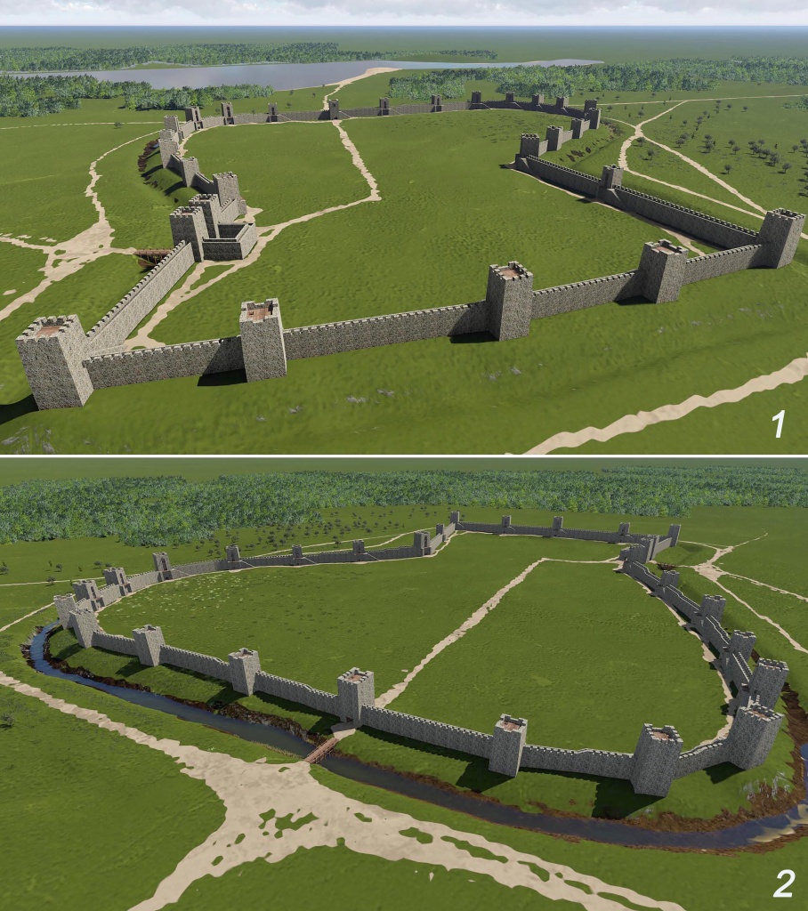
Рис. 7. Визуализация фортификационных сооружений Семибратнего городища в ландшафтном окружении основе фотограмметрии (2017-2018 гг.) и плана раскопа, вып. В.В. Моором.
Семибратние курганы
Индикатором значимости данного центра являются богатые захоронения в группе расположенных неподалеку Больших Семибратних курганов, первые из которых были произведены не позднее середины V в. до н.э., а последние – в первой четверти IV в. до н.э.
Несмотря на грандиозность объектов, полевые исследования со времён В.Г. Тизенгаузена (1875–1876) на этом памятнике не проводились, поэтому в историографии до сих пор существуют довольно смутные представления о топографии памятника. В публикации результатов раскопок приведено описание ландшафтного окружения памятника: «Группа курганов, известная на Кубани под названием ‟Семи Братьев”, находится на левом берегу этой реки, … в 25-ти верстах к северо-востоку от г. Анапы (Горгиппии), и расположена на небольшой, поросшей мелким дубом, возвышенности, в двух верстах к югу от окруженного плавнями Кубанскаго лимана Разнокола. К северу от этого лимана и извивающейся за ним Кубани тянется незначительный кряж, с разбросанными кое-где курганами». О взаиморасположении объектов некрополя имеется только словесное описание: «Шесть курганов из группы ‟Семи Братьев” лежат почти по прямой линии, от востока к западу, седьмой же и самый высокий стоит отдельно, в 118 саженях к югу от крайнего западного».
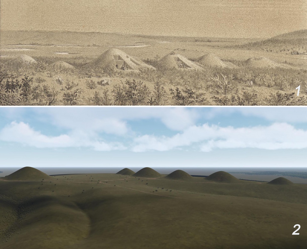
Рис. 8. Семибратние курганы: 1 – вид с запада (ОАК за 1876, СПб, 1879), 2 – вид с юга (визуализация на основе фотограмметрии (2017-2018 гг.), вып. В.В. Моором)
Таким образом, в настоящее время остаются актуальными задачи по выработке характеристики ландшафтного окружения и введению в научный оборот плана могильника.
При съёмке Семибратних курганов производилась надирная площадная съёмка, она охватила гораздо большие площади — около 150 га, однако для построения детальных трёхмерных моделей дополнительно использовалась перспективная съёмка с малых высот группы основных курганов. Часть курганов находится в лесной полосе, что затрудняет получение точного рельефа по материалам аэрофотосъёмки. Для того, чтобы избежать влияния растительности на общую картину рельефа, выполнялась инструментальная съемка необходимых участков, а также классификация облака точек, что позволило в дальнейшем выполнить комбинирование материалов и получить качественную цифровую модель рельефа (ЦМР). Использование трёхмерных моделей позволяет получить исчерпывающую информацию о местности, проанализировать полученные данные визуально, а также визуализировать их в геоинформационной среде и выполнить пространственный анализ материалов, а именно уточнить взаимное расположение курганов и современное состояние насыпей.
По материалам аэрофотосъемки было отчетливо отождествлено положение шести курганов, расположенных в двух километрах на восток от Красной горки, в двух километрах на юг от лимана Разнокол и примерно в пяти километрах от современного русла реки Кубань.
Основной (самый крупный) курган расположен на вершине возвышенности (104 метра над уровнем моря), на расстоянии около 250 метров от остальной группы. Его высота (17 метров) оказалась несколько больше, чем было указано в публикации (7 саженей (15 м): ОАК за 1875, 1878. С. IV-V) при диаметре около 100 метров (рис. 9, 1). Рядом с ним (юго-западнее) читается основание еще одной, отраженной на карте Генштаба насыпи (Рис. 2, 1, 2).
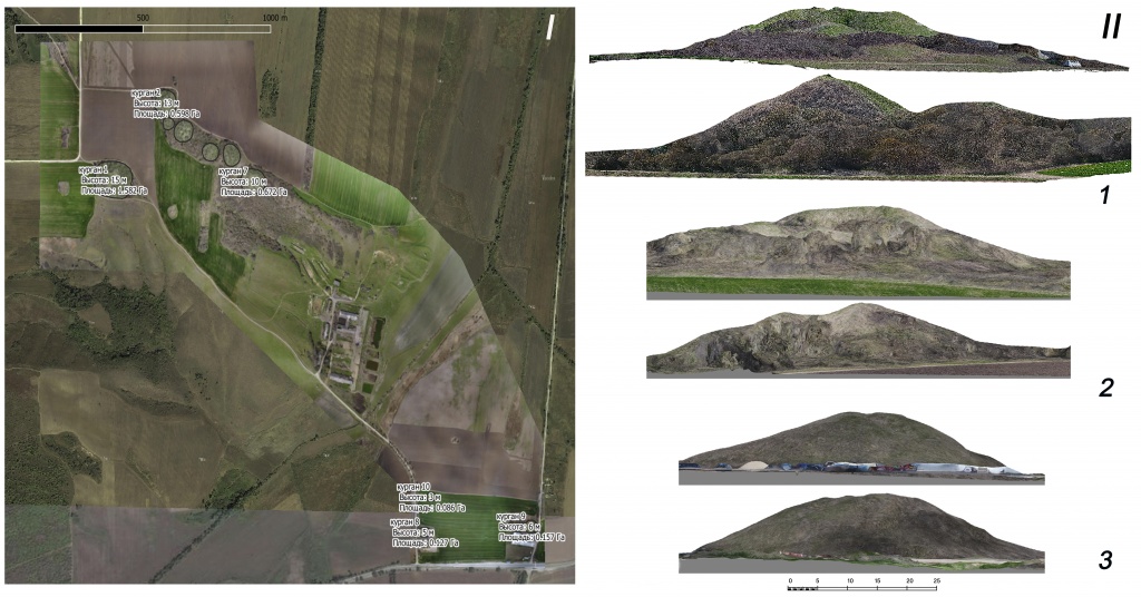
Рис. 9. Семибратние курганы: I – ортофотоплан могильника; II – профиля курганов: 1 – Первый Семибратний; 2 – Четвертый Семибратний; 3 – насыпь 9.
Остальные курганы находятся на юго-востоке от основного и расположены цепочкой по кромке гряды ориентированной по оси СЗС – ВЮВ. Расстояние между соседними курганами разнится от 50 до 70 метров, а вся гряда простирается на 500 метров.
Первый курган в гряде – Второй Семибратний – в настоящее время имеет высоту 14 метров (96 метров над уровнем моря по вершине кургана) при диаметре около 60 метров. Третий Семибратний, наименьший из всей группы, высотой 4,5 саж. (ОАК за 1875, 1878. С. VIII), ныне читается на местности очень плохо.
Четвертый Семибратний оказался самым крупным после насыпи 1 (в публикации он имеет высоту около 6 саженей (13 м) (ОАК за 1875, 1878. С. IX-X): его высота 14 метров (100 метров над уровнем моря), а диаметр около 80 метров.
Высота Пятого Семибратнего кургана (10 метров (92 метра над уровнем моря)) при диаметре насыпи 60 метров совсем не соответствует данным В.Г. Тизенгаузена (3 и 1/6 саж.: ОАК за 1875, 1878. С. IX).
Судя по публикации, насыпь Шестого Семибратнего кургана имела высоту около 5 и 1/3 сажени (11,4 м) (ОАК за 1875, 1878. С. X), тогда как в настоящее время она не превышает 8 метров и 60 метров в диаметре. Седьмой курган высотой 8 метров (87 метров над уровнем моря) и 70 метров в диаметре сопоставим с насыпью 6, хотя по данным В.Г. Тизенгаузена, он возвышался всего на 3 саж. (ОАК за 1875, 1878. С. XIII). Наличие разночтений в описаниях и планах курганов уже отмечалось в литературе [11, с. 174].
Также в ходе аэросъемки местности южнее были обнаружены еще три курганных насыпи существенно меньших размеров, расположенных за рекой Капиляпсин у основания Веселой горы (вдоль автодороги 03А-009 Крымск — Джигинка). Высоты курганов составляют 3, 5 и 6 метров (44, 48 и 49 метров от уровня моря, соответственно).
Проанализировав серию космических снимков с 2011 года были выявлены зоны антропогенных объектов – предположительно дорог, протянувшихся вдоль южной стены Семибратнего городища.
На основе полученного набора геопространственных данных (ортофотопланы, трехмерные модели и цифровые модели рельефа) и анализа архивных материалов раскопок В.Г. Тизенгаузена (1875–1876) была предложена виртуальная реконструкция некрополя и конструкции комплекса сооружений насыпи Седьмого кургана (Рис. 10, 11).

Рис. 10. Седьмой курган: 1 – план (Коровина, 1957); 2,3 – визуализация насыпи и раскопов на основе фотограмметрии (2017-2018 гг.) и плана раскопа, вып. В.В. Моором.
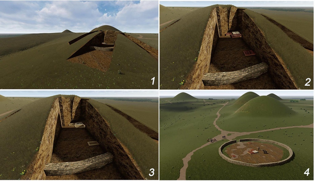
Рис. 11. Седьмой курган: визуализация насыпи, раскопов и погребальных сооружений на основе фотограмметрии и плана раскопа, вып. В.В. Моором.
Выводы
Цифровая аэрофотосъемка позволяет фиксировать современный ландшафт, изменения которого в изучаемом районе особенно в последнем десятелетии очень стремительны.
Благодаря выполнению аэрофотосъёмки с БПЛА возрастает эффективность и оперативность работ: удается обследовать значительные по площади объекты в довольно короткие сроки. Вместе с тем, фотограмметрическая обработка данных обеспечивает требуемую точность работ, а сверхвысокое пространственное разрешение позволяет обратить внимание на объекты, не заметные при наземном обследовании.
Сбор и визуализация данных в ГИС открывают широкие возможности по структурированию материалов: в цифровой среде возможна увязка различных и разновременных источников, что позволяет расположить исследуемый объект и его цифровую реконструкцию в зачастую утраченном историческом антропогенном ландшафте.
References
1. Goroncharovskii V.A., Ivanchik A.I. Sindy // Antichnoe nasledie Kubani / Pod red. akad. G.M. Bongard-Levina, V.D. Kuznetsova. M., 2010.T. 1. S. 228-232.
2. Kruglikova I.T. Sindskaya gavan'. Gorgippiya. Anapa. M.: «Nauka», 1977. 88 s.
3. Blavatskaya T.V. Posvyashchenie Levkona I // RA. 1993. № 2. S. 34-47.
4. Novichikhin A.M. Granitsy Sindiki // Bylye gody. 2011. № 3 (21). S. 11-15.
5. Anfimov N.V. Drevnee zoloto Kubani. Krasnodar, 1987. 232 s.
6. Blavatskaya T.V. Ocherki politicheskoi istorii Bospora v V-IV vv. do n. e. M, 1959. 161 s.
7. Malyshev A.A., Trebeleva G.V. Khora Gorgippii: landshaft, resursy, evolyutsiya sistemy rasseleniya (po materialam poluostrova Abrau) // VIII «Anfimovskie chteniya» po arkheologii Zapadnogo Kavkaza. Voina i torgovlya kak faktory istoricheskogo razvitiya narodov Zapadnogo Kavkaza v drevnosti i srednevekov'e. Materialy mezhdunarodnoi arkheologicheskoi konferentsii (g. Anapa, 30 maya – 1 iyunya 2018 g.). Krasnodar, 2018. S. 179-187.
8. Malyshev A.A. Zoloto Kubani // Rodina. 2005. №1. S. 69-73.
9. Smekalova T.N., Goroncharovskii V.A., Eliseev A.Yu., Geomagnitnaya s''emka na territorii Labrisa (Semibratnego gorodishcha) v 2006-2008 gg. // ΣΥΜΒΟΛΕΑ. Antichnyi mir Severnogo Prichernomor'ya. Noveishie nakhodki i otkrytiya. 2010. Vyp. 1. S. 58-62.
10. Tolstikov V.P., Nefedkin A.K. Armiya. Vooruzhenie. Fortifikatsiya // Antichnoe nasledie Kubani / Pod red. akad. G.M. Bongard-Levina, V.D. Kuznetsova. M., 2010. T. 2. S. 602-655.
11. Korovina A.K. 1957. K voprosu ob izuchenii Semibratnikh kurganov // SA. № 2. S. 174-187.
Link to this article
You can simply select and copy link from below text field.
|
|


